
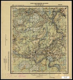
Ricerca
Visualizza i risultati come:
Risultati della ricerca
-
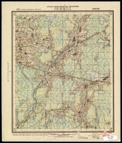
- Descrizione:
- 1888
- Soggetto:
- Geographic Subject: Porechye, Topical Subject: Maps, and Topical Subject: Soviet Union
- Editore:
- Генеральный штаб РККА
- Lingua:
- Russian
- data di creazione:
- 1931
- Identifier:
- VAC9619-004073
- Genre:
- Topographic Maps and Military Maps
- Geographic Location:
- Coordinates: 53.667, 24, 54, 24.5
- Related URL:
- DataCORE Dataset Download: https://datacore.iu.edu/concern/data_sets/3197xm879
- Abstract:
- Modern area represented: Porechye, Hrodna oblast, Belarus
- Call Number:
- G7000 s100 .S7 sheet N-35-73
- City:
- Пожэчэ (Porzecze)
- Copyright Holder:
- No Copyright - United States
- Country:
- СССР (USSR)
- State/Province:
- Белорусская ССР (Byelorussian Soviet Socialist Republic), Белостокская область (Belastok oblast), and Барановичская область (Baranavichy oblast)
- Physical Description:
- Scale: 1:100,000
- Persistent URL:
- http://purl.dlib.indiana.edu/iudl/images/VAC9619/VAC9619-004073
- Provenance:
- DMA Topographic Center, Army Map Service Library
-
- Descrizione:
- 1909
- Soggetto:
- Topical Subject: Soviet Union, Topical Subject: Maps, and Geographic Subject: Dolginovo
- Editore:
- Генеральный штаб РККА
- Lingua:
- Russian
- data di creazione:
- 1931
- Identifier:
- VAC9619-004057
- Genre:
- Topographic Maps and Military Maps
- Geographic Location:
- Coordinates: 54.333, 27, 54.667, 27.5
- Related URL:
- DataCORE Dataset Download: https://datacore.iu.edu/concern/data_sets/3197xm861
- Abstract:
- Modern area represented: Dolginovo, Belarus
- Call Number:
- G7000 s100 .S7 sheet N-35-55
- Caption:
- Не подлежит оглашению
- City:
- Долгинув (Dolginovo)
- Copyright Holder:
- No Copyright - United States
- Country:
- СССР (USSR)
- State/Province:
- Белорусская ССР (Byelorussian Soviet Socialist Republic)
- Physical Description:
- Scale: 1:100,000
- Persistent URL:
- http://purl.dlib.indiana.edu/iudl/images/VAC9619/VAC9619-004057
- Provenance:
- DMA Topographic Center, Army Map Service Library
-
- Descrizione:
- 1916
- Soggetto:
- Topical Subject: Maps, Geographic Subject: Myory, and Topical Subject: Soviet Union
- Editore:
- Генеральный штаб РККА
- Lingua:
- Russian
- data di creazione:
- 1931
- Identifier:
- VAC9619-004021
- Genre:
- Topographic Maps and Military Maps
- Geographic Location:
- Coordinates: 55.333, 27.5, 55.667, 28
- Related URL:
- DataCORE Dataset Download: https://datacore.iu.edu/concern/data_sets/1g05fc430
- Abstract:
- Modern area represented: Myory, Vitebsk oblast, Belarus
- Call Number:
- G7000 s100 .S7 sheet N-35-20
- City:
- Меры (Myory)
- Copyright Holder:
- No Copyright - United States
- Country:
- СССР (USSR)
- State/Province:
- Белорусская ССР (Byelorussian Soviet Socialist Republic) and Вилейская область (Vileyka oblast)
- Physical Description:
- Scale: 1:100,000
- Persistent URL:
- http://purl.dlib.indiana.edu/iudl/images/VAC9619/VAC9619-004021
- Provenance:
- DMA Topographic Center, Army Map Service Library, OMAHA
-
- Descrizione:
- 1930
- Soggetto:
- Topical Subject: Maps, Geographic Subject: Ostrołęka, and Topical Subject: Soviet Union
- Editore:
- Генеральный штаб РККА
- Lingua:
- Russian
- data di creazione:
- 1931
- Identifier:
- VAC9619-003970
- Genre:
- Topographic Maps and Military Maps
- Geographic Location:
- Coordinates: 53, 21.5, 53.333, 22
- Related URL:
- DataCORE Dataset Download: https://datacore.iu.edu/concern/data_sets/bz60cx150
- Abstract:
- Modern area represented: Ostrołęka, Masovian Voivodeship, Poland
- Call Number:
- G7000 s100 .S7 sheet N-34-104
- City:
- Остроленка (Ostrolenka)
- Copyright Holder:
- No Copyright - United States
- State/Province:
- Белорусская ССР (Byelorussian Soviet Socialist Republic) and Область государственных интересов Германии (Region of German state interests)
- Physical Description:
- Scale: 1:100,000
- Persistent URL:
- http://purl.dlib.indiana.edu/iudl/images/VAC9619/VAC9619-003970
- Provenance:
- DMA Topographic Center, Army Map Service Library, OMAHA, Auswärtiges Amt. Geographischer Dienst
-
- Descrizione:
- 1891
- Soggetto:
- Geographic Subject: Nesterov, Topical Subject: Soviet Union, and Topical Subject: Maps
- Editore:
- Генеральный штаб РККА
- Lingua:
- Russian
- data di creazione:
- 1931
- Identifier:
- VAC9619-003927
- Genre:
- Topographic Maps and Military Maps
- Geographic Location:
- Coordinates: 54.333, 22.5, 54.667, 23
- Related URL:
- DataCORE Dataset Download: https://datacore.iu.edu/concern/data_sets/rb68xc73m
- Abstract:
- Modern area represented: Nesterov, Kaliningrad oblast, Russia
- Call Number:
- G7000 s100 .S7 sheet N-34-58
- City:
- Шталлупенен (Stallupönen)
- Copyright Holder:
- No Copyright - United States
- Country:
- Германия (Germany) and Литва (Lithuania)
- Physical Description:
- Scale: 1:100,000
- Persistent URL:
- http://purl.dlib.indiana.edu/iudl/images/VAC9619/VAC9619-003927
- Provenance:
- DMA Topographic Center, Army Map Service Library, OMAHA
-
- Descrizione:
- 1929
- Soggetto:
- Geographic Subject: Kholm, Topical Subject: Soviet Union, and Topical Subject: Maps
- Editore:
- Военно-топографическое управление
- Lingua:
- Russian
- data di creazione:
- 1931
- Identifier:
- VAC9619-003546
- Genre:
- Topographic Maps and Military Maps
- Geographic Location:
- Coordinates: 57, 31, 57.167, 31.25
- Related URL:
- DataCORE Dataset Download: https://datacore.iu.edu/concern/data_sets/8p58pd72f
- Abstract:
- Modern area represented: Холм (Kholm), Novgorodskaya oblast, Russia
- Call Number:
- GM G7000 s50 .S68 sheet O-36-99-C
- Caption:
- Не подлежит оглашению and Captured map
- City:
- Холм (Kholm)
- Copyright Holder:
- No Copyright - United States
- Country:
- СССР (USSR)
- State/Province:
- Западная область (Western oblast) and РСФСР (RSFSR)
- Physical Description:
- Scale: 1:50,000
- Persistent URL:
- http://purl.dlib.indiana.edu/iudl/images/VAC9619/VAC9619-003546
- Provenance:
- DMA Topographic Center, Army Map Service Library, Library of Congress Geography & Map Division
-
- Descrizione:
- 1929
- Soggetto:
- Topical Subject: Maps, Geographic Subject: Grukhovka, and Topical Subject: Soviet Union
- Editore:
- Военно-топографическое управление
- Lingua:
- Russian
- data di creazione:
- 1931
- Identifier:
- VAC9619-003543
- Genre:
- Military Maps and Topographic Maps
- Geographic Location:
- Coordinates: 57, 30.75, 57.167, 31
- Related URL:
- DataCORE Dataset Download: https://datacore.iu.edu/concern/data_sets/hh63sw71w
- Abstract:
- Modern area represented: Груховка (Grukhovka), Novgorodskaya oblast, Russia
- Call Number:
- GM G7000 s50 .S68 sheet O-36-98-D
- Caption:
- Captured map and Не подлежит оглашению
- City:
- Груховка (Grukhovka)
- Copyright Holder:
- No Copyright - United States
- Country:
- СССР (USSR)
- State/Province:
- РСФСР (RSFSR) and Западная область (Western oblast)
- Physical Description:
- Scale: 1:50,000
- Persistent URL:
- http://purl.dlib.indiana.edu/iudl/images/VAC9619/VAC9619-003543
- Provenance:
- Army Map Service Library, OMAHA, Library of Congress Geography & Map Division
-
- Descrizione:
- 1927
- Soggetto:
- Topical Subject: Soviet Union, Topical Subject: Maps, and Geographic Subject: Rudnya
- Editore:
- Военно-топографическое управление
- Lingua:
- Russian
- data di creazione:
- 1931
- Identifier:
- VAC9619-003497
- Genre:
- Military Maps and Topographic Maps
- Geographic Location:
- Coordinates: 56.0, 32.0, 56.16667, 32.25
- Related URL:
- DataCORE Dataset Download: https://datacore.iu.edu/concern/data_sets/pc289j90s
- Abstract:
- Modern area represented: Рудня (Rudnya), Tverskaya oblast, Russia
- Call Number:
- G7000 s50 .S68 sheet O-36-137-C
- Caption:
- Секретно
- City:
- Рудня (Rudnya)
- Copyright Holder:
- No Copyright - United States
- Country:
- СССР (USSR)
- State/Province:
- Западная область (Western oblast) and РСФСР (RSFSR)
- Physical Description:
- Scale: 1:50,000
- Persistent URL:
- http://purl.dlib.indiana.edu/iudl/images/VAC9619/VAC9619-003497
- Provenance:
- CIA Map Branch -- Received
-
- Descrizione:
- 1927
- Soggetto:
- Topical Subject: Maps, Geographic Subject: Kostino, and Topical Subject: Soviet Union
- Editore:
- Военно-топографическое управление
- Lingua:
- Russian
- data di creazione:
- 1931
- Identifier:
- VAC9619-003496
- Genre:
- Military Maps and Topographic Maps
- Geographic Location:
- Coordinates: 56.16667, 32.25, 56.3333, 32.5
- Related URL:
- DataCORE Dataset Download: https://datacore.iu.edu/concern/data_sets/zg64tm67b
- Abstract:
- Modern area represented: Костино (Kostino), Tverskaya oblast, Russia
- Call Number:
- G7000 s50 .S68 sheet O-36-137-B
- Caption:
- Секретно
- City:
- Костино (Kostino)
- Copyright Holder:
- No Copyright - United States
- Country:
- СССР (USSR)
- State/Province:
- Западная область (Western oblast) and РСФСР (RSFSR)
- Physical Description:
- Scale: 1:50,000
- Persistent URL:
- http://purl.dlib.indiana.edu/iudl/images/VAC9619/VAC9619-003496
- Provenance:
- CIA Map Branch -- Received
-
- Descrizione:
- 1927
- Soggetto:
- Geographic Subject: Sutrimino, Topical Subject: Maps, and Topical Subject: Soviet Union
- Editore:
- Военно-топографическое управление
- Lingua:
- Russian
- data di creazione:
- 1931
- Identifier:
- VAC9619-003493
- Genre:
- Military Maps and Topographic Maps
- Geographic Location:
- Coordinates: 56, 31.5, 56.167, 31.75
- Related URL:
- DataCORE Dataset Download: https://datacore.iu.edu/concern/data_sets/xp68kh09j
- Abstract:
- Modern area represented: Сутрмино (Sutrimino), Tverskaya oblast, Russia
- Call Number:
- G7000 s50 .S68 sheet O-36-136-C
- Caption:
- Captured map and Секретно
- City:
- Сутрмино (Sutrimino)
- Copyright Holder:
- No Copyright - United States
- Country:
- СССР (USSR)
- State/Province:
- РСФСР (RSFSR) and Западная область (Western oblast)
- Physical Description:
- Scale: 1:50,000
- Persistent URL:
- http://purl.dlib.indiana.edu/iudl/images/VAC9619/VAC9619-003493
- Provenance:
- Army Map Service Library, OMAHA, Library of Congress Geography & Map Division
