
Search Constraints
You searched for:
Creator
Geological Survey (U.S.)
Remove constraint Creator: Geological Survey (U.S.)
Date Created
1948
Remove constraint Date Created: 1948
Holding Location
B-WELLS
Remove constraint Holding Location: B-WELLS
« Previous |
1 - 10 of 13
|
Next »
Search Results
-
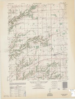
- Subject:
- Geographic Subject: Johnson County (Ind.)
- Creator:
- Geological Survey (U.S.) and United States. Army Map Service
- Publisher:
- United States. Army Map Service
- Date Created:
- 1948
- Identifier:
- VAC3073-M-01444
- Genre:
- Quadrangle maps, Topographic maps, and 7.5 minute topographic maps
- Geographic Location:
- Coordinates: W0861500 W0860730 N0393000 N0392230
- Related URL:
- Catalog URL: https://iucat.iu.edu/catalog/18387703
- Abstract:
- Printed with vegetation. Prepared under the direction of the Chief of Engineers by the Army Map Service (GE), Corps of Engineers, Department of the Army , ...
- Call Number:
- G4090 s25 .U5 Trafalgar 1948 V
- Caption:
- Imprint: Washington, D.C. : Army Map Service, 1948.
- Physical Description:
- Dimensions: 56 x 45 cm or smaller and Scale: 1:25,000
- Alternate Identifier:
- Title Control Number: a18387703
- Persistent URL:
- https://purl.dlib.indiana.edu/iudl/images/VAC3073/VAC3073-M-01444
- Provenance:
- Part of United States. Army Map Service, Indiana 1:25,000.
-
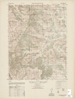
- Subject:
- Geographic Subject: Bartholomew County (Ind.), Geographic Subject: Jackson County (Ind.), and Geographic Subject: Brown County (Ind.)
- Creator:
- United States. Army Map Service and Geological Survey (U.S.)
- Publisher:
- United States. Army Map Service
- Date Created:
- 1948
- Identifier:
- VAC3073-M-01445
- Genre:
- Topographic maps, Quadrangle maps, and 7.5 minute topographic maps
- Geographic Location:
- Coordinates: W0860730 W0860000 N0390730 N0390000
- Related URL:
- Catalog URL: https://iucat.iu.edu/catalog/18387823
- Abstract:
- Printed with vegetation. Prepared under the direction of the Chief of Engineers by the Army Map Service (GE), Corps of Engineers, Department of the Army , ...
- Call Number:
- G4090 s25 .U5 Waymansville 1948 V
- Caption:
- Imprint: Washington, D.C. : Army Map Service, Corps of Engineers, Department of the Army, 1948.
- Physical Description:
- Scale: 1:25,000 and Dimensions: 56 x 45 cm or smaller
- Alternate Identifier:
- Title Control Number: a18387823
- Persistent URL:
- https://purl.dlib.indiana.edu/iudl/images/VAC3073/VAC3073-M-01445
- Provenance:
- Part of United States. Army Map Service, Indiana 1:25,000.
-
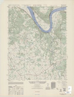
- Subject:
- Geographic Subject: Harrison County (Ind.) and Geographic Subject: Meade County (Ky.)
- Creator:
- United States. Army Air Forces, United States. Army Map Service, and Geological Survey (U.S.)
- Publisher:
- United States. Army Map Service
- Date Created:
- 1948
- Identifier:
- VAC3073-M-01442
- Genre:
- Quadrangle maps, Topographic maps, and 7.5 minute topographic maps
- Geographic Location:
- Coordinates: W0860730 W0860000 N0380000 N0375230
- Related URL:
- Catalog URL: https://iucat.iu.edu/catalog/18387699
- Abstract:
- Printed with vegetation. Prepared under the direction of the Chief of Engineers by the Army Map Service, Corps of Engineers, Department of the Army , compi...
- Call Number:
- G4090 s25 .U5 Rockhaven 1948 V
- Caption:
- Imprint: Washington, D.C. : Army Map Service, Corps of Engineers, Department of the Army, 1948.
- Physical Description:
- Scale: 1:25,000 and Dimensions: 56 x 45 cm or smaller
- Alternate Identifier:
- Title Control Number: a18387699 , a18387701
- Persistent URL:
- https://purl.dlib.indiana.edu/iudl/images/VAC3073/VAC3073-M-01442
- Provenance:
- Part of United States. Army Map Service, Indiana 1:25,000.
-
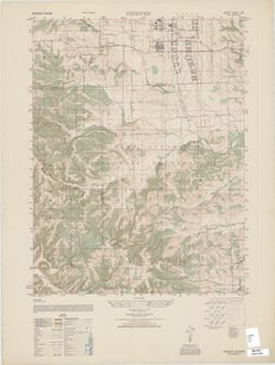
- Subject:
- Geographic Subject: Johnson County (Ind.), Geographic Subject: Brown County (Ind.), and Geographic Subject: Bartholomew County (Ind.)
- Creator:
- United States. Army Map Service and Geological Survey (U.S.)
- Publisher:
- United States. Army Map Service
- Date Created:
- 1948
- Identifier:
- VAC3073-M-01441
- Genre:
- Quadrangle maps, Topographic maps, and 7.5 minute topographic maps
- Geographic Location:
- Coordinates: W0860730 W0860000 N0392230 N0391500
- Related URL:
- Catalog URL: https://iucat.iu.edu/catalog/18376552
- Abstract:
- Printed with vegetation. Prepared under the direction of the Chief of Engineers by the Army Map Service (GE), Corps of Engineers, Department of the Army , ...
- Call Number:
- G4090 s25 .U5 Nineveh 1948 V
- Caption:
- Imprint: Washington, D.C. : Army Map Service, Corps of Engineers, Department of the Army, 1948.
- Physical Description:
- Dimensions: 56 x 45 cm or smaller and Scale: 1:25,000
- Alternate Identifier:
- Title Control Number: a18376552
- Persistent URL:
- https://purl.dlib.indiana.edu/iudl/images/VAC3073/VAC3073-M-01441
- Provenance:
- Part of United States. Army Map Service, Indiana 1:25,000.
-
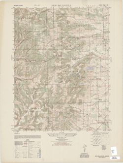
- Subject:
- Geographic Subject: Brown County (Ind.) and Geographic Subject: Bartholomew County (Ind.)
- Creator:
- United States. Army Map Service and Geological Survey (U.S.)
- Publisher:
- United States. Army Map Service
- Date Created:
- 1948
- Identifier:
- VAC3073-M-01439
- Genre:
- Quadrangle maps, Topographic maps, and 7.5 minute topographic maps
- Geographic Location:
- Coordinates: W0860730 W0860000 N0391500 N0390730
- Related URL:
- Catalog URL: https://iucat.iu.edu/catalog/18376548
- Abstract:
- Printed with vegetation. Prepared under the direction of the Chief of Engineers by the Army Map Service (GE), Corps of Engineers, Department of the Army , ...
- Call Number:
- G4090 s25 .U5 New Bellsville 1948 V
- Caption:
- Imprint: Washington, D.C. : Army Map Service, 1948.
- Physical Description:
- Scale: 1:25,000 and Dimensions: 56 x 45 cm or smaller
- Alternate Identifier:
- Title Control Number: a18376548
- Persistent URL:
- https://purl.dlib.indiana.edu/iudl/images/VAC3073/VAC3073-M-01439
- Provenance:
- Part of United States. Army Map Service, Indiana 1:25,000.
-
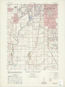
- Subject:
- Geographic Subject: Marion County (Ind.), Geographic Subject: Johnson County (Ind.), and Geographic Subject: Madison County (Ind.)
- Creator:
- Geological Survey (U.S.) and United States. Army Map Service
- Publisher:
- United States. Army Map Service
- Date Created:
- 1948
- Identifier:
- VAC3073-M-01437
- Genre:
- Topographic maps, 7.5 minute topographic maps, and Quadrangle maps
- Geographic Location:
- Coordinates: W0861500 W0860730 N0394500 N0393730
- Related URL:
- Catalog URL: https://iucat.iu.edu/catalog/18376543
- Abstract:
- Printed with vegetation. Prepared under the direction of the Chief of Engineers by the Army Map Service (AM), Corps of Engineers, Department of the Army , ...
- Call Number:
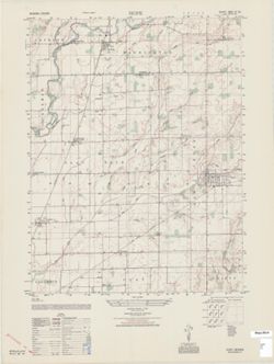
- G4090 s25 .U5 Maywood 1948 V
- Caption:
- Imprint: Washington, D.C. : Army Map Service, 1948.
- Physical Description:
- Dimensions: 56 x 45 cm or smaller and Scale: 1:25,000
- Alternate Identifier:
- Title Control Number: a18376543
- Persistent URL:
- https://purl.dlib.indiana.edu/iudl/images/VAC3073/VAC3073-M-01437
- Provenance:
- Part of United States. Army Map Service, Indiana 1:25,000.
-
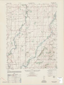
- Subject:
- Geographic Subject: Shelby County (Ind.) and Geographic Subject: Johnson County (Ind.)
- Creator:
- United States. Defense Mapping Agency. Topographic Center and Geological Survey (U.S.)
- Publisher:
- United States. Defense Mapping Agency. Topographic Center
- Date Created:
- 1948
- Identifier:
- VAC3073-M-01435
- Genre:
- Topographic maps, Quadrangle maps, and 7.5 minute topographic maps
- Geographic Location:
- Coordinates: W0860000 W0855230 N0393000 N0392230
- Related URL:
- Catalog URL: https://iucat.iu.edu/catalog/18376540
- Abstract:
- Printed with vegetation. Prepared by the Defense Mapping Agency Topographic Center. Variant title: Indiana 1:25,000. Filing title: Marietta, Indiana. Stand...
- Call Number:
- G4091.C2 1975 .U55 Marietta
- Caption:
- Imprint: Washington, D.C. : Defense Mapping Agency Topographic Center, 1975.
- Physical Description:
- Dimensions: 56 x 45 cm or smaller and Scale: 1:25,000
- Alternate Identifier:
- Title Control Number: a18376540
- Persistent URL:
- https://purl.dlib.indiana.edu/iudl/images/VAC3073/VAC3073-M-01435
- Provenance:
- Part of United States. Army Map Service, Indiana 1:25,000.
-
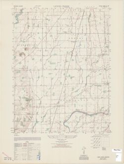
- Subject:
- Geographic Subject: Shelby County (Ind.)
- Creator:
- United States. Army Map Service and Geological Survey (U.S.)
- Publisher:
- United States. Army Map Service
- Date Created:
- 1948
- Identifier:
- VAC3073-M-01434
- Genre:
- Topographic maps, Quadrangle maps, and 7.5 minute topographic maps
- Geographic Location:
- Coordinates: W0855230 W0854500 N0393000 N0392230
- Related URL:
- Catalog URL: https://iucat.iu.edu/catalog/18376538
- Abstract:
- Printed with vegetation. Prepared under the direction of the Chief of Engineers by the Army Map Service (GE), Corps of Engineers, Department of the Army , ...
- Call Number:
- G4090 s25 .U5 Lewis Creek 1948 V
- Caption:
- Imprint: Washington, D.C. : Army Map Service, Corps of Engineers, Department of the Army, 1948.
- Physical Description:
- Dimensions: 56 x 45 cm or smaller and Scale: 1:25,000
- Alternate Identifier:
- Title Control Number: a18376538
- Persistent URL:
- https://purl.dlib.indiana.edu/iudl/images/VAC3073/VAC3073-M-01434
- Provenance:
- Part of United States. Army Map Service, Indiana 1:25,000.
-
- Subject:
- Geographic Subject: Shelby County (Ind.) and Geographic Subject: Bartholomew County (Ind.)
- Creator:
- United States. Army Map Service and Geological Survey (U.S.)
- Publisher:
- United States. Army Map Service
- Date Created:
- 1948
- Identifier:
- VAC3073-M-01429
- Genre:
- 7.5 minute topographic maps, Topographic maps, and Quadrangle maps
- Geographic Location:
- Coordinates: W0855230 W0854500 N0392230 N0391500
- Related URL:
- Catalog URL: https://iucat.iu.edu/catalog/18376530
- Abstract:
- Printed with vegetation. Prepared under the direction of the Chief of Engineers by the Army Map Service (GE), Corps of Engineers, Department of the Army , ...
- Call Number:
- G4090 s25 .U5 Hope 1948 V
- Caption:
- Imprint: Washington, D.C. : Army Map Service, Corps of Engineers, Department of the Army, 1948.
- Physical Description:
- Dimensions: 56 x 45 cm or smaller and Scale: 1:25,000
- Alternate Identifier:
- Title Control Number: a18376530
- Persistent URL:
- https://purl.dlib.indiana.edu/iudl/images/VAC3073/VAC3073-M-01429
- Provenance:
- Part of United States. Army Map Service, Indiana 1:25,000.
-
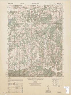
- Subject:
- Geographic Subject: Brown County (Ind.) and Geographic Subject: Johnson County (Ind.)
- Creator:
- United States. Army Map Service and Geological Survey (U.S.)
- Publisher:
- United States. Army Map Service
- Date Created:
- 1948
- Identifier:
- VAC3073-M-01428
- Genre:
- 7.5 minute topographic maps, Topographic maps, and Quadrangle maps
- Geographic Location:
- Coordinates: W0861500 W0860730 N0392230 N0391500
- Related URL:
- Catalog URL: https://iucat.iu.edu/catalog/18376518
- Abstract:
- Printed with vegetation. Prepared under the direction of the Chief of Engineers by the Army Map Service (GE), Corps of Engineers, Department of the Army , [...
- Call Number:
- G4090 s25 .U5 Fruitdale 1948 V
- Caption:
- Imprint: Washington, D.C. : Army Map Service, Corps of Engineers, Department of the Army, 1948.
- Physical Description:
- Dimensions: 56 x 45 cm or smaller and Scale: 1:25,000
- Alternate Identifier:
- Title Control Number: a18376518
- Persistent URL:
- https://purl.dlib.indiana.edu/iudl/images/VAC3073/VAC3073-M-01428
- Provenance:
- Part of United States. Army Map Service, Indiana 1:25,000.
