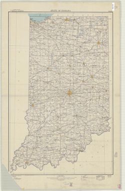
John H. Renshaw, geographer in charge , control by George T. Hawkins , topography by Chas. E. Cooke. Filing title: Owensboro, Ind.-Ky. Edition of Nov. 1901. ...
Call Number:
G4090 s62 .G4 Owensboro 1901 rep 1950
Caption:
Imprint: Washington, D.C. : U.S. Geological Survey, 1950
Physical Description:
Scale: 1:62,500 and Dimensions: 45 x 42 cm or smaller
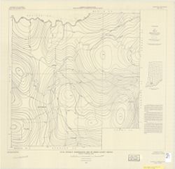
Filing title: Franklin, Ind. Mapped, edited, and published by Geological Survey. Edition of 1950. Polyconic projection. Relief shown by contours and spot hei...
Geographic Subject: Brown County (Ind.), Geographic Subject: Bartholomew County (Ind.), Geographic Subject: Johnson County (Ind.), and Topical Subject: Veget...
Creator:
Geological Survey (U.S.) and United States. Army. Corps of Engineers
Filing title: Franklin, Ind. Mapped, edited, and published by Geological Survey. Edition of 1950. Polyconic projection. Relief shown by contours and spot hei...
Geographic Subject: Johnson County (Ind.), Geographic Subject: Shelby County (Ind.), Geographic Subject: Bartholomew County (Ind.), and Topical Subject: Vege...
Creator:
Geological Survey (U.S.) and United States. Army. Corps of Engineers
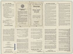
Geographic Subject: Brown County State Park (Ind.), Geographic Subject: Indiana, and Topical Subject: Trails
Creator:
Indiana. Division of State Parks, Lands, and Waters
Publisher:
Indiana. Division of State Parks, Lands, and Waters
Date Created:
1950
Identifier:
VAC3073-M-00860
Genre:
Tourist maps
Geographic Location:
Coordinates: W0861349 W0861339 N0390851 N0390842
Related URL:
Catalog URL: https://iucat.iu.edu/catalog/7465323
Abstract:
"3-50--120M:--Back panel. Includes ancillary map "Detail map of the trails in the day use area" (scale approximately 12,500), location map and...
Call Number:
G4092.B73 1950 .I5
Caption:
Imprint: [Indianapolis?] : Indiana Department of Conservation, Division of State Parks, Lands, and Waters, [1950]
Physical Description:
Dimensions: 37 x 28 cm, on sheet 41 x 56 cm and Scale: 1:36,000

![Indiana Porter quadrangle [1950 reprint]](https://iiif.uits.iu.edu/iiif/2/v692v944q%2Ffiles%2Fb084bc69-a329-42a5-a2f8-741c2958c149/full/250,/0/default.jpg)
![Indiana-Kentucky Owensboro quadrangle [1950 reprint]](https://iiif.uits.iu.edu/iiif/2/dn39z555q%2Ffiles%2F89bb7d7d-8ace-46e8-8ef0-e69211350ab1/full/250,/0/default.jpg)
![Franklin Quadrangle Indiana : 15 minute series (topographic) [1950 printing without vegetation]](https://iiif.uits.iu.edu/iiif/2/gq67kv050%2Ffiles%2F1b2dc3c9-fa67-4787-9ad0-8c7dd5aad08b/full/250,/0/default.jpg)
![Franklin Quadrangle Indiana : 15 minute series (topographic) [1950 printing with vegetation]](https://iiif.uits.iu.edu/iiif/2/s1785q21n%2Ffiles%2F2980480d-4dc3-4d46-8d25-f5ccac9e74ef/full/250,/0/default.jpg)
![Edinburg Quadrangle Indiana : 15 minute series (topographic) [1950 printing with vegetation]](https://iiif.uits.iu.edu/iiif/2/4b29c880r%2Ffiles%2F58f84ee1-c680-40d2-9a78-baf3613c076f/full/250,/0/default.jpg)
![Edinburg Quadrangle Indiana : 15 minute series (topographic) [1950 printing without vegetation]](https://iiif.uits.iu.edu/iiif/2/3b592c294%2Ffiles%2F06928e89-6508-4c49-a4ff-7f390a205f57/full/250,/0/default.jpg)