
Search Constraints
You searched for:
Date Created
1939
Remove constraint Date Created: 1939
Collections
Indiana Historic Maps
Remove constraint Collections: Indiana Historic Maps
Subject
Topical Subject: Real property
Remove constraint Subject: Topical Subject: Real property
« Previous |
1 - 10 of 15
|
Next »
Search Results
-
- Subject:
- Topical Subject: Real property, Topical Subject: Landowners, and Geographic Subject: Van Buren (Monroe County, Ind. : Township)
- Creator:
- Stevens, Katherine (Mapmaker)
- Publisher:
- Stevens, Katherine (Mapmaker)
- Date Created:
- 1939
- Identifier:
- VAC3073-M-01526
- Genre:
- Cadastral maps
- Geographic Location:
- Coordinates: W0864055 W0863423 N0390953 N0390446
- Related URL:
- Catalog URL: https://iucat.iu.edu/catalog/18408348
- Abstract:
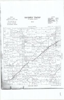
- Made by Katherine Stevens. Title in lower right corner: Plat #7, Van Buren Twp. Shows roads, creeks, churches, cemeteries, schools, and owner names with acre...
- Call Number:
- G4093.M7G46 1939 .S74 Van Buren
- Caption:
- Imprint: Bloomington, Indiana : Katherine Stevens, [1939]
- Physical Description:
- Dimensions: on sheet 92 x 59 cm and Scale: Approximately 1:18,000. 1,500 feet = 1 inch
- Alternate Identifier:
- Title Control Number: a18408348
- Persistent URL:
- https://purl.dlib.indiana.edu/iudl/images/VAC3073/VAC3073-M-01526
- Provenance:
- Katherine Stevens. Township maps of Monroe County, Indiana, [1939]
-
- Subject:
- Topical Subject: Real property, Geographic Subject: Washington (Monroe County, Ind. : Township), and Topical Subject: Landowners
- Creator:
- Stevens, Katherine (Mapmaker)
- Publisher:
- Stevens, Katherine (Mapmaker)
- Date Created:
- 1939
- Identifier:
- VAC3073-M-01525
- Genre:
- Cadastral maps
- Geographic Location:
- Coordinates: W0863534 W0862752 N0392013 N0391503
- Related URL:
- Catalog URL: https://iucat.iu.edu/catalog/18408369
- Abstract:
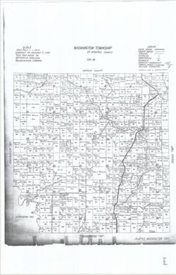
- Made by Katherine Stevens. Title in lower right corner: Plat #2, Washington Twp. Shows roads, creeks, churches, cemeteries, schools, and owner names with acr...
- Call Number:
- G4093.M7G46 1939 .S74 Washington
- Caption:
- Imprint: Bloomington, Indiana : Katherine Stevens, [1939]
- Physical Description:
- Scale: Approximately 1:18,000. 1,500 feet = 1 inch and Dimensions: on sheet 92 x 59 cm
- Alternate Identifier:
- Title Control Number: a18408369
- Persistent URL:
- https://purl.dlib.indiana.edu/iudl/images/VAC3073/VAC3073-M-01525
- Provenance:
- Katherine Stevens. Township maps of Monroe County, Indiana, [1939]
-
- Subject:
- Geographic Subject: Indian Creek (Monroe County, Ind. : Township), Topical Subject: Landowners, and Topical Subject: Real property
- Creator:
- Stevens, Katherine (Mapmaker)
- Publisher:
- Stevens, Katherine (Mapmaker)
- Date Created:
- 1939
- Identifier:
- VAC3073-M-01523
- Genre:
- Cadastral maps
- Geographic Location:
- Coordinates: W0864107 W0863423 N0390445 N0385938
- Related URL:
- Catalog URL: https://iucat.iu.edu/catalog/18409333
- Abstract:
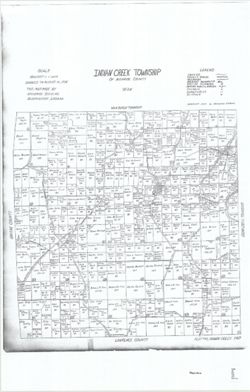
- Made by Katherine Stevens. Title in lower right corner: Plat #10, Indian Creek Twp. Shows roads, creeks, railroads, churches, cemeteries, schools, and owner ...
- Call Number:
- G4093.M7G46 1939 .S74 Indian Creek
- Caption:
- Imprint: Bloomington, Indiana : Katherine Stevens, [1939]
- Physical Description:
- Dimensions: on sheet 92 x 59 cm and Scale: Approximately 1:18,000. 1,500 feet = 1 inch
- Alternate Identifier:
- Title Control Number: a18409333
- Persistent URL:
- https://purl.dlib.indiana.edu/iudl/images/VAC3073/VAC3073-M-01523
- Provenance:
- Katherine Stevens. Township maps of Monroe County, Indiana, [1939]
-
- Subject:
- Topical Subject: Real property, Topical Subject: Landowners, and Geographic Subject: Bloomington (Monroe County, Ind. : Township)
- Creator:
- Stevens, Katherine (Mapmaker)
- Publisher:
- Stevens, Katherine (Mapmaker)
- Date Created:
- 1939
- Identifier:
- VAC3073-M-01524
- Genre:
- Cadastral maps
- Geographic Location:
- Coordinates: W0863425 W0862735 N0391636 N0390950
- Related URL:
- Catalog URL: https://iucat.iu.edu/catalog/18408240
- Abstract:
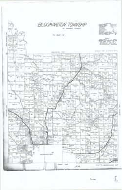
- Made by Katherine Stevens. Title in lower right corner: Plat #5, Bloomington Twp. Shows roads, creeks, railroads, churches, cemeteries, schools, and owner na...
- Call Number:
- G4093.M7G46 1939 .S74 Bloomington
- Caption:
- Imprint: Bloomington, Indiana : Katherine Stevens, [1939]
- Physical Description:
- Dimensions: on sheet 92 x 59 cm and Scale: Approximately 1:18,000. 1,500 feet = 1 inch
- Alternate Identifier:
- Title Control Number: a18408240
- Persistent URL:
- https://purl.dlib.indiana.edu/iudl/images/VAC3073/VAC3073-M-01524
- Provenance:
- Katherine Stevens. Township maps of Monroe County, Indiana, [1939]
-
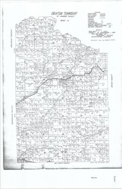
- Subject:
- Geographic Subject: Benton (Monroe County, Ind. : Township), Topical Subject: Real property, and Topical Subject: Landowners
- Creator:
- Stevens, Katherine (Mapmaker)
- Publisher:
- Stevens, Katherine (Mapmaker)
- Date Created:
- 1939
- Identifier:
- VAC3073-M-01522
- Genre:
- Cadastral maps
- Geographic Location:
- Coordinates: W0862745 W0862213 N0392024 N0391624
- Related URL:
- Catalog URL: https://iucat.iu.edu/catalog/18409337
- Abstract:
- Made by Katherine Stevens. Title in lower right corner: Plat #6, Benton Twp. Shows roads, creeks, railroads, churches, cemeteries, schools, and owner names w...
- Call Number:
- G4093.M7G46 1939 .S74 Benton
- Caption:
- Imprint: Bloomington, Indiana : Katherine Stevens, [1939]
- Physical Description:
- Dimensions: on sheet 92 x 59 cm and Scale: Approximately 1:18,000. 1,500 feet = 1 inch
- Alternate Identifier:
- Title Control Number: a18409337
- Persistent URL:
- https://purl.dlib.indiana.edu/iudl/images/VAC3073/VAC3073-M-01522
- Provenance:
- Katherine Stevens. Township maps of Monroe County, Indiana, [1939]
-
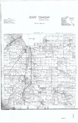
- Subject:
- Geographic Subject: Perry (Monroe County, Ind. : Township), Topical Subject: Real property, and Topical Subject: Landowners
- Creator:
- Stevens, Katherine (Mapmaker)
- Publisher:
- Stevens, Katherine (Mapmaker)
- Date Created:
- 1939
- Identifier:
- VAC3073-M-01521
- Genre:
- Cadastral maps
- Geographic Location:
- Coordinates: W0863423 W0862741 N0390952 N0390531
- Related URL:
- Catalog URL: https://iucat.iu.edu/catalog/18409336
- Abstract:
- Made by Katherine Stevens. Title in lower right corner: Plat #8, Perry Twp. Shows roads, creeks, railroads, churches, cemeteries, schools, and owner names wi...
- Call Number:
- G4093.M7G46 1939 .S74 Perry
- Caption:
- Imprint: Bloomington, Indiana : Katherine Stevens, [1939]
- Physical Description:
- Scale: Approximately 1:18,000. 1,500 feet = 1 inch and Dimensions: on sheet 92 x 59 cm
- Alternate Identifier:
- Title Control Number: a18409336
- Persistent URL:
- https://purl.dlib.indiana.edu/iudl/images/VAC3073/VAC3073-M-01521
- Provenance:
- Katherine Stevens. Township maps of Monroe County, Indiana, [1939]
-
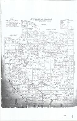
- Subject:
- Topical Subject: Real property, Topical Subject: Landowners, and Geographic Subject: Bean Blossom (Monroe County, Ind. : Township)
- Creator:
- Stevens, Katherine (Mapmaker)
- Publisher:
- Stevens, Katherine (Mapmaker)
- Date Created:
- 1939
- Identifier:
- VAC3073-M-01520
- Genre:
- Cadastral maps
- Geographic Location:
- Coordinates: W0864107 W0863429 N0392125 N0391505
- Related URL:
- Catalog URL: https://iucat.iu.edu/catalog/18408228
- Abstract:
- Made by Katherine Stevens. Title in lower right corner: Plat #1, Bean Blossom Twp. Shows roads, creeks, railroads, churches, cemeteries, schools, and owner n...
- Call Number:
- G4093.M7G46 1939 .S74 Bean Blossom
- Caption:
- Imprint: Bloomington, Indiana : Katherine Stevens, [1939]
- Physical Description:
- Scale: Approximately 1:18,000. 1,500 feet = 1 inch and Dimensions: on sheet 92 x 59 cm
- Alternate Identifier:
- Title Control Number: a18408228
- Persistent URL:
- https://purl.dlib.indiana.edu/iudl/images/VAC3073/VAC3073-M-01520
- Provenance:
- Katherine Stevens. Township maps of Monroe County, Indiana, [1939]
-
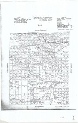
- Subject:
- Topical Subject: Real property, Topical Subject: Landowners, and Geographic Subject: Salt Creek (Monroe County, Ind. : Township)
- Creator:
- Stevens, Katherine (Mapmaker)
- Publisher:
- Stevens, Katherine (Mapmaker)
- Date Created:
- 1939
- Identifier:
- VAC3073-M-01519
- Genre:
- Cadastral maps
- Geographic Location:
- Coordinates: W0862738 W0862209 N0390953 N0390440
- Related URL:
- Catalog URL: https://iucat.iu.edu/catalog/18408344
- Abstract:
- Made by Katherine Stevens. Title in lower right corner: Plat #9, Salt Creek Twp. Shows roads, creeks, churches, cemeteries, schools, and owner names with acr...
- Call Number:
- G4093.M7G46 1939 .S74 Salt Creek
- Caption:
- Imprint: Bloomington, Indiana : Katherine Stevens, [1939]
- Physical Description:
- Scale: 1:18,000. 1,500 feet = 1 inch and Dimensions: on sheet 92 x 59 cm
- Alternate Identifier:
- Title Control Number: a18408344
- Persistent URL:
- https://purl.dlib.indiana.edu/iudl/images/VAC3073/VAC3073-M-01519
- Provenance:
- Katherine Stevens. Township maps of Monroe County, Indiana, [1939]
-
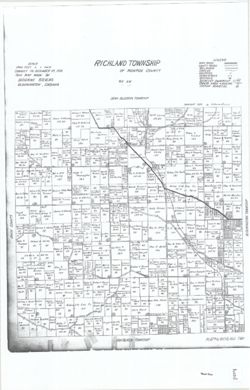
- Subject:
- Geographic Subject: Richland (Monroe County, Ind. : Township), Topical Subject: Real property, and Topical Subject: Landowners
- Creator:
- Stevens, Katherine (Mapmaker)
- Publisher:
- Stevens, Katherine (Mapmaker)
- Date Created:
- 1939
- Identifier:
- VAC3073-M-01518
- Genre:
- Cadastral maps
- Geographic Location:
- Coordinates: W0864102 W0863423 N0391509 N0390951
- Related URL:
- Catalog URL: https://iucat.iu.edu/catalog/18409340
- Abstract:
- Made by Katherine Stevens. Title in lower right corner: Plat #4, Richland Twp. Shows roads, creeks, railroads, churches, cemeteries, schools, and owner names...
- Call Number:
- G4093.M7G46 1939 .S74 Richland
- Caption:
- Imprint: Bloomington, Indiana : Katherine Stevens, [1939]
- Physical Description:
- Dimensions: on sheet 92 x 59 cm and Scale: Approximately 1:18,000. 1,500 feet = 1 inch
- Alternate Identifier:
- Title Control Number: a18409340
- Persistent URL:
- https://purl.dlib.indiana.edu/iudl/images/VAC3073/VAC3073-M-01518
- Provenance:
- Katherine Stevens. Township maps of Monroe County, Indiana, [1939]
-
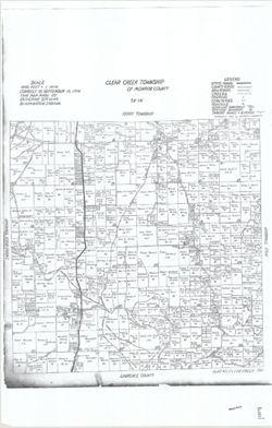
- Subject:
- Topical Subject: Landowners, Geographic Subject: Clear Creek (Monroe County, Ind. : Township), and Topical Subject: Real property
- Creator:
- Stevens, Katherine (Mapmaker)
- Publisher:
- Stevens, Katherine (Mapmaker)
- Date Created:
- 1939
- Identifier:
- VAC3073-M-01517
- Genre:
- Cadastral maps
- Geographic Location:
- Coordinates: W0863409 W0862740 N0390438 N0385938
- Related URL:
- Catalog URL: https://iucat.iu.edu/catalog/18409339
- Abstract:
- Made by Katherine Stevens. Title in lower right corner: Plat #11, Clear Creek Twp. Shows roads, creeks, railroads, churches, cemeteries, schools, and owner n...
- Call Number:
- G4093.M7G46 1939 .S74 Clear Creek
- Caption:
- Imprint: Bloomington, Indiana : Katherine Stevens, [1939]
- Physical Description:
- Scale: 1:18,000. 1,500 feet = 1 inch and Dimensions: on sheet 92 x 59 cm
- Alternate Identifier:
- Title Control Number: a18409339
- Persistent URL:
- https://purl.dlib.indiana.edu/iudl/images/VAC3073/VAC3073-M-01517
- Provenance:
- Katherine Stevens. Township maps of Monroe County, Indiana, [1939]
