
Search Constraints
« Previous |
1 - 10 of 30
|
Next »
Search Results
-
- Description:
- 1926
- Subject:
- Topical Subject: Soviet Union, Topical Subject: Maps, and Geographic Subject: Mohács
- Publisher:
- Генеральный штаб Красной Армии
- Language:
- Russian
- Date Created:
- 1944
- Identifier:
- VAC9619-001479
- Genre:
- Topographic Maps and Military Maps
- Geographic Location:
- Coordinates: 45.6667, 18.5, 46, 19
- Related URL:
- DataCORE Dataset Download: https://datacore.iu.edu/concern/data_sets/cv43nx57x
- Abstract:
- Modern area represented: Mohács, Baranya county, Hungary
- Call Number:
- G7000 s100 .S7 sheet L-34-74
- City:
- Мохач (Mohács)
- Copyright Holder:
- No Copyright - United States
- Country:
- Югославия (Yugoslavia) and Венгрия (Hungary)
- Physical Description:
- Scale: 1:100,000
- Persistent URL:
- http://purl.dlib.indiana.edu/iudl/images/VAC9619/VAC9619-001479
- Provenance:
- DMA Topographic Center, Army Map Service Library, OMAHA, Atlasblatt, Library of Congress Geography & Map Division
-
- Description:
- 1894
- Subject:
- Topical Subject: Soviet Union, Geographic Subject: Szekszárd, and Topical Subject: Maps
- Publisher:
- Генеральный штаб Красной Армии
- Language:
- Russian
- Date Created:
- 1944
- Identifier:
- VAC9619-001477
- Genre:
- Military Maps and Topographic Maps
- Geographic Location:
- Coordinates: 46.3333, 18.5, 46.6667, 19
- Related URL:
- DataCORE Dataset Download: https://datacore.iu.edu/concern/data_sets/s1784m509
- Abstract:
- Modern area represented: Szekszárd, Tolna county, Hungary
- Call Number:
- G7000 s100 .S7 sheet L-34-50
- City:
- Сексард (Szekszárd)
- Copyright Holder:
- No Copyright - United States
- Country:
- Венгрия (Hungary)
- Physical Description:
- Scale: 1:100,000
- Persistent URL:
- http://purl.dlib.indiana.edu/iudl/images/VAC9619/VAC9619-001477
- Provenance:
- DMA Topographic Center, Army Map Service Library, OMAHA, Atlasblatt, Library of Congress Geography & Map Division
-
- Description:
- 1940
- Subject:
- Geographic Subject: Berezhany, Topical Subject: Soviet Union, and Topical Subject: Maps
- Publisher:
- Генеральный штаб Красной Армии
- Language:
- Russian
- Date Created:
- 1944
- Identifier:
- VAC9619-003228
- Genre:
- Topographic Maps and Military Maps
- Geographic Location:
- Coordinates: 49.333, 24.5, 49.667, 25
- Related URL:
- DataCORE Dataset Download: https://datacore.iu.edu/concern/data_sets/rx913q600
- Abstract:
- Modern area represented: Berezhany, Ternopil oblast, Ukraine
- Call Number:
- G7000 s100 .S7 sheet M-35-86
- Caption:
- Для служебного пользования
- City:
- Бережаны (Berezhany)
- Copyright Holder:
- No Copyright - United States
- Country:
- СССР (USSR)
- State/Province:
- Тернопольская область (Ternopil oblast), Украинская ССР (Ukrainian Soviet Socialist Republic), Станиславская область (Stanislav oblast), and Львовская област...
- Physical Description:
- Scale: 1:100,000
- Persistent URL:
- http://purl.dlib.indiana.edu/iudl/images/VAC9619/VAC9619-003228
- Provenance:
- DMA Topographic Center, Army Map Service Library, OMAHA, Geographic Names Branch
-
- Description:
- 1940
- Subject:
- Geographic Subject: Khodoriv, Topical Subject: Maps, and Topical Subject: Soviet Union
- Publisher:
- Генеральный штаб Красной Армии
- Language:
- Russian
- Date Created:
- 1944
- Identifier:
- VAC9619-003227
- Genre:
- Military Maps and Topographic Maps
- Geographic Location:
- Coordinates: 49.333, 24, 49.667, 24.5
- Related URL:
- DataCORE Dataset Download: https://datacore.iu.edu/concern/data_sets/5d86p106z
- Abstract:
- Modern area represented: Khodoriv, Lviv oblast, Ukraine
- Call Number:
- G7000 s100 .S7 sheet M-35-85
- Caption:
- Для служебного пользования
- City:
- Ходоров (Khodoriv)
- Copyright Holder:
- No Copyright - United States
- Country:
- СССР (USSR)
- State/Province:
- Львовская область (Lviv oblast), Станиславская область (Stanislav oblast), Украинская ССР (Ukrainian Soviet Socialist Republic), and Дрогобычская область (Dr...
- Physical Description:
- Scale: 1:100,000
- Persistent URL:
- http://purl.dlib.indiana.edu/iudl/images/VAC9619/VAC9619-003227
- Provenance:
- DMA Topographic Center, Army Map Service Library, OMAHA, Geographic Names Branch
-
- Description:
- 1940
- Subject:
- Geographic Subject: Yavoriv, Topical Subject: Soviet Union, and Topical Subject: Maps
- Publisher:
- Генеральный штаб Красной Армии
- Language:
- Russian
- Date Created:
- 1944
- Identifier:
- VAC9619-003017
- Genre:
- Topographic Maps and Military Maps
- Geographic Location:
- Coordinates: 49.667, 23, 50, 23.5
- Related URL:
- DataCORE Dataset Download: https://datacore.iu.edu/concern/data_sets/1544bp90c
- Abstract:
- Modern area represented: Yavoriv, Lviv oblast, Ukraine
- Call Number:
- G7000 s100 .S7 sheet M-34-83
- Caption:
- Для служебного пользования
- City:
- Яворов (Yavoriv)
- Copyright Holder:
- No Copyright - United States
- Country:
- СССР (USSR)
- State/Province:
- Украинская ССР (Ukrainian Soviet Socialist Republic), Дрогобычская область (Drohobych oblast), and Львовская область (Lviv oblast)
- Physical Description:
- Scale: 1:100,000
- Persistent URL:
- http://purl.dlib.indiana.edu/iudl/images/VAC9619/VAC9619-003017
- Provenance:
- DMA Topographic Center, Army Map Service Library, OMAHA
-

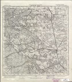
- Description:
- 1874
- Subject:
- Topical Subject: Soviet Union, Topical Subject: Maps, and Geographic Subject: Horodok
- Publisher:
- Генеральный штаб Красной Армии
- Language:
- Russian
- Date Created:
- 1944
- Identifier:
- VAC9619-003019
- Genre:
- Military Maps and Topographic Maps
- Geographic Location:
- Coordinates: 49.667, 23.5, 50, 24
- Related URL:
- DataCORE Dataset Download: https://datacore.iu.edu/concern/data_sets/h702q733w
- Abstract:
- Modern area represented: Horodok, Lviv oblast, Ukraine
- Call Number:
- G7000 s100 .S7 sheet M-34-84
- Caption:
- Для служебного пользования
- City:
- Грудек Ягельоньски (Gródek Jagielloński)
- Copyright Holder:
- No Copyright - United States
- Country:
- СССР (USSR)
- State/Province:
- Львовская область (Lviv oblast) and Украинская ССР (Ukrainian Soviet Socialist Republic)
- Physical Description:
- Scale: 1:100,000
- Persistent URL:
- http://purl.dlib.indiana.edu/iudl/images/VAC9619/VAC9619-003019
- Provenance:
- DMA Topographic Center, Army Map Service Library, OMAHA
-
- Description:
- 1934
- Subject:
- Geographic Subject: Tomaszów Lubelski, Topical Subject: Soviet Union, and Topical Subject: Maps
- Publisher:
- Генеральный штаб Красной Армии
- Language:
- Russian
- Date Created:
- 1944
- Identifier:
- VAC9619-002859
- Genre:
- Military Maps and Topographic Maps
- Geographic Location:
- Coordinates: 50.333, 23, 50.667, 23.5
- Related URL:
- DataCORE Dataset Download: https://datacore.iu.edu/concern/data_sets/pr76f413w
- Abstract:
- Modern area represented: Tomaszów Lubelski, Lublin province, Poland
- Call Number:
- G7000 s100 .S7 sheet M-34-59
- City:
- Томашув (Tomaszów)
- Copyright Holder:
- No Copyright - United States
- Country:
- СССР (USSR) and Польша (Poland)
- State/Province:
- Львовская область (Lviv oblast) and Украинская ССР (Ukrainian Soviet Socialist Republic)
- Physical Description:
- Scale: 1:100,000
- Persistent URL:
- http://purl.dlib.indiana.edu/iudl/images/VAC9619/VAC9619-002859
- Provenance:
- CIA Map Library
-
- Description:
- 1929
- Subject:
- Topical Subject: Maps, Topical Subject: Soviet Union, and Geographic Subject: Sombor
- Publisher:
- Генеральный штаб Красной Армии
- Language:
- Russian
- Date Created:
- 1944
- Identifier:
- VAC9619-001000
- Genre:
- Topographic Maps and Military Maps
- Geographic Location:
- Coordinates: 45.6667, 19, 46, 19.5
- Related URL:
- DataCORE Dataset Download: https://datacore.iu.edu/concern/data_sets/4t64gn82s
- Abstract:
- Modern area represented: Sombor, Vojvodina province, Serbia
- Call Number:
- G7000 s100 .S7 sheet L-34-75
- City:
- Сомбор (Sombor)
- Copyright Holder:
- No Copyright - United States
- Country:
- Югославия (Yugoslavia) and Венгрия (Hungary)
- Physical Description:
- Scale: 1:100,000
- Persistent URL:
- http://purl.dlib.indiana.edu/iudl/images/VAC9619/VAC9619-001000
- Provenance:
- DMA Topographic Center, Army Map Service Library, Library of Congress Geography & Map Division, Atlasblatt
-
- Description:
- 1880
- Subject:
- Topical Subject: Soviet Union, Topical Subject: Maps, and Geographic Subject: Lake Balaton
- Publisher:
- Генеральный штаб Красной Армии
- Language:
- Russian
- Date Created:
- 1944
- Identifier:
- VAC9619-000792
- Genre:
- Military Maps and Topographic Maps
- Geographic Location:
- Coordinates: 46.6667, 17.5, 47, 18
- Related URL:
- DataCORE Dataset Download: https://datacore.iu.edu/concern/data_sets/9p290b049
- Abstract:
- Modern area represented: Lake Balaton, Hungary
- Call Number:
- G7000 s100 .S7 sheet L-33-48
- City:
- Оз. Балатон (Lake Balaton)
- Copyright Holder:
- No Copyright - United States
- Country:
- Венгрия (Hungary)
- Physical Description:
- Scale: 1:100,000
- Persistent URL:
- http://purl.dlib.indiana.edu/iudl/images/VAC9619/VAC9619-000792
- Provenance:
- DMA Topographic Center, Army Map Service Library, OMAHA, Library of Congress Geography & Map Division, Atlasblatt
-
![Indiana-Illinois, Vincennes quadrangle : topography [1944 printing without vegetation]](https://iiif.uits.iu.edu/iiif/2/5425mf004%2Ffiles%2Fed25173c-f2ac-49e5-986c-99cf4220f9c3/full/250,/0/default.jpg)
- Subject:
- Geographic Subject: Gibson County (Ind.), Geographic Subject: Wabash County (Ill.), Geographic Subject: Lawrence County (Ill.), and Geographic Subject: Knox ...
- Creator:
- Marshall, R. B. (Robert Bradford), 1867-1949, Geological Survey (U.S.), Tweedy, Frank, 1854-1937, United States. Army. Corps of Engineers, Illinois State Geo...
- Publisher:
- Geological Survey (U.S.)
- Date Created:
- 1944
- Identifier:
- VAC3073-M-01508
- Genre:
- Topographic maps, 15 minute topographic maps, and Quadrangle maps
- Geographic Location:
- Coordinates: W0874500 W0873000 N0384500 N0383000
- Related URL:
- Catalog URL: https://iucat.iu.edu/catalog/18415517
- Abstract:
- R.B. Marshall, chief geographer , W.H. Herron, geographer in charge , topography by Frank Tweedy, C.L. Sadler, Chas. Hartmann, Jr., L.L. Lee, W.S. Gehres, an...
- Call Number:
- G4090 s62 .G4 Vincennes 1944
- Caption:
- Imprint: [Washington, D.C.] : U.S. Geological Survey, 1944.
- Physical Description:
- Scale: 1:62,500 and Dimensions: 45 x 42 cm or smaller
- Alternate Identifier:
- Title Control Number: a18415517
- Persistent URL:
- https://purl.dlib.indiana.edu/iudl/images/VAC3073/VAC3073-M-01508
- Provenance:
- Part of Geological Survey (U.S.). Indiana 1:62,500.

- « Previous
- Next »
- 1
- 2
- 3