
Search Constraints
You searched for:
Holding Location
B-WELLS
Remove constraint Holding Location: B-WELLS
Provenance
Army Map Service Library, OMAHA, Library of Congress Geography & Map Division
Remove constraint Provenance: Army Map Service Library, OMAHA, Library of Congress Geography & Map Division
Publisher
Главное управление государственной съемки и картографии НКВД СССР
Remove constraint Publisher: Главное управление государственной съемки и картографии НКВД СССР
« Previous |
1 - 10 of 24
|
Next »
Search Results
-
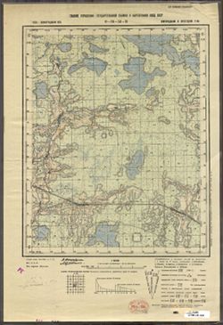
- Description:
- 1938
- Subject:
- Topical Subject: Maps, Geographic Subject: Zaytsevo, and Topical Subject: Soviet Union
- Publisher:
- Главное управление государственной съемки и картографии НКВД СССР
- Language:
- Russian
- Identifier:
- VAC9619-003372
- Genre:
- Topographic Maps and Military Maps
- Geographic Location:
- Coordinates: 58.333, 32, 58.5, 32.25
- Related URL:
- DataCORE Dataset Download: https://datacore.iu.edu/concern/data_sets/3197xm836
- Abstract:
- Modern area represented: Дворищи (Dvorishchi), Novgorodskaya oblast, Russia
- Call Number:
- G7000 s50 .S68 sheet O-36-53-C
- Caption:
- Для служебного пользования
- City:
- Зайцево (Zaytsevo)
- Copyright Holder:
- No Copyright - United States
- Country:
- СССР (USSR)
- State/Province:
- Крестецкий район (Krestetsky district), Новгородский район (Novgorod district), and Ленинградская область (Leningrad oblast)
- Physical Description:
- Scale: 1:50,000
- Persistent URL:
- http://purl.dlib.indiana.edu/iudl/images/VAC9619/VAC9619-003372
- Provenance:
- Army Map Service Library, OMAHA, Library of Congress Geography & Map Division
-
- Description:
- 1937
- Subject:
- Geographic Subject: Ostrov, Topical Subject: Maps, and Topical Subject: Soviet Union
- Publisher:
- Главное управление государственной съемки и картографии НКВД СССР
- Language:
- Russian
- Identifier:
- VAC9619-003362
- Genre:
- Military Maps and Topographic Maps
- Geographic Location:
- Coordinates: 58.5, 30.5, 58.667, 30.75
- Related URL:
- DataCORE Dataset Download: https://datacore.iu.edu/concern/data_sets/pz50gw814
- Abstract:
- Modern area represented: Остров (Ostrov), Novgorodskaya oblast, Russia
- Call Number:
- G7000 s50 .S68 sheet O-36-50-A
- Caption:
- Для служебного пользования
- City:
- Остров (Ostrov)
- Copyright Holder:
- No Copyright - United States
- Country:
- СССР (USSR)
- State/Province:
- Батецкий район (Batetsky district), Ленинградская область (Leningrad oblast), РСФСР (RSFSR), and Новгородский район (Novgorod district)
- Physical Description:
- Scale: 1:50,000
- Persistent URL:
- http://purl.dlib.indiana.edu/iudl/images/VAC9619/VAC9619-003362
- Provenance:
- Army Map Service Library, OMAHA, Library of Congress Geography & Map Division
-
- Description:
- 1936
- Subject:
- Topical Subject: Soviet Union, Topical Subject: Maps, and Geographic Subject: Burga
- Publisher:
- Главное управление государственной съемки и картографии НКВД СССР
- Language:
- Russian
- Date Created:
- 1941
- Identifier:
- VAC9619-003353
- Genre:
- Military Maps and Topographic Maps
- Geographic Location:
- Coordinates: 58.667, 32.25, 58.833, 32.5
- Related URL:
- DataCORE Dataset Download: https://datacore.iu.edu/concern/data_sets/8c97kr126
- Abstract:
- Modern area represented: Бурга (Burga), Novgorodskaya oblast, Russia
- Call Number:
- G7000 s50 .S68 sheet O-36-41-D
- Caption:
- Captured map and Для служебного пользования
- City:
- Бурга (Burga)
- Copyright Holder:
- No Copyright - United States
- Country:
- СССР (USSR)
- State/Province:
- РСФСР (RSFSR), Ленинградская область (Leningrad oblast), and Маловишерский район (Malovishersky district)
- Physical Description:
- Scale: 1:50,000
- Persistent URL:
- http://purl.dlib.indiana.edu/iudl/images/VAC9619/VAC9619-003353
- Provenance:
- Army Map Service Library, OMAHA, Library of Congress Geography & Map Division
-
- Description:
- 1936
- Subject:
- Topical Subject: Soviet Union, Topical Subject: Maps, and Geographic Subject: Glutno
- Publisher:
- Главное управление государственной съемки и картографии НКВД СССР
- Language:
- Russian
- Date Created:
- 1941
- Identifier:
- VAC9619-003352
- Genre:
- Military Maps and Topographic Maps
- Geographic Location:
- Coordinates: 58.667, 32, 58.833, 32.25
- Related URL:
- DataCORE Dataset Download: https://datacore.iu.edu/concern/data_sets/sq87bv43q
- Abstract:
- Modern area represented: Глутно (Glutno), Novgorodskaya oblast, Russia
- Call Number:
- G7000 s50 .S68 sheet O-36-41-C
- Caption:
- Для служебного пользования and Captured map
- City:
- Глутно (Glutno)
- Copyright Holder:
- No Copyright - United States
- Country:
- СССР (USSR)
- State/Province:
- Маловишерский район (Malovishersky district), РСФСР (RSFSR), and Ленинградская область (Leningrad oblast)
- Physical Description:
- Scale: 1:50,000
- Persistent URL:
- http://purl.dlib.indiana.edu/iudl/images/VAC9619/VAC9619-003352
- Provenance:
- Army Map Service Library, OMAHA, Library of Congress Geography & Map Division
-
- Description:
- 1936
- Subject:
- Topical Subject: Maps, Geographic Subject: Pustaya Visherka, and Topical Subject: Soviet Union
- Publisher:
- Главное управление государственной съемки и картографии НКВД СССР
- Language:
- Russian
- Date Created:
- 1941
- Identifier:
- VAC9619-003351
- Genre:
- Military Maps and Topographic Maps
- Geographic Location:
- Coordinates: 58.833, 32.25, 59, 32.5
- Related URL:
- DataCORE Dataset Download: https://datacore.iu.edu/concern/data_sets/f7623d519
- Abstract:
- Modern area represented: Пустая Вишерка (Pustaya Visherka), Novgorodskaya oblast, Russia
- Call Number:
- G7000 s50 .S68 sheet O-36-41-B
- Caption:
- Captured map and Для служебного пользования
- City:
- Пустая Вишерка (Pustaya Visherka)
- Copyright Holder:
- No Copyright - United States
- Country:
- СССР (USSR)
- State/Province:
- Ленинградская область (Leningrad oblast), Маловишерский район (Malovishersky district), and РСФСР (RSFSR)
- Physical Description:
- Scale: 1:50,000
- Persistent URL:
- http://purl.dlib.indiana.edu/iudl/images/VAC9619/VAC9619-003351
- Provenance:
- Army Map Service Library, OMAHA, Library of Congress Geography & Map Division
-
- Description:
- 1936
- Subject:
- Topical Subject: Soviet Union, Topical Subject: Maps, and Geographic Subject: Malaya Vishera
- Publisher:
- Главное управление государственной съемки и картографии НКВД СССР
- Language:
- Russian
- Identifier:
- VAC9619-003350
- Genre:
- Topographic Maps and Military Maps
- Geographic Location:
- Coordinates: 58.833, 32, 59, 32.5
- Related URL:
- DataCORE Dataset Download: https://datacore.iu.edu/concern/data_sets/pc289j891
- Abstract:
- Modern area represented: Малая Вишера (Malaya Vishera), Novgorodskaya oblast, Russia
- Call Number:
- G7000 s50 .S68 sheet O-36-41-A
- Caption:
- Для служебного пользования and Captured map
- City:
- Малая Вишера (Malaya Vishera)
- Copyright Holder:
- No Copyright - United States
- Country:
- СССР (USSR)
- State/Province:
- Маловишерский район (Malovishersky district), Ленинградская область (Leningrad oblast), and РСФСР (RSFSR)
- Physical Description:
- Scale: 1:50,000
- Persistent URL:
- http://purl.dlib.indiana.edu/iudl/images/VAC9619/VAC9619-003350
- Provenance:
- Army Map Service Library, OMAHA, Library of Congress Geography & Map Division
-
- Description:
- 1937
- Subject:
- Topical Subject: Soviet Union, Topical Subject: Maps, and Geographic Subject: Zmeysko
- Publisher:
- Главное управление государственной съемки и картографии НКВД СССР
- Language:
- Russian
- Identifier:
- VAC9619-003348
- Genre:
- Military Maps and Topographic Maps
- Geographic Location:
- Coordinates: 58.667, 31.5, 58.833, 31.75
- Related URL:
- DataCORE Dataset Download: https://datacore.iu.edu/concern/data_sets/f1881m77z
- Abstract:
- Modern area represented: Змейско (Zmeysko), Novgorodskaya oblast, Russia
- Call Number:
- G7000 s50 .S68 sheet O-36-40-C
- Caption:
- Для служебного пользования
- City:
- Змейско (Zmeysko)
- Copyright Holder:
- No Copyright - United States
- Country:
- СССР (USSR)
- State/Province:
- Ленинградская область (Leningrad oblast), Новгородский район (Novgorod district), Маловишерский район (Malovishersky district), and РСФСР (RSFSR)
- Physical Description:
- Scale: 1:50,000
- Persistent URL:
- http://purl.dlib.indiana.edu/iudl/images/VAC9619/VAC9619-003348
- Provenance:
- Army Map Service Library, OMAHA, Library of Congress Geography & Map Division
-
- Description:
- 1937
- Subject:
- Geographic Subject: Gryady, Topical Subject: Soviet Union, and Topical Subject: Maps
- Publisher:
- Главное управление государственной съемки и картографии НКВД СССР
- Language:
- Russian
- Date Created:
- 1941
- Identifier:
- VAC9619-003347
- Genre:
- Military Maps and Topographic Maps
- Geographic Location:
- Coordinates: 58.8333, 31.75, 59.0, 32.0
- Related URL:
- DataCORE Dataset Download: https://datacore.iu.edu/concern/data_sets/t148fj174
- Abstract:
- Modern area represented: Гряды (Gryady), Novgorodskaya oblast, Russia
- Call Number:
- G7000 s50 .S68 sheet O-36-40-B
- Caption:
- Captured map and Для служебного пользования
- City:
- Гряды (Gryady)
- Copyright Holder:
- No Copyright - United States
- Country:
- СССР (USSR)
- State/Province:
- Чудовский район (Chudovsky district), Ленинградская область (Leningrad oblast), Маловишерский район (Malovishersky district), and РСФСР (RSFSR)
- Physical Description:
- Scale: 1:50,000
- Persistent URL:
- http://purl.dlib.indiana.edu/iudl/images/VAC9619/VAC9619-003347
- Provenance:
- Army Map Service Library, OMAHA, Library of Congress Geography & Map Division
-
- Description:
- 1937
- Subject:
- Topical Subject: Soviet Union, Topical Subject: Maps, and Geographic Subject: Spasskaya Polist’
- Publisher:
- Главное управление государственной съемки и картографии НКВД СССР
- Language:
- Russian
- Identifier:
- VAC9619-003346
- Genre:
- Military Maps and Topographic Maps
- Geographic Location:
- Coordinates: 58.833, 31.5, 59, 31.75
- Related URL:
- DataCORE Dataset Download: https://datacore.iu.edu/concern/data_sets/5t34sk340
- Abstract:
- Modern area represented: Спасская Полисть (Spasskaya Polist’), Novgorodskaya oblast, Russia
- Call Number:
- G7000 s50 .S68 sheet O-36-40-A
- Caption:
- Captured map and Для служебного пользования
- City:
- Спасская Полисть (Spasskaya Polist’)
- Copyright Holder:
- No Copyright - United States
- Country:
- СССР (USSR)
- State/Province:
- Ленинградская область (Leningrad oblast), Новгородский район (Novgorod district), Чудовский район (Chudovsky district), and РСФСР (RSFSR)
- Physical Description:
- Scale: 1:50,000
- Persistent URL:
- http://purl.dlib.indiana.edu/iudl/images/VAC9619/VAC9619-003346
- Provenance:
- Army Map Service Library, OMAHA, Library of Congress Geography & Map Division
-
- Description:
- 1937
- Subject:
- Topical Subject: Soviet Union, Topical Subject: Maps, and Geographic Subject: Myasnoy Bor
- Publisher:
- Главное управление государственной съемки и картографии НКВД СССР
- Language:
- Russian
- Date Created:
- 1941
- Identifier:
- VAC9619-003345
- Genre:
- Military Maps and Topographic Maps
- Geographic Location:
- Coordinates: 58.667, 31.25, 58.833, 31.5
- Related URL:
- DataCORE Dataset Download: https://datacore.iu.edu/concern/data_sets/0v8381465
- Abstract:
- Modern area represented: Мясной Бор (Myasnoy Bor), Novgorodskaya oblast, Russia
- Call Number:
- G7000 s50 .S68 sheet O-36-39-D
- Caption:
- Для служебного пользования
- City:
- Мясной Бор (Myasnoy Bor)
- Copyright Holder:
- No Copyright - United States
- Country:
- СССР (USSR)
- State/Province:
- Ленинградская область (Leningrad oblast), Чудовский район (Chudovsky district), РСФСР (RSFSR), and Новгородский район (Novgorod district)
- Physical Description:
- Scale: 1:50,000
- Persistent URL:
- http://purl.dlib.indiana.edu/iudl/images/VAC9619/VAC9619-003345
- Provenance:
- Army Map Service Library, OMAHA, Library of Congress Geography & Map Division

- « Previous
- Next »
- 1
- 2
- 3