United States, Department of the Interior, Geological Survey , Jno. H. Renshawe, geographer in charge , control by U.S. Lake Survey , topography by R. C. McK...
Call Number:
G4090 s62 .G4 Toleston 1900 rep 1939
Caption:
Imprint: Washington, D. C. : United States, Department of the Interior, Geological Survey, 1939
Physical Description:
Dimensions: 45 x 42 cm or smaller and Scale: 1:62,500
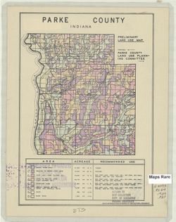
Geographic Subject: Parke County (Ind.) and Topical Subject: Land use
Creator:
Parke County (Ind.). Land Use Planning Committee
Publisher:
United States. Bureau of Agricultural Economics
Date Created:
1939
Identifier:
VAC3073-M-00689
Genre:
Thematic maps
Geographic Location:
Coordinates: W0872602 W0870034 N0395712 N0393617
Related URL:
Catalog URL: https://iucat.iu.edu/catalog/5126505
Abstract:
"Color reproduction by Bureau of Agricultural Economics, U.S.D.A." "3-30-39." Includes chart showing type of land use, acreage, and recom...
Call Number:
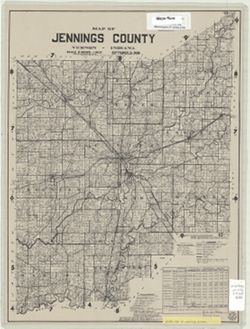
G4093.P2G4 1939 .P37
Caption:
Imprint: [Washington, D.C.?] : U.S. Bureau of Agricultural Economics, [1939]
Physical Description:
Dimensions: 17 x 16 cm, on sheet 28 x 22 cm and Scale: Scale not given.
Topical Subject: Real property, Geographic Subject: Jennings County (Ind.), and Topical Subject: Landowners
Creator:
Butler, Chas. T.
Publisher:
[Jennings County?]
Date Created:
1939
Identifier:
VAC3073-M-00385
Genre:
Cadastral maps
Geographic Location:
Coordinates: W0854800 W0852700 N0391200 N0385500
Related URL:
Catalog URL: https://iucat.iu.edu/catalog/5541213
Abstract:
Cadastral map showing landowners. Includes chart of "Jennings County statistics, 1930-1935, and lists of Board of County Commissioners, Board of County...

![Indiana (Lake County) Tolleston quadrangle [1939 reprint]](https://iiif.uits.iu.edu/iiif/2/cf95kf17p%2Ffiles%2F6cfc5093-ccb9-443c-8bd5-426984875407/full/250,/0/default.jpg)