


Limit your search
- Topical Subject: Maps49
- Topical Subject: Soviet Union49
- Geographic Subject: Indiana7
- Topical: Graves5
- Advertising --Motion pictures4
- Angel Mounds State Historic Site (Ind.)4
- Geographic Subject: Dubois County (Ind.)4
- Lantern slides --Specimens4
- Motion picture film4
- Geographic Subject: Pike County (Ind.)3
- more Subjects »
- 1936[remove]98
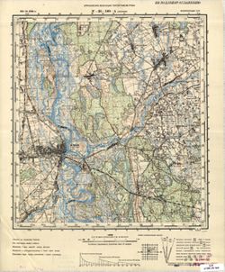
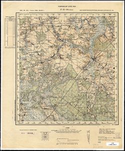
- Russian Military Topographic Map Collection49
- Indiana Historic Maps18
- Hoagy Carmichael Photograph Collection9
- Presidential Campaigns, A Cartoon History, 1789-19765
- Pauline Montgomery Indiana Tombstone Photographs5
- Glenn A. Black Laboratory of Archaeology Photographs5
- Ralston Lantern Slides4
- Roy W. Howard Photograph Collection3
- Белорусская ССР (Byelorussian Soviet Socialist Republic)23
- Indiana10
- Восточная Пруссия (East Prussia)10
- Область государственных интересов Германии (Region of German state interests)7
- Кенигсбергская провинция (Königsberg province)6
- Белостокская область (Belastok oblast)5
- РСФСР (RSFSR)5
- Алленштайнская провинция (Allenstein province)4
- Гумбинненская провинция (Gumbinnen province)3
- Брестская область (Brest oblast)2
- DMA Topographic Center, Army Map Service Library, OMAHA15
- DMA Topographic Center, Army Map Service Library14
- Part of Geological Survey (U.S.). Indiana 1:62,500.4
- DMA Topographic Center, Army Map Service Library, Auswärtiges Amt. Geographischer Dienst3
- Army Map Service Library, OMAHA, Library of Congress Geography & Map Division2
- DMA Topographic Center, Army Map Service Library, OMAHA, Library of Congress Geography & Map Division2
- Army Map Service Library, Auswärtiges Amt. Geographischer Dienst, OMAHA, Library of Congress Geography & Map Division1
- Army Map Service Library, Library of Congress G & M Division1
- Army Map Service Library, Library of Congress Geography & Map Division, OMAHA1
- CIA Map Branch -- Received1