
Search Constraints
You searched for:
Date Created
1901
Remove constraint Date Created: 1901
Publisher
Indiana. Department of Geology and Natural Resources
Remove constraint Publisher: Indiana. Department of Geology and Natural Resources
State
deposited
Remove constraint State: deposited
« Previous |
1 - 10 of 11
|
Next »
Search Results
-
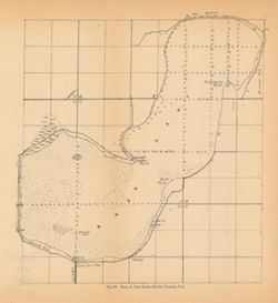
- Subject:
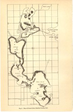
- Geographic Subject: James, Lake (Steuben County, Ind. : Lake), Topical Subject: Lakes, Topical Subject: IGS Annual Reports, Geographic Subject: Steuben Count...
- Publisher:
- Indiana. Department of Geology and Natural Resources
- Date Created:
- 1901
- Identifier:
- VAC3073-M-01178
- Genre:
- Thematic maps
- Geographic Location:
- Coordinates: W0850253 W0850033 N0414428 N0414050
- Related URL:
- Catalog URL: https://iucat.iu.edu/catalog/18190007
- Abstract:
- Depth shown by average depth range for each lake. Also shows information for Snow Lake and general locations of Mud Lake and Upper and Lower Otter Lakes. ...
- Call Number:
- G4092.J27 1900 .M37
- Caption:
- Imprint: [Indianapolis] : [Wm. B. Burford], [1901] and Imprint: [Indianapolis] : [Indiana, Department of Geology and Natural History], [1901]
- Physical Description:
- Dimensions: on sheet 23 x 15 cm and Scale: Approximately 1:32,000
- Alternate Identifier:
- Alternate ID: 390726IP and Title Control Number: a18190007
- Persistent URL:
- https://purl.dlib.indiana.edu/iudl/images/VAC3073/VAC3073-M-01178
- Provenance:
- 25th Annual Report (1900) / Indiana. Department of Geology and Natural Resources.
-
- Subject:
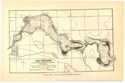
- Topical Subject: Lakes, Topical Subject: IGS Annual Reports, Geographic Subject: Tippecanoe, Lake (Ind.), and Geographic Subject: Kosciusko County (Ind.)
- Creator:
- Mase, Thomas L.
- Publisher:
- Indiana. Department of Geology and Natural Resources
- Date Created:
- 1901
- Identifier:
- VAC3073-M-01170
- Genre:
- Bathymetric maps
- Related URL:
- Catalog URL: https://iucat.iu.edu/catalog/4022271
- Call Number:
- QE109 .A2 1900 map p186
- Caption:
- Imprint: Indianapolis : Burford, 1901.
- Physical Description:
- Dimensions: 15 x 23 cm
- Persistent URL:
- https://purl.dlib.indiana.edu/iudl/images/VAC3073/VAC3073-M-01170
- Provenance:
- 25th Annual Report (1900) / Indiana. Department of Geology and Natural Resources.
-
- Subject:
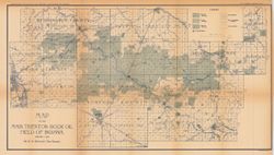
- Topical Subject: Oil fields and Geographic Subject: Indiana
- Creator:
- Blatchley, W. S. (Willis Stanley), 1859-1940
- Publisher:
- Indiana. Department of Geology and Natural Resources
- Date Created:
- 1901
- Identifier:
- VAC3073-M-01067
- Genre:
- Geological maps
- Geographic Location:
- Coordinates: W0854030 W0844820 N0404500 N0402200
- Related URL:
- Catalog URL: https://iucat.iu.edu/catalog/16078449
- Abstract:
- "January 1, 1901." Shows good, fair, and light oil territory, gas wells, dry and salt water territory, undrilled area, and pumping stations. Det...
- Call Number:
- G4091.H8 1900 .B5
- Caption:
- Imprint: [Indianapolis] : Department of Geology and Natural Resources of Indiana, [1901] and Imprint: Indianapolis, Ind. : Wm. B. Burford, [1901]
- Physical Description:
- Dimensions: 33 x 60 cm and Scale: Scale approximately 1:126,720. 2 miles = 1 in.
- Alternate Identifier:
- Alternate ID: 390726IP and Title Control Number: a16078449
- Persistent URL:
- https://purl.dlib.indiana.edu/iudl/images/VAC3073/VAC3073-M-01067
- Provenance:
- 25th Annual Report (1900) / Indiana. Department of Geology and Natural Resources.
-
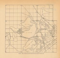
- Subject:
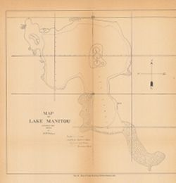
- Topical Subject: IGS Annual Reports, Topical Subject: Lakes, Geographic Subject: Lake Manitou (Ind.), and Geographic Subject: Rochester (Ind.)
- Creator:
- Holman, H. B.
- Publisher:
- Indiana. Department of Geology and Natural Resources
- Date Created:
- 1901
- Identifier:
- VAC3073-M-01066
- Genre:
- Bathymetric maps
- Related URL:
- Catalog URL: https://iucat.iu.edu/catalog/4022271
- Abstract:
- Fulton County, Indiana
- Call Number:
- QE109 .A2 1900 map p220
- Caption:
- Imprint: Indianapolis : 1901
- Physical Description:
- Dimensions: 27 x 27 cm
- Alternate Identifier:
- Title Control Number: 390726IP
- Persistent URL:
- https://purl.dlib.indiana.edu/iudl/images/VAC3073/VAC3073-M-01066
- Provenance:
- 25th Annual Report (1900) / Indiana. Department of Geology and Natural Resources.
-
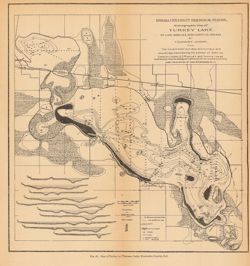
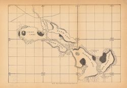
- Subject:
- Topical Subject: Lakes, Topical Subject: Hydrography, Geographic Subject: Kosciusko County (Ind.), Geographic Subject: Wawasee Lake (Ind.), and Topical Subje...
- Creator:
- Indiana University. Biological Station and Juday, Chancey, 1871-1944
- Publisher:
- Indiana. Department of Geology and Natural Resources
- Date Created:
- 1901
- Identifier:
- VAC3073-M-00996
- Genre:
- Bathymetric maps
- Geographic Location:
- Coordinates: W0854500 W0853945 N0412623 N0412211
- Related URL:
- Catalog URL: https://iucat.iu.edu/catalog/18188480
- Abstract:
- Depths shown by soundings and isolines. Map also includes locations of marshes, cat tail swamps, springs, and roads, as well as insets A-J showing cross sect...
- Call Number:
- G4092.W39 1900 .I53
- Caption:
- Imprint: [Indianapolis] : [Wm. B. Burford], [1901]
- Physical Description:
- Scale: 1:27,000. Vertical scale for cross sections 1:3,270 and Dimensions: 25 x 24 cm, on sheet 27 x 27 cm
- Alternate Identifier:
- Alternate ID: 390726IP and Title Control Number: a18188480
- Persistent URL:
- https://purl.dlib.indiana.edu/iudl/images/VAC3073/VAC3073-M-00996
- Provenance:
- 25th Annual Report (1900) / Indiana. Department of Geology and Natural Resources.
-
- Subject:
- Geographic Subject: Fishtrap Lake (Ind.), Geographic Subject: Pine Lake (LaPorte County, Ind. : Lake), Geographic Subject: Twin Lakes (LaPorte County, Ind. :...
- Creator:
- Holman, H. B.
- Publisher:
- Indiana. Department of Geology and Natural Resources
- Date Created:
- 1901
- Identifier:
- VAC3073-M-00937
- Genre:
- Thematic maps
- Geographic Location:
- Coordinates: W0864636 W0864251 N0413859 N0413628
- Related URL:
- Catalog URL: https://iucat.iu.edu/catalog/18418273
- Abstract:
- Surveyed and drawn by H. B. Holman. Shows Pine Lake, Fish Trap Lake, Clear Lake, Stone Lake, Horseshoe Lake, Twin Lakes, and future locations of Lily and Low...
- Call Number:
- G4093.L15C3 1900 .H6
- Caption:
- Imprint: [Indianapolis, Ind.] : [Wm. B. Burford], [1901] and Imprint: [Indianapolis, Ind.] : [Indiana, Department of Geology and Natural Resources], [1901]
- Physical Description:
- Scale: Approximately 1:32,000 and Dimensions: 20 x 21 cm
- Alternate Identifier:
- Title Control Number: a18418273 and Alternate ID: 390726IP
- Persistent URL:
- https://purl.dlib.indiana.edu/iudl/images/VAC3073/VAC3073-M-00937
- Provenance:
- 25th Annual Report (1900) / Indiana. Department of Geology and Natural Resources.
-
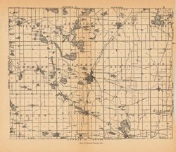
- Subject:
- Topical Subject: IGS Annual Reports, Geographic Subject: Steuben County (Ind.), and Topical Subject: Lakes
- Publisher:
- Indiana. Department of Geology and Natural Resources
- Date Created:
- 1901
- Identifier:
- VAC3073-M-00903
- Genre:
- Thematic maps
- Geographic Location:
- Coordinates: W0851150 W0844817 N0414536 N0413139
- Related URL:
- Catalog URL: https://iucat.iu.edu/catalog/18276218
- Abstract:
- Detached from: The lakes of northern Indiana and their associated marl deposits / W. S. Blatchley and Geo. H. Ashley. In Indiana Department of Geology and N...
- Call Number:
- G4093.S7 1899 .R35
- Caption:
- Imprint: (c)1899, Imprint: [Indianapolis] : [Indiana. Department of Geology and Natural Resources], [1901], and Imprint: [Indianapolis] : [Wm. B. Burford], [...
- Physical Description:
- Dimensions: on sheet 22 x 26 cm and Scale: Approximately 1:135,000
- Alternate Identifier:
- Title Control Number: a18276218 and Alternate ID: 390726IP
- Persistent URL:
- https://purl.dlib.indiana.edu/iudl/images/VAC3073/VAC3073-M-00903
- Provenance:
- 25th Annual Report (1900) / Indiana. Department of Geology and Natural Resources.
-
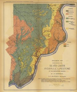
- Subject:
- Geographic Subject: Scott County (Ind.), Topical Subject: Limestone, Topical Subject: IGS Annual Reports, Topical Subject: Geology, Geographic Subject: Clark...
- Creator:
- Siebenthal, C. E. (Claude Ellsworth), 1869-1930
- Publisher:
- Indiana. Department of Geology and Natural Resources
- Date Created:
- 1901
- Identifier:
- VAC3073-M-00893
- Genre:
- Geological maps
- Geographic Location:
- Coordinates: W0855100 W0852100 N0384500 N0381530
- Related URL:
- Catalog URL: https://iucat.iu.edu/catalog/18188442
- Abstract:
- "NOTE - The eastern outcrop of the Knobstone is from map by Ind. Univ. Geol. Surv. Eastern outcrop of Devonian surveyed by J. A. Price. Eastern outcrop ...
- Call Number:
- G4091.H5 1900 .S54
- Caption:
- Imprint: Indianapolis, Ind. : Wm. B. Burford, Lith., [1901]
- Physical Description:
- Scale: Approximately 1:126,720. 2 miles = 1 inch and Dimensions: 47 x 38 cm
- Alternate Identifier:
- Title Control Number: a18188442 and Alternate ID: 390726IP
- Persistent URL:
- https://purl.dlib.indiana.edu/iudl/images/VAC3073/VAC3073-M-00893
- Provenance:
- 25th Annual Report (1900) / Indiana. Department of Geology and Natural Resources.
-
- Subject:
- Geographic Subject: Bass Lake (Starke County, Ind. : Lake), Topical Subject: IGS Annual Reports, Geographic Subject: Starke County (Ind.), and Topical Subjec...
- Publisher:
- Indiana. Department of Geology and Natural Resources
- Date Created:
- 1901
- Identifier:
- VAC3073-M-00348
- Genre:
- Maps
- Geographic Location:
- Coordinates: W0863646 W0863409 N0411431 N0411221
- Related URL:
- Catalog URL: https://iucat.iu.edu/catalog/18189994
- Abstract:
- Depth shown by soundings. Title from caption. Detached from: The lakes of northern Indiana and their associated marl deposits / W. S. Blatchley and Geo. ...
- Call Number:
- G4092.B35 1900 .M37
- Caption:
- Imprint: [Indianapolis] : [Indiana, Department of Geology and Natural Resources], [1901] and Imprint: [Indianapolis] : [Wm. B. Burford], [1901]
- Physical Description:
- Dimensions: 22 x 21 cm and Scale: Approximately 1:21,500
- Alternate Identifier:
- Alternate ID: 390726IP and Title Control Number: a18189994
- Persistent URL:
- https://purl.dlib.indiana.edu/iudl/images/VAC3073/VAC3073-M-00348
- Provenance:
- 25th Annual Report (1900) / Indiana. Department of Geology and Natural Resources.
-
- Subject:
- Geographic Subject: Irish Lake (Ind.), Geographic Subject: Kosciusko County (Ind.), Geographic Subject: Big Barbee Lake (Ind.), Topical Subject: IGS Annual R...
- Publisher:
- Indiana. Department of Geology and Natural Resources
- Date Created:
- 1901
- Identifier:
- VAC3073-M-00295
- Genre:
- Maps
- Geographic Location:
- Coordinates: W0854443 W0854115 N0411820 N0411636
- Related URL:
- Catalog URL: https://iucat.iu.edu/catalog/18189963
- Abstract:
- Shows Barbee chain of lakes and local clubs and parks. Names of lakes as shown on map: Irish, Mabie (Sawmill), Plew (Sechrist), Kuhn (Little Barbee), Hammon ...
- Call Number:
- G4092.B3 1900 .M3
- Caption:
- Imprint: [Indianapolis] : [Dept. of Geology and Natural Resources], [1901]
- Physical Description:
- Dimensions: 22 x 32 cm
- Alternate Identifier:
- Title Control Number: a18189963 and Alternate ID: 390726IP
- Persistent URL:
- https://purl.dlib.indiana.edu/iudl/images/VAC3073/VAC3073-M-00295
- Provenance:
- 25th Annual Report (1900) / Indiana. Department of Geology and Natural Resources.
