
Search Constraints
Search Results
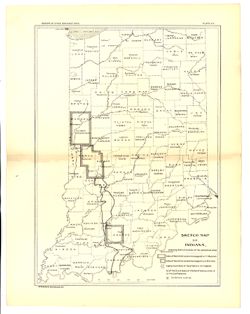
-
- Subject:
- Geographic Subject: Perry County (Ind.), Geographic Subject: Spencer County (Ind.), Topical Subject: Coal, and Geographic Subject: Warrick County (Ind.)
- Creator:
- Ashley, Geo. H. (George Hall), 1866-1951, Kindle, E. M. (Edward Martin), 1869-1940, and Price, J. A.
- Publisher:
- Indiana. Department of Geology and Natural Resources
- Date Created:
- 1898
- Identifier:
- VAC3073-M-01185
- Genre:
- Geological maps
- Geographic Location:
- Coordinates: W0872823 W0862942 N0381446 N0374639
- Related URL:
- Catalog URL: https://iucat.iu.edu/catalog/9160352
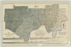
- Abstract:
- By George H. Ashley, assistant geologist, Department of Geology and Natural Resources of Indiana, W.S. Blatchley, state geologist , geology by G.H. Ashley, J...
- Call Number:
- G4093.W4H9 1898 .A8
- Caption:
- Imprint: Indianapolis : Burford, [1899] and Imprint: [Indianapolis, Ind.] : Dept. of Geology and Natural Resources of Indiana, [1899]
- Physical Description:
- Dimensions: 46 x 76 cm and Scale: 1:31,680
- Persistent URL:
- https://purl.dlib.indiana.edu/iudl/images/VAC3073/VAC3073-M-01185
- Provenance:
- 23rd Annual Report (1898) / Indiana. Department of Geology and Natural Resources.
-
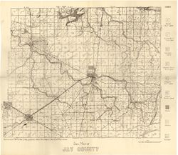
- Subject:
- Topical Subject: Soils and Geographic Subject: Jay County (Ind.)
- Creator:
- Hole, Allen David, 1866-1940
- Publisher:
- Indiana. Department of Geology and Natural Resources
- Date Created:
- 1915
- Identifier:
- VAC3073-M-01184
- Genre:
- Thematic maps
- Geographic Location:
- Coordinates: W0851312 W0844808 N0403419 N0401824
- Related URL:
- Catalog URL: https://iucat.iu.edu/catalog/16152007
- Abstract:
- Detached from: Soil survey of Jay County / Allen David Hole. In 39th Annual report of Department of Geology and Natural Resources, Indiana. From page 54 o...
- Call Number:
- G4093.J4J3 1914 .H6
- Caption:
- Imprint: [Indianapolis] : [Department of Geology and Natural Resources, Indiana], [1915]
- Physical Description:
- Dimensions: 35 x 42 cm and Scale: 1:84,000
- Persistent URL:
- https://purl.dlib.indiana.edu/iudl/images/VAC3073/VAC3073-M-01184
- Provenance:
- 39th Annual Report (1914) / Indiana. Department of Geology and Natural Resources.
-
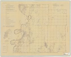
- Subject:
- Topical Subject: Geology, Geographic Subject: Posey County (Ind.), and Topical Subject: Geology, Stratigraphic
- Creator:
- Tanner, George F. (George Frederick), 1953-
- Publisher:
- Indiana. Geological Survey
- Date Created:
- 1981
- Identifier:
- VAC3073-M-01182
- Genre:
- Geological maps and Thematic maps
- Geographic Location:
- Coordinates: W0880552 W0874117 N0381349 N0374618
- Related URL:
- Catalog URL: https://iucat.iu.edu/catalog/5337575
- Call Number:
- G4093.P6C57 1981 .T31
- Caption:
- Imprint: [Bloomington] : Indiana Geological Survey, 1981
- Physical Description:
- Dimensions: 82 x 114 cm and Scale: 1:32,000
- Persistent URL:
- https://purl.dlib.indiana.edu/iudl/images/VAC3073/VAC3073-M-01182
-
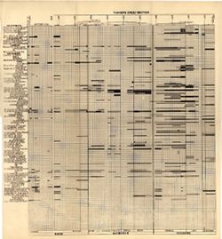
- Subject:
- Topical Subject: Stratigraphic correlation, Topical Subject: Geology, Stratigraphic--Ordovician, Topical Subject: Bilateria, Fossil, Topical Subject: IGS Ann...
- Creator:
- Cumings, E. R. (Edgar Roscoe), 1874-1967 and Galloway, J. J. (Jesse James), 1882-1962
- Publisher:
- Indiana. Department of Geology and Natural Resources
- Date Created:
- 1913
- Identifier:
- VAC3073-M-01183
- Genre:
- Cartographic materials and Graphs
- Geographic Location:
- Coordinates: W0880500 W0844700 N0414500 N0374600
- Related URL:
- Catalog URL: https://iucat.iu.edu/catalog/18416521
- Abstract:
- Sections on one sheet. Title from caption. Diagram showing stratagraphic measurements for bilateria fossils in the Tanner's Creek Formation from the Cinc...
- Call Number:
- G4091.C57 1912 .C8
- Caption:
- Imprint: [Indianapolis] : [Department of Geology and Natural Resources], [1913] and Imprint: [Indianapolis] : [Wm. B. Burford, contractor for state printing ...
- Physical Description:
- Scale: Scale not given. Vertical scale approximately 1:550 and Dimensions: 38 x 41 cm
- Alternate Identifier:
- Title Control Number: a18416521 and Alternate ID: 390726IP
- Persistent URL:
- https://purl.dlib.indiana.edu/iudl/images/VAC3073/VAC3073-M-01183
- Provenance:
- 37th Annual Report (1912) / Indiana. Department of Geology and Natural Resources.
-
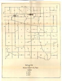
- Subject:
- Geographic Subject: Daviess County (Ind.), Topical Subject: Gas wells, Topical Subject: Oil wells, and Topical Subject: IGS Annual Reports
- Publisher:
- Indiana. Department of Geology and Natural Resources
- Date Created:
- 1917
- Identifier:
- VAC3073-M-01180
- Genre:
- Outline maps
- Geographic Location:
- Coordinates: W0870606 W0865524 N0384112 N0383354
- Related URL:
- Catalog URL: https://iucat.iu.edu/catalog/18418419
- Abstract:
- Shows oil and gas wells. Sheet 5 of 14. Detached from: Oil and gas / Floyd E. Wright. In Forty-first annual report of Department of Geology and Natural Re...
- Call Number:
- G4093.D2H8 1917 .O9
- Caption:
- Imprint: [Fort Wayne, Ind.] : [Fort Wayne Printing Co.], [1917] and Imprint: [Fort Wayne, Ind.] : [Indiana Department of Geology and Natural Resources], [1917]
- Physical Description:
- Dimensions: 43 x 34 cm and Scale: Approximately 1:43,000
- Alternate Identifier:
- Title Control Number: a18418419 and Alternate ID: 390726IP
- Persistent URL:
- https://purl.dlib.indiana.edu/iudl/images/VAC3073/VAC3073-M-01180
- Provenance:
- 41st Annual Report (1916) / Indiana. Department of Geology and Natural Resources.
-
![[Coal measure sections in Indiana, Southern Illinois, and Western Kentucky]](https://iiif.uits.iu.edu/iiif/2/bz60f023f%2Ffiles%2F64b4d7e0-2da2-4574-93ae-d19cd0523815/full/250,/0/default.jpg)
- Subject:
- Geographic Subject: Indiana, Topical Subject: Geology, Stratigraphic, Geographic Subject: Illinois, Geographic Subject: Kentucky, Topical Subject: Coal, and ...
- Creator:
- Lesquereux, Leo, 1806-1889 and Cox, E. T. (Edward Travers), 1821-1907
- Publisher:
- Indiana. Geological Survey
- Date Created:
- 1871
- Identifier:
- VAC3073-M-01181
- Genre:
- Tables (Data) and Charts
- Related URL:
- Catalog URL: https://iucat.iu.edu/catalog/18308391
- Abstract:
- By Prof. E. T. Cox, Prof Leo Lesquereux. Title derived from caption titles. Includes 3 sections showing coal measures. No. 3. Connected section of coal measu...
- Call Number:
- G4091.H9 1870 .C69
- Caption:
- Imprint: [Indianapolis] : [Geological Survey of Indiana], [1871]
- Physical Description:
- Dimensions: 21 x 23 cm and Scale: Scale not given.
- Alternate Identifier:
- Title Control Number: a18308391 and Alternate ID: 390721IP
- Persistent URL:
- https://purl.dlib.indiana.edu/iudl/images/VAC3073/VAC3073-M-01181
- Provenance:
- 2nd Annual Report (1870) / Indiana. Geological Survey.
-
- Subject:
- Topical Subject: Quarries and quarrying, Topical Subject: IGS Annual Reports, Geographic Subject: Indiana, Topical Subject: Sandstone, and Topical Subject: M...
- Creator:
- Hopkins, Thomas Cramer, 1861-1935 and Kindle, E. M. (Edward Martin), 1869-1940
- Publisher:
- Indiana. Department of Geology and Natural Resources
- Date Created:
- 1896
- Identifier:
- VAC3073-M-01179
- Genre:
- Index maps and Thematic maps
- Geographic Location:
- Coordinates: W0880500 W0844700 N0414500 N0374600
- Related URL:
- Catalog URL: https://iucat.iu.edu/catalog/18416374
- Abstract:
- Shows Mansfield sandstone areas and quarries. Plate VIII. Detached from: Area of Mansfield sandstone / mapped by T.C. Hopkins [and] E.M. Kindle. In Indian...
- Call Number:
- G4091.H5 1895 .H6
- Caption:
- Imprint: [Indianapolis] : [Indiana Department of Geology and Natural Resources], [1896] and Imprint: Indianapolis : Wm. B. Burford, [1896]
- Physical Description:
- Scale: Approximately 1:1,788,600 and Dimensions: 30 x 23 cm
- Alternate Identifier:
- Alternate ID: 390726IP and Title Control Number: a18416374
- Persistent URL:
- https://purl.dlib.indiana.edu/iudl/images/VAC3073/VAC3073-M-01179
- Provenance:
- 20th Annual Report (1895) / Indiana. Department of Geology and Natural Resources.
-
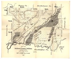
- Subject:
- Geographic Subject: Jackson County (Ind.), Topical Subject: Geology, and Topical Subject: IGS Annual Reports
- Creator:
- Cox, E. T. (Edward Travers), 1821-1907
- Publisher:
- Indiana. Geological Survey
- Date Created:
- 1875
- Identifier:
- VAC3073-M-01177
- Genre:
- Geological maps
- Geographic Location:
- Coordinates: W0861905 W0854741 N0390414 N0384329
- Related URL:
- Catalog URL: https://iucat.iu.edu/catalog/18318685
- Abstract:
- Prepared for the sixth annual report of E[.]T. Cox, State Geologist, 1874. Relief shown by hachures. Shows cities and towns, railroads, geology of the region...
- Call Number:
- G4093.J2C5 1874 .C6
- Caption:
- Imprint: [Indianapolis] : [Geological Survey of Indiana], [1875] and Imprint: [Indianapolis] : [Sentinel Co., printers], [1875]
- Physical Description:
- Scale: Approximately 1:130,000 and Dimensions: on sheet 40 x 47 cm
- Alternate Identifier:
- Title Control Number: a18318685 and Alternate ID: 390723IP
- Persistent URL:
- https://purl.dlib.indiana.edu/iudl/images/VAC3073/VAC3073-M-01177
- Provenance:
- 6th Annual Report (1874) / Indiana. Geological Survey.
-
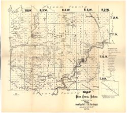
- Subject:
- Geographic Subject: Owen County (Ind.), Topical Subject: IGS Annual Reports, Topical Subject: Geology, Topical Subject: Mines and mineral resources, and Topi...
- Creator:
- Collett, John, 1828-1899
- Publisher:
- Indiana. Geological Survey
- Date Created:
- 1876
- Identifier:
- VAC3073-M-01176
- Genre:
- Geological maps
- Geographic Location:
- Coordinates: W0870316 W0863751 N0392824 N0390957
- Related URL:
- Catalog URL: https://iucat.iu.edu/catalog/18349290
- Abstract:
- Compiled for the 7th annual report of E.T. Cox, State Geologist , geology by Prof. John Collett, 1875. Relief shown by hachures. Shows cities and towns, rail...
- Call Number:
- G4093.O8C5 1875 .C6
- Caption:
- Imprint: [Indianapolis] : [Geological Survey of Indiana], [1876] and Imprint: [Indianapolis] : [Sentinel Co., printers], [1876]
- Physical Description:
- Scale: Approximately 1:130,000 and Dimensions: on sheet 40 x 45 cm
- Alternate Identifier:
- Title Control Number: a18349290 and Alternate ID: 390723IP
- Persistent URL:
- https://purl.dlib.indiana.edu/iudl/images/VAC3073/VAC3073-M-01176
- Provenance:
- 7th Annual Report (1875) / Indiana. Geological Survey.
-
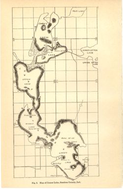
- Subject:
- Geographic Subject: James, Lake (Steuben County, Ind. : Lake), Topical Subject: Lakes, Topical Subject: IGS Annual Reports, Geographic Subject: Steuben Count...
- Publisher:
- Indiana. Department of Geology and Natural Resources
- Date Created:
- 1901
- Identifier:
- VAC3073-M-01178
- Genre:
- Thematic maps
- Geographic Location:
- Coordinates: W0850253 W0850033 N0414428 N0414050
- Related URL:
- Catalog URL: https://iucat.iu.edu/catalog/18190007
- Abstract:
- Depth shown by average depth range for each lake. Also shows information for Snow Lake and general locations of Mud Lake and Upper and Lower Otter Lakes. ...
- Call Number:
- G4092.J27 1900 .M37
- Caption:
- Imprint: [Indianapolis] : [Wm. B. Burford], [1901] and Imprint: [Indianapolis] : [Indiana, Department of Geology and Natural History], [1901]
- Physical Description:
- Dimensions: on sheet 23 x 15 cm and Scale: Approximately 1:32,000
- Alternate Identifier:
- Alternate ID: 390726IP and Title Control Number: a18190007
- Persistent URL:
- https://purl.dlib.indiana.edu/iudl/images/VAC3073/VAC3073-M-01178
- Provenance:
- 25th Annual Report (1900) / Indiana. Department of Geology and Natural Resources.
