
Search Constraints
Search Results
-
- Subject:
- Topical Subject: Soils and Geographic Subject: Dubois County (Ind.)
- Creator:
- Indiana. Department of Geology and Natural Resources
- Publisher:
- Indiana. Department of Geology and Natural Resources
- Date Created:
- 1909
- Identifier:
- VAC3073-M-00808
- Genre:
- Thematic maps
- Geographic Location:
- Coordinates: W0870420 W0864048 N0383133 N0381222
- Related URL:
- Catalog URL: https://iucat.iu.edu/catalog/16091036
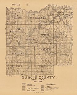
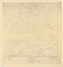
- Abstract:
- Shows school houses, public roads, and railroads. Detached from: A soil survey of four counties of southern Indiana / Chas. W. Shannon and L.C. Snider. In...
- Call Number:
- G4093.D8J3 1908 .I53
- Caption:
- Imprint: [Indianapolis] : [Indiana Department of Geology and Natural Resources], [1909]
- Physical Description:
- Scale: Approximately 1:126,720 and Dimensions: 39 x 33 cm
- Alternate Identifier:
- Title Control Number: a16091036 and Alternate ID: 390726IP
- Persistent URL:
- https://purl.dlib.indiana.edu/iudl/images/VAC3073/VAC3073-M-00808
- Provenance:
- 33rd Annual Report (1908) / Indiana. Department of Geology and Natural Resources.
-
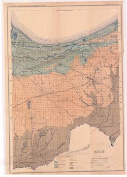
- Subject:
- Geographic Subject: Lake County (Ind.), Topical Subject: IGS Annual Reports, Geographic Subject: Porter County (Ind.), Topical Subject: Geology, and Topical ...
- Creator:
- Ashley, Geo. H. (George Hall), 1866-1951
- Publisher:
- Indiana. Department of Geology and Natural Resources
- Date Created:
- 1898
- Identifier:
- VAC3073-M-00806
- Genre:
- Geological maps
- Geographic Location:
- Coordinates: W0873136 W0865435 N0414259 N0410943
- Related URL:
- Catalog URL: https://iucat.iu.edu/catalog/17035654
- Abstract:
- Shows lakes, beaches, sand-dune area, morainic area, till plains, crest of moraine, and Kankakee Marsh area. Detached from: The geology of Lake and Porter...
- Call Number:
- G4093.L3C5 1897 .A8
- Caption:
- Imprint: [Indianapolis] : Department of Geology and Natural Resources of Indiana, [1898] and Imprint: Indianapolis, Ind. : Wm. B. Burford, lith., [1898]
- Physical Description:
- Dimensions: 55 x 42 cm and Scale: Approximately 1:126,720. 2 miles = 1 inch
- Alternate Identifier:
- Title Control Number: a17035654 and Alternate ID: 390726IP
- Persistent URL:
- https://purl.dlib.indiana.edu/iudl/images/VAC3073/VAC3073-M-00806
- Provenance:
- 22nd Annual Report (1897) / Indiana. Department of Geology and Natural Resources.
-
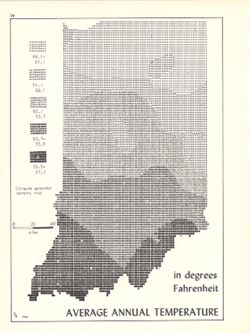
- Subject:
- Topical Subject: SYMAP (Computer program language), Geographic Subject: Indiana, and Topical Subject: Atmospheric temperature
- Creator:
- Indiana University. Research Computing Center and Kingsbury, Robert C.
- Publisher:
- Indiana University. Department of Geography
- Date Created:
- 1970
- Identifier:
- VAC3073-M-00805
- Genre:
- Thematic maps
- Geographic Location:
- Coordinates: W0880700 W0844500 N0414500 N0374600
- Related URL:
- Catalog URL: https://iucat.iu.edu/catalog/15995471
- Abstract:
- Computer generated isometric map obtained through use of the facilities of Indiana University's Research Computer Center. ASCII-art map created using SYM...
- Call Number:
- G4091.C82 1970 .K56
- Caption:
- Imprint: Bloomington, Indiana : Department of Geography, Indiana University, [1970]
- Physical Description:
- Dimensions: 26 x 18 cm and Scale: Approximately 1:1,950,000
- Alternate Identifier:
- Alternate ID: 317383IP and Title Control Number: a15995471
- Persistent URL:
- https://purl.dlib.indiana.edu/iudl/images/VAC3073/VAC3073-M-00805
- Provenance:
- An atlas of Indiana / by Robert C. Kingsbury [1970].
-
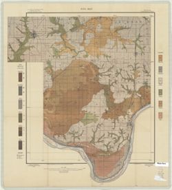
- Subject:
- Topical Subject: Soils, Geographic Subject: Spencer County (Ind.), Geographic Subject: Warrick County (Ind.), Geographic Subject: Boonville (Ind.), and Topic...
- Creator:
- Mangum, A. W.
- Publisher:
- United States. Bureau of Soils
- Date Created:
- 1904
- Identifier:
- VAC3073-M-00804
- Genre:
- Thematic maps
- Geographic Location:
- Coordinates: W0871000 W0870000 N0380500 N0374600
- Related URL:
- Catalog URL: https://iucat.iu.edu/catalog/2874208
- Abstract:
- Relief shown by contours. Map covers portions of Spencer and Warrick Counties in Indiana. Shows soil types classification by colors and symbols. "Field ...
- Call Number:
- G4093 .S5J3 1904 .M36
- Caption:
- Imprint: [Washington, D.C.?] : The Bureau, [1904?]
- Physical Description:
- Scale: 1:63,360
- Alternate Identifier:
- Title Control Number: CAZ0472BB
- Persistent URL:
- https://purl.dlib.indiana.edu/iudl/images/VAC3073/VAC3073-M-00804
-
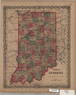
- Subject:
- Geographic Subject: Indiana
- Creator:
- Colton, J. H. (Joseph Hutchins), 1800-1893
- Publisher:
- J.H. Colton & Co.
- Date Created:
- 1860
- Identifier:
- VAC3073-M-00803
- Genre:
- Maps
- Geographic Location:
- Coordinates: W0880700 W0844500 N0414500 N0375200
- Related URL:
- Catalog URL: https://iucat.iu.edu/catalog/5175636
- Abstract:
- Prime meridian: Washington. Detached from an atlas, no. 41. Verso: The state of Michigan [text]
- Call Number:
- G4090 1860 .C65
- Caption:
- Imprint: New York : J.H. Colton, [186-?]
- Physical Description:
- Scale: 1:1,300,000 and Dimensions: 36 x 29 cm
- Alternate Identifier:
- Title Control Number: a5175636
- Persistent URL:
- https://purl.dlib.indiana.edu/iudl/images/VAC3073/VAC3073-M-00803
-
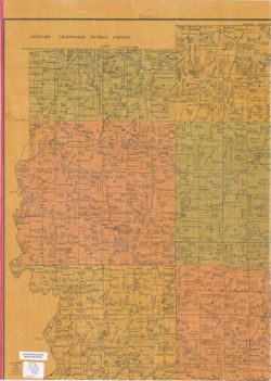
- Subject:
- Topical Subject: Landowners, Geographic Subject: Perry County (Ind.), and Topical Subject: Real property
- Creator:
- Minto, George
- Publisher:
- Minto, George
- Date Created:
- 1894
- Identifier:
- VAC3073-M-00801
- Genre:
- Cadastral maps
- Geographic Location:
- Coordinates: W0864900 W0862600 N0382600 N0375000
- Related URL:
- Catalog URL: https://iucat.iu.edu/catalog/4681682
- Abstract:
- Cadastral map showing landowners. Includes statistical chart for Perry County.
- Call Number:
- G4093 .P3G46 1894 .M56
- Caption:
- Imprint: Cannelton, Ind. : George Minto, 1894.
- Physical Description:
- Dimensions: 115 x 84 cm, pieces 61 x 44 cm and Scale: 1:42,240
- Alternate Identifier:
- Title Control Number: CAT6625BB
- Persistent URL:
- https://purl.dlib.indiana.edu/iudl/images/VAC3073/VAC3073-M-00801
-
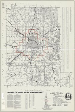
- Subject:
- Geographic Subject: Monroe County (Ind.) and Topical Subject: Roads
- Creator:
- Klooz, C. J.
- Publisher:
- Columbus Reproduction & Supply Co.
- Date Created:
- 1987
- Identifier:
- VAC3073-M-00800
- Genre:
- Road maps
- Geographic Location:
- Coordinates: W0864100 W0861900 N0392100 N0390000
- Related URL:
- Catalog URL: https://iucat.iu.edu/catalog/5297915
- Abstract:
- Includes text and indexes and logo of the Monroe County Department of Highways. Shows "2 mile fringe" and "Ellettsville Corp. Bdry." in...
- Call Number:
- G4093.M7P2 1987 .K6
- Caption:
- Imprint: Columbus, Ind. : The Company, 1987.
- Physical Description:
- Scale: 1:63,360 and Dimensions: 68 x 55 cm
- Alternate Identifier:
- Title Control Number: a5297915
- Persistent URL:
- https://purl.dlib.indiana.edu/iudl/images/VAC3073/VAC3073-M-00800
-
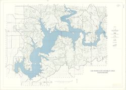
- Subject:
- Topical Subject: Phytogeography, Geographic Subject: Indiana, and Geographic Subject: Monroe, Lake, Watershed (Ind.)
- Publisher:
- [publisher not identified]
- Date Created:
- 1975
- Identifier:
- VAC3073-M-00799
- Genre:
- Thematic maps
- Geographic Location:
- Coordinates: W0863138 W0861831 N0390711 N0385936
- Related URL:
- Catalog URL: https://iucat.iu.edu/catalog/5302581
- Abstract:
- Appears to be a reprint of a map from the 1975 Lake Monroe Land Suitability Study.
- Call Number:
- G4092.M6 D2 1975 .L3
- Caption:
- Imprint: [Place of publication not identified] : [publisher not identified], [197?]
- Physical Description:
- Scale: 1:24,000 and Dimensions: 67 x 94 cm
- Alternate Identifier:
- Title Control Number: a5302581
- Persistent URL:
- https://purl.dlib.indiana.edu/iudl/images/VAC3073/VAC3073-M-00799
-
- Subject:
- Topical Subject: Karst, Topical Subject: Caves, and Geographic Subject: Van Buren (Monroe County, Ind. : Township)
- Creator:
- Powell, Richard L.
- Publisher:
- [publisher not identified]
- Date Created:
- 1968
- Identifier:
- VAC3073-M-00797
- Genre:
- Thematic maps
- Geographic Location:
- Coordinates: W0864058 W0863422 N0390956 N0390443
- Related URL:
- Catalog URL: https://iucat.iu.edu/catalog/5327209
- Abstract:
- Blue line print. _x000d_ "Base prepared from Bloomington, Clear Creek, Stanford and Whitehall topographic quadrangles, U.S.G.S, by the Indiana Geolog...
- Call Number:
- G4094.V28 C23 1968 .P69
- Caption:
- Imprint: [Place of publication not identified] : [publisher not identified], [1968?]
- Physical Description:
- Scale: 1:6,000 and Dimensions: 91 x 92 cm
- Alternate Identifier:
- Title Control Number: a5327209
- Persistent URL:
- https://purl.dlib.indiana.edu/iudl/images/VAC3073/VAC3073-M-00797
-
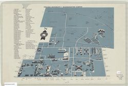
- Subject:
- Geographic Subject: Bloomington (Ind.), Geographic Subject: Indiana University, Bloomington, and Topical Subject: Indiana University, Bloomington
- Publisher:
- [Indiana University?]
- Date Created:
- 1958
- Identifier:
- VAC3073-M-00798
- Genre:
- Maps
- Geographic Location:
- Coordinates: W0863138 W0863031 N0391111 N0390950
- Related URL:
- Catalog URL: https://iucat.iu.edu/catalog/5289435
- Abstract:
- Perspective map.
- Call Number:
- G4094.B5:2I6 1958 .I6
- Caption:
- Imprint: [Bloomington?] : [Indiana University?, [1958?]
- Physical Description:
- Scale: Scale not given. and Dimensions: 36 x 25 cm
- Alternate Identifier:
- Title Control Number: a5289435
- Persistent URL:
- https://purl.dlib.indiana.edu/iudl/images/VAC3073/VAC3073-M-00798
