
Search Constraints
You searched for:
Publisher
Indiana University. Department of Geography
Remove constraint Publisher: Indiana University. Department of Geography
Subject
Topical Subject: SYMAP (Computer program language)
Remove constraint Subject: Topical Subject: SYMAP (Computer program language)
« Previous |
1 - 10 of 18
|
Next »
Search Results
-
- Subject:
- Topical Subject: SYMAP (Computer program language), Topical Subject: Atmospheric temperature, and Geographic Subject: Indiana
- Creator:
- Kingsbury, Robert C.
- Publisher:
- Indiana University. Department of Geography
- Date Created:
- 1970
- Identifier:
- VAC3073-M-01021
- Genre:
- Thematic maps
- Geographic Location:
- Coordinates: W0880700 W0844500 N0414500 N0374600
- Related URL:
- Catalog URL: https://iucat.iu.edu/catalog/15995455
- Abstract:
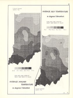
- 2 maps on 1 sheet, Average January temperature in degrees Fahrenheit and Average July temperature in degrees Fahrenheit. Computer generated isometric maps ob...
- Call Number:
- G4091.C82 1970 .K57
- Caption:
- Imprint: Bloomington, Indiana : Department of Geography, Indiana University, [1970]
- Physical Description:
- Dimensions: each 26 x 10 cm, on sheet 28 x 21 cm and Scale: Approximately 1:3,000,000
- Alternate Identifier:
- Title Control Number: a15995455 and Alternate ID: 317383IP
- Persistent URL:
- https://purl.dlib.indiana.edu/iudl/images/VAC3073/VAC3073-M-01021
- Provenance:
- An atlas of Indiana / by Robert C. Kingsbury [1970].
-
- Subject:
- Geographic Subject: Indiana, Topical Subject: Population geography, and Topical Subject: SYMAP (Computer program language)
- Creator:
- Hollingsworth, John M., Indiana University. Research Computing Center, and Kingsbury, Robert C.
- Publisher:
- Indiana University. Department of Geography
- Date Created:
- 1970
- Identifier:
- VAC3073-M-01005
- Genre:
- Thematic maps
- Geographic Location:
- Coordinates: W0880700 W0844500 N0414500 N0374600
- Related URL:
- Catalog URL: https://iucat.iu.edu/catalog/15946819
- Abstract:
- Computer generated isopleth map obtained through use of the facilities of Indiana University's Research Computer Center. ASCII-art map created using SYMA...
- Call Number:
- G4091.E2 1960 .K55
- Caption:
- Imprint: Bloomington, Indiana : Department of Geography, Indiana University, [1970]
- Physical Description:
- Scale: Approximately 1:1,950,000 and Dimensions: 26 x 18 cm, on sheet 28 x 21 cm
- Alternate Identifier:
- Title Control Number: a15946819 and Alternate ID: 317383IP
- Persistent URL:
- https://purl.dlib.indiana.edu/iudl/images/VAC3073/VAC3073-M-01005
- Provenance:
- An atlas of Indiana / by Robert C. Kingsbury [1970].
-
- Subject:
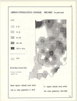
- Topical Subject: Population geography, Topical Subject: Historical geography, Topical Subject: SYMAP (Computer program language), Geographic Subject: Indiana...
- Creator:
- Hollingsworth, John M., Indiana University. Research Computing Center, and Kingsbury, Robert C.
- Publisher:
- Indiana University. Department of Geography
- Date Created:
- 1970
- Identifier:
- VAC3073-M-00926
- Genre:
- Thematic maps
- Geographic Location:
- Coordinates: W0880700 W0844500 N0414500 N0374600
- Related URL:
- Catalog URL: https://iucat.iu.edu/catalog/15948261
- Abstract:
- Computer generated isopleth map obtained through use of the facilities of Indiana University's Research Computer Center. ASCII-art map created using SYMA...
- Call Number:
- G4091.E2 1960 .K52
- Caption:
- Imprint: Bloomington, Indiana : Department of Geography, Indiana University, [1970]
- Physical Description:
- Dimensions: 26 x 18 cm, on sheet 28 x 21 cm and Scale: Approximately 1:2,500,000
- Alternate Identifier:
- Alternate ID: 317383IP and Title Control Number: a15948261
- Persistent URL:
- https://purl.dlib.indiana.edu/iudl/images/VAC3073/VAC3073-M-00926
- Provenance:
- An atlas of Indiana / by Robert C. Kingsbury [1970].
-
- Subject:
- Topical Subject: Farms, Topical Subject: SYMAP (Computer program language), Geographic Subject: Indiana, and Topical Subject: Agricultural resources
- Creator:
- Indiana University. Research Computing Center, Hollingsworth, John M., and Kingsbury, Robert C.
- Publisher:
- Indiana University. Department of Geography
- Date Created:
- 1970
- Identifier:
- VAC3073-M-00865
- Genre:
- Thematic maps
- Geographic Location:
- Coordinates: W0880700 W0844500 N0414500 N0374600
- Related URL:
- Catalog URL: https://iucat.iu.edu/catalog/15995407
- Abstract:
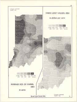
- 2 maps on 1 sheet, Farm land values, 1964, in dollars per acre and Average size of farms, 1964, in acres. Computer generated isopleth maps obtained through u...
- Call Number:
- G4091.J1 1964 .K57
- Caption:
- Imprint: Bloomington, Indiana : Department of Geography, Indiana University, [1970]
- Physical Description:
- Scale: Approximately 1:3,000,000 and Dimensions: each 26 x 10 cm, on sheet 28 x 21 cm
- Alternate Identifier:
- Alternate ID: 317383IP and Title Control Number: a15995407
- Persistent URL:
- https://purl.dlib.indiana.edu/iudl/images/VAC3073/VAC3073-M-00865
- Provenance:
- An atlas of Indiana / by Robert C. Kingsbury [1970].
-
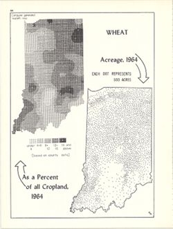
- Subject:
- Topical Subject: SYMAP (Computer program language), Topical Subject: Wheat--Geographical distribution, and Geographic Subject: Indiana
- Creator:
- Indiana University. Research Computing Center, Hollingsworth, John M., and Kingsbury, Robert C.
- Publisher:
- Indiana University. Department of Geography
- Date Created:
- 1970
- Identifier:
- VAC3073-M-00862
- Genre:
- Thematic maps
- Geographic Location:
- Coordinates: W0880700 W0844500 N0414500 N0374600
- Related URL:
- Catalog URL: https://iucat.iu.edu/catalog/15984674
- Abstract:
- Dot distribution map. Includes ancillary computer generated isopleth map Wheat as a percent of all cropland, 1964. ASCII-art map created using SYMAP or simil...
- Call Number:
- G4091.J61 1964 .K57
- Caption:
- Imprint: Bloomington, Indiana : Department of Geography, Indiana University, [1970]
- Physical Description:
- Dimensions: 26 x 18 cm, on sheet 28 x 21 cm and Scale: Approximately 1:2,534,400
- Alternate Identifier:
- Alternate ID: 317383IP and Title Control Number: a15984674
- Persistent URL:
- https://purl.dlib.indiana.edu/iudl/images/VAC3073/VAC3073-M-00862
- Provenance:
- An atlas of Indiana / by Robert C. Kingsbury [1970].
-
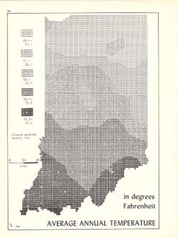
- Subject:
- Topical Subject: SYMAP (Computer program language), Geographic Subject: Indiana, and Topical Subject: Atmospheric temperature
- Creator:
- Indiana University. Research Computing Center and Kingsbury, Robert C.
- Publisher:
- Indiana University. Department of Geography
- Date Created:
- 1970
- Identifier:
- VAC3073-M-00805
- Genre:
- Thematic maps
- Geographic Location:
- Coordinates: W0880700 W0844500 N0414500 N0374600
- Related URL:
- Catalog URL: https://iucat.iu.edu/catalog/15995471
- Abstract:
- Computer generated isometric map obtained through use of the facilities of Indiana University's Research Computer Center. ASCII-art map created using SYM...
- Call Number:
- G4091.C82 1970 .K56
- Caption:
- Imprint: Bloomington, Indiana : Department of Geography, Indiana University, [1970]
- Physical Description:
- Dimensions: 26 x 18 cm and Scale: Approximately 1:1,950,000
- Alternate Identifier:
- Alternate ID: 317383IP and Title Control Number: a15995471
- Persistent URL:
- https://purl.dlib.indiana.edu/iudl/images/VAC3073/VAC3073-M-00805
- Provenance:
- An atlas of Indiana / by Robert C. Kingsbury [1970].
-
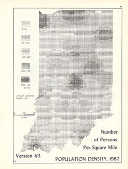
- Subject:
- Geographic Subject: Indiana, Topical Subject: SYMAP (Computer program language), and Topical Subject: Population density
- Creator:
- Indiana University. Research Computing Center, Hollingsworth, John M., and Kingsbury, Robert C.
- Publisher:
- Indiana University. Department of Geography
- Date Created:
- 1970
- Identifier:
- VAC3073-M-00762
- Genre:
- Thematic maps
- Geographic Location:
- Coordinates: W0880700 W0844500 N0414500 N0374600
- Related URL:
- Catalog URL: https://iucat.iu.edu/catalog/15945757
- Abstract:
- Computer generated isopleth map obtained through use of the facilities of Indiana University's Research Computer Center. ASCII-art map created using SYMA...
- Call Number:
- G4091.E2 1960 .K58
- Caption:
- Imprint: Bloomington, Indiana : Department of Geography, Indiana University, [1970]
- Physical Description:
- Dimensions: 26 x 18 cm, on sheet 28 x 21 cm and Scale: Approximately 1:1,950,000
- Alternate Identifier:
- Title Control Number: a15945757 and Alternate ID: 317383IP
- Persistent URL:
- https://purl.dlib.indiana.edu/iudl/images/VAC3073/VAC3073-M-00762
- Provenance:
- An atlas of Indiana / by Robert C. Kingsbury [1970].
-
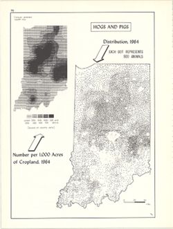
- Subject:
- Geographic Subject: Indiana, Topical Subject: Swine--Geographical distribution, and Topical Subject: SYMAP (Computer program language)
- Creator:
- Hollingsworth, John M., Kingsbury, Robert C., and Indiana University. Research Computing Center
- Publisher:
- Indiana University. Department of Geography
- Date Created:
- 1970
- Identifier:
- VAC3073-M-00632
- Genre:
- Thematic maps
- Geographic Location:
- Coordinates: W0880700 W0844500 N0414500 N0374600
- Related URL:
- Catalog URL: https://iucat.iu.edu/catalog/15984668
- Abstract:
- Dot distribution map. Includes ancillary computer generated isopleth map Hogs and pigs: number per 1,000 acres of cropland, 1964. ASCII-art map created using...
- Call Number:
- G4091.J5 1964 .K57
- Caption:
- Imprint: Bloomington, Indiana : Department of Geography, Indiana University, [1970]
- Physical Description:
- Dimensions: 26 x 18 cm, on sheet 28 x 21 cm and Scale: Approximately 1:2,534,400
- Alternate Identifier:
- Title Control Number: a15984668 and Alternate ID: 317383IP
- Persistent URL:
- https://purl.dlib.indiana.edu/iudl/images/VAC3073/VAC3073-M-00632
- Provenance:
- An atlas of Indiana / by Robert C. Kingsbury [1970].
-
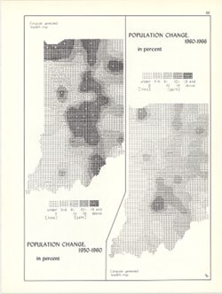
- Subject:
- Geographic Subject: Indiana, Topical Subject: Historical geography, Topical Subject: Population geography, and Topical Subject: SYMAP (Computer program langu...
- Creator:
- Hollingsworth, John M., Kingsbury, Robert C., and Indiana University. Research Computing Center
- Publisher:
- Indiana University. Department of Geography
- Date Created:
- 1970
- Identifier:
- VAC3073-M-00626
- Genre:
- Thematic maps
- Geographic Location:
- Coordinates: W0880700 W0844500 N0414500 N0374600
- Related URL:
- Catalog URL: https://iucat.iu.edu/catalog/15946818
- Abstract:
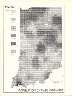
- 2 maps on 1 sheet (Population change, 1950-1960, Population change, 1960-1966). Computer generated isopleth maps obtained through use of the facilities of In...
- Call Number:
- G4091.E2 1960 .K54
- Caption:
- Imprint: Bloomington, Indiana : Department of Geography, Indiana University, [1970]
- Physical Description:
- Dimensions: each 26 x 10 cm, on sheet 28 x 21 cm and Scale: Approximately 1:3,000,000
- Alternate Identifier:
- Alternate ID: 317383IP and Title Control Number: a15946818
- Persistent URL:
- https://purl.dlib.indiana.edu/iudl/images/VAC3073/VAC3073-M-00626
- Provenance:
- An atlas of Indiana / by Robert C. Kingsbury [1970].
-
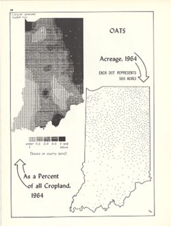
- Subject:
- Topical Subject: SYMAP (Computer program language), Geographic Subject: Indiana, and Topical Subject: Oats--Geographical distribution
- Creator:
- Hollingsworth, John M., Indiana University. Research Computing Center, and Kingsbury, Robert C.
- Publisher:
- Indiana University. Department of Geography
- Date Created:
- 1970
- Identifier:
- VAC3073-M-00391
- Genre:
- Thematic maps
- Geographic Location:
- Coordinates: W0880700 W0844500 N0414500 N0374600
- Related URL:
- Catalog URL: https://iucat.iu.edu/catalog/15984672
- Abstract:
- Dot distribution map. Includes ancillary computer generated isopleth map Oats as a percent of all cropland, 1964. ASCII-art map created using SYMAP or simila...
- Call Number:
- G4091.J61 1964 .K56
- Caption:
- Imprint: Bloomington, Indiana : Department of Geography, Indiana University, [1970]
- Physical Description:
- Dimensions: 26 x 18 cm, on sheet 28 x 21 cm and Scale: Approximately 1:2,534,400
- Alternate Identifier:
- Alternate ID: 317383IP and Title Control Number: a15984672
- Persistent URL:
- https://purl.dlib.indiana.edu/iudl/images/VAC3073/VAC3073-M-00391
- Provenance:
- An atlas of Indiana / by Robert C. Kingsbury [1970].
