
Search Constraints
You searched for:
Campus
IUB
Remove constraint Campus: IUB
County
Inyo
Remove constraint County: Inyo
Type
Image
Remove constraint Type: Image
Pages
0-99 pages
Remove constraint Pages: 0-99 pages
Search Results
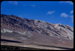
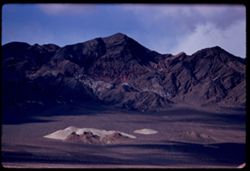
-
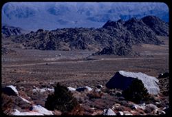
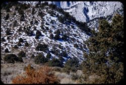
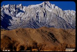
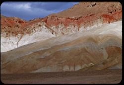
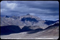
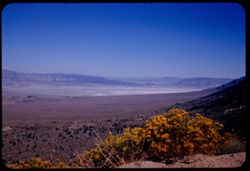
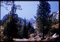
- Description:
- 100 f 6.3 tl
- Subject:
- Rocks, Roads, Trails & paths, Mountains, Shrubs, Alabama Hills (Calif.), and Rock formations
- Series:
- 4-55
- Creator:
- Cushman, Charles W., 1896-1972
- Date Created:
- 1955-02-28
- Genre:
- Landscape photographs
- Frame Number:
- 1
- Street Address:
- Mount Whitney Road
- County:
- Inyo
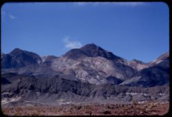
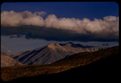
- Abstract:
- Alabama Hills from Mt Whitney road
- Call Number:
- P07630
- Country:
- United States
- State/Province:
- California
- Alternate Identifier:
- 455.1
- Persistent URL:
- http://purl.dlib.indiana.edu/iudl/archives/cushman/P07630
- Holding Location:
- Bloomington - University Archives
Wells Library E460
1320 E 10th St.
Bloomington, IN 47405
Contact at archives@indiana.edu, 812-855-1127
-
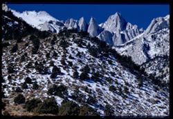
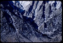
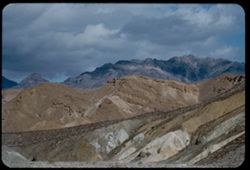
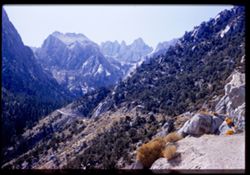
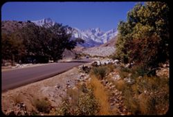
- Description:
- 100 f 8 tl
- Subject:
- Valleys, Whitney, Mount (Calif.), Mountains, Shrubs, Snow, Trees, Rocks, and Rock formations
- Series:
- 3-55
- Creator:
- Cushman, Charles W., 1896-1972
- Date Created:
- 1955-02-28
- Genre:
- Landscape photographs
- Frame Number:
- 37
- Street Address:
- Portal Road
- County:
- Inyo
- Abstract:
- Mt. Whitney
- Call Number:
- P07628
- Country:
- United States
- State/Province:
- California
- Physical Description:
- Image was originally mounted in a glass enclosure. Before digitization, the image was removed and placed in a Wess Plastic, Inc. brand, 2" x 2", pl...
- Alternate Identifier:
- 355.37
- Persistent URL:
- http://purl.dlib.indiana.edu/iudl/archives/cushman/P07628
- Holding Location:
- Bloomington - University Archives
Wells Library E460
1320 E 10th St.
Bloomington, IN 47405
Contact at archives@indiana.edu, 812-855-1127
-
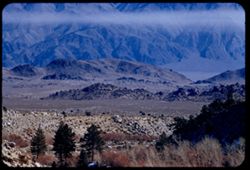
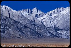
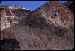
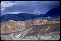
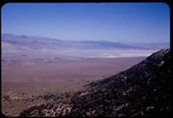
- Description:
- 100 f 6.3 tl
- Subject:
- Owens Valley (Calif.), Mountains, Shrubs, Trees, Rocks, and Valleys
- Series:
- 3-55
- Creator:
- Cushman, Charles W., 1896-1972
- Date Created:
- 1955-02-28
- Genre:
- Landscape photographs
- Frame Number:
- 36
- Street Address:
- Mount Whitney Road
- County:
- Inyo
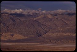
- Abstract:
- East across Owens Valley from Mt. Whitney rd.
- Call Number:
- P07627
- Country:
- United States
- State/Province:
- California
- Alternate Identifier:
- 355.36
- Persistent URL:
- http://purl.dlib.indiana.edu/iudl/archives/cushman/P07627
- Holding Location:
- Bloomington - University Archives
Wells Library E460
1320 E 10th St.
Bloomington, IN 47405
Contact at archives@indiana.edu, 812-855-1127
-
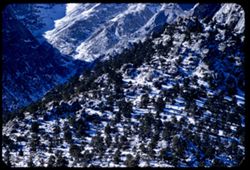
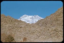
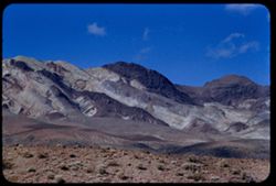
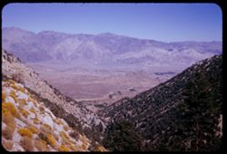
- Description:
- 100 f 5.6 tl
- Subject:
- Snow, Valleys, Trees, Lone Pine Peak (Calif.), Mountains, Shrubs, and Rocks
- Series:
- 3-55
- Creator:
- Cushman, Charles W., 1896-1972
- Date Created:
- 1955-02-28
- Genre:
- Landscape photographs
- Frame Number:
- 35
- Street Address:
- Mount Whitney Road
- County:
- Inyo
- Abstract:
- top of Lone Pine Pk
- Call Number:
- P07626
- City:
- Lone Pine
- Country:
- United States
- State/Province:
- California
- Alternate Identifier:
- 355.35
- Persistent URL:
- http://purl.dlib.indiana.edu/iudl/archives/cushman/P07626
- Holding Location:
- Bloomington - University Archives
Wells Library E460
1320 E 10th St.
Bloomington, IN 47405
Contact at archives@indiana.edu, 812-855-1127
-

- Description:
- 100 f 7+ tl
- Subject:
- Snow, Trees, Mountains, Buildings, Shrubs, and Whitney, Mount (Calif.)
- Series:
- 3-55
- Creator:
- Cushman, Charles W., 1896-1972
- Date Created:
- 1955-02-27
- Genre:
- Landscape photographs
- Frame Number:
- 34
- Street Address:
- Portal Road
- County:
- Inyo
- Abstract:
- view of Whitney Road from 9 mi. up the Whitney Portal rd.
- Call Number:
- P07625
- City:
- Lone Pine
- Country:
- United States
- State/Province:
- California
- Alternate Identifier:
- 355.34
- Persistent URL:
- http://purl.dlib.indiana.edu/iudl/archives/cushman/P07625
- Holding Location:
- Bloomington - University Archives
Wells Library E460
1320 E 10th St.
Bloomington, IN 47405
Contact at archives@indiana.edu, 812-855-1127
-
- Description:
- 100 f 6.3 tl
- Subject:
- Valleys, Mountains, Shrubs, Snow, Trees, and Rocks
- Series:
- 3-55
- Creator:
- Cushman, Charles W., 1896-1972
- Date Created:
- 1955-02-28
- Genre:
- Landscape photographs
- Frame Number:
- 33
- Street Address:
- Mount Whitney Road and Whitney Portal Road
- County:
- Inyo
- Abstract:
- view of Whitney Road from 9 mi. up the Whitney Portal rd.
- Call Number:
- P07624
- City:
- Lone Pine
- Country:
- United States
- State/Province:
- California
- Alternate Identifier:
- 355.33
- Persistent URL:
- http://purl.dlib.indiana.edu/iudl/archives/cushman/P07624
- Holding Location:
- Bloomington - University Archives
Wells Library E460
1320 E 10th St.
Bloomington, IN 47405
Contact at archives@indiana.edu, 812-855-1127
-
- Description:
- 100 f 8 tl
- Subject:
- Snow, Canyons, Trees, Lone Pine Peak (Calif.), Mountains, and Shrubs
- Series:
- 3-55
- Creator:
- Cushman, Charles W., 1896-1972
- Date Created:
- 1955-02-28
- Genre:
- Landscape photographs
- Frame Number:
- 32
- Street Address:
- Mount Whitney Road
- County:
- Inyo
- Abstract:
- Base of Lone Pine Peak
- Call Number:
- P07623
- Country:
- United States
- State/Province:
- California
- Alternate Identifier:
- 355.32
- Persistent URL:
- http://purl.dlib.indiana.edu/iudl/archives/cushman/P07623
- Holding Location:
- Bloomington - University Archives
Wells Library E460
1320 E 10th St.
Bloomington, IN 47405
Contact at archives@indiana.edu, 812-855-1127
-
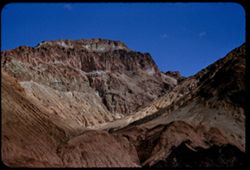
- Description:
- 100 f 8 tl
- Subject:
- Rocks, Canyons, Mountains, Rock formations, Whitney, Mount (Calif.), Snow, and Shrubs
- Series:
- 3-55
- Creator:
- Cushman, Charles W., 1896-1972
- Date Created:
- 1955-02-28
- Genre:
- Landscape photographs
- Frame Number:
- 31
- County:
- Inyo
- Abstract:
- Whitney
- Call Number:
- P07622
- Country:
- United States
- State/Province:
- California
- Alternate Identifier:
- 355.31
- Persistent URL:
- http://purl.dlib.indiana.edu/iudl/archives/cushman/P07622
- Holding Location:
- Bloomington - University Archives
Wells Library E460
1320 E 10th St.
Bloomington, IN 47405
Contact at archives@indiana.edu, 812-855-1127
-
- Description:
- 100 f 8 tl
- Subject:
- Rocks, Mountains, Williamson, Mount (Inyo County, Calif.), Alabama Hills (Calif.), Hills, Snow, and Shrubs
- Series:
- 3-55
- Creator:
- Cushman, Charles W., 1896-1972
- Date Created:
- 1955-02-28
- Genre:
- Landscape photographs
- Frame Number:
- 30
- County:
- Inyo
- Abstract:
- High Mtn north of Whitney (Mt. Williamson) seen through gap in Alabama Hills
- Call Number:
- P07621
- City:
- Lone Pine
- Country:
- United States
- State/Province:
- California
- Alternate Identifier:
- 355.30
- Persistent URL:
- http://purl.dlib.indiana.edu/iudl/archives/cushman/P07621
- Holding Location:
- Bloomington - University Archives
Wells Library E460
1320 E 10th St.
Bloomington, IN 47405
Contact at archives@indiana.edu, 812-855-1127
-
- Description:
- 100 f 7 tl
- Subject:
- Lone Pine Peak (Calif.), Mountains, Dwellings, Snow, Trees, Fences, and Utility poles
- Series:
- 3-55
- Creator:
- Cushman, Charles W., 1896-1972
- Date Created:
- 1955-02-28
- Genre:
- Landscape photographs
- Frame Number:
- 29
- County:
- Inyo
- Abstract:
- Lone Pine Pk
- Call Number:
- P07620
- City:
- Lone Pine
- Country:
- United States
- State/Province:
- California
- Alternate Identifier:
- 355.29
- Persistent URL:
- http://purl.dlib.indiana.edu/iudl/archives/cushman/P07620
- Holding Location:
- Bloomington - University Archives
Wells Library E460
1320 E 10th St.
Bloomington, IN 47405
Contact at archives@indiana.edu, 812-855-1127
-
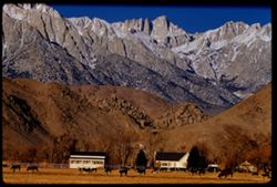
- Description:
- 100 f 8 tl
- Subject:
- Snow, Dairy farming, Farmhouses, Trees, Cattle, Mountains, Fences, Cows, Whitney, Mount (Calif.), and Rocks
- Series:
- 3-55
- Creator:
- Cushman, Charles W., 1896-1972
- Date Created:
- 1955-02-28
- Genre:
- Landscape photographs
- Frame Number:
- 28
- Street Address:
- United States Highway 6
- County:
- Inyo
- Abstract:
- Mt Whitney
- Call Number:
- P07619
- City:
- Lone Pine
- Country:
- United States
- State/Province:
- California
- Alternate Identifier:
- 355.28
- Persistent URL:
- http://purl.dlib.indiana.edu/iudl/archives/cushman/P07619
- Holding Location:
- Bloomington - University Archives
Wells Library E460
1320 E 10th St.
Bloomington, IN 47405
Contact at archives@indiana.edu, 812-855-1127
-
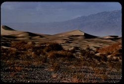
- Description:
- 100 f 7 tl
- Subject:
- Valleys, Death Valley (Calif. and Nev.), Mountains, Shrubs, and Dunes
- Series:
- 3-55
- Creator:
- Cushman, Charles W., 1896-1972
- Date Created:
- 1955-02-27
- Genre:
- Landscape photographs
- Frame Number:
- 25
- County:
- Inyo
- Abstract:
- Sand Dunes near Stove Pipe Wells
- Call Number:
- P07616
- City:
- Stovepipe Wells
- Country:
- United States
- State/Province:
- California
- Alternate Identifier:
- 355.25
- Persistent URL:
- http://purl.dlib.indiana.edu/iudl/archives/cushman/P07616
- Holding Location:
- Bloomington - University Archives
Wells Library E460
1320 E 10th St.
Bloomington, IN 47405
Contact at archives@indiana.edu, 812-855-1127
-
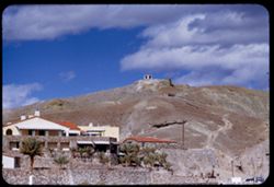
- Description:
- 200 f 5.6 tl
- Subject:
- Valleys, Resorts, Automobiles, Trees, Chimneys, Arches, Mountains, Furnace Creek Inn (Death Valley Junction, Calif.), Hotels, Masonry, Death Valley (Calif. a...
- Series:
- 3-55
- Creator:
- Cushman, Charles W., 1896-1972
- Date Created:
- 1955-02-27
- Frame Number:
- 23
- County:
- Inyo
- Abstract:
- Furnace Ck. Inn
- Call Number:
- P07614
- City:
- Death Valley Junction
- Country:
- United States
- State/Province:
- California
- Alternate Identifier:
- 355.23
- Persistent URL:
- http://purl.dlib.indiana.edu/iudl/archives/cushman/P07614
- Holding Location:
- Bloomington - University Archives
Wells Library E460
1320 E 10th St.
Bloomington, IN 47405
Contact at archives@indiana.edu, 812-855-1127
-
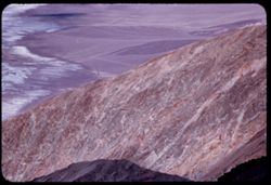
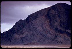
- Description:
- 100 f 6.3 tl
- Subject:
- Black Mountains (Inyo County, Calif.), Death Valley (Calif. and Nev.), Mountains, Rocks, Clouds, and Rock formations
- Series:
- 3-55
- Creator:
- Cushman, Charles W., 1896-1972
- Date Created:
- 1955-02-27
- Genre:
- Landscape photographs
- Frame Number:
- 22
- Street Address:
- Bad Water Road
- County:
- Inyo
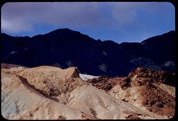
- Abstract:
- Red stripe across Black Mtns
- Call Number:
- P07613
- Country:
- United States
- State/Province:
- California
- Alternate Identifier:
- 355.22
- Persistent URL:
- http://purl.dlib.indiana.edu/iudl/archives/cushman/P07613
- Holding Location:
- Bloomington - University Archives
Wells Library E460
1320 E 10th St.
Bloomington, IN 47405
Contact at archives@indiana.edu, 812-855-1127
-
- Description:
- 100 f 5.6
- Subject:
- Canyons, Mountains, Death Valley (Calif. and Nev.), and Desolation Canyon (Calif.)
- Series:
- 3-55
- Creator:
- Cushman, Charles W., 1896-1972
- Date Created:
- 1955-02-27
- Genre:
- Landscape photographs
- Frame Number:
- 19
- Street Address:
- Bad Water Road
- County:
- Inyo
- Abstract:
- Toward Desolation canyon
- Call Number:
- P07611
- Country:
- United States
- State/Province:
- California
- Alternate Identifier:
- 355.19
- Persistent URL:
- http://purl.dlib.indiana.edu/iudl/archives/cushman/P07611
- Holding Location:
- Bloomington - University Archives
Wells Library E460
1320 E 10th St.
Bloomington, IN 47405
Contact at archives@indiana.edu, 812-855-1127
-
- Description:
- 100 f 6.3
- Subject:
- Canyons, Valleys, Black Mountains (Inyo County, Calif.), and Mountains
- Series:
- 3-55
- Creator:
- Cushman, Charles W., 1896-1972
- Date Created:
- 1955-02-27
- Genre:
- Landscape photographs
- Frame Number:
- 17
- Street Address:
- Bad Water Road
- County:
- Inyo
- Abstract:
- From a mile or two farther south
- Call Number:
- P07609
- Country:
- United States
- State/Province:
- California
- Alternate Identifier:
- 355.17
- Persistent URL:
- http://purl.dlib.indiana.edu/iudl/archives/cushman/P07609
- Holding Location:
- Bloomington - University Archives
Wells Library E460
1320 E 10th St.
Bloomington, IN 47405
Contact at archives@indiana.edu, 812-855-1127
-
- Description:
- 100 f 6.3 tl
- Subject:
- Valleys, Mountains, and Black Mountains (Inyo County, Calif.)
- Series:
- 3-55
- Creator:
- Cushman, Charles W., 1896-1972
- Date Created:
- 1955-02-27
- Genre:
- Landscape photographs
- Frame Number:
- 16
- Street Address:
- Bad Water Road
- County:
- Inyo
- Abstract:
- W slope of Black Mtns from Bad Water Rd.
- Call Number:
- P07608
- Country:
- United States
- State/Province:
- California
- Alternate Identifier:
- 355.16
- Persistent URL:
- http://purl.dlib.indiana.edu/iudl/archives/cushman/P07608
- Holding Location:
- Bloomington - University Archives
Wells Library E460
1320 E 10th St.
Bloomington, IN 47405
Contact at archives@indiana.edu, 812-855-1127
-
- Description:
- 200 f 5.6 tl
- Subject:
- Valleys, Funeral Mountains (Calif.), Mountains, Death Valley National Park (Calif. and Nev.), Shadows, and Clouds
- Series:
- 3-55
- Creator:
- Cushman, Charles W., 1896-1972
- Date Created:
- 1955-02-27
- Genre:
- Landscape photographs
- Frame Number:
- 10
- County:
- Inyo
- Abstract:
- Funeral Mtns.
- Call Number:
- P07602
- Country:
- United States
- State/Province:
- California
- Alternate Identifier:
- 355.10
- Persistent URL:
- http://purl.dlib.indiana.edu/iudl/archives/cushman/P07602
- Holding Location:
- Bloomington - University Archives
Wells Library E460
1320 E 10th St.
Bloomington, IN 47405
Contact at archives@indiana.edu, 812-855-1127
-
- Description:
- 100 f 6.3
- Subject:
- Valleys, Mountains, Clouds, and Death Valley National Park (Calif. and Nev.)
- Series:
- 3-55
- Creator:
- Cushman, Charles W., 1896-1972
- Date Created:
- 1955-02-27
- Genre:
- Landscape photographs
- Frame Number:
- 9
- County:
- Inyo
- Abstract:
- Closer view of same
- Call Number:
- P07601
- City:
- Ryan
- Country:
- United States
- State/Province:
- California
- Alternate Identifier:
- 355.9
- Persistent URL:
- http://purl.dlib.indiana.edu/iudl/archives/cushman/P07601
- Holding Location:
- Bloomington - University Archives
Wells Library E460
1320 E 10th St.
Bloomington, IN 47405
Contact at archives@indiana.edu, 812-855-1127
-
- Description:
- 200 f 4.5 tl
- Subject:
- Valleys, Mountains, Clouds, and Death Valley National Park (Calif. and Nev.)
- Series:
- 3-55
- Creator:
- Cushman, Charles W., 1896-1972
- Date Created:
- 1955-02-27
- Genre:
- Landscape photographs
- Frame Number:
- 7
- County:
- Inyo
- Abstract:
- Brown & mauve mtns near Ryan
- Call Number:
- P07600
- City:
- Ryan
- Country:
- United States
- State/Province:
- California
- Alternate Identifier:
- 355.7
- Persistent URL:
- http://purl.dlib.indiana.edu/iudl/archives/cushman/P07600
- Holding Location:
- Bloomington - University Archives
Wells Library E460
1320 E 10th St.
Bloomington, IN 47405
Contact at archives@indiana.edu, 812-855-1127
-
- Description:
- 100 f 8 tl
- Subject:
- Rocks, Valleys, Dantes View (Calif.), Mountains, Shrubs, Clouds, Death Valley National Park (Calif. and Nev.), and Black Mountains (Inyo County, Calif.)
- Series:
- 3-55
- Creator:
- Cushman, Charles W., 1896-1972
- Date Created:
- 1955-02-27
- Genre:
- Landscape photographs
- Frame Number:
- 6
- County:
- Inyo
- Abstract:
- East side of Black Mtns from road below Dante's View from another angle.
- Call Number:
- P07599
- Country:
- United States
- State/Province:
- California
- Alternate Identifier:
- 355.6
- Persistent URL:
- http://purl.dlib.indiana.edu/iudl/archives/cushman/P07599
- Holding Location:
- Bloomington - University Archives
Wells Library E460
1320 E 10th St.
Bloomington, IN 47405
Contact at archives@indiana.edu, 812-855-1127
-
- Description:
- 100 f 8 tl
- Subject:
- Valleys, Dantes View (Calif.), Mountains, Shrubs, Death Valley (Calif. and Nev.), and Black Mountains (Inyo County, Calif.)
- Series:
- 3-55
- Creator:
- Cushman, Charles W., 1896-1972
- Date Created:
- 1955-02-27
- Genre:
- Landscape photographs
- Frame Number:
- 5
- County:
- Inyo
- Abstract:
- East side of Black Mtns from road below Dante's View
- Call Number:
- P07598
- Country:
- United States
- State/Province:
- California
- Alternate Identifier:
- 355.5
- Persistent URL:
- http://purl.dlib.indiana.edu/iudl/archives/cushman/P07598
- Holding Location:
- Bloomington - University Archives
Wells Library E460
1320 E 10th St.
Bloomington, IN 47405
Contact at archives@indiana.edu, 812-855-1127
-
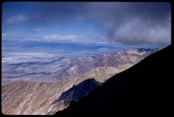
- Description:
- 50 mm lens
- Subject:
- Deserts, Craters, Valleys, Dantes View (Calif.), Mountains, Clouds, Death Valley (Calif. and Nev.), and Black Mountains (Inyo County, Calif.)
- Series:
- 3-55
- Creator:
- Cushman, Charles W., 1896-1972
- Date Created:
- 1955-02-27
- Genre:
- Landscape photographs
- Frame Number:
- 4
- County:
- Inyo
- Abstract:
- West across floor of Death Valley
- Call Number:
- P07597
- Country:
- United States
- State/Province:
- California
- Alternate Identifier:
- 355.4
- Persistent URL:
- http://purl.dlib.indiana.edu/iudl/archives/cushman/P07597
- Holding Location:
- Bloomington - University Archives
Wells Library E460
1320 E 10th St.
Bloomington, IN 47405
Contact at archives@indiana.edu, 812-855-1127
-
- Description:
- 50 mm lens
- Subject:
- Valleys, Dantes View (Calif.), Mountains, Death Valley (Calif. and Nev.), Black Mountains (Inyo County, Calif.), and Clouds
- Series:
- 3-55
- Creator:
- Cushman, Charles W., 1896-1972
- Date Created:
- 1955-02-27
- Genre:
- Landscape photographs
- Frame Number:
- 3
- County:
- Inyo
- Abstract:
- View north along ridge of Black Mtns
- Call Number:
- P07596
- Country:
- United States
- State/Province:
- California
- Alternate Identifier:
- 355.3
- Persistent URL:
- http://purl.dlib.indiana.edu/iudl/archives/cushman/P07596
- Holding Location:
- Bloomington - University Archives
Wells Library E460
1320 E 10th St.
Bloomington, IN 47405
Contact at archives@indiana.edu, 812-855-1127
-
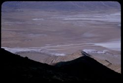
- Description:
- tl
- Subject:
- Valleys, Roads, Dantes View (Calif.), Black Mountain (Inyo County, Calif.), Clouds, Death Valley (Calif. and Nev.), and Mountains
- Series:
- 2-55
- Creator:
- Cushman, Charles W., 1896-1972
- Date Created:
- 1955-02-27
- Genre:
- Landscape photographs
- Frame Number:
- 37
- County:
- Inyo
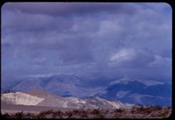
- Abstract:
- Up valley - NNW.
- Call Number:
- P07594
- Country:
- United States
- State/Province:
- California
- Alternate Identifier:
- 255.37
- Persistent URL:
- http://purl.dlib.indiana.edu/iudl/archives/cushman/P07594
- Holding Location:
- Bloomington - University Archives
Wells Library E460
1320 E 10th St.
Bloomington, IN 47405
Contact at archives@indiana.edu, 812-855-1127
-
- Description:
- tl
- Subject:
- Valleys, Black Mountains (Inyo County, Calif.), Death Valley (Calif. and Nev.), Roads, Mountains, Clouds, and Dantes View (Calif.)
- Series:
- 2-55
- Creator:
- Cushman, Charles W., 1896-1972
- Date Created:
- 1955-02-27
- Genre:
- Landscape photographs
- Frame Number:
- 36
- County:
- Inyo
- Abstract:
- Floor of valley 5,475 ft. below Dante's View in Black Mtns.
- Call Number:
- P07593
- Country:
- United States
- State/Province:
- California
- Alternate Identifier:
- 255.36
- Persistent URL:
- http://purl.dlib.indiana.edu/iudl/archives/cushman/P07593
- Holding Location:
- Bloomington - University Archives
Wells Library E460
1320 E 10th St.
Bloomington, IN 47405
Contact at archives@indiana.edu, 812-855-1127
-
- Description:
- tl
- Subject:
- Valleys, Panamint Range (Calif.), Dantes View (Calif.), Mountains, Clouds, and Death Valley (Calif. and Nev.)
- Series:
- 2-55
- Creator:
- Cushman, Charles W., 1896-1972
- Date Created:
- 1955-02-27
- Genre:
- Landscape photographs
- Frame Number:
- 35
- County:
- Inyo
- Abstract:
- West by north across valley toward Panamints
- Call Number:
- P07592
- Country:
- United States
- State/Province:
- California
- Alternate Identifier:
- 255.35
- Persistent URL:
- http://purl.dlib.indiana.edu/iudl/archives/cushman/P07592
- Holding Location:
- Bloomington - University Archives
Wells Library E460
1320 E 10th St.
Bloomington, IN 47405
Contact at archives@indiana.edu, 812-855-1127
-
- Description:
- tl
- Subject:
- Valleys, Dantes View (Calif.), Mountains, Clouds, Death Valley (Calif. and Nev.), and Black Mountains (Inyo County, Calif.)
- Series:
- 2-55
- Creator:
- Cushman, Charles W., 1896-1972
- Date Created:
- 1955-02-27
- Genre:
- Landscape photographs
- Frame Number:
- 34
- County:
- Inyo
- Abstract:
- Northward over tops of Black Mtns.
- Call Number:
- P07591
- Country:
- United States
- State/Province:
- California
- Alternate Identifier:
- 255.34
- Persistent URL:
- http://purl.dlib.indiana.edu/iudl/archives/cushman/P07591
- Holding Location:
- Bloomington - University Archives
Wells Library E460
1320 E 10th St.
Bloomington, IN 47405
Contact at archives@indiana.edu, 812-855-1127
-
- Description:
- tl
- Subject:
- Valleys, Dantes View (Calif.), Mountains, Clouds, and Death Valley (Calif. and Nev.)
- Series:
- 2-55
- Creator:
- Cushman, Charles W., 1896-1972
- Date Created:
- 1955-02-27
- Genre:
- Landscape photographs
- Frame Number:
- 33
- County:
- Inyo
- Abstract:
- Cloud-flecked floor of Death Valley NNW of Dante's View
- Call Number:
- P07590
- Country:
- United States
- State/Province:
- California
- Alternate Identifier:
- 255.33
- Persistent URL:
- http://purl.dlib.indiana.edu/iudl/archives/cushman/P07590
- Holding Location:
- Bloomington - University Archives
Wells Library E460
1320 E 10th St.
Bloomington, IN 47405
Contact at archives@indiana.edu, 812-855-1127
-
- Description:
- 100 f 5.6 tl
- Subject:
- Rocks, Dantes View (Calif.), Mountains, Shrubs, Clouds, Death Valley (Calif. and Nev.), and Black Mountains (Inyo County, Calif.)
- Series:
- 2-55
- Creator:
- Cushman, Charles W., 1896-1972
- Date Created:
- 1955-02-27
- Genre:
- Landscape photographs
- Frame Number:
- 32
- County:
- Inyo
- Abstract:
- Black Mtns on way to Dante's View from road near Ryan
- Call Number:
- P07589
- City:
- Ryan
- Country:
- United States
- State/Province:
- California
- Alternate Identifier:
- 255.32
- Persistent URL:
- http://purl.dlib.indiana.edu/iudl/archives/cushman/P07589
- Holding Location:
- Bloomington - University Archives
Wells Library E460
1320 E 10th St.
Bloomington, IN 47405
Contact at archives@indiana.edu, 812-855-1127
-
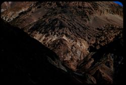
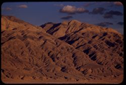
- Description:
- 100 f 6.3
- Subject:
- Rocks, Mountains, Rock formations, Clouds, and Black Mountains (Inyo County, Calif.)
- Series:
- 2-55
- Creator:
- Cushman, Charles W., 1896-1972
- Date Created:
- 1955-02-27
- Genre:
- Landscape photographs
- Frame Number:
- 31
- County:
- Inyo
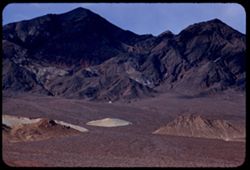
- Abstract:
- colored rock mass
- Call Number:
- P07588
- Country:
- United States
- State/Province:
- California
- Alternate Identifier:
- 255.31
- Persistent URL:
- http://purl.dlib.indiana.edu/iudl/archives/cushman/P07588
- Holding Location:
- Bloomington - University Archives
Wells Library E460
1320 E 10th St.
Bloomington, IN 47405
Contact at archives@indiana.edu, 812-855-1127
-
- Description:
- 100 f 6.3 tl
- Subject:
- Valleys, Mountains, Death Valley (Calif. and Nev.), and Black Mountains (Inyo County, Calif.)
- Series:
- 2-55
- Creator:
- Cushman, Charles W., 1896-1972
- Date Created:
- 1955-02-27
- Genre:
- Landscape photographs
- Frame Number:
- 30
- County:
- Inyo
- Abstract:
- West toward Black Mtns
- Call Number:
- P07587
- City:
- Ryan
- Country:
- United States
- State/Province:
- California
- Alternate Identifier:
- 255.30
- Persistent URL:
- http://purl.dlib.indiana.edu/iudl/archives/cushman/P07587
- Holding Location:
- Bloomington - University Archives
Wells Library E460
1320 E 10th St.
Bloomington, IN 47405
Contact at archives@indiana.edu, 812-855-1127
-
- Description:
- 100 f 8 tl
- Subject:
- Hills, Funeral Mountains (Calif.), Funeral Mountains Wilderness (Calif.), Mountains, Shrubs, Furnace Creek (Calif.), Rocks, and Clouds
- Series:
- 2-55
- Creator:
- Cushman, Charles W., 1896-1972
- Date Created:
- 1955-02-27
- Genre:
- Landscape photographs
- Frame Number:
- 29
- Street Address:
- Furance Creek-Death Valley Junction Road
- County:
- Mono and Inyo
- Abstract:
- North toward Funeral Mtns
- Call Number:
- P07586
- City:
- Death Valley Junction
- Country:
- United States
- State/Province:
- California
- Alternate Identifier:
- 255.29
- Persistent URL:
- http://purl.dlib.indiana.edu/iudl/archives/cushman/P07586
- Holding Location:
- Bloomington - University Archives
Wells Library E460
1320 E 10th St.
Bloomington, IN 47405
Contact at archives@indiana.edu, 812-855-1127
-
- Description:
- 200 f 4.5 tl
- Subject:
- Mountains, Clouds, Hills, Black Mountains (Inyo County, Calif.), and Death Valley (Calif. and Nev.)
- Series:
- 2-55
- Creator:
- Cushman, Charles W., 1896-1972
- Date Created:
- 1955-02-27
- Genre:
- Landscape photographs
- Frame Number:
- 27
- County:
- Inyo
- Abstract:
- Black Mtns from east
- Call Number:
- P07585
- Country:
- United States
- State/Province:
- California
- Alternate Identifier:
- 255.27
- Persistent URL:
- http://purl.dlib.indiana.edu/iudl/archives/cushman/P07585
- Holding Location:
- Bloomington - University Archives
Wells Library E460
1320 E 10th St.
Bloomington, IN 47405
Contact at archives@indiana.edu, 812-855-1127
-
- Description:
- 200 f 4.5 tl
- Subject:
- Rocks, Dantes View (Calif.), Mountains, Shrubs, Death Valley (Calif. and Nev.), Rock formations, and Furnace Creek Inn (Death Valley Junction, Calif.)
- Series:
- 2-55
- Creator:
- Cushman, Charles W., 1896-1972
- Date Created:
- 1955-02-27
- Genre:
- Landscape photographs
- Frame Number:
- 26
- County:
- Inyo
- Abstract:
- Elephant hide 10 miles SE of Furnace Ck. Inn
- Call Number:
- P07584
- City:
- Death Valley Junction
- Country:
- United States
- State/Province:
- California
- Alternate Identifier:
- 255.26
- Persistent URL:
- http://purl.dlib.indiana.edu/iudl/archives/cushman/P07584
- Holding Location:
- Bloomington - University Archives
Wells Library E460
1320 E 10th St.
Bloomington, IN 47405
Contact at archives@indiana.edu, 812-855-1127
-
- Description:
- 100 f 4 tl
- Subject:
- Furnace Creek Inn (Death Valley Junction, Calif.), Death Valley (Calif. and Nev.), Funeral Mountains (Calif.), Mountains, Shrubs, Rock formations, and Clouds
- Series:
- 2-55
- Creator:
- Cushman, Charles W., 1896-1972
- Date Created:
- 1955-02-27
- Genre:
- Landscape photographs
- Frame Number:
- 25
- County:
- Inyo
- Abstract:
- Funeral Mtn in overcast between D.V. Juctn and Furnace Ck. Inn
- Call Number:
- P07583
- City:
- Death Valley Junction
- Country:
- United States
- State/Province:
- California
- Alternate Identifier:
- 255.25
- Persistent URL:
- http://purl.dlib.indiana.edu/iudl/archives/cushman/P07583
- Holding Location:
- Bloomington - University Archives
Wells Library E460
1320 E 10th St.
Bloomington, IN 47405
Contact at archives@indiana.edu, 812-855-1127
-
- Description:
- 100 f 5.6 tl
- Subject:
- Roads, Mountains, Clouds, and Panamint Range (Calif.)
- Series:
- 2-55
- Creator:
- Cushman, Charles W., 1896-1972
- Date Created:
- 1955-02-26
- Genre:
- Landscape photographs
- Frame Number:
- 24
- County:
- Inyo
- Abstract:
- Panamints from west
- Call Number:
- P07582
- Country:
- United States
- State/Province:
- California
- Alternate Identifier:
- 255.24
- Persistent URL:
- http://purl.dlib.indiana.edu/iudl/archives/cushman/P07582
- Holding Location:
- Bloomington - University Archives
Wells Library E460
1320 E 10th St.
Bloomington, IN 47405
Contact at archives@indiana.edu, 812-855-1127
-
- Description:
- 100 f 6.3 tl
- Subject:
- Panamint Range (Calif.), Mountains, Clouds, and Hills
- Series:
- 2-55
- Creator:
- Cushman, Charles W., 1896-1972
- Date Created:
- 1955-02-26
- Genre:
- Landscape photographs
- Frame Number:
- 23
- Street Address:
- Trona Road
- County:
- Inyo
- Abstract:
- Panamint Mtns east of rd north from Trona
- Call Number:
- P07581
- Country:
- United States
- State/Province:
- California
- Alternate Identifier:
- 255.23
- Persistent URL:
- http://purl.dlib.indiana.edu/iudl/archives/cushman/P07581
- Holding Location:
- Bloomington - University Archives
Wells Library E460
1320 E 10th St.
Bloomington, IN 47405
Contact at archives@indiana.edu, 812-855-1127
-
- Description:
- 100 f 6.3 tl
- Subject:
- Valleys, Mountains, Snow, Clouds, and Panamint Range (Calif.)
- Series:
- 2-55
- Creator:
- Cushman, Charles W., 1896-1972
- Date Created:
- 1955-02-26
- Genre:
- Landscape photographs
- Frame Number:
- 22
- Street Address:
- Trona Road
- County:
- Inyo
- Abstract:
- Panamint Mtns east of rd north from Trona
- Call Number:
- P07580
- Country:
- United States
- State/Province:
- California
- Alternate Identifier:
- 255.22
- Persistent URL:
- http://purl.dlib.indiana.edu/iudl/archives/cushman/P07580
- Holding Location:
- Bloomington - University Archives
Wells Library E460
1320 E 10th St.
Bloomington, IN 47405
Contact at archives@indiana.edu, 812-855-1127
-
- Description:
- 50 f 11 HF
- Subject:
- Deserts, Inyo Mountains (Calif.), Flowers, Mountains, Shrubs, Hills, and Rock formations
- Series:
- 12-54
- Creator:
- Cushman, Charles W., 1896-1972
- Date Created:
- 1954-09-18
- Genre:
- Landscape photographs
- Frame Number:
- 29
- Street Address:
- Mt. Whitney Road
- County:
- Inyo
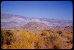
- Abstract:
- Inyo Mtns beyond one of the Alabama Hills.
- Call Number:
- P07419
- City:
- Alabama Hills and Lone Pine
- Country:
- United States
- State/Province:
- California
- Alternate Identifier:
- 1254.29
- Persistent URL:
- http://purl.dlib.indiana.edu/iudl/archives/cushman/P07419
- Holding Location:
- Bloomington - University Archives
Wells Library E460
1320 E 10th St.
Bloomington, IN 47405
Contact at archives@indiana.edu, 812-855-1127
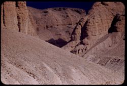
-
- Description:
- 50 f 11 HF
- Subject:
- Valleys, Inyo Mountains (Calif.), Mountains, Owens Valley (Calif.), Deserts, Shrubs, Roads, and Rocks
- Series:
- 12-54
- Creator:
- Cushman, Charles W., 1896-1972
- Date Created:
- 1954-09-18
- Genre:
- Landscape photographs
- Frame Number:
- 27
- Street Address:
- Mt. Whitney Road
- County:
- Inyo
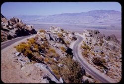
- Abstract:
- Switch-back coming down Mt Whitney rd.
- Call Number:
- P07417
- Country:
- United States
- State/Province:
- California
- Alternate Identifier:
- 1254.27
- Persistent URL:
- http://purl.dlib.indiana.edu/iudl/archives/cushman/P07417
- Holding Location:
- Bloomington - University Archives
Wells Library E460
1320 E 10th St.
Bloomington, IN 47405
Contact at archives@indiana.edu, 812-855-1127
-
- Description:
- 50 f 12 HF
- Subject:
- Deserts, Valleys, Owens Lake (Inyo County, Calif.), Flowers, Owens Valley (Calif.), Mountains, Shrubs, and Lakes & ponds
- Series:
- 12-54
- Creator:
- Cushman, Charles W., 1896-1972
- Date Created:
- 1954-09-18
- Genre:
- Landscape photographs
- Frame Number:
- 28
- Street Address:
- Mt. Whitney Road
- County:
- Inyo
- Abstract:
- Owens Lake.
- Call Number:
- P07418
- Country:
- United States
- State/Province:
- California
- Alternate Identifier:
- 1254.28
- Persistent URL:
- http://purl.dlib.indiana.edu/iudl/archives/cushman/P07418
- Holding Location:
- Bloomington - University Archives
Wells Library E460
1320 E 10th St.
Bloomington, IN 47405
Contact at archives@indiana.edu, 812-855-1127
-
- Subject:
- Rocks, Trails & paths, Trees, Mountains, Shrubs, and Whitney, Mount (Calif.)
- Series:
- 12-54
- Creator:
- Cushman, Charles W., 1896-1972
- Date Created:
- 1954-09-17
- Genre:
- Landscape photographs
- Frame Number:
- 26
- Street Address:
- Mt. Whitney Road
- County:
- Inyo
- Abstract:
- Looking back at Mt. Whitney from high up Mt. Whitney road. Backlighted.
- Call Number:
- P07416
- Country:
- United States
- State/Province:
- California
- Physical Description:
- Image was originally mounted in a glass enclosure. Before digitization, the image was removed and placed in a Wess Plastic, Inc. brand, 2" x 2", pl...
- Alternate Identifier:
- 1254.26
- Persistent URL:
- http://purl.dlib.indiana.edu/iudl/archives/cushman/P07416
- Holding Location:
- Bloomington - University Archives
Wells Library E460
1320 E 10th St.
Bloomington, IN 47405
Contact at archives@indiana.edu, 812-855-1127
-
- Description:
- 50 f 12 HF
- Subject:
- Rocks, Valleys, Owens Lake (Inyo County, Calif.), Owens Valley (Calif.), Mountains, Shrubs, Lakes & ponds, Deserts, Trees, and Rock formations
- Series:
- 12-54
- Creator:
- Cushman, Charles W., 1896-1972
- Date Created:
- 1954-09-18
- Genre:
- Landscape photographs
- Frame Number:
- 25
- Street Address:
- Mt. Whitney Road
- County:
- Inyo
- Abstract:
- Owens Dry Lake from high up Mt Whitney rd.
- Call Number:
- P07415
- Country:
- United States
- State/Province:
- California
- Alternate Identifier:
- 1254.25
- Persistent URL:
- http://purl.dlib.indiana.edu/iudl/archives/cushman/P07415
- Holding Location:
- Bloomington - University Archives
Wells Library E460
1320 E 10th St.
Bloomington, IN 47405
Contact at archives@indiana.edu, 812-855-1127
-
- Description:
- 50 f 12 HF
- Subject:
- Rocks, Valleys, Inyo Mountains (Calif.), Trees, Owens Valley (Calif.), Mountains, and Shrubs
- Series:
- 12-54
- Creator:
- Cushman, Charles W., 1896-1972
- Date Created:
- 1954-09-18
- Genre:
- Landscape photographs
- Frame Number:
- 24
- Street Address:
- Mt. Whitney Road
- County:
- Inyo
- Abstract:
- Owens Valley from high up Mt Whitney Rd.
- Call Number:
- P07414
- Country:
- United States
- State/Province:
- California
- Alternate Identifier:
- 1254.24
- Persistent URL:
- http://purl.dlib.indiana.edu/iudl/archives/cushman/P07414
- Holding Location:
- Bloomington - University Archives
Wells Library E460
1320 E 10th St.
Bloomington, IN 47405
Contact at archives@indiana.edu, 812-855-1127
-
- Description:
- 50 f 7.5
- Subject:
- Roads, Whitney, Mount (Calif.), Mountains, Shrubs, Trees, and Rocks
- Series:
- 12-54
- Creator:
- Cushman, Charles W., 1896-1972
- Date Created:
- 1954-09-18
- Genre:
- Landscape photographs
- Frame Number:
- 23
- Street Address:
- Mt. Whitney Road
- County:
- Inyo
- Abstract:
- Closest to Mt Whitney - backlighted.
- Call Number:
- P07413
- Country:
- United States
- State/Province:
- California
- Physical Description:
- Image was originally mounted in a glass enclosure. Before digitization, the image was removed and placed in a Wess Plastic, Inc. brand, 2" x 2", pl...
- Alternate Identifier:
- 1254.23
- Persistent URL:
- http://purl.dlib.indiana.edu/iudl/archives/cushman/P07413
- Holding Location:
- Bloomington - University Archives
Wells Library E460
1320 E 10th St.
Bloomington, IN 47405
Contact at archives@indiana.edu, 812-855-1127
-
- Description:
- ?
- Subject:
- Hills, Automobiles, Whitney, Mount (Calif.), Mountains, Shrubs, Trees, Buildings, Dwellings, and Rocks
- Series:
- 12-54
- Creator:
- Cushman, Charles W., 1896-1972
- Date Created:
- 1954-09-18
- Genre:
- Landscape photographs
- Frame Number:
- 21
- Street Address:
- Mt. Whitney Road
- County:
- Inyo
- Abstract:
- Mt. Whitney revisited.
- Call Number:
- P07411
- City:
- Lone Pine
- Country:
- United States
- State/Province:
- California
- Alternate Identifier:
- 1254.21
- Persistent URL:
- http://purl.dlib.indiana.edu/iudl/archives/cushman/P07411
- Holding Location:
- Bloomington - University Archives
Wells Library E460
1320 E 10th St.
Bloomington, IN 47405
Contact at archives@indiana.edu, 812-855-1127
-
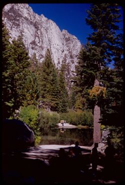
- Description:
- 50 f 9
- Subject:
- Bodies of water, Trees, Boulders, Shadows, Mountains, Shrubs, Lakes & ponds, Whitney, Mount (Calif.), People, and Reflections
- Series:
- 12-54
- Creator:
- Cushman, Charles W., 1896-1972
- Date Created:
- 1954-09-18
- Genre:
- Landscape photographs
- Frame Number:
- 22
- Street Address:
- Mt. Whitney Road
- County:
- Inyo
- Abstract:
- Vacationers at Mt Whitney Portal campground.
- Call Number:
- P07412
- Country:
- United States
- State/Province:
- California
- Alternate Identifier:
- 1254.22
- Persistent URL:
- http://purl.dlib.indiana.edu/iudl/archives/cushman/P07412
- Holding Location:
- Bloomington - University Archives
Wells Library E460
1320 E 10th St.
Bloomington, IN 47405
Contact at archives@indiana.edu, 812-855-1127
-
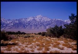
- Description:
- 50 f 11
- Subject:
- Deserts, Williamson, Mount (Inyo County, Calif.), Sand, Mountains, Shrubs, and Trees
- Series:
- 12-54
- Creator:
- Cushman, Charles W., 1896-1972
- Date Created:
- 1954-09-18
- Genre:
- Landscape photographs
- Frame Number:
- 20
- Street Address:
- United States Highway 6
- County:
- Inyo
- Abstract:
- Mt. Williamson, 14,384.
- Call Number:
- P07410
- City:
- Independence
- Country:
- United States
- State/Province:
- California
- Physical Description:
- Image was originally mounted in a glass enclosure. Before digitization, the image was removed and placed in a Wess Plastic, Inc. brand, 2" x 2", pl...
- Alternate Identifier:
- 1254.20
- Persistent URL:
- http://purl.dlib.indiana.edu/iudl/archives/cushman/P07410
- Holding Location:
- Bloomington - University Archives
Wells Library E460
1320 E 10th St.
Bloomington, IN 47405
Contact at archives@indiana.edu, 812-855-1127
-
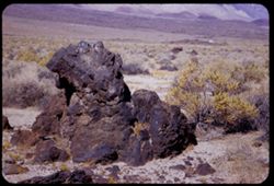
- Description:
- 50 f 8 HF
- Subject:
- Deserts, Owens Valley (Calif.), Rocks, Igneous, Mountains, Shrubs, Sierra Nevada (Calif. and Nev.), Rocks, and Rock formations
- Series:
- 12-54
- Creator:
- Cushman, Charles W., 1896-1972
- Date Created:
- 1954-09-18
- Genre:
- Landscape photographs
- Frame Number:
- 19
- County:
- Inyo
- Abstract:
- Big hunk of lava.
- Call Number:
- P07409
- City:
- Independence and Big Pine
- Country:
- United States
- State/Province:
- California
- Alternate Identifier:
- 1254.19
- Persistent URL:
- http://purl.dlib.indiana.edu/iudl/archives/cushman/P07409
- Holding Location:
- Bloomington - University Archives
Wells Library E460
1320 E 10th St.
Bloomington, IN 47405
Contact at archives@indiana.edu, 812-855-1127