
Search Constraints
You searched for:
Campus
IUB
Remove constraint Campus: IUB
County
Inyo
Remove constraint County: Inyo
Subject
Deserts
Remove constraint Subject: Deserts
1 - 54 of 54
Search Results
-
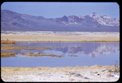
- Description:
- 100 f 6 tl
- Subject:
- Lakes & ponds, Deserts, Reflections, Valleys, Black Mountains (Inyo County, Calif.), Death Valley (Calif. and Nev.), Mountains, and Shrubs
- Series:
- 12-55
- Creator:
- Cushman, Charles W., 1896-1972
- Date Created:
- 1955-03-24
- Genre:
- Landscape photographs
- Frame Number:
- 8
- County:
- Inyo
- Abstract:
- Desert lake near Tecopa - view N.W.
- Call Number:
- P07904
- City:
- Tecopa
- Country:
- United States
- State/Province:
- California
- Alternate Identifier:
- 1255.8
- Persistent URL:
- http://purl.dlib.indiana.edu/iudl/archives/cushman/P07904
-
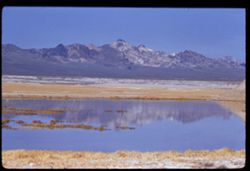
- Description:
- 100 f 8 tl
- Subject:
- Lakes & ponds, Deserts, Reflections, Valleys, Black Mountains (Inyo County, Calif.), Death Valley (Calif. and Nev.), Mountains, and Shrubs
- Series:
- 12-55
- Creator:
- Cushman, Charles W., 1896-1972
- Date Created:
- 1955-03-24
- Genre:
- Landscape photographs
- Frame Number:
- 7
- County:
- Inyo
- Abstract:
- Desert lake near Tecopa - view N.W.
- Call Number:
- P07903
- City:
- Tecopa
- Country:
- United States
- State/Province:
- California
- Alternate Identifier:
- 1255.7
- Persistent URL:
- http://purl.dlib.indiana.edu/iudl/archives/cushman/P07903
-
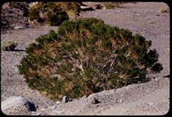
- Description:
- 100 f 6.3 tl 35 ft
- Subject:
- Deserts, Death Valley National Park (Calif. and Nev.), Furnace Creek Wash (Calif.), Shrubs, and Rocks
- Series:
- 10-55
- Creator:
- Cushman, Charles W., 1896-1972
- Date Created:
- 1955-03-23
- Genre:
- Identification photographs
- Frame Number:
- 25
- County:
- Inyo
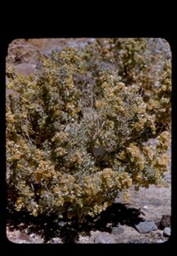
- Abstract:
- Desert bush
- Call Number:
- P07850
- Country:
- United States
- State/Province:
- California
- Alternate Identifier:
- 1055.25
- Persistent URL:
- http://purl.dlib.indiana.edu/iudl/archives/cushman/P07850
-
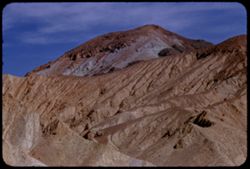
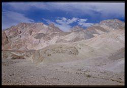
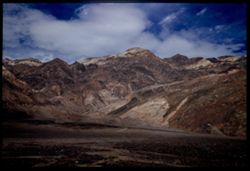
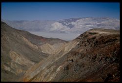
- Description:
- 100 f 8 tl
- Subject:
- Deserts, Valleys, Black Mountains (Inyo County, Calif.), Death Valley (Calif. and Nev.), Mountains, Shrubs, and Furnace Creek (Calif.)
- Series:
- 9-55
- Creator:
- Cushman, Charles W., 1896-1972
- Date Created:
- 1955-03-22
- Genre:
- Landscape photographs
- Frame Number:
- 26
- Street Address:
- Furnace Creek-Bad Water Road
- County:
- Mono and Inyo
- Abstract:
- From Bad Water road near exit to Golden Canyon
- Call Number:
- P07817
- City:
- Badwater
- Country:
- United States
- State/Province:
- California
- Alternate Identifier:
- 955.26
- Persistent URL:
- http://purl.dlib.indiana.edu/iudl/archives/cushman/P07817
-
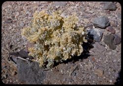
- Description:
- 100 f 8 tl 12 ft.
- Subject:
- Rocks, Holly, Furnace Creek Wash (Calif.), and Deserts
- Series:
- 9-55
- Creator:
- Cushman, Charles W., 1896-1972
- Date Created:
- 1955-03-22
- Genre:
- Identification photographs
- Frame Number:
- 14
- County:
- Inyo
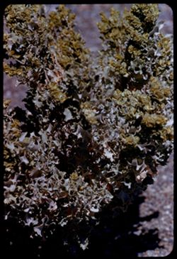
- Abstract:
- Desert holly blooming
- Call Number:
- P07806
- Country:
- United States
- State/Province:
- California
- Physical Description:
- masked.
- Alternate Identifier:
- 955.14
- Persistent URL:
- http://purl.dlib.indiana.edu/iudl/archives/cushman/P07806
-
- Description:
- 100 f 8 tl 5 1/2 ft
- Subject:
- Deserts, Holly, and Furnace Creek Wash (Calif.)
- Series:
- 9-55
- Creator:
- Cushman, Charles W., 1896-1972
- Date Created:
- 1955-03-22
- Genre:
- Identification photographs
- Frame Number:
- 6
- County:
- Inyo
- Abstract:
- Desert Holly
- Call Number:
- P07798
- Country:
- United States
- State/Province:
- California
- Alternate Identifier:
- 955.6
- Persistent URL:
- http://purl.dlib.indiana.edu/iudl/archives/cushman/P07798
-
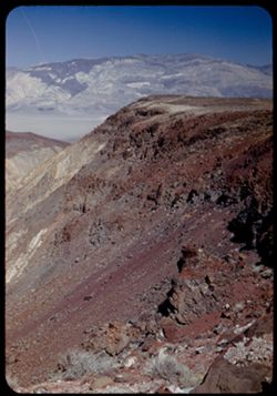
- Description:
- 50 mm lens
- Subject:
- Deserts, Craters, Valleys, Dantes View (Calif.), Mountains, Clouds, Death Valley (Calif. and Nev.), and Black Mountains (Inyo County, Calif.)
- Series:
- 3-55
- Creator:
- Cushman, Charles W., 1896-1972
- Date Created:
- 1955-02-27
- Genre:
- Landscape photographs
- Frame Number:
- 4
- County:
- Inyo
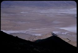
- Abstract:
- West across floor of Death Valley
- Call Number:
- P07597
- Country:
- United States
- State/Province:
- California
- Alternate Identifier:
- 355.4
- Persistent URL:
- http://purl.dlib.indiana.edu/iudl/archives/cushman/P07597
-
- Description:
- 50 f 11 HF
- Subject:
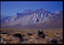
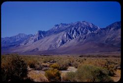
- Deserts, Inyo Mountains (Calif.), Flowers, Mountains, Shrubs, Hills, and Rock formations
- Series:
- 12-54
- Creator:
- Cushman, Charles W., 1896-1972
- Date Created:
- 1954-09-18
- Genre:
- Landscape photographs
- Frame Number:
- 29
- Street Address:
- Mt. Whitney Road
- County:
- Inyo
- Abstract:
- Inyo Mtns beyond one of the Alabama Hills.
- Call Number:
- P07419
- City:
- Alabama Hills and Lone Pine
- Country:
- United States
- State/Province:
- California
- Alternate Identifier:
- 1254.29
- Persistent URL:
- http://purl.dlib.indiana.edu/iudl/archives/cushman/P07419
-
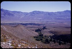
- Description:
- 50 f 11 HF
- Subject:
- Valleys, Inyo Mountains (Calif.), Mountains, Owens Valley (Calif.), Deserts, Shrubs, Roads, and Rocks
- Series:
- 12-54
- Creator:
- Cushman, Charles W., 1896-1972
- Date Created:
- 1954-09-18
- Genre:
- Landscape photographs
- Frame Number:
- 27
- Street Address:
- Mt. Whitney Road
- County:
- Inyo
- Abstract:
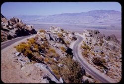
- Switch-back coming down Mt Whitney rd.
- Call Number:
- P07417
- Country:
- United States
- State/Province:
- California
- Alternate Identifier:
- 1254.27
- Persistent URL:
- http://purl.dlib.indiana.edu/iudl/archives/cushman/P07417
-
- Description:
- 50 f 12 HF
- Subject:
- Deserts, Valleys, Owens Lake (Inyo County, Calif.), Flowers, Owens Valley (Calif.), Mountains, Shrubs, and Lakes & ponds
- Series:
- 12-54
- Creator:
- Cushman, Charles W., 1896-1972
- Date Created:
- 1954-09-18
- Genre:
- Landscape photographs
- Frame Number:
- 28
- Street Address:
- Mt. Whitney Road
- County:
- Inyo
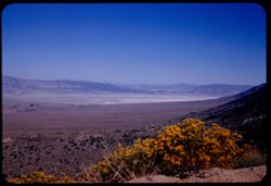
- Abstract:
- Owens Lake.
- Call Number:
- P07418
- Country:
- United States
- State/Province:
- California
- Alternate Identifier:
- 1254.28
- Persistent URL:
- http://purl.dlib.indiana.edu/iudl/archives/cushman/P07418
-
- Description:
- 50 f 12 HF
- Subject:
- Rocks, Valleys, Owens Lake (Inyo County, Calif.), Owens Valley (Calif.), Mountains, Shrubs, Lakes & ponds, Deserts, Trees, and Rock formations
- Series:
- 12-54
- Creator:
- Cushman, Charles W., 1896-1972
- Date Created:
- 1954-09-18
- Genre:
- Landscape photographs
- Frame Number:
- 25
- Street Address:
- Mt. Whitney Road
- County:
- Inyo
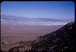
- Abstract:
- Owens Dry Lake from high up Mt Whitney rd.
- Call Number:
- P07415
- Country:
- United States
- State/Province:
- California
- Alternate Identifier:
- 1254.25
- Persistent URL:
- http://purl.dlib.indiana.edu/iudl/archives/cushman/P07415
-
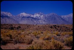
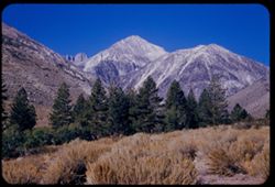
- Description:
- 50 f 11
- Subject:
- Deserts, Williamson, Mount (Inyo County, Calif.), Sand, Mountains, Shrubs, and Trees
- Series:
- 12-54
- Creator:
- Cushman, Charles W., 1896-1972
- Date Created:
- 1954-09-18
- Genre:
- Landscape photographs
- Frame Number:
- 20
- Street Address:
- United States Highway 6
- County:
- Inyo
- Abstract:
- Mt. Williamson, 14,384.
- Call Number:
- P07410
- City:
- Independence
- Country:
- United States
- State/Province:
- California
- Physical Description:
- Image was originally mounted in a glass enclosure. Before digitization, the image was removed and placed in a Wess Plastic, Inc. brand, 2" x 2", pl...
- Alternate Identifier:
- 1254.20
- Persistent URL:
- http://purl.dlib.indiana.edu/iudl/archives/cushman/P07410
-
- Description:
- 50 f 8 HF
- Subject:
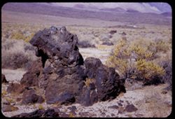
- Deserts, Owens Valley (Calif.), Rocks, Igneous, Mountains, Shrubs, Sierra Nevada (Calif. and Nev.), Rocks, and Rock formations
- Series:
- 12-54
- Creator:
- Cushman, Charles W., 1896-1972
- Date Created:
- 1954-09-18
- Genre:
- Landscape photographs
- Frame Number:
- 19
- County:
- Inyo
- Abstract:
- Big hunk of lava.
- Call Number:
- P07409
- City:
- Independence and Big Pine
- Country:
- United States
- State/Province:
- California
- Alternate Identifier:
- 1254.19
- Persistent URL:
- http://purl.dlib.indiana.edu/iudl/archives/cushman/P07409
-
- Description:
- 50 f 8 HF
- Subject:
- Rocks, Rocks, Igneous, Owens Valley (Calif.), Mountains, Shrubs, Sierra Nevada (Calif. and Nev.), and Deserts
- Series:
- 12-54
- Creator:
- Cushman, Charles W., 1896-1972
- Date Created:
- 1954-09-18
- Genre:
- Landscape photographs
- Frame Number:
- 18
- County:
- Inyo
- Abstract:
- To show sawteeth - 13 mi. north of Independence. - desert showing lava rock.
- Call Number:
- P07408
- City:
- Big Pine and Independence
- Country:
- United States
- State/Province:
- California
- Physical Description:
- Image was originally mounted in a glass enclosure. Before digitization, the image was removed and placed in a Wess Plastic, Inc. brand, 2" x 2", pl...
- Alternate Identifier:
- 1254.18
- Persistent URL:
- http://purl.dlib.indiana.edu/iudl/archives/cushman/P07408
-
- Description:
- 50 f 9 HF
- Subject:
- Deserts, Owens Valley (Calif.), Mountains, Shrubs, and Sierra Nevada (Calif. and Nev.)
- Series:
- 12-54
- Creator:
- Cushman, Charles W., 1896-1972
- Date Created:
- 1954-09-18
- Genre:
- Landscape photographs
- Frame Number:
- 17
- Street Address:
- United States Highway 6 and United States Highway 395
- County:
- Inyo
- Abstract:
- To show sawteeth - 13 mi. north of Independence.
- Call Number:
- P07407
- City:
- Big Pine and Independence
- Country:
- United States
- State/Province:
- California
- Alternate Identifier:
- 1254.17
- Persistent URL:
- http://purl.dlib.indiana.edu/iudl/archives/cushman/P07407
-
- Description:
- 50 f 11
- Subject:
- Deserts, Owens Valley (Calif.), Mountains, Shrubs, and Sierra Nevada (Calif. and Nev.)
- Series:
- 12-54
- Creator:
- Cushman, Charles W., 1896-1972
- Date Created:
- 1954-09-18
- Genre:
- Landscape photographs
- Frame Number:
- 16
- County:
- Inyo
- Abstract:
- Again from a mile further south.
- Call Number:
- P07406
- City:
- Independence and Big Pine
- Country:
- United States
- State/Province:
- California
- Physical Description:
- Image was originally mounted in a glass enclosure. Before digitization, the image was removed and placed in a Wess Plastic, Inc. brand, 2" x 2", pl...
- Alternate Identifier:
- 1254.16
- Persistent URL:
- http://purl.dlib.indiana.edu/iudl/archives/cushman/P07406
-
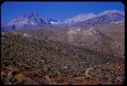
- Description:
- 50 f 11 HF
- Subject:
- Deserts, Striped Mountain (Inyo County, Calif.), Mountains, and Shrubs
- Series:
- 12-54
- Creator:
- Cushman, Charles W., 1896-1972
- Date Created:
- 1954-09-18
- Genre:
- Landscape photographs
- Frame Number:
- 15
- Street Address:
- United States Highway 395 and United States Highway 6
- County:
- Inyo
- Abstract:
- High Sierra wall including Striped Mtn. - 13,160 ft. seen from US 6 - 395 about 10 mi. south of Big Pine.
- Call Number:
- P07405
- City:
- Big Pine
- Country:
- United States
- State/Province:
- California
- Alternate Identifier:
- 1254.15
- Persistent URL:
- http://purl.dlib.indiana.edu/iudl/archives/cushman/P07405
-
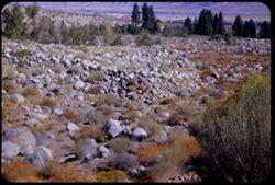
- Description:
- 50 f 9
- Subject:
- Deserts, Glacier Lodge (Calif.), Shrubs, Trees, and Rocks
- Series:
- 12-54
- Creator:
- Cushman, Charles W., 1896-1972
- Date Created:
- 1954-09-18
- Genre:
- Landscape photographs
- Frame Number:
- 14
- County:
- Inyo
- Abstract:
- Tumbled rocks in dry river bed.
- Call Number:
- P07404
- City:
- Big Pine
- Country:
- United States
- State/Province:
- California
- Alternate Identifier:
- 1254.14
- Persistent URL:
- http://purl.dlib.indiana.edu/iudl/archives/cushman/P07404
-
- Description:
- 50 f 11
- Subject:
- Deserts, Glacier Lodge (Calif.), Mountains, Shrubs, Sierra Nevada (Calif. and Nev.), and Middle Palisade Glacier (Calif.)
- Series:
- 12-54
- Creator:
- Cushman, Charles W., 1896-1972
- Date Created:
- 1954-09-18
- Genre:
- Landscape photographs
- Frame Number:
- 13
- Street Address:
- Glacier Lodge Road
- County:
- Inyo
- Abstract:
- Looking SW up Glacier Lodge road at 1020 am DST.
- Call Number:
- P07403
- City:
- Big Pine
- Country:
- United States
- State/Province:
- California
- Alternate Identifier:
- 1254.13
- Persistent URL:
- http://purl.dlib.indiana.edu/iudl/archives/cushman/P07403
-
- Description:
- 50 f 8
- Subject:
- Deserts, Valleys, Glacier Lodge (Calif.), Roads, Mountains, Shrubs, Trees, Rocks, and Owens Valley (Calif.)
- Series:
- 12-54
- Creator:
- Cushman, Charles W., 1896-1972
- Date Created:
- 1954-09-18
- Genre:
- Landscape photographs
- Frame Number:
- 12
- Street Address:
- Glacier Lodge Road
- County:
- Inyo
- Abstract:
- Looking down on Big Pine from Glacier Lodge road.
- Call Number:
- P07402
- City:
- Big Pine
- Country:
- United States
- State/Province:
- California
- Alternate Identifier:
- 1254.12
- Persistent URL:
- http://purl.dlib.indiana.edu/iudl/archives/cushman/P07402
-
- Description:
- 50 f 11
- Subject:
- Deserts, Middle Palisade Glacier (Calif.), Trees, Mountains, Shrubs, Sierra Nevada (Calif. and Nev.), and Glacier Lodge (Calif.)
- Series:
- 12-54
- Creator:
- Cushman, Charles W., 1896-1972
- Date Created:
- 1954-09-18
- Genre:
- Landscape photographs
- Frame Number:
- 11
- County:
- Inyo
- Abstract:
- Again [L]
- Call Number:
- P07401
- City:
- Lone Pine
- Country:
- United States
- State/Province:
- California
- Alternate Identifier:
- 1254.11
- Persistent URL:
- http://purl.dlib.indiana.edu/iudl/archives/cushman/P07401
-
- Description:
- 50 f 11
- Subject:
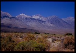
- Deserts, White Mountains (Calif. and Nev.), Owens Valley (Calif.), Mountains, and Shrubs
- Series:
- 12-54
- Creator:
- Cushman, Charles W., 1896-1972
- Date Created:
- 1954-09-17
- Genre:
- Landscape photographs
- Frame Number:
- 1
- Street Address:
- United States Highway 6
- County:
- Inyo
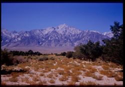
- Abstract:
- White Mtns Colorful mountain wall east side Owen Valley from US 6 about 20 mi. north of Bishop.
- Call Number:
- P07392
- City:
- Bishop
- Country:
- United States
- State/Province:
- California
- Alternate Identifier:
- 1254.1
- Persistent URL:
- http://purl.dlib.indiana.edu/iudl/archives/cushman/P07392
-
- Description:
- 50 f 11
- Subject:
- Deserts, Valleys, White Mountains (Calif. and Nev.), Dirt roads, Sand, Owens Valley (Calif.), Mountains, Shrubs, Dwellings, and Farms
- Series:
- 11-54
- Creator:
- Cushman, Charles W., 1896-1972
- Date Created:
- 1954-09-17
- Genre:
- Landscape photographs
- Frame Number:
- 22
- County:
- Inyo
- Abstract:
- White Mtns. have color. In center should be White Mtn. (14,242 ft.)
- Call Number:
- P07391
- Country:
- United States
- State/Province:
- California
- Physical Description:
- Image was originally mounted in a glass enclosure. Before digitization, the image was removed and placed in a Wess Plastic, Inc. brand, 2" x 2", pl...
- Alternate Identifier:
- 1154.22
- Persistent URL:
- http://purl.dlib.indiana.edu/iudl/archives/cushman/P07391
-

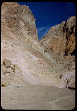
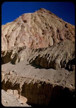
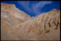
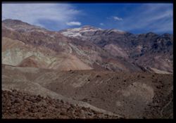
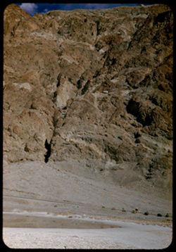
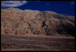
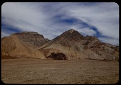
- Description:
- 25 f 13
- Subject:
- Rocks, Colored mountains, Valleys, Cliffs, Mountains, Rock formations, Death Valley (Calif. and Nev.), Deserts, and Hills
- Series:
- 15-52
- Creator:
- Cushman, Charles W., 1896-1972
- Date Created:
- 1952-04-09
- Genre:
- Landscape photographs
- Frame Number:
- 38
- Street Address:
- Artists Drive
- County:
- Inyo
- Abstract:
- From top of Artists Drive. Off Artists Drive.
- Call Number:
- P06057
- Country:
- United States
- State/Province:
- California
- Alternate Identifier:
- 1552.38
- Persistent URL:
- http://purl.dlib.indiana.edu/iudl/archives/cushman/P06057
-
- Description:
- 25 f 16
- Subject:
- Rocks, Valleys, Cliffs, Boulders, Mountains, Death Valley (Calif. and Nev.), and Deserts
- Series:
- 15-52
- Creator:
- Cushman, Charles W., 1896-1972
- Date Created:
- 1952-04-09
- Genre:
- Landscape photographs
- Frame Number:
- 37
- Street Address:
- Artists Drive
- County:
- Inyo
- Abstract:
- From top of Artists Drive. Up from Artists Dr.
- Call Number:
- P06056
- Country:
- United States
- State/Province:
- California
- Alternate Identifier:
- 1552.37
- Persistent URL:
- http://purl.dlib.indiana.edu/iudl/archives/cushman/P06056
-
- Description:
- 25 f 16
- Subject:
- Deserts, Valleys, Cliffs, Mountains, Rock formations, and Death Valley (Calif. and Nev.)
- Series:
- 15-52
- Creator:
- Cushman, Charles W., 1896-1972
- Date Created:
- 1952-04-09
- Genre:
- Snapshots
- Frame Number:
- 36
- Street Address:
- Artists Drive
- County:
- Inyo
- Abstract:
- From top of Artists Drive. Up from Artists Dr.
- Call Number:
- P06055
- Country:
- United States
- State/Province:
- California
- Alternate Identifier:
- 1552.36
- Persistent URL:
- http://purl.dlib.indiana.edu/iudl/archives/cushman/P06055
-
- Description:
- 25 f 8 Pola
- Subject:
- Deserts, Valleys, Hills, Death Valley (Calif. and Nev.), Mountains, Rocks, and Clouds
- Series:
- 15-52
- Creator:
- Cushman, Charles W., 1896-1972
- Date Created:
- 1952-04-09
- Genre:
- Landscape photographs
- Frame Number:
- 35
- Street Address:
- Artists Drive
- County:
- Inyo
- Abstract:
- From top of Artists Drive. Back across valley.
- Call Number:
- P06054
- Country:
- United States
- State/Province:
- California
- Alternate Identifier:
- 1552.35
- Persistent URL:
- http://purl.dlib.indiana.edu/iudl/archives/cushman/P06054
-
- Description:
- 25 f 16
- Subject:
- Deserts, Valleys, Cliffs, Mountains, Hills, and Death Valley (Calif. and Nev.)
- Series:
- 15-52
- Creator:
- Cushman, Charles W., 1896-1972
- Date Created:
- 1952-04-09
- Genre:
- Landscape photographs
- Frame Number:
- 34
- Street Address:
- Artists Drive
- County:
- Inyo
- Abstract:
- From top of Artists Drive. Up.
- Call Number:
- P06053
- Country:
- United States
- State/Province:
- California
- Physical Description:
- Image was originally mounted in a glass enclosure. Before digitization, the image was removed and placed in a Wess Plastic, Inc. brand, 2" x 2", pl...
- Alternate Identifier:
- 1552.34
- Persistent URL:
- http://purl.dlib.indiana.edu/iudl/archives/cushman/P06053
-
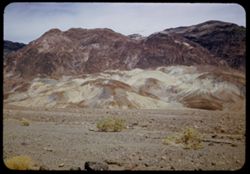
- Description:
- 25 f 13
- Subject:
- Rocks, Colored mountains, Valleys, Cliffs, Boulders, Mountains, Rock formations, Death Valley (Calif. and Nev.), Deserts, and Hills
- Series:
- 15-52
- Creator:
- Cushman, Charles W., 1896-1972
- Date Created:
- 1952-04-09
- Genre:
- Landscape photographs
- Frame Number:
- 33
- Street Address:
- Artists Drive
- County:
- Inyo
- Abstract:
- Colored mtns from Artists Drive.
- Call Number:
- P06052
- Country:
- United States
- State/Province:
- California
- Physical Description:
- Image was originally mounted in a glass enclosure. Before digitization, the image was removed and placed in a Wess Plastic, Inc. brand, 2" x 2", pl...
- Alternate Identifier:
- 1552.33
- Persistent URL:
- http://purl.dlib.indiana.edu/iudl/archives/cushman/P06052
-
- Description:
- 25 f 16
- Subject:
- Valleys, Rocks, Death Valley (Calif. and Nev.), Deserts, and Shrubs
- Series:
- 15-52
- Creator:
- Cushman, Charles W., 1896-1972
- Date Created:
- 1952-04-09
- Genre:
- Identification photographs
- Frame Number:
- 32
- County:
- Inyo
- Abstract:
- Desert holly.
- Call Number:
- P06051
- Country:
- United States
- State/Province:
- California
- Alternate Identifier:
- 1552.32
- Persistent URL:
- http://purl.dlib.indiana.edu/iudl/archives/cushman/P06051
-
- Description:
- 25 f 13
- Subject:
- Deserts, Valleys, Mountains, Hills, Rocks, and Death Valley (Calif. and Nev.)
- Series:
- 15-52
- Creator:
- Cushman, Charles W., 1896-1972
- Date Created:
- 1952-04-09
- Genre:
- Landscape photographs
- Frame Number:
- 31
- Street Address:
- Artists Drive
- County:
- Inyo
- Abstract:
- Mtns from Atrists Drive.
- Call Number:
- P06050
- Country:
- United States
- State/Province:
- California
- Physical Description:
- Image was originally mounted in a glass enclosure. Before digitization, the image was removed and placed in a Wess Plastic, Inc. brand, 2" x 2", pl...
- Alternate Identifier:
- 1552.31
- Persistent URL:
- http://purl.dlib.indiana.edu/iudl/archives/cushman/P06050
-
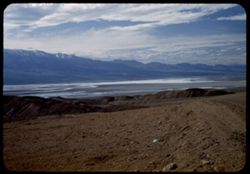
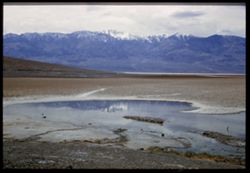
- Description:
- 25 f 9 Pola
- Subject:
- Lakes & ponds, Deserts, Valleys, Death Valley (Calif. and Nev.), Roads, Cliffs, Mountains, Boulders, and Rocks
- Series:
- 15-52
- Creator:
- Cushman, Charles W., 1896-1972
- Date Created:
- 1952-04-09
- Genre:
- Snapshots
- Frame Number:
- 29
- County:
- Inyo
- Abstract:
- Mtns at Bad Water, 279.6 ft. below
- Call Number:
- P06049
- City:
- Badwater
- Country:
- United States
- State/Province:
- California
- Alternate Identifier:
- 1552.29
- Persistent URL:
- http://purl.dlib.indiana.edu/iudl/archives/cushman/P06049
-
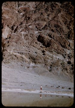
- Description:
- 25 f 13
- Subject:
- Lakes & ponds, Deserts, Reflections, Valleys, Death Valley (Calif. and Nev.), Roads, Cliffs, Mountains, Women, Boulders, and Rocks
- Series:
- 15-52
- Creator:
- Cushman, Charles W., 1896-1972
- Date Created:
- 1952-04-09
- Genre:
- Portraits and Snapshots
- Frame Number:
- 28
- County:
- Inyo
- Persons Pictured:
- Cushman, Jean
- Abstract:
- Mtns at Bad Water, 279.6 ft. below.
- Call Number:
- P06048
- City:
- Badwater
- Country:
- United States
- State/Province:
- California
- Alternate Identifier:
- 1552.28
- Persistent URL:
- http://purl.dlib.indiana.edu/iudl/archives/cushman/P06048
-
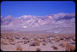
- Description:
- 25 f 11 Pola
- Subject:
- Deserts, Amargosa Range (Nev. and Calif.), Valleys, Death Valley (Calif. and Nev.), Mountains, and Rocks
- Series:
- 15-52
- Creator:
- Cushman, Charles W., 1896-1972
- Date Created:
- 1952-04-09
- Genre:
- Landscape photographs
- Frame Number:
- 27
- County:
- Inyo
- Abstract:
- Amargosa Mtns near Bad Water.
- Call Number:
- P06047
- City:
- Badwater
- Country:
- United States
- State/Province:
- California
- Physical Description:
- Image was originally mounted in a glass enclosure. Before digitization, the image was removed and placed in a Wess Plastic, Inc. brand, 2" x 2", pl...
- Alternate Identifier:
- 1552.27
- Persistent URL:
- http://purl.dlib.indiana.edu/iudl/archives/cushman/P06047
-
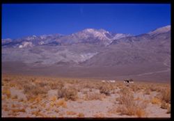
- Description:
- 25 f 8 Pola
- Subject:
- Bodies of water, Telescope Peak (Inyo County, Calif.), Hills, Mountains, Death Valley (Calif. and Nev.), Deserts, Shrubs, Valleys, and Snow
- Series:
- 15-52
- Creator:
- Cushman, Charles W., 1896-1972
- Date Created:
- 1952-04-09
- Genre:
- Landscape photographs
- Frame Number:
- 25
- County:
- Inyo
- Abstract:
- Telescope Pk. from Bad Water. 280 ft. below sea level.
- Call Number:
- P06045
- City:
- Badwater
- Country:
- United States
- State/Province:
- California
- Physical Description:
- Image was originally mounted in a glass enclosure. Before digitization, the image was removed and placed in a Wess Plastic, Inc. brand, 2" x 2", pl...
- Alternate Identifier:
- 1552.25
- Persistent URL:
- http://purl.dlib.indiana.edu/iudl/archives/cushman/P06045
-
- Description:
- 25 f 9 Pola
- Subject:
- Deserts, Valleys, Mountains, Death Valley (Calif. and Nev.), Amargosa Range (Nev. and Calif.), and Rocks
- Series:
- 15-52
- Creator:
- Cushman, Charles W., 1896-1972
- Date Created:
- 1952-04-09
- Genre:
- Landscape photographs
- Frame Number:
- 26
- County:
- Inyo
- Abstract:
- Amargosa Mtns near Bad Water.
- Call Number:
- P06046
- City:
- Badwater
- Country:
- United States
- State/Province:
- California
- Physical Description:
- Image was originally mounted in a glass enclosure. Before digitization, the image was removed and placed in a Wess Plastic, Inc. brand, 2" x 2", pl...
- Alternate Identifier:
- 1552.26
- Persistent URL:
- http://purl.dlib.indiana.edu/iudl/archives/cushman/P06046
-
- Description:
- 25 f 9 Pola
- Subject:
- Deserts, Valleys, Salt pools, Mountains, Shrubs, Hills, Black Mountains (Inyo County, Calif.), Rocks, and Death Valley (Calif. and Nev.)
- Series:
- 15-52
- Creator:
- Cushman, Charles W., 1896-1972
- Date Created:
- 1952-04-09
- Genre:
- Landscape photographs
- Frame Number:
- 24
- County:
- Inyo
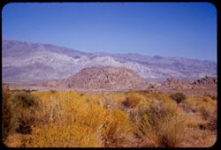
- Abstract:
- Colored Mtns. The Black Mtns - near Salt Pools this time.
- Call Number:
- P06044
- Country:
- United States
- State/Province:
- California
- Alternate Identifier:
- 1552.24
- Persistent URL:
- http://purl.dlib.indiana.edu/iudl/archives/cushman/P06044
-

- Description:
- 25 f 9 Pola
- Subject:
- Deserts, Valleys, Hills, Death Valley (Calif. and Nev.), Mountains, Colored mountains, Rocks, Rock formations, and Black Mountains (Inyo County, Calif.)
- Series:
- 15-52
- Creator:
- Cushman, Charles W., 1896-1972
- Date Created:
- 1952-04-09
- Genre:
- Landscape photographs
- Frame Number:
- 23
- County:
- Inyo
- Abstract:
- Colored Mtns. The Black Mtns.
- Call Number:
- P06043
- Country:
- United States
- State/Province:
- California
- Alternate Identifier:
- 1552.23
- Persistent URL:
- http://purl.dlib.indiana.edu/iudl/archives/cushman/P06043
-
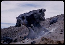
- Description:
- 25 f 10
- Subject:
- Deserts, Mushroom Rock (Inyo County, Calif.), Boulders, Rock formations, Hills, Rocks, Valleys, and Death Valley (Calif. and Nev.)
- Series:
- 15-52
- Creator:
- Cushman, Charles W., 1896-1972
- Date Created:
- 1952-04-09
- Genre:
- Snapshots
- Frame Number:
- 22
- County:
- Inyo
- Abstract:
- Mushroom rock.
- Call Number:
- P06042
- City:
- Furnace Creek
- Country:
- United States
- State/Province:
- California
- Alternate Identifier:
- 1552.22
- Persistent URL:
- http://purl.dlib.indiana.edu/iudl/archives/cushman/P06042
-

- Description:
- 25 f 14
- Subject:
- Deserts, Amargosa Range (Nev. and Calif.), Valleys, Hills, Death Valley (Calif. and Nev.), Cliffs, Mountains, Shrubs, Rocks, Canyons, and Desolation Canyon (...
- Series:
- 15-52
- Creator:
- Cushman, Charles W., 1896-1972
- Date Created:
- 1952-04-09
- Genre:
- Landscape photographs
- Frame Number:
- 21
- Street Address:
- Bad Water Road
- County:
- Inyo
- Abstract:
- Approx. same.
- Call Number:
- P06041
- City:
- Furnace Creek
- Country:
- United States
- State/Province:
- California
- Alternate Identifier:
- 1552.21
- Persistent URL:
- http://purl.dlib.indiana.edu/iudl/archives/cushman/P06041
-
- Description:
- 25 f 9 Pola
- Subject:
- Deserts, Valleys, Mountains, Death Valley (Calif. and Nev.), Canyons, Hills, and Desolation Canyon (Calif.)
- Series:
- 15-52
- Creator:
- Cushman, Charles W., 1896-1972
- Date Created:
- 1952-04-09
- Genre:
- Landscape photographs
- Frame Number:
- 20
- County:
- Inyo
- Abstract:
- From road to Bad Water toward Desolation Canyon.
- Call Number:
- P06040
- City:
- Furnace Creek and Badwater
- Country:
- United States
- State/Province:
- California
- Alternate Identifier:
- 1552.20
- Persistent URL:
- http://purl.dlib.indiana.edu/iudl/archives/cushman/P06040
-
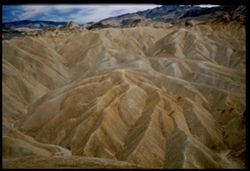
- Description:
- 25 f 11 Pola
- Subject:
- Deserts, Valleys, Mountains, Rock formations, Zabriskie Point (Calif.), and Death Valley (Calif. and Nev.)
- Series:
- 15-52
- Creator:
- Cushman, Charles W., 1896-1972
- Date Created:
- 1952-04-09
- Genre:
- Landscape photographs
- Frame Number:
- 19
- County:
- Inyo
- Abstract:
- East + down from Zab. Pt.
- Call Number:
- P06039
- City:
- Furnace Creek
- Country:
- United States
- State/Province:
- California
- Physical Description:
- Image was originally mounted in a glass enclosure. Before digitization, the image was removed and placed in a Wess Plastic, Inc. brand, 2" x 2", pl...
- Alternate Identifier:
- 1552.19
- Persistent URL:
- http://purl.dlib.indiana.edu/iudl/archives/cushman/P06039
-
- Description:
- 25 f 9 Pola
- Subject:
- Deserts, Valleys, Mountains, Rock formations, Zabriskie Point (Calif.), and Death Valley (Calif. and Nev.)
- Series:
- 15-52
- Creator:
- Cushman, Charles W., 1896-1972
- Date Created:
- 1952-04-09
- Genre:
- Landscape photographs
- Frame Number:
- 18
- County:
- Inyo
- Abstract:
- NW from out on shoulder.
- Call Number:
- P06038
- City:
- Furnace Creek
- Country:
- United States
- State/Province:
- California
- Alternate Identifier:
- 1552.18
- Persistent URL:
- http://purl.dlib.indiana.edu/iudl/archives/cushman/P06038
-
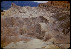
- Description:
- 25 f 8 Pola
- Subject:
- Deserts, Valleys, Cliffs, Mountains, Rock formations, Zabriskie Point (Calif.), and Death Valley (Calif. and Nev.)
- Series:
- 15-52
- Creator:
- Cushman, Charles W., 1896-1972
- Date Created:
- 1952-04-09
- Genre:
- Landscape photographs
- Frame Number:
- 17
- County:
- Inyo
- Abstract:
- West from north of Pt.
- Call Number:
- P06037
- City:
- Furnace Creek
- Country:
- United States
- State/Province:
- California
- Physical Description:
- Image was originally mounted in a glass enclosure. Before digitization, the image was removed and placed in a Wess Plastic, Inc. brand, 2" x 2", pl...
- Alternate Identifier:
- 1552.17
- Persistent URL:
- http://purl.dlib.indiana.edu/iudl/archives/cushman/P06037
-
- Description:
- 25 f 9 Pola
- Subject:
- Deserts, Valleys, Cliffs, Mountains, Zabriskie Point (Calif.), Death Valley (Calif. and Nev.), Streams, and Hills
- Series:
- 15-52
- Creator:
- Cushman, Charles W., 1896-1972
- Date Created:
- 1952-04-09
- Genre:
- Landscape photographs
- Frame Number:
- 16
- County:
- Inyo
- Abstract:
- West from Zabriskie Pt.
- Call Number:
- P06036
- City:
- Furnace Creek
- Country:
- United States
- State/Province:
- California
- Physical Description:
- Image was originally mounted in a glass enclosure. Before digitization, the image was removed and placed in a Wess Plastic, Inc. brand, 2" x 2", pl...
- Alternate Identifier:
- 1552.16
- Persistent URL:
- http://purl.dlib.indiana.edu/iudl/archives/cushman/P06036
-
- Description:
- 25 f 8 Pola
- Subject:
- Deserts, Valleys, Mountains, Shrubs, and Death Valley (Calif. and Nev.)
- Series:
- 15-52
- Creator:
- Cushman, Charles W., 1896-1972
- Date Created:
- 1952-04-09
- Genre:
- Landscape photographs
- Frame Number:
- 13
- County:
- Inyo
- Abstract:
- View WSW across valley.
- Call Number:
- P06034
- Country:
- United States
- State/Province:
- California
- Physical Description:
- Image was originally mounted in a glass enclosure. Before digitization, the image was removed and placed in a Wess Plastic, Inc. brand, 2" x 2", pl...
- Alternate Identifier:
- 1552.13
- Persistent URL:
- http://purl.dlib.indiana.edu/iudl/archives/cushman/P06034
-
- Description:
- 25 f 6.3 Pola
- Subject:
- Deserts, Valleys, Hills, Automobiles, Death Valley (Calif. and Nev.), Roads, Mountains, Shrubs, and Rocks
- Series:
- 15-52
- Creator:
- Cushman, Charles W., 1896-1972
- Date Created:
- 1952-04-09
- Genre:
- Landscape photographs
- Frame Number:
- 12
- County:
- Inyo
- Abstract:
- Death Valley from north.
- Call Number:
- P06033
- City:
- Beatty Junction
- Country:
- United States
- State/Province:
- California
- Alternate Identifier:
- 1552.12
- Persistent URL:
- http://purl.dlib.indiana.edu/iudl/archives/cushman/P06033
-
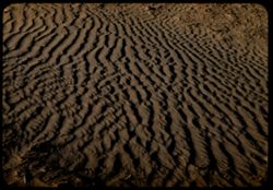
- Description:
- 25 f 8 Pola
- Subject:
- Deserts, Ripples, Valleys, Sand, Dunes, and Death Valley (Calif. and Nev.)
- Series:
- 15-52
- Creator:
- Cushman, Charles W., 1896-1972
- Date Created:
- 1952-04-08
- Genre:
- Snapshots
- Frame Number:
- 11
- County:
- Inyo
- Abstract:
- Sand ripples.
- Call Number:
- P06032
- City:
- Stovepipe Wells
- Country:
- United States
- State/Province:
- California
- Alternate Identifier:
- 1552.11
- Persistent URL:
- http://purl.dlib.indiana.edu/iudl/archives/cushman/P06032
-
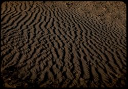
- Description:
- 25 f 8 Pola (with screen turned)
- Subject:
- Deserts, Ripples, Valleys, Sand, Dunes, and Death Valley (Calif. and Nev.)
- Series:
- 15-52
- Creator:
- Cushman, Charles W., 1896-1972
- Date Created:
- 1952-04-08
- Genre:
- Snapshots
- Frame Number:
- 10
- County:
- Inyo
- Abstract:
- Sand ripples.
- Call Number:
- P06031
- City:
- Stovepipe Wells
- Country:
- United States
- State/Province:
- California
- Alternate Identifier:
- 1552.10
- Persistent URL:
- http://purl.dlib.indiana.edu/iudl/archives/cushman/P06031
-
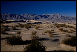
- Description:
- 25 f 8 Pola
- Subject:
- Deserts, Valleys, Sand, Dunes, Mountains, Shrubs, and Death Valley (Calif. and Nev.)
- Series:
- 15-52
- Creator:
- Cushman, Charles W., 1896-1972
- Date Created:
- 1952-04-01
- Genre:
- Landscape photographs
- Frame Number:
- 9
- County:
- Inyo
- Abstract:
- Sand Dunes near Stovepipe Wells.
- Call Number:
- P06030
- City:
- Stovepipe Wells
- Country:
- United States
- State/Province:
- California
- Physical Description:
- Image was originally mounted in a glass enclosure. Before digitization, the image was removed and placed in a Wess Plastic, Inc. brand, 2" x 2", pl...
- Alternate Identifier:
- 1552.9
- Persistent URL:
- http://purl.dlib.indiana.edu/iudl/archives/cushman/P06030
-
- Description:
- 25 f 8 Pola
- Subject:
- Deserts, Valleys, Roads, Mountains, Shrubs, Panamint Valley (Calif.), Hills, Rocks, Panamint Range (Calif.), and Death Valley (Calif. and Nev.)
- Series:
- 15-52
- Creator:
- Cushman, Charles W., 1896-1972
- Date Created:
- 1952-04-08
- Genre:
- Landscape photographs
- Frame Number:
- 6
- County:
- Inyo
- Abstract:
- Road is straight across Panamint Valley.
- Call Number:
- P06027
- Country:
- United States
- State/Province:
- California
- Physical Description:
- Image was originally mounted in a glass enclosure. Before digitization, the image was removed and placed in a Wess Plastic, Inc. brand, 2" x 2", pl...
- Alternate Identifier:
- 1552.6
- Persistent URL:
- http://purl.dlib.indiana.edu/iudl/archives/cushman/P06027
-
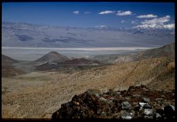
- Description:
- 25 f 9
- Subject:
- Panamint Mountains (Calif.), Deserts, Canyons, Valleys, Death Valley (Calif. and Nev.), Panamint Valley (Calif.), Mountains, Cliffs, and Panamint Range (Calif.)
- Series:
- 15-52
- Creator:
- Cushman, Charles W., 1896-1972
- Date Created:
- 1952-04-01
- Genre:
- Landscape photographs
- Frame Number:
- 3
- County:
- Inyo
- Abstract:
- Mouth of Canyon into Panamint Valley - Panamint Mtns in distance.
- Call Number:
- P06024
- Country:
- United States
- State/Province:
- California
- Physical Description:
- Image was originally mounted in a glass enclosure. Before digitization, the image was removed and placed in a Wess Plastic, Inc. brand, 2" x 2", pl...
- Alternate Identifier:
- 1552.3
- Persistent URL:
- http://purl.dlib.indiana.edu/iudl/archives/cushman/P06024
-
- Description:
- 25 f 8 Pola
- Subject:
- Deserts, Valleys, Panamint Range (Calif.), Panamint Mountains (Calif.), Argus Range (Calif.), Mountains, Shrubs, Panamint Valley (Calif.), Death Valley (Cali...
- Series:
- 15-52
- Creator:
- Cushman, Charles W., 1896-1972
- Date Created:
- 1952-04-08
- Genre:
- Landscape photographs
- Frame Number:
- 4
- County:
- Inyo
- Abstract:
- Same [P]
- Call Number:
- P06025
- Country:
- United States
- State/Province:
- California
- Alternate Identifier:
- 1552.4
- Persistent URL:
- http://purl.dlib.indiana.edu/iudl/archives/cushman/P06025
-
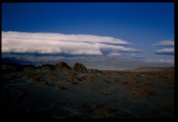
- Description:
- 25 f 9
- Subject:
- Panamint Mountains (Calif.), Deserts, Panamint Range (Calif.), Rocks, Rock formations, Mountains, and Clouds
- Series:
- 14-52
- Creator:
- Cushman, Charles W., 1896-1972
- Date Created:
- 1952-04-07
- Genre:
- Landscape photographs
- Frame Number:
- 14
- County:
- Inyo and San Bernardino
- Abstract:
- White cloud + distant Panamint Mtns. from few miles south of Trona.
- Call Number:
- P05998
- City:
- Trona
- Country:
- United States
- State/Province:
- California
- Physical Description:
- Image was originally mounted in a glass enclosure. Before digitization, the image was removed and placed in a Wess Plastic, Inc. brand, 2" x 2", pl...
- Alternate Identifier:
- 1452.14
- Persistent URL:
- http://purl.dlib.indiana.edu/iudl/archives/cushman/P05998