
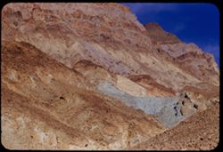
Search Constraints
You searched for:
Campus
IUB
Remove constraint Campus: IUB
County
Inyo
Remove constraint County: Inyo
Subject
Rocks
Remove constraint Subject: Rocks
« Previous |
1 - 100 of 132
|
Next »
Search Results
-
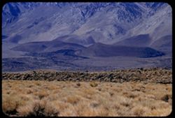
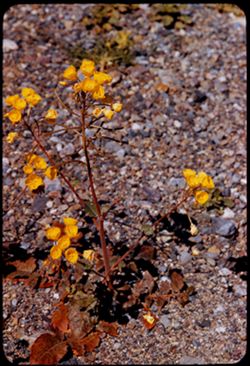
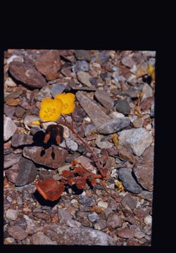
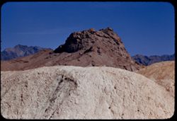
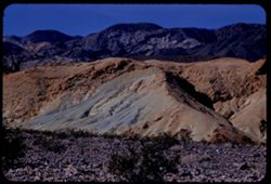
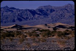
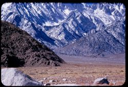
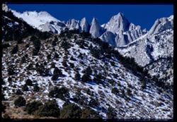
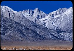
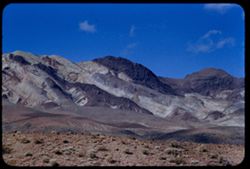
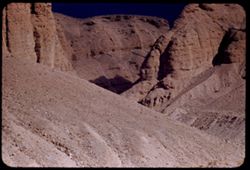
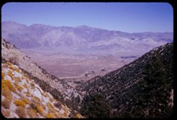
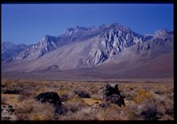
- Description:
- 100 f 6.3
- Subject:
- Rocks, Grasses, Mountains, Sierra Nevada (Calif. and Nev.), and Hills
- Series:
- 26-55
- Creator:
- Cushman, Charles W., 1896-1972
- Date Created:
- 1955-09-25
- Genre:
- Landscape photographs
- Frame Number:
- 3
- County:
- Inyo
- Abstract:
- Looking at base of range to SSW
- Call Number:
- P08386
- City:
- Big Pine and Independence
- Country:
- United States
- State/Province:
- California
- Alternate Identifier:
- 2655.3
- Persistent URL:
- http://purl.dlib.indiana.edu/iudl/archives/cushman/P08386
- Holding Location:
- Bloomington - University Archives
Wells Library E460
1320 E 10th St.
Bloomington, IN 47405
Contact at archives@indiana.edu, 812-855-1127
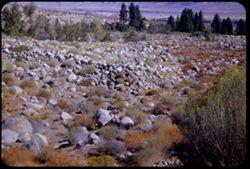
-
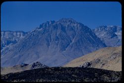
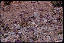
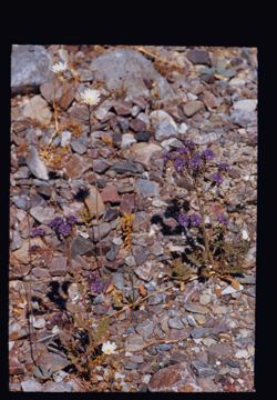
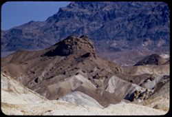
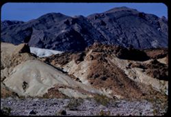
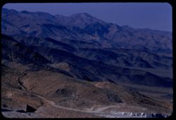
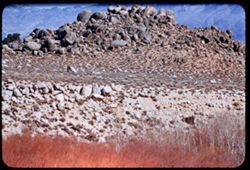
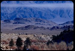
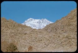
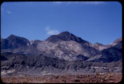
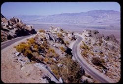
- Description:
- 100 f 6.3 TL
- Subject:
- Rocks, Owens Valley (Calif.), Mountains, Land, and Sierra Nevada (Calif. and Nev.)
- Series:
- 25-55
- Creator:
- Cushman, Charles W., 1896-1972
- Date Created:
- 1955-09-25
- Genre:
- Landscape photographs
- Frame Number:
- 33
- County:
- Inyo
- Abstract:
- Like a huge chocolate drop
- Call Number:
- P08378
- City:
- Big Pine
- Country:
- United States
- State/Province:
- California
- Alternate Identifier:
- 2555.33
- Persistent URL:
- http://purl.dlib.indiana.edu/iudl/archives/cushman/P08378
- Holding Location:
- Bloomington - University Archives
Wells Library E460
1320 E 10th St.
Bloomington, IN 47405
Contact at archives@indiana.edu, 812-855-1127
-
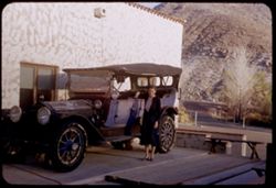
- Subject:
- Rocks, Benches, Roads, Spouses, Automobiles, Trees, Mountains, Shrubs, Scotty's Castle (Calif.), Death Valley (Calif. and Nev.), Castles & palaces, P...
- Series:
- 11-55
- Creator:
- Cushman, Charles W., 1896-1972
- Date Created:
- 1955-03-23
- Genre:
- Portraits and Identification photographs
- Frame Number:
- 37
- County:
- Inyo
- Persons Pictured:
- Cushman, Jean
- Abstract:
- Jean with old Packard touring car
- Call Number:
- P07896
- Country:
- United States
- State/Province:
- California
- Alternate Identifier:
- 1155.37
- Persistent URL:
- http://purl.dlib.indiana.edu/iudl/archives/cushman/P07896
- Holding Location:
- Bloomington - University Archives
Wells Library E460
1320 E 10th St.
Bloomington, IN 47405
Contact at archives@indiana.edu, 812-855-1127
-
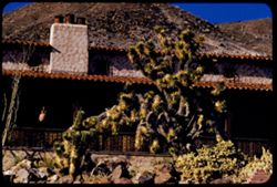
- Description:
- 100 f 8 tl
- Subject:
- Rocks, Joshua trees, Chimneys, Roofs, Shrubs, Masonry, Scotty's Castle (Calif.), Death Valley (Calif. and Nev.), Castles & palaces, and Hills
- Series:
- 11-55
- Creator:
- Cushman, Charles W., 1896-1972
- Date Created:
- 1955-03-23
- Genre:
- Identification photographs
- Frame Number:
- 33
- County:
- Inyo
- Abstract:
- Joshua Tree at cottage
- Call Number:
- P07892
- Country:
- United States
- State/Province:
- California
- Alternate Identifier:
- 1155.33
- Persistent URL:
- http://purl.dlib.indiana.edu/iudl/archives/cushman/P07892
- Holding Location:
- Bloomington - University Archives
Wells Library E460
1320 E 10th St.
Bloomington, IN 47405
Contact at archives@indiana.edu, 812-855-1127
-
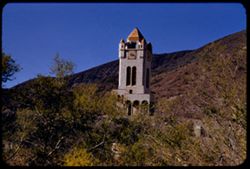
- Description:
- 100 f 8 tl
- Subject:
- Rocks, Bell towers, Trees, Arches, Mountains, Shrubs, Clock towers, Scotty's Castle (Calif.), Death Valley (Calif. and Nev.), Columns, Castles & pala...
- Series:
- 11-55
- Creator:
- Cushman, Charles W., 1896-1972
- Date Created:
- 1955-03-23
- Genre:
- Architectural photographs
- Frame Number:
- 28
- County:
- Inyo
- Abstract:
- Scotty's Tower from gate
- Call Number:
- P07887
- Country:
- United States
- State/Province:
- California
- Alternate Identifier:
- 1155.28
- Persistent URL:
- http://purl.dlib.indiana.edu/iudl/archives/cushman/P07887
- Holding Location:
- Bloomington - University Archives
Wells Library E460
1320 E 10th St.
Bloomington, IN 47405
Contact at archives@indiana.edu, 812-855-1127
-
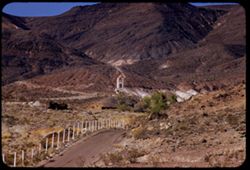
- Description:
- 100 f 8 tl
- Subject:
- Towers, Roads, Trees, Mountains, Buildings, Shrubs, Scotty's Castle (Calif.), Death Valley (Calif. and Nev.), Castles & palaces, and Rocks
- Series:
- 11-55
- Creator:
- Cushman, Charles W., 1896-1972
- Date Created:
- 1955-03-23
- Genre:
- Landscape photographs
- Frame Number:
- 27
- County:
- Inyo
- Abstract:
- First view of Scott's Tower
- Call Number:
- P07886
- Country:
- United States
- State/Province:
- California
- Alternate Identifier:
- 1155.27
- Persistent URL:
- http://purl.dlib.indiana.edu/iudl/archives/cushman/P07886
- Holding Location:
- Bloomington - University Archives
Wells Library E460
1320 E 10th St.
Bloomington, IN 47405
Contact at archives@indiana.edu, 812-855-1127
-
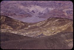
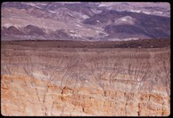
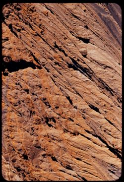
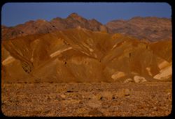
- Description:
- 100 f 8 tl
- Subject:
- Rocks, Valleys, Ubehebe Crater (Calif.), Shrubs, Death Valley (Calif. and Nev.), and Mountains
- Series:
- 11-55
- Creator:
- Cushman, Charles W., 1896-1972
- Date Created:
- 1955-03-23
- Genre:
- Landscape photographs
- Frame Number:
- 26
- County:
- Inyo
- Abstract:
- Ridges NE of crater long at right corrected
- Call Number:
- P07885
- Country:
- United States
- State/Province:
- California
- Alternate Identifier:
- 1155.26
- Persistent URL:
- http://purl.dlib.indiana.edu/iudl/archives/cushman/P07885
- Holding Location:
- Bloomington - University Archives
Wells Library E460
1320 E 10th St.
Bloomington, IN 47405
Contact at archives@indiana.edu, 812-855-1127
-
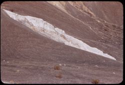
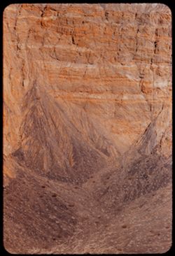
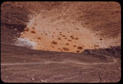
- Description:
- 100 f 6.3 tl
- Subject:
- Rocks, Craters, Mountains, Shrubs, Hills, Ubehebe Crater (Calif.), and Death Valley (Calif. and Nev.)
- Series:
- 11-55
- Creator:
- Cushman, Charles W., 1896-1972
- Date Created:
- 1955-03-23
- Frame Number:
- 25
- County:
- Inyo
- Abstract:
- Strange white ridge in bowl of Ubehebe Crater
- Call Number:
- P07884
- Country:
- United States
- State/Province:
- California
- Alternate Identifier:
- 1155.25
- Persistent URL:
- http://purl.dlib.indiana.edu/iudl/archives/cushman/P07884
- Holding Location:
- Bloomington - University Archives
Wells Library E460
1320 E 10th St.
Bloomington, IN 47405
Contact at archives@indiana.edu, 812-855-1127
-
- Description:
- 200 f 5.6 tl
- Subject:
- Rocks, Craters, Grapevine Mountains (Calif. and Nev.), Mountains, Shrubs, Death Valley (Calif. and Nev.), and Ubehebe Crater (Calif.)
- Series:
- 11-55
- Creator:
- Cushman, Charles W., 1896-1972
- Date Created:
- 1955-03-23
- Genre:
- Landscape photographs
- Frame Number:
- 23
- County:
- Inyo
- Abstract:
- Mtns above east rim Long at right
- Call Number:
- P07882
- Country:
- United States
- State/Province:
- California
- Alternate Identifier:
- 1155.23
- Persistent URL:
- http://purl.dlib.indiana.edu/iudl/archives/cushman/P07882
- Holding Location:
- Bloomington - University Archives
Wells Library E460
1320 E 10th St.
Bloomington, IN 47405
Contact at archives@indiana.edu, 812-855-1127
-
- Description:
- 100 f 8 tl
- Subject:
- Valleys, Death Valley (Calif. and Nev.), Craters, Shrubs, Rocks, and Ubehebe Crater (Calif.)
- Series:
- 11-55
- Creator:
- Cushman, Charles W., 1896-1972
- Date Created:
- 1955-03-23
- Genre:
- Landscape photographs
- Frame Number:
- 21
- County:
- Inyo
- Abstract:
- East wall
- Call Number:
- P07881
- Country:
- United States
- State/Province:
- California
- Alternate Identifier:
- 1155.21
- Persistent URL:
- http://purl.dlib.indiana.edu/iudl/archives/cushman/P07881
- Holding Location:
- Bloomington - University Archives
Wells Library E460
1320 E 10th St.
Bloomington, IN 47405
Contact at archives@indiana.edu, 812-855-1127
-
- Description:
- 100 f 8 tl
- Subject:
- Death Valley (Calif. and Nev.), Craters, Rocks, Ubehebe Crater (Calif.), and Rock formations
- Series:
- 11-55
- Creator:
- Cushman, Charles W., 1896-1972
- Date Created:
- 1955-03-23
- Genre:
- Landscape photographs
- Frame Number:
- 20
- County:
- Inyo
- Abstract:
- SE Wall
- Call Number:
- P07880
- Country:
- United States
- State/Province:
- California
- Alternate Identifier:
- 1155.20
- Persistent URL:
- http://purl.dlib.indiana.edu/iudl/archives/cushman/P07880
- Holding Location:
- Bloomington - University Archives
Wells Library E460
1320 E 10th St.
Bloomington, IN 47405
Contact at archives@indiana.edu, 812-855-1127
-
- Description:
- 100 f 8 tl
- Subject:
- Rocks, Craters, Ubehebe Crater (Calif.), Shrubs, and Death Valley (Calif. and Nev.)
- Series:
- 11-55
- Creator:
- Cushman, Charles W., 1896-1972
- Date Created:
- 1955-03-23
- Frame Number:
- 17
- County:
- Inyo
- Abstract:
- The bottom
- Call Number:
- P07878
- Country:
- United States
- State/Province:
- California
- Alternate Identifier:
- 1155.17
- Persistent URL:
- http://purl.dlib.indiana.edu/iudl/archives/cushman/P07878
- Holding Location:
- Bloomington - University Archives
Wells Library E460
1320 E 10th St.
Bloomington, IN 47405
Contact at archives@indiana.edu, 812-855-1127
-
- Description:
- 100 f 8 tl 6'
- Subject:
- Rocks, Death Valley (Calif. and Nev.), Primroses, Flowers, and Furnace Creek Wash (Calif.)
- Series:
- 11-55
- Creator:
- Cushman, Charles W., 1896-1972
- Date Created:
- 1955-03-23
- Genre:
- Identification photographs
- Frame Number:
- 13
- County:
- Inyo
- Abstract:
- Frost stemmed primrose Cut long at rt
- Call Number:
- P07875
- Country:
- United States
- State/Province:
- California
- Alternate Identifier:
- 1155.13
- Persistent URL:
- http://purl.dlib.indiana.edu/iudl/archives/cushman/P07875
- Holding Location:
- Bloomington - University Archives
Wells Library E460
1320 E 10th St.
Bloomington, IN 47405
Contact at archives@indiana.edu, 812-855-1127
-
- Description:
- 100 f 8 tl 9 ft
- Subject:
- Flowers, Death Valley (Calif. and Nev.), Mojavia, Phacelia, Furnace Creek Wash (Calif.), Primroses, and Rocks
- Series:
- 11-55
- Creator:
- Cushman, Charles W., 1896-1972
- Date Created:
- 1955-03-23
- Genre:
- Identification photographs
- Frame Number:
- 12
- County:
- Inyo
- Abstract:
- Group - located R of phacelia, primrose and Majavia (yellow)
- Call Number:
- P07874
- Country:
- United States
- State/Province:
- California
- Alternate Identifier:
- 1155.12
- Persistent URL:
- http://purl.dlib.indiana.edu/iudl/archives/cushman/P07874
- Holding Location:
- Bloomington - University Archives
Wells Library E460
1320 E 10th St.
Bloomington, IN 47405
Contact at archives@indiana.edu, 812-855-1127
-
- Description:
- 100 f 8 tl 35'
- Subject:
- Rocks, Furnace Creek Wash (Calif.), Teachers, Spouses, Women, Shrubs, and Death Valley (Calif. and Nev.)
- Series:
- 11-55
- Creator:
- Cushman, Charles W., 1896-1972
- Date Created:
- 1955-03-23
- Genre:
- Portraits and Identification photographs
- Frame Number:
- 11
- County:
- Inyo
- Persons Pictured:
- Cushman, Jean
- Abstract:
- Jean & teacher at Tamarisk
- Call Number:
- P07873
- Country:
- United States
- State/Province:
- California
- Alternate Identifier:
- 1155.11
- Persistent URL:
- http://purl.dlib.indiana.edu/iudl/archives/cushman/P07873
- Holding Location:
- Bloomington - University Archives
Wells Library E460
1320 E 10th St.
Bloomington, IN 47405
Contact at archives@indiana.edu, 812-855-1127
-
- Description:
- 100 f 8 tl 6 ft.
- Subject:
- Rocks, Phacelia, Furnace Creek Wash (Calif.), Flowers, and Death Valley (Calif. and Nev.)
- Series:
- 11-55
- Creator:
- Cushman, Charles W., 1896-1972
- Date Created:
- 1955-03-23
- Genre:
- Identification photographs
- Frame Number:
- 10
- County:
- Inyo
- Abstract:
- Phacelia (purple)
- Call Number:
- P07872
- Country:
- United States
- State/Province:
- California
- Alternate Identifier:
- 1155.10
- Persistent URL:
- http://purl.dlib.indiana.edu/iudl/archives/cushman/P07872
- Holding Location:
- Bloomington - University Archives
Wells Library E460
1320 E 10th St.
Bloomington, IN 47405
Contact at archives@indiana.edu, 812-855-1127
-
- Description:
- 100 f 8 + tl 8 ft.
- Subject:
- Rocks, Furnace Creek Wash (Calif.), Primroses, Flowers, Primrose, and Death Valley (Calif. and Nev.)
- Series:
- 11-55
- Creator:
- Cushman, Charles W., 1896-1972
- Date Created:
- 1955-03-23
- Genre:
- Identification photographs
- Frame Number:
- 9
- County:
- Inyo
- Abstract:
- Primrose (golden cups) in Wash.
- Call Number:
- P07871
- Country:
- United States
- State/Province:
- California
- Alternate Identifier:
- 1155.9
- Persistent URL:
- http://purl.dlib.indiana.edu/iudl/archives/cushman/P07871
- Holding Location:
- Bloomington - University Archives
Wells Library E460
1320 E 10th St.
Bloomington, IN 47405
Contact at archives@indiana.edu, 812-855-1127
-
- Description:
- 100 f 8 tl 20'
- Subject:
- Rocks, Flowers, and Death Valley (Calif. and Nev.)
- Series:
- 11-55
- Creator:
- Cushman, Charles W., 1896-1972
- Date Created:
- 1955-03-23
- Genre:
- Identification photographs
- Frame Number:
- 7
- County:
- Inyo
- Abstract:
- Purple flowers
- Call Number:
- P07869
- Country:
- United States
- State/Province:
- California
- Alternate Identifier:
- 1155.7
- Persistent URL:
- http://purl.dlib.indiana.edu/iudl/archives/cushman/P07869
- Holding Location:
- Bloomington - University Archives
Wells Library E460
1320 E 10th St.
Bloomington, IN 47405
Contact at archives@indiana.edu, 812-855-1127
-
- Description:
- 100 f 8 tl 5 ft.
- Subject:
- Rocks, Flowers, and Death Valley (Calif. and Nev.)
- Series:
- 11-55
- Creator:
- Cushman, Charles W., 1896-1972
- Date Created:
- 1955-03-23
- Genre:
- Identification photographs
- Frame Number:
- 6
- County:
- Inyo
- Abstract:
- Two little yellow flowers
- Call Number:
- P07868
- Country:
- United States
- State/Province:
- California
- Physical Description:
- masked.
- Alternate Identifier:
- 1155.6
- Persistent URL:
- http://purl.dlib.indiana.edu/iudl/archives/cushman/P07868
- Holding Location:
- Bloomington - University Archives
Wells Library E460
1320 E 10th St.
Bloomington, IN 47405
Contact at archives@indiana.edu, 812-855-1127
-
- Description:
- 100 f 8 tl 11 ft
- Subject:
- Flowers, Death Valley (Calif. and Nev.), and Rocks
- Series:
- 11-55
- Creator:
- Cushman, Charles W., 1896-1972
- Date Created:
- 1955-03-23
- Genre:
- Identification photographs
- Frame Number:
- 5
- County:
- Inyo
- Abstract:
- White & purple
- Call Number:
- P07867
- Country:
- United States
- State/Province:
- California
- Physical Description:
- masked.
- Alternate Identifier:
- 1155.5
- Persistent URL:
- http://purl.dlib.indiana.edu/iudl/archives/cushman/P07867
- Holding Location:
- Bloomington - University Archives
Wells Library E460
1320 E 10th St.
Bloomington, IN 47405
Contact at archives@indiana.edu, 812-855-1127
-
- Description:
- 100 f 8 tl 11 ft.
- Subject:
- Rocks, Shrubs, Death Valley (Calif. and Nev.), and Buckwheat
- Series:
- 11-55
- Creator:
- Cushman, Charles W., 1896-1972
- Date Created:
- 1955-03-23
- Genre:
- Identification photographs
- Frame Number:
- 4
- County:
- Inyo
- Abstract:
- Little bean stalk plant Buckwheat
- Call Number:
- P07866
- Country:
- United States
- State/Province:
- California
- Alternate Identifier:
- 1155.4
- Persistent URL:
- http://purl.dlib.indiana.edu/iudl/archives/cushman/P07866
- Holding Location:
- Bloomington - University Archives
Wells Library E460
1320 E 10th St.
Bloomington, IN 47405
Contact at archives@indiana.edu, 812-855-1127
-
- Description:
- 100 f 8 tl 6 ft.
- Subject:
- Rocks, Phacelia, Funeral Mountains (Calif.), Flowers, Furnace Creek Inn (Death Valley Junction, Calif.), and Death Valley (Calif. and Nev.)
- Series:
- 11-55
- Creator:
- Cushman, Charles W., 1896-1972
- Date Created:
- 1955-03-23
- Genre:
- Identification photographs
- Frame Number:
- 3
- Street Address:
- California State Highway 190
- County:
- Inyo
- Abstract:
- Purple flower (phacelia) along 190 east of Furnace Cr.
- Call Number:
- P07865
- City:
- Death Valley Junction
- Country:
- United States
- State/Province:
- California
- Alternate Identifier:
- 1155.3
- Persistent URL:
- http://purl.dlib.indiana.edu/iudl/archives/cushman/P07865
- Holding Location:
- Bloomington - University Archives
Wells Library E460
1320 E 10th St.
Bloomington, IN 47405
Contact at archives@indiana.edu, 812-855-1127
-
- Description:
- 100 f 8 + tl
- Subject:
- Rocks, Twenty Mule Team Canyon (Calif.), Canyons, Mountains, Rock formations, and Biscuit, The
- Series:
- 11-55
- Creator:
- Cushman, Charles W., 1896-1972
- Date Created:
- 1955-03-23
- Genre:
- Landscape photographs
- Frame Number:
- 2
- County:
- Inyo
- Abstract:
- The Biscuit seen from exit of 20 Mule T. canyon
- Call Number:
- P07864
- Country:
- United States
- State/Province:
- California
- Alternate Identifier:
- 1155.2
- Persistent URL:
- http://purl.dlib.indiana.edu/iudl/archives/cushman/P07864
- Holding Location:
- Bloomington - University Archives
Wells Library E460
1320 E 10th St.
Bloomington, IN 47405
Contact at archives@indiana.edu, 812-855-1127
-
- Description:
- 50 f 13 tl at 7 ft.
- Subject:
- Rocks, Twenty Mule Team Canyon (Calif.), Featherweight Rock, and Death Valley National Park (Calif. and Nev.)
- Series:
- 11-55
- Creator:
- Cushman, Charles W., 1896-1972
- Date Created:
- 1955-03-23
- Genre:
- Identification photographs
- Frame Number:
- 1
- County:
- Inyo
- Abstract:
- Close up ( 7 ft) of feather-weight rock
- Call Number:
- P07863
- Country:
- United States
- State/Province:
- California
- Alternate Identifier:
- 1155.1
- Persistent URL:
- http://purl.dlib.indiana.edu/iudl/archives/cushman/P07863
- Holding Location:
- Bloomington - University Archives
Wells Library E460
1320 E 10th St.
Bloomington, IN 47405
Contact at archives@indiana.edu, 812-855-1127
-
- Description:
- 100 F 8 tl
- Subject:
- Rocks, Twenty Mule Team Canyon (Calif.), Canyons, Mountains, Rock formations, and Death Valley National Park (Calif. and Nev.)
- Series:
- 10-55
- Creator:
- Cushman, Charles W., 1896-1972
- Date Created:
- 1955-03-23
- Genre:
- Landscape photographs
- Frame Number:
- 37
- County:
- Inyo
- Abstract:
- In 20 Mule Team canyon
- Call Number:
- P07861
- Country:
- United States
- State/Province:
- California
- Alternate Identifier:
- 1055.37
- Persistent URL:
- http://purl.dlib.indiana.edu/iudl/archives/cushman/P07861
- Holding Location:
- Bloomington - University Archives
Wells Library E460
1320 E 10th St.
Bloomington, IN 47405
Contact at archives@indiana.edu, 812-855-1127
-
- Description:
- 100 f 6.3 tl
- Subject:
- Rocks, Twenty Mule Team Canyon (Calif.), Canyons, Mountains, Rock formations, Death Valley National Park (Calif. and Nev.), and Valleys
- Series:
- 10-55
- Creator:
- Cushman, Charles W., 1896-1972
- Date Created:
- 1955-03-23
- Genre:
- Landscape photographs
- Frame Number:
- 34
- County:
- Inyo
- Abstract:
- Same canyon
- Call Number:
- P07859
- Country:
- United States
- State/Province:
- California
- Alternate Identifier:
- 1055.34
- Persistent URL:
- http://purl.dlib.indiana.edu/iudl/archives/cushman/P07859
- Holding Location:
- Bloomington - University Archives
Wells Library E460
1320 E 10th St.
Bloomington, IN 47405
Contact at archives@indiana.edu, 812-855-1127
-
- Description:
- 100 f 6.3 tl
- Subject:
- Rocks, Twenty Mule Team Canyon (Calif.), Valleys, Mountains, Death Valley National Park (Calif. and Nev.), and Canyons
- Series:
- 10-55
- Creator:
- Cushman, Charles W., 1896-1972
- Date Created:
- 1955-03-23
- Genre:
- Landscape photographs
- Frame Number:
- 33
- County:
- Inyo
- Abstract:
- Same canyon
- Call Number:
- P07858
- Country:
- United States
- State/Province:
- California
- Alternate Identifier:
- 1055.33
- Persistent URL:
- http://purl.dlib.indiana.edu/iudl/archives/cushman/P07858
- Holding Location:
- Bloomington - University Archives
Wells Library E460
1320 E 10th St.
Bloomington, IN 47405
Contact at archives@indiana.edu, 812-855-1127
-
- Description:
- 100 f 6.3 tl 35 ft
- Subject:
- Deserts, Death Valley National Park (Calif. and Nev.), Furnace Creek Wash (Calif.), Shrubs, and Rocks
- Series:
- 10-55
- Creator:
- Cushman, Charles W., 1896-1972
- Date Created:
- 1955-03-23
- Genre:
- Identification photographs
- Frame Number:
- 25
- County:
- Inyo
- Abstract:
- Desert bush
- Call Number:
- P07850
- Country:
- United States
- State/Province:
- California
- Alternate Identifier:
- 1055.25
- Persistent URL:
- http://purl.dlib.indiana.edu/iudl/archives/cushman/P07850
- Holding Location:
- Bloomington - University Archives
Wells Library E460
1320 E 10th St.
Bloomington, IN 47405
Contact at archives@indiana.edu, 812-855-1127
-
- Description:
- 100 f 8 tl
- Subject:
- Zabriskie Point (Calif.), Hills, Mountains, Shrubs, Furnace Creek Wash (Calif.), and Rocks
- Series:
- 10-55
- Creator:
- Cushman, Charles W., 1896-1972
- Date Created:
- 1955-03-23
- Genre:
- Landscape photographs
- Frame Number:
- 24
- County:
- Inyo
- Abstract:
- Toward Zabriskie from 8 mi SE of Furnace Creek
- Call Number:
- P07849
- Country:
- United States
- State/Province:
- California
- Alternate Identifier:
- 1055.24
- Persistent URL:
- http://purl.dlib.indiana.edu/iudl/archives/cushman/P07849
- Holding Location:
- Bloomington - University Archives
Wells Library E460
1320 E 10th St.
Bloomington, IN 47405
Contact at archives@indiana.edu, 812-855-1127
-
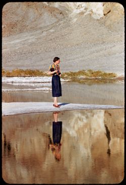
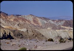
- Description:
- 100 f 5.6 tl
- Subject:
- Rocks, Valleys, Bodies of water, Spouses, Minerals, Salt, Shrubs, Death Valley (Calif. and Nev.), and Reflections
- Series:
- 10-55
- Creator:
- Cushman, Charles W., 1896-1972
- Date Created:
- 1955-03-22
- Genre:
- Portraits and Identification photographs
- Frame Number:
- 17
- County:
- Inyo
- Persons Pictured:
- Cushman, Jean
- Abstract:
- Jean at BW End of Mar. 22
- Call Number:
- P07842
- City:
- Badwater
- Country:
- United States
- State/Province:
- California
- Alternate Identifier:
- 1055.17
- Persistent URL:
- http://purl.dlib.indiana.edu/iudl/archives/cushman/P07842
- Holding Location:
- Bloomington - University Archives
Wells Library E460
1320 E 10th St.
Bloomington, IN 47405
Contact at archives@indiana.edu, 812-855-1127
-
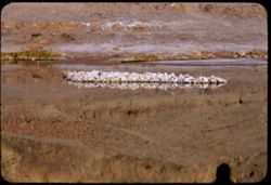
- Description:
- 100 f 6.3 tl
- Subject:
- Rocks, Bodies of water, Minerals, Salt, Shrubs, and Death Valley (Calif. and Nev.)
- Series:
- 10-55
- Creator:
- Cushman, Charles W., 1896-1972
- Date Created:
- 1955-03-22
- Frame Number:
- 16
- County:
- Inyo
- Abstract:
- Salt island at Bad Water
- Call Number:
- P07841
- City:
- Badwater
- Country:
- United States
- State/Province:
- California
- Alternate Identifier:
- 1055.16
- Persistent URL:
- http://purl.dlib.indiana.edu/iudl/archives/cushman/P07841
- Holding Location:
- Bloomington - University Archives
Wells Library E460
1320 E 10th St.
Bloomington, IN 47405
Contact at archives@indiana.edu, 812-855-1127
-
- Description:
- 100 f 9 tl
- Subject:
- Canyons, Mountains, Death Valley National Park (Calif. and Nev.), and Rocks
- Series:
- 10-55
- Creator:
- Cushman, Charles W., 1896-1972
- Date Created:
- 1955-03-22
- Genre:
- Landscape photographs
- Frame Number:
- 14
- Street Address:
- Artist's View Drive
- County:
- Inyo
- Abstract:
- Back up Artists Drive
- Call Number:
- P07839
- Country:
- United States
- State/Province:
- California
- Alternate Identifier:
- 1055.14
- Persistent URL:
- http://purl.dlib.indiana.edu/iudl/archives/cushman/P07839
- Holding Location:
- Bloomington - University Archives
Wells Library E460
1320 E 10th St.
Bloomington, IN 47405
Contact at archives@indiana.edu, 812-855-1127
-
- Description:
- 100 f 8 tl
- Subject:
- Valleys, Artists Palette (Calif.), Black Mountains (Inyo County, Calif.), Mountains, Death Valley National Park (Calif. and Nev.), Rocks, and Hills
- Series:
- 10-55
- Creator:
- Cushman, Charles W., 1896-1972
- Date Created:
- 1955-03-22
- Genre:
- Landscape photographs
- Frame Number:
- 12
- Street Address:
- Artist's View Drive
- County:
- Inyo
- Abstract:
- From observation pt of Artists Palette
- Call Number:
- P07837
- Country:
- United States
- State/Province:
- California
- Alternate Identifier:
- 1055.12
- Persistent URL:
- http://purl.dlib.indiana.edu/iudl/archives/cushman/P07837
- Holding Location:
- Bloomington - University Archives
Wells Library E460
1320 E 10th St.
Bloomington, IN 47405
Contact at archives@indiana.edu, 812-855-1127
-
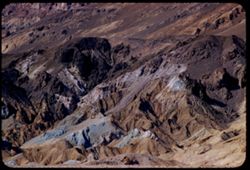
- Description:
- 100 f 6 tl
- Subject:
- Artists Palette (Calif.), Hills, Mountains, Death Valley National Park (Calif. and Nev.), and Rocks
- Series:
- 10-55
- Creator:
- Cushman, Charles W., 1896-1972
- Date Created:
- 1955-03-22
- Genre:
- Landscape photographs
- Frame Number:
- 4
- County:
- Inyo
- Abstract:
- The Artists palette
- Call Number:
- P07832
- Country:
- United States
- State/Province:
- California
- Alternate Identifier:
- 1055.4
- Persistent URL:
- http://purl.dlib.indiana.edu/iudl/archives/cushman/P07832
- Holding Location:
- Bloomington - University Archives
Wells Library E460
1320 E 10th St.
Bloomington, IN 47405
Contact at archives@indiana.edu, 812-855-1127
-
- Description:
- 100 f 8+ tl
- Subject:
- Rocks, Mountains, Clouds, and Death Valley National Park (Calif. and Nev.)
- Series:
- 10-55
- Creator:
- Cushman, Charles W., 1896-1972
- Date Created:
- 1955-03-22
- Frame Number:
- 2
- Street Address:
- Artist's View Drive
- County:
- Inyo
- Abstract:
- From top of Artists Drive
- Call Number:
- P07830
- Country:
- United States
- State/Province:
- California
- Alternate Identifier:
- 1055.2
- Persistent URL:
- http://purl.dlib.indiana.edu/iudl/archives/cushman/P07830
- Holding Location:
- Bloomington - University Archives
Wells Library E460
1320 E 10th St.
Bloomington, IN 47405
Contact at archives@indiana.edu, 812-855-1127
-
- Description:
- 100 f 8+ tl
- Subject:
- Rocks, Valleys, Mountains, and Death Valley National Park (Calif. and Nev.)
- Series:
- 10-55
- Creator:
- Cushman, Charles W., 1896-1972
- Date Created:
- 1955-03-22
- Frame Number:
- 1
- Street Address:
- Artist's View Drive
- County:
- Inyo
- Abstract:
- From top of Artists Drive
- Call Number:
- P07829
- Country:
- United States
- State/Province:
- California
- Alternate Identifier:
- 1055.1
- Persistent URL:
- http://purl.dlib.indiana.edu/iudl/archives/cushman/P07829
- Holding Location:
- Bloomington - University Archives
Wells Library E460
1320 E 10th St.
Bloomington, IN 47405
Contact at archives@indiana.edu, 812-855-1127
-
- Description:
- 100 f 8 tl
- Subject:
- Rocks, Valleys, Mountains, Death Valley National Park (Calif. and Nev.), and Black Mountains (Inyo County, Calif.)
- Series:
- 9-55
- Creator:
- Cushman, Charles W., 1896-1972
- Date Created:
- 1955-03-22
- Frame Number:
- 36
- Street Address:
- Artist's View Drive
- County:
- Inyo
- Abstract:
- Aboave Artists Drive [P]
- Call Number:
- P07826
- Country:
- United States
- State/Province:
- California
- Alternate Identifier:
- 955.36
- Persistent URL:
- http://purl.dlib.indiana.edu/iudl/archives/cushman/P07826
- Holding Location:
- Bloomington - University Archives
Wells Library E460
1320 E 10th St.
Bloomington, IN 47405
Contact at archives@indiana.edu, 812-855-1127
-
- Description:
- 100 f 8 tl
- Subject:
- Hills, Mountains, Death Valley National Park (Calif. and Nev.), Rocks, and Black Mountains (Inyo County, Calif.)
- Series:
- 9-55
- Creator:
- Cushman, Charles W., 1896-1972
- Date Created:
- 1955-03-22
- Frame Number:
- 35
- Street Address:
- Artist's View Drive
- County:
- Inyo
- Abstract:
- Above Artists Drive [P]
- Call Number:
- P07825
- Country:
- United States
- State/Province:
- California
- Alternate Identifier:
- 955.35
- Persistent URL:
- http://purl.dlib.indiana.edu/iudl/archives/cushman/P07825
- Holding Location:
- Bloomington - University Archives
Wells Library E460
1320 E 10th St.
Bloomington, IN 47405
Contact at archives@indiana.edu, 812-855-1127
-
- Description:
- 100 f 8 tl
- Subject:
- Furnace Creek Inn (Death Valley Junction, Calif.), Death Valley (Calif. and Nev.), Shrubs, Rocks, and Mesquite
- Series:
- 9-55
- Creator:
- Cushman, Charles W., 1896-1972
- Date Created:
- 1955-03-22
- Genre:
- Identification photographs
- Frame Number:
- 24
- County:
- Inyo
- Abstract:
- Mesquite nr. Furnace Creek Inn
- Call Number:
- P07815
- City:
- Death Valley Junction
- Country:
- United States
- State/Province:
- California
- Physical Description:
- masked.
- Alternate Identifier:
- 955.24
- Persistent URL:
- http://purl.dlib.indiana.edu/iudl/archives/cushman/P07815
- Holding Location:
- Bloomington - University Archives
Wells Library E460
1320 E 10th St.
Bloomington, IN 47405
Contact at archives@indiana.edu, 812-855-1127
-
- Description:
- 100 f 8 tl 12 ft.
- Subject:
- Rocks, Holly, Furnace Creek Wash (Calif.), and Deserts
- Series:
- 9-55
- Creator:
- Cushman, Charles W., 1896-1972
- Date Created:
- 1955-03-22
- Genre:
- Identification photographs
- Frame Number:
- 14
- County:
- Inyo
- Abstract:
- Desert holly blooming
- Call Number:
- P07806
- Country:
- United States
- State/Province:
- California
- Physical Description:
- masked.
- Alternate Identifier:
- 955.14
- Persistent URL:
- http://purl.dlib.indiana.edu/iudl/archives/cushman/P07806
- Holding Location:
- Bloomington - University Archives
Wells Library E460
1320 E 10th St.
Bloomington, IN 47405
Contact at archives@indiana.edu, 812-855-1127
-
- Description:
- 100 f 8 tl
- Subject:
- Rocks, Valleys, Trails & paths, Mountains, Lara Stream, Zabriskie Point (Calif.), and Death Valley National Park (Calif. and Nev.)
- Series:
- 9-55
- Creator:
- Cushman, Charles W., 1896-1972
- Date Created:
- 1955-03-22
- Genre:
- Landscape photographs
- Frame Number:
- 8
- County:
- Inyo
- Abstract:
- natural road way below Zabriskie Pt
- Call Number:
- P07800
- Country:
- United States
- State/Province:
- California
- Alternate Identifier:
- 955.8
- Persistent URL:
- http://purl.dlib.indiana.edu/iudl/archives/cushman/P07800
- Holding Location:
- Bloomington - University Archives
Wells Library E460
1320 E 10th St.
Bloomington, IN 47405
Contact at archives@indiana.edu, 812-855-1127
-
- Description:
- 100 f 8 tl
- Subject:
- Rocks, Valleys, Mountains, Shrubs, Zabriskie Point (Calif.), Death Valley National Park (Calif. and Nev.), and Hills
- Series:
- 9-55
- Creator:
- Cushman, Charles W., 1896-1972
- Date Created:
- 1955-03-22
- Genre:
- Landscape photographs
- Frame Number:
- 5
- County:
- Inyo
- Abstract:
- Yellow fan-shaped rock vicinity of Zabriskie Pt.
- Call Number:
- P07797
- Country:
- United States
- State/Province:
- California
- Alternate Identifier:
- 955.5
- Persistent URL:
- http://purl.dlib.indiana.edu/iudl/archives/cushman/P07797
- Holding Location:
- Bloomington - University Archives
Wells Library E460
1320 E 10th St.
Bloomington, IN 47405
Contact at archives@indiana.edu, 812-855-1127
-
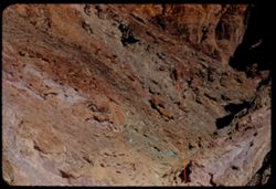
- Description:
- 100 f 6.3 tl
- Subject:
- Rocks, Dantes View (Calif.), Mountains, Rock formations, Death Valley (Calif. and Nev.), and Black Mountains (Inyo County, Calif.)
- Series:
- 8-55
- Creator:
- Cushman, Charles W., 1896-1972
- Date Created:
- 1955-03-22
- Genre:
- Landscape photographs
- Frame Number:
- 30
- County:
- Inyo
- Abstract:
- Down mtn rocks
- Call Number:
- P07786
- Country:
- United States
- State/Province:
- California
- Alternate Identifier:
- 855.30
- Persistent URL:
- http://purl.dlib.indiana.edu/iudl/archives/cushman/P07786
- Holding Location:
- Bloomington - University Archives
Wells Library E460
1320 E 10th St.
Bloomington, IN 47405
Contact at archives@indiana.edu, 812-855-1127
-
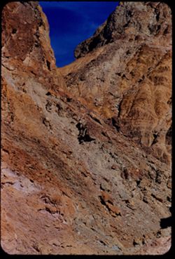
- Description:
- 100 f 8 tl
- Subject:
- Rocks, Roads, Dantes View (Calif.), Mountains, and Black Mountains (Inyo County, Calif.)
- Series:
- 8-55
- Creator:
- Cushman, Charles W., 1896-1972
- Date Created:
- 1955-03-22
- Genre:
- Landscape photographs
- Frame Number:
- 25
- County:
- Inyo
- Abstract:
- Marbled ridge down to NW
- Call Number:
- P07783
- Country:
- United States
- State/Province:
- California
- Alternate Identifier:
- 855.25
- Persistent URL:
- http://purl.dlib.indiana.edu/iudl/archives/cushman/P07783
- Holding Location:
- Bloomington - University Archives
Wells Library E460
1320 E 10th St.
Bloomington, IN 47405
Contact at archives@indiana.edu, 812-855-1127
-
- Description:
- 100 f 8 tl
- Subject:
- Rocks, Valleys, Mountains, Shrubs, Death Valley (Calif. and Nev.), Black Mountains (Inyo County, Calif.), and Hills
- Series:
- 8-55
- Creator:
- Cushman, Charles W., 1896-1972
- Date Created:
- 1955-03-22
- Genre:
- Landscape photographs
- Frame Number:
- 22
- Street Address:
- Dante's View Road
- County:
- Inyo
- Abstract:
- colored rock in valley from closer (along Dante's V. rd.
- Call Number:
- P07780
- Country:
- United States
- State/Province:
- California
- Alternate Identifier:
- 855.22
- Persistent URL:
- http://purl.dlib.indiana.edu/iudl/archives/cushman/P07780
- Holding Location:
- Bloomington - University Archives
Wells Library E460
1320 E 10th St.
Bloomington, IN 47405
Contact at archives@indiana.edu, 812-855-1127
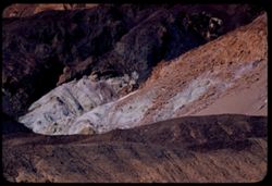
-
- Description:
- 100 f 6.3 tl
- Subject:
- Rocks, Mountains, Death Valley (Calif. and Nev.), and Black Mountains (Inyo County, Calif.)
- Series:
- 8-55
- Creator:
- Cushman, Charles W., 1896-1972
- Date Created:
- 1955-03-22
- Genre:
- Landscape photographs
- Frame Number:
- 21
- Street Address:
- Dante's View Road
- County:
- Inyo
- Abstract:
- colored rock in valley from closer (along Dante's V. rd.
- Call Number:
- P07779
- Country:
- United States
- State/Province:
- California
- Alternate Identifier:
- 855.21
- Persistent URL:
- http://purl.dlib.indiana.edu/iudl/archives/cushman/P07779
- Holding Location:
- Bloomington - University Archives
Wells Library E460
1320 E 10th St.
Bloomington, IN 47405
Contact at archives@indiana.edu, 812-855-1127
-
- Description:
- 100 f 5.6 tl
- Subject:
- Rocks, Valleys, Funeral Mountains (Calif.), Mountains, Shrubs, Death Valley (Calif. and Nev.), and Furnace Creek Inn (Death Valley Junction, Calif.)
- Series:
- 8-55
- Creator:
- Cushman, Charles W., 1896-1972
- Date Created:
- 1955-03-21
- Genre:
- Landscape photographs
- Frame Number:
- 14
- County:
- Inyo
- Abstract:
- Funeral mtns just north of Furnace CR Inn
- Call Number:
- P07772
- City:
- Death Valley Junction
- Country:
- United States
- State/Province:
- California
- Alternate Identifier:
- 855.14
- Persistent URL:
- http://purl.dlib.indiana.edu/iudl/archives/cushman/P07772
- Holding Location:
- Bloomington - University Archives
Wells Library E460
1320 E 10th St.
Bloomington, IN 47405
Contact at archives@indiana.edu, 812-855-1127
-
- Description:
- 100 f 6.3 tl
- Subject:
- Rocks, Valleys, Grapevine Mountains (Calif. and Nev.), Dunes, Mountains, Shrubs, and Death Valley (Calif. and Nev.)
- Series:
- 8-55
- Creator:
- Cushman, Charles W., 1896-1972
- Date Created:
- 1955-03-21
- Genre:
- Landscape photographs
- Frame Number:
- 6
- County:
- Inyo
- Abstract:
- S Sand dunes and Grapevine Mtns. north of road a mile or 2 e. of S.P.W. SD
- Call Number:
- P07766
- City:
- Stovepipe Wells
- Country:
- United States
- State/Province:
- California
- Physical Description:
- Image was originally mounted in a glass enclosure. Before digitization, the image was removed and placed in a Wess Plastic, Inc. brand, 2" x 2", pl...
- Alternate Identifier:
- 855.6
- Persistent URL:
- http://purl.dlib.indiana.edu/iudl/archives/cushman/P07766
- Holding Location:
- Bloomington - University Archives
Wells Library E460
1320 E 10th St.
Bloomington, IN 47405
Contact at archives@indiana.edu, 812-855-1127
-
- Description:
- 100 f 8 tl
- Subject:
- Valleys, Hills, Grapevine Mountains (Calif. and Nev.), Death Valley (Calif. and Nev.), Mountains, Shrubs, Rocks, and Dunes
- Series:
- 8-55
- Creator:
- Cushman, Charles W., 1896-1972
- Date Created:
- 1955-03-21
- Genre:
- Landscape photographs
- Frame Number:
- 5
- County:
- Inyo
- Abstract:
- S Sand dunes and Grapevine Mtns. north of road a mile or 2 e. of S.P.W. SD
- Call Number:
- P07765
- City:
- Stovepipe Wells
- Country:
- United States
- State/Province:
- California
- Alternate Identifier:
- 855.5
- Persistent URL:
- http://purl.dlib.indiana.edu/iudl/archives/cushman/P07765
- Holding Location:
- Bloomington - University Archives
Wells Library E460
1320 E 10th St.
Bloomington, IN 47405
Contact at archives@indiana.edu, 812-855-1127
-
- Description:
- 100 f 8 tl
- Subject:
- Rocks, Valleys, Roads, Argus Range (Calif.), Emigrant Pass (Inyo County, Calif.), Mountains, Shrubs, and Panamint Valley (Calif.)
- Series:
- 7-55
- Creator:
- Cushman, Charles W., 1896-1972
- Date Created:
- 1955-03-21
- Genre:
- Landscape photographs
- Frame Number:
- 34
- County:
- Inyo
- Abstract:
- NW along Argus mtns at west side of Panamint Valley from Emigrant pass.
- Call Number:
- P07758
- Country:
- United States
- State/Province:
- California
- Alternate Identifier:
- 755.34
- Persistent URL:
- http://purl.dlib.indiana.edu/iudl/archives/cushman/P07758
- Holding Location:
- Bloomington - University Archives
Wells Library E460
1320 E 10th St.
Bloomington, IN 47405
Contact at archives@indiana.edu, 812-855-1127
-
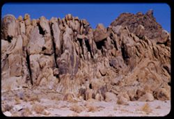
- Description:
- 100 f 8 tl
- Subject:
- Rocks, Boulders, Shrubs, Hills, Alabama Hills (Calif.), and Rock formations
- Series:
- 4-55
- Creator:
- Cushman, Charles W., 1896-1972
- Date Created:
- 1955-02-28
- Genre:
- Landscape photographs
- Frame Number:
- 9
- County:
- Inyo
- Abstract:
- Another odd formation in Alabama Hills
- Call Number:
- P07637
- City:
- Lone Pine
- Country:
- United States
- State/Province:
- California
- Alternate Identifier:
- 455.9
- Persistent URL:
- http://purl.dlib.indiana.edu/iudl/archives/cushman/P07637
- Holding Location:
- Bloomington - University Archives
Wells Library E460
1320 E 10th St.
Bloomington, IN 47405
Contact at archives@indiana.edu, 812-855-1127
-
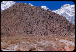
- Description:
- 100 f 8 tl
- Subject:
- Hills, Mountains, Shrubs, Snow, Boulders, Rocks, Fences, Sierra Nevada (Calif. and Nev.), and Alabama Hills (Calif.)
- Series:
- 4-55
- Creator:
- Cushman, Charles W., 1896-1972
- Date Created:
- 1955-02-28
- Genre:
- Landscape photographs
- Frame Number:
- 5
- County:
- Inyo
- Abstract:
- Ala Hills & back of roof of Sierra
- Call Number:
- P07633
- Country:
- United States
- State/Province:
- California
- Alternate Identifier:
- 455.5
- Persistent URL:
- http://purl.dlib.indiana.edu/iudl/archives/cushman/P07633
- Holding Location:
- Bloomington - University Archives
Wells Library E460
1320 E 10th St.
Bloomington, IN 47405
Contact at archives@indiana.edu, 812-855-1127
-
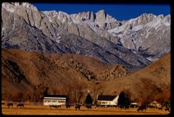
- Description:
- 100 f 5.6
- Subject:
- Snow, Valleys, Trees, Lone Pine Peak (Calif.), Mountains, Shrubs, Sierra Nevada (Calif. and Nev.), Hills, and Rocks
- Series:
- 4-55
- Creator:
- Cushman, Charles W., 1896-1972
- Date Created:
- 1955-02-28
- Genre:
- Landscape photographs
- Frame Number:
- 6
- County:
- Inyo
- Abstract:
- Sierra south of Lone Pine Pk
- Call Number:
- P07634
- Country:
- United States
- State/Province:
- California
- Alternate Identifier:
- 455.6
- Persistent URL:
- http://purl.dlib.indiana.edu/iudl/archives/cushman/P07634
- Holding Location:
- Bloomington - University Archives
Wells Library E460
1320 E 10th St.
Bloomington, IN 47405
Contact at archives@indiana.edu, 812-855-1127
-
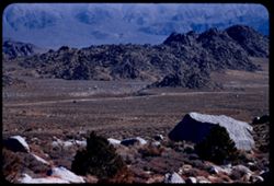
- Description:
- 100 f 5.6 tl
- Subject:
- Hills, Mounds (Landforms), Mountains, Shrubs, Trees, Alabama Hills (Calif.), Boulders, and Rocks
- Series:
- 4-55
- Creator:
- Cushman, Charles W., 1896-1972
- Date Created:
- 1955-02-28
- Genre:
- Landscape photographs
- Frame Number:
- 2
- County:
- Inyo
- Abstract:
- Mound of boulders = Alabama Hills
- Call Number:
- P07631
- City:
- Lone Pine
- Country:
- United States
- State/Province:
- California
- Alternate Identifier:
- 455.2
- Persistent URL:
- http://purl.dlib.indiana.edu/iudl/archives/cushman/P07631
- Holding Location:
- Bloomington - University Archives
Wells Library E460
1320 E 10th St.
Bloomington, IN 47405
Contact at archives@indiana.edu, 812-855-1127
-
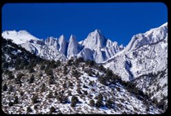
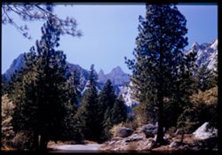
- Description:
- 100 f 9 tl
- Subject:
- Valleys, Whitney, Mount (Calif.), Mountains, Shrubs, Snow, Trees, Rocks, and Rock formations
- Series:
- 3-55
- Creator:
- Cushman, Charles W., 1896-1972
- Date Created:
- 1955-02-28
- Genre:
- Landscape photographs
- Frame Number:
- 38
- County:
- Inyo
- Abstract:
- Mt. Whitney
- Call Number:
- P07629
- Country:
- United States
- State/Province:
- California
- Alternate Identifier:
- 355.38
- Persistent URL:
- http://purl.dlib.indiana.edu/iudl/archives/cushman/P07629
- Holding Location:
- Bloomington - University Archives
Wells Library E460
1320 E 10th St.
Bloomington, IN 47405
Contact at archives@indiana.edu, 812-855-1127
-
- Description:
- 100 f 6.3 tl
- Subject:
- Rocks, Roads, Trails & paths, Mountains, Shrubs, Alabama Hills (Calif.), and Rock formations
- Series:
- 4-55
- Creator:
- Cushman, Charles W., 1896-1972
- Date Created:
- 1955-02-28
- Genre:
- Landscape photographs
- Frame Number:
- 1
- Street Address:
- Mount Whitney Road
- County:
- Inyo
- Abstract:
- Alabama Hills from Mt Whitney road
- Call Number:
- P07630
- Country:
- United States
- State/Province:
- California
- Alternate Identifier:
- 455.1
- Persistent URL:
- http://purl.dlib.indiana.edu/iudl/archives/cushman/P07630
- Holding Location:
- Bloomington - University Archives
Wells Library E460
1320 E 10th St.
Bloomington, IN 47405
Contact at archives@indiana.edu, 812-855-1127
-
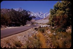
- Description:
- 100 f 8 tl
- Subject:
- Valleys, Whitney, Mount (Calif.), Mountains, Shrubs, Snow, Trees, Rocks, and Rock formations
- Series:
- 3-55
- Creator:
- Cushman, Charles W., 1896-1972
- Date Created:
- 1955-02-28
- Genre:
- Landscape photographs
- Frame Number:
- 37
- Street Address:
- Portal Road
- County:
- Inyo
- Abstract:
- Mt. Whitney
- Call Number:
- P07628
- Country:
- United States
- State/Province:
- California
- Physical Description:
- Image was originally mounted in a glass enclosure. Before digitization, the image was removed and placed in a Wess Plastic, Inc. brand, 2" x 2", pl...
- Alternate Identifier:
- 355.37
- Persistent URL:
- http://purl.dlib.indiana.edu/iudl/archives/cushman/P07628
- Holding Location:
- Bloomington - University Archives
Wells Library E460
1320 E 10th St.
Bloomington, IN 47405
Contact at archives@indiana.edu, 812-855-1127
-
- Description:
- 100 f 6.3 tl
- Subject:
- Owens Valley (Calif.), Mountains, Shrubs, Trees, Rocks, and Valleys
- Series:
- 3-55
- Creator:
- Cushman, Charles W., 1896-1972
- Date Created:
- 1955-02-28
- Genre:
- Landscape photographs
- Frame Number:
- 36
- Street Address:
- Mount Whitney Road
- County:
- Inyo
- Abstract:
- East across Owens Valley from Mt. Whitney rd.
- Call Number:
- P07627
- Country:
- United States
- State/Province:
- California
- Alternate Identifier:
- 355.36
- Persistent URL:
- http://purl.dlib.indiana.edu/iudl/archives/cushman/P07627
- Holding Location:
- Bloomington - University Archives
Wells Library E460
1320 E 10th St.
Bloomington, IN 47405
Contact at archives@indiana.edu, 812-855-1127
-
- Description:
- 100 f 5.6 tl
- Subject:
- Snow, Valleys, Trees, Lone Pine Peak (Calif.), Mountains, Shrubs, and Rocks
- Series:
- 3-55
- Creator:
- Cushman, Charles W., 1896-1972
- Date Created:
- 1955-02-28
- Genre:
- Landscape photographs
- Frame Number:
- 35
- Street Address:
- Mount Whitney Road
- County:
- Inyo
- Abstract:
- top of Lone Pine Pk
- Call Number:
- P07626
- City:
- Lone Pine
- Country:
- United States
- State/Province:
- California
- Alternate Identifier:
- 355.35
- Persistent URL:
- http://purl.dlib.indiana.edu/iudl/archives/cushman/P07626
- Holding Location:
- Bloomington - University Archives
Wells Library E460
1320 E 10th St.
Bloomington, IN 47405
Contact at archives@indiana.edu, 812-855-1127
-
- Description:
- 100 f 6.3 tl
- Subject:
- Valleys, Mountains, Shrubs, Snow, Trees, and Rocks
- Series:
- 3-55
- Creator:
- Cushman, Charles W., 1896-1972
- Date Created:
- 1955-02-28
- Genre:
- Landscape photographs
- Frame Number:
- 33
- Street Address:
- Mount Whitney Road and Whitney Portal Road
- County:
- Inyo
- Abstract:
- view of Whitney Road from 9 mi. up the Whitney Portal rd.
- Call Number:
- P07624
- City:
- Lone Pine
- Country:
- United States
- State/Province:
- California
- Alternate Identifier:
- 355.33
- Persistent URL:
- http://purl.dlib.indiana.edu/iudl/archives/cushman/P07624
- Holding Location:
- Bloomington - University Archives
Wells Library E460
1320 E 10th St.
Bloomington, IN 47405
Contact at archives@indiana.edu, 812-855-1127
-
- Description:
- 100 f 8 tl
- Subject:
- Rocks, Canyons, Mountains, Rock formations, Whitney, Mount (Calif.), Snow, and Shrubs
- Series:
- 3-55
- Creator:
- Cushman, Charles W., 1896-1972
- Date Created:
- 1955-02-28
- Genre:
- Landscape photographs
- Frame Number:
- 31
- County:
- Inyo
- Abstract:
- Whitney
- Call Number:
- P07622
- Country:
- United States
- State/Province:
- California
- Alternate Identifier:
- 355.31
- Persistent URL:
- http://purl.dlib.indiana.edu/iudl/archives/cushman/P07622
- Holding Location:
- Bloomington - University Archives
Wells Library E460
1320 E 10th St.
Bloomington, IN 47405
Contact at archives@indiana.edu, 812-855-1127
-
- Description:
- 100 f 8 tl
- Subject:
- Rocks, Mountains, Williamson, Mount (Inyo County, Calif.), Alabama Hills (Calif.), Hills, Snow, and Shrubs
- Series:
- 3-55
- Creator:
- Cushman, Charles W., 1896-1972
- Date Created:
- 1955-02-28
- Genre:
- Landscape photographs
- Frame Number:
- 30
- County:
- Inyo
- Abstract:
- High Mtn north of Whitney (Mt. Williamson) seen through gap in Alabama Hills
- Call Number:
- P07621
- City:
- Lone Pine
- Country:
- United States
- State/Province:
- California
- Alternate Identifier:
- 355.30
- Persistent URL:
- http://purl.dlib.indiana.edu/iudl/archives/cushman/P07621
- Holding Location:
- Bloomington - University Archives
Wells Library E460
1320 E 10th St.
Bloomington, IN 47405
Contact at archives@indiana.edu, 812-855-1127
-
- Description:
- 100 f 8 tl
- Subject:
- Snow, Dairy farming, Farmhouses, Trees, Cattle, Mountains, Fences, Cows, Whitney, Mount (Calif.), and Rocks
- Series:
- 3-55
- Creator:
- Cushman, Charles W., 1896-1972
- Date Created:
- 1955-02-28
- Genre:
- Landscape photographs
- Frame Number:
- 28
- Street Address:
- United States Highway 6
- County:
- Inyo
- Abstract:
- Mt Whitney
- Call Number:
- P07619
- City:
- Lone Pine
- Country:
- United States
- State/Province:
- California
- Alternate Identifier:
- 355.28
- Persistent URL:
- http://purl.dlib.indiana.edu/iudl/archives/cushman/P07619
- Holding Location:
- Bloomington - University Archives
Wells Library E460
1320 E 10th St.
Bloomington, IN 47405
Contact at archives@indiana.edu, 812-855-1127
-
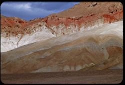
- Description:
- 100 f 6.3 tl
- Subject:
- Black Mountains (Inyo County, Calif.), Death Valley (Calif. and Nev.), Mountains, Rocks, Clouds, and Rock formations
- Series:
- 3-55
- Creator:
- Cushman, Charles W., 1896-1972
- Date Created:
- 1955-02-27
- Genre:
- Landscape photographs
- Frame Number:
- 22
- Street Address:
- Bad Water Road
- County:
- Inyo
- Abstract:
- Red stripe across Black Mtns
- Call Number:
- P07613
- Country:
- United States
- State/Province:
- California
- Alternate Identifier:
- 355.22
- Persistent URL:
- http://purl.dlib.indiana.edu/iudl/archives/cushman/P07613
- Holding Location:
- Bloomington - University Archives
Wells Library E460
1320 E 10th St.
Bloomington, IN 47405
Contact at archives@indiana.edu, 812-855-1127
-
- Description:
- 100 f 8 tl
- Subject:
- Rocks, Valleys, Dantes View (Calif.), Mountains, Shrubs, Clouds, Death Valley National Park (Calif. and Nev.), and Black Mountains (Inyo County, Calif.)
- Series:
- 3-55
- Creator:
- Cushman, Charles W., 1896-1972
- Date Created:
- 1955-02-27
- Genre:
- Landscape photographs
- Frame Number:
- 6
- County:
- Inyo
- Abstract:
- East side of Black Mtns from road below Dante's View from another angle.
- Call Number:
- P07599
- Country:
- United States
- State/Province:
- California
- Alternate Identifier:
- 355.6
- Persistent URL:
- http://purl.dlib.indiana.edu/iudl/archives/cushman/P07599
- Holding Location:
- Bloomington - University Archives
Wells Library E460
1320 E 10th St.
Bloomington, IN 47405
Contact at archives@indiana.edu, 812-855-1127
-
- Description:
- 100 f 5.6 tl
- Subject:
- Rocks, Dantes View (Calif.), Mountains, Shrubs, Clouds, Death Valley (Calif. and Nev.), and Black Mountains (Inyo County, Calif.)
- Series:
- 2-55
- Creator:
- Cushman, Charles W., 1896-1972
- Date Created:
- 1955-02-27
- Genre:
- Landscape photographs
- Frame Number:
- 32
- County:
- Inyo
- Abstract:
- Black Mtns on way to Dante's View from road near Ryan
- Call Number:
- P07589
- City:
- Ryan
- Country:
- United States
- State/Province:
- California
- Alternate Identifier:
- 255.32
- Persistent URL:
- http://purl.dlib.indiana.edu/iudl/archives/cushman/P07589
- Holding Location:
- Bloomington - University Archives
Wells Library E460
1320 E 10th St.
Bloomington, IN 47405
Contact at archives@indiana.edu, 812-855-1127
-
- Description:
- 100 f 6.3
- Subject:
- Rocks, Mountains, Rock formations, Clouds, and Black Mountains (Inyo County, Calif.)
- Series:
- 2-55
- Creator:
- Cushman, Charles W., 1896-1972
- Date Created:
- 1955-02-27
- Genre:
- Landscape photographs
- Frame Number:
- 31
- County:
- Inyo
- Abstract:
- colored rock mass
- Call Number:
- P07588
- Country:
- United States
- State/Province:
- California
- Alternate Identifier:
- 255.31
- Persistent URL:
- http://purl.dlib.indiana.edu/iudl/archives/cushman/P07588
- Holding Location:
- Bloomington - University Archives
Wells Library E460
1320 E 10th St.
Bloomington, IN 47405
Contact at archives@indiana.edu, 812-855-1127
-
- Description:
- 100 f 8 tl
- Subject:
- Hills, Funeral Mountains (Calif.), Funeral Mountains Wilderness (Calif.), Mountains, Shrubs, Furnace Creek (Calif.), Rocks, and Clouds
- Series:
- 2-55
- Creator:
- Cushman, Charles W., 1896-1972
- Date Created:
- 1955-02-27
- Genre:
- Landscape photographs
- Frame Number:
- 29
- Street Address:
- Furance Creek-Death Valley Junction Road
- County:
- Mono and Inyo
- Abstract:
- North toward Funeral Mtns
- Call Number:
- P07586
- City:
- Death Valley Junction
- Country:
- United States
- State/Province:
- California
- Alternate Identifier:
- 255.29
- Persistent URL:
- http://purl.dlib.indiana.edu/iudl/archives/cushman/P07586
- Holding Location:
- Bloomington - University Archives
Wells Library E460
1320 E 10th St.
Bloomington, IN 47405
Contact at archives@indiana.edu, 812-855-1127
-
- Description:
- 200 f 4.5 tl
- Subject:
- Rocks, Dantes View (Calif.), Mountains, Shrubs, Death Valley (Calif. and Nev.), Rock formations, and Furnace Creek Inn (Death Valley Junction, Calif.)
- Series:
- 2-55
- Creator:
- Cushman, Charles W., 1896-1972
- Date Created:
- 1955-02-27
- Genre:
- Landscape photographs
- Frame Number:
- 26
- County:
- Inyo
- Abstract:
- Elephant hide 10 miles SE of Furnace Ck. Inn
- Call Number:
- P07584
- City:
- Death Valley Junction
- Country:
- United States
- State/Province:
- California
- Alternate Identifier:
- 255.26
- Persistent URL:
- http://purl.dlib.indiana.edu/iudl/archives/cushman/P07584
- Holding Location:
- Bloomington - University Archives
Wells Library E460
1320 E 10th St.
Bloomington, IN 47405
Contact at archives@indiana.edu, 812-855-1127
-
- Description:
- 50 f 11 HF
- Subject:
- Valleys, Inyo Mountains (Calif.), Mountains, Owens Valley (Calif.), Deserts, Shrubs, Roads, and Rocks
- Series:
- 12-54
- Creator:
- Cushman, Charles W., 1896-1972
- Date Created:
- 1954-09-18
- Genre:
- Landscape photographs
- Frame Number:
- 27
- Street Address:
- Mt. Whitney Road
- County:
- Inyo
- Abstract:
- Switch-back coming down Mt Whitney rd.
- Call Number:
- P07417
- Country:
- United States
- State/Province:
- California
- Alternate Identifier:
- 1254.27
- Persistent URL:
- http://purl.dlib.indiana.edu/iudl/archives/cushman/P07417
- Holding Location:
- Bloomington - University Archives
Wells Library E460
1320 E 10th St.
Bloomington, IN 47405
Contact at archives@indiana.edu, 812-855-1127
-
- Subject:
- Rocks, Trails & paths, Trees, Mountains, Shrubs, and Whitney, Mount (Calif.)
- Series:
- 12-54
- Creator:
- Cushman, Charles W., 1896-1972
- Date Created:
- 1954-09-17
- Genre:
- Landscape photographs
- Frame Number:
- 26
- Street Address:
- Mt. Whitney Road
- County:
- Inyo
- Abstract:
- Looking back at Mt. Whitney from high up Mt. Whitney road. Backlighted.
- Call Number:
- P07416
- Country:
- United States
- State/Province:
- California
- Physical Description:
- Image was originally mounted in a glass enclosure. Before digitization, the image was removed and placed in a Wess Plastic, Inc. brand, 2" x 2", pl...
- Alternate Identifier:
- 1254.26
- Persistent URL:
- http://purl.dlib.indiana.edu/iudl/archives/cushman/P07416
- Holding Location:
- Bloomington - University Archives
Wells Library E460
1320 E 10th St.
Bloomington, IN 47405
Contact at archives@indiana.edu, 812-855-1127
-
- Description:
- 50 f 12 HF
- Subject:
- Rocks, Valleys, Owens Lake (Inyo County, Calif.), Owens Valley (Calif.), Mountains, Shrubs, Lakes & ponds, Deserts, Trees, and Rock formations
- Series:
- 12-54
- Creator:
- Cushman, Charles W., 1896-1972
- Date Created:
- 1954-09-18
- Genre:
- Landscape photographs
- Frame Number:
- 25
- Street Address:
- Mt. Whitney Road
- County:
- Inyo
- Abstract:
- Owens Dry Lake from high up Mt Whitney rd.
- Call Number:
- P07415
- Country:
- United States
- State/Province:
- California
- Alternate Identifier:
- 1254.25
- Persistent URL:
- http://purl.dlib.indiana.edu/iudl/archives/cushman/P07415
- Holding Location:
- Bloomington - University Archives
Wells Library E460
1320 E 10th St.
Bloomington, IN 47405
Contact at archives@indiana.edu, 812-855-1127
-
- Description:
- 50 f 12 HF
- Subject:
- Rocks, Valleys, Inyo Mountains (Calif.), Trees, Owens Valley (Calif.), Mountains, and Shrubs
- Series:
- 12-54
- Creator:
- Cushman, Charles W., 1896-1972
- Date Created:
- 1954-09-18
- Genre:
- Landscape photographs
- Frame Number:
- 24
- Street Address:
- Mt. Whitney Road
- County:
- Inyo
- Abstract:
- Owens Valley from high up Mt Whitney Rd.
- Call Number:
- P07414
- Country:
- United States
- State/Province:
- California
- Alternate Identifier:
- 1254.24
- Persistent URL:
- http://purl.dlib.indiana.edu/iudl/archives/cushman/P07414
- Holding Location:
- Bloomington - University Archives
Wells Library E460
1320 E 10th St.
Bloomington, IN 47405
Contact at archives@indiana.edu, 812-855-1127
-
- Description:
- 50 f 7.5
- Subject:
- Roads, Whitney, Mount (Calif.), Mountains, Shrubs, Trees, and Rocks
- Series:
- 12-54
- Creator:
- Cushman, Charles W., 1896-1972
- Date Created:
- 1954-09-18
- Genre:
- Landscape photographs
- Frame Number:
- 23
- Street Address:
- Mt. Whitney Road
- County:
- Inyo
- Abstract:
- Closest to Mt Whitney - backlighted.
- Call Number:
- P07413
- Country:
- United States
- State/Province:
- California
- Physical Description:
- Image was originally mounted in a glass enclosure. Before digitization, the image was removed and placed in a Wess Plastic, Inc. brand, 2" x 2", pl...
- Alternate Identifier:
- 1254.23
- Persistent URL:
- http://purl.dlib.indiana.edu/iudl/archives/cushman/P07413
- Holding Location:
- Bloomington - University Archives
Wells Library E460
1320 E 10th St.
Bloomington, IN 47405
Contact at archives@indiana.edu, 812-855-1127
-
- Description:
- ?
- Subject:
- Hills, Automobiles, Whitney, Mount (Calif.), Mountains, Shrubs, Trees, Buildings, Dwellings, and Rocks
- Series:
- 12-54
- Creator:
- Cushman, Charles W., 1896-1972
- Date Created:
- 1954-09-18
- Genre:
- Landscape photographs
- Frame Number:
- 21
- Street Address:
- Mt. Whitney Road
- County:
- Inyo
- Abstract:
- Mt. Whitney revisited.
- Call Number:
- P07411
- City:
- Lone Pine
- Country:
- United States
- State/Province:
- California
- Alternate Identifier:
- 1254.21
- Persistent URL:
- http://purl.dlib.indiana.edu/iudl/archives/cushman/P07411
- Holding Location:
- Bloomington - University Archives
Wells Library E460
1320 E 10th St.
Bloomington, IN 47405
Contact at archives@indiana.edu, 812-855-1127
-
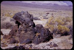
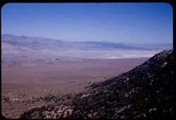
- Description:
- 50 f 8 HF
- Subject:
- Deserts, Owens Valley (Calif.), Rocks, Igneous, Mountains, Shrubs, Sierra Nevada (Calif. and Nev.), Rocks, and Rock formations
- Series:
- 12-54
- Creator:
- Cushman, Charles W., 1896-1972
- Date Created:
- 1954-09-18
- Genre:
- Landscape photographs
- Frame Number:
- 19
- County:
- Inyo
- Abstract:
- Big hunk of lava.
- Call Number:
- P07409
- City:
- Independence and Big Pine
- Country:
- United States
- State/Province:
- California
- Alternate Identifier:
- 1254.19
- Persistent URL:
- http://purl.dlib.indiana.edu/iudl/archives/cushman/P07409
- Holding Location:
- Bloomington - University Archives
Wells Library E460
1320 E 10th St.
Bloomington, IN 47405
Contact at archives@indiana.edu, 812-855-1127
-
- Description:
- 50 f 8 HF
- Subject:
- Rocks, Rocks, Igneous, Owens Valley (Calif.), Mountains, Shrubs, Sierra Nevada (Calif. and Nev.), and Deserts
- Series:
- 12-54
- Creator:
- Cushman, Charles W., 1896-1972
- Date Created:
- 1954-09-18
- Genre:
- Landscape photographs
- Frame Number:
- 18
- County:
- Inyo
- Abstract:
- To show sawteeth - 13 mi. north of Independence. - desert showing lava rock.
- Call Number:
- P07408
- City:
- Big Pine and Independence
- Country:
- United States
- State/Province:
- California
- Physical Description:
- Image was originally mounted in a glass enclosure. Before digitization, the image was removed and placed in a Wess Plastic, Inc. brand, 2" x 2", pl...
- Alternate Identifier:
- 1254.18
- Persistent URL:
- http://purl.dlib.indiana.edu/iudl/archives/cushman/P07408
- Holding Location:
- Bloomington - University Archives
Wells Library E460
1320 E 10th St.
Bloomington, IN 47405
Contact at archives@indiana.edu, 812-855-1127
-
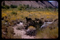
- Description:
- 50 f 9
- Subject:
- Deserts, Glacier Lodge (Calif.), Shrubs, Trees, and Rocks
- Series:
- 12-54
- Creator:
- Cushman, Charles W., 1896-1972
- Date Created:
- 1954-09-18
- Genre:
- Landscape photographs
- Frame Number:
- 14
- County:
- Inyo
- Abstract:
- Tumbled rocks in dry river bed.
- Call Number:
- P07404
- City:
- Big Pine
- Country:
- United States
- State/Province:
- California
- Alternate Identifier:
- 1254.14
- Persistent URL:
- http://purl.dlib.indiana.edu/iudl/archives/cushman/P07404
- Holding Location:
- Bloomington - University Archives
Wells Library E460
1320 E 10th St.
Bloomington, IN 47405
Contact at archives@indiana.edu, 812-855-1127
-
- Description:
- 50 f 8
- Subject:
- Deserts, Valleys, Glacier Lodge (Calif.), Roads, Mountains, Shrubs, Trees, Rocks, and Owens Valley (Calif.)
- Series:
- 12-54
- Creator:
- Cushman, Charles W., 1896-1972
- Date Created:
- 1954-09-18
- Genre:
- Landscape photographs
- Frame Number:
- 12
- Street Address:
- Glacier Lodge Road
- County:
- Inyo
- Abstract:
- Looking down on Big Pine from Glacier Lodge road.
- Call Number:
- P07402
- City:
- Big Pine
- Country:
- United States
- State/Province:
- California
- Alternate Identifier:
- 1254.12
- Persistent URL:
- http://purl.dlib.indiana.edu/iudl/archives/cushman/P07402
- Holding Location:
- Bloomington - University Archives
Wells Library E460
1320 E 10th St.
Bloomington, IN 47405
Contact at archives@indiana.edu, 812-855-1127
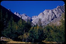
-
- Description:
- 50 f 9
- Subject:
- Rocks, Grasses, Middle Palisade Glacier (Calif.), Trees, Flowers, Mountains, Shrubs, and Sierra Nevada (Calif. and Nev.)
- Series:
- 12-54
- Creator:
- Cushman, Charles W., 1896-1972
- Date Created:
- 1954-09-18
- Genre:
- Landscape photographs
- Frame Number:
- 10
- County:
- Inyo
- Abstract:
- Again - with yellow.
- Call Number:
- P07400
- City:
- Lone Pine
- Country:
- United States
- State/Province:
- California
- Alternate Identifier:
- 1254.10
- Persistent URL:
- http://purl.dlib.indiana.edu/iudl/archives/cushman/P07400
- Holding Location:
- Bloomington - University Archives
Wells Library E460
1320 E 10th St.
Bloomington, IN 47405
Contact at archives@indiana.edu, 812-855-1127
-
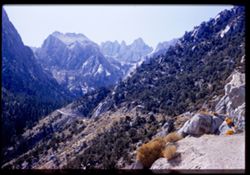
- Description:
- 50 f 11
- Subject:
- Rocks, Middle Palisade Glacier (Calif.), Trees, Mountains, Shrubs, and Sierra Nevada (Calif. and Nev.)
- Series:
- 12-54
- Creator:
- Cushman, Charles W., 1896-1972
- Date Created:
- 1954-09-18
- Genre:
- Landscape photographs
- Frame Number:
- 7
- Street Address:
- Glacier Lodge Road
- County:
- Inyo
- Abstract:
- High ridge SSW from Glacier Lodge. [Middle Palisades]
- Call Number:
- P07397
- City:
- Big Pine
- Country:
- United States
- State/Province:
- California
- Alternate Identifier:
- 1254.7
- Persistent URL:
- http://purl.dlib.indiana.edu/iudl/archives/cushman/P07397
- Holding Location:
- Bloomington - University Archives
Wells Library E460
1320 E 10th St.
Bloomington, IN 47405
Contact at archives@indiana.edu, 812-855-1127
-
- Description:
- 50 f 8
- Subject:
- Bishop Creek (Inyo County, Calif.), Flowers, Donkeys, Animals, Mountains, Shrubs, Trees, Sagebrush, and Rocks
- Series:
- 11-54
- Creator:
- Cushman, Charles W., 1896-1972
- Date Created:
- 1954-09-17
- Genre:
- Identification photographs
- Frame Number:
- 18
- County:
- Inyo
- Abstract:
- Jennie in the sage brush.
- Call Number:
- P07387
- City:
- Bishop
- Country:
- United States
- State/Province:
- California
- Alternate Identifier:
- 1154.18
- Persistent URL:
- http://purl.dlib.indiana.edu/iudl/archives/cushman/P07387
- Holding Location:
- Bloomington - University Archives
Wells Library E460
1320 E 10th St.
Bloomington, IN 47405
Contact at archives@indiana.edu, 812-855-1127
-
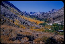
- Description:
- 50 f 9
- Subject:
- Sabrina, Lake (Calif.), Canyons, Roads, Settlements, Mountains, Shrubs, Sierra Nevada (Calif. and Nev.), Trees, Rocks, Bishop Creek Canyon (Calif.), and Dwel...
- Series:
- 11-54
- Creator:
- Cushman, Charles W., 1896-1972
- Date Created:
- 1954-09-17
- Genre:
- Landscape photographs
- Frame Number:
- 17
- County:
- Inyo
- Abstract:
- Back up Bishop Creek canyon in fall color.
- Call Number:
- P07386
- Country:
- United States
- State/Province:
- California
- Alternate Identifier:
- 1154.17
- Persistent URL:
- http://purl.dlib.indiana.edu/iudl/archives/cushman/P07386
- Holding Location:
- Bloomington - University Archives
Wells Library E460
1320 E 10th St.
Bloomington, IN 47405
Contact at archives@indiana.edu, 812-855-1127
-
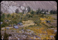
- Description:
- 50 f 8
- Subject:
- Rocks, Canyons, Roads, Settlements, Trees, Shrubs, Dwellings, and Bishop Creek Canyon (Calif.)
- Series:
- 11-54
- Creator:
- Cushman, Charles W., 1896-1972
- Date Created:
- 1954-09-17
- Genre:
- Landscape photographs
- Frame Number:
- 16
- County:
- Inyo
- Abstract:
- Looking down on little old mini settlement.
- Call Number:
- P07385
- City:
- Bishop
- Country:
- United States
- State/Province:
- California
- Alternate Identifier:
- 1154.16
- Persistent URL:
- http://purl.dlib.indiana.edu/iudl/archives/cushman/P07385
- Holding Location:
- Bloomington - University Archives
Wells Library E460
1320 E 10th St.
Bloomington, IN 47405
Contact at archives@indiana.edu, 812-855-1127
-
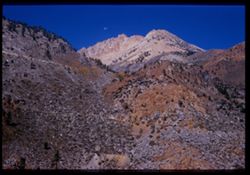
- Description:
- 50 f 11
- Subject:
- Canyons, Moon, Mountains, Shrubs, Sierra Nevada (Calif. and Nev.), Trees, Rocks, and Bishop Creek Canyon (Calif.)
- Series:
- 11-54
- Creator:
- Cushman, Charles W., 1896-1972
- Date Created:
- 1954-09-17
- Genre:
- Landscape photographs
- Frame Number:
- 15
- County:
- Inyo
- Abstract:
- View [L] across Bishop Creek canyon with moon above brown mtn.
- Call Number:
- P07384
- Country:
- United States
- State/Province:
- California
- Physical Description:
- Image was originally mounted in a glass enclosure. Before digitization, the image was removed and placed in a Wess Plastic, Inc. brand, 2" x 2", pl...
- Alternate Identifier:
- 1154.15
- Persistent URL:
- http://purl.dlib.indiana.edu/iudl/archives/cushman/P07384
- Holding Location:
- Bloomington - University Archives
Wells Library E460
1320 E 10th St.
Bloomington, IN 47405
Contact at archives@indiana.edu, 812-855-1127
-
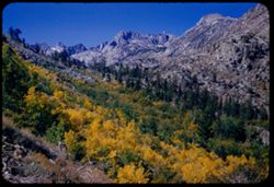
- Description:
- 50 f 9
- Subject:
- Rocks, Canyons, Trees, Mountains, Shrubs, Sierra Nevada (Calif. and Nev.), Sabrina, Lake (Calif.), and Bishop Creek Canyon (Calif.)
- Series:
- 11-54
- Creator:
- Cushman, Charles W., 1896-1972
- Date Created:
- 1954-09-17
- Genre:
- Landscape photographs
- Frame Number:
- 14
- County:
- Inyo
- Abstract:
- View back up canyon toward high mtns.
- Call Number:
- P07383
- Country:
- United States
- State/Province:
- California
- Alternate Identifier:
- 1154.14
- Persistent URL:
- http://purl.dlib.indiana.edu/iudl/archives/cushman/P07383
- Holding Location:
- Bloomington - University Archives
Wells Library E460
1320 E 10th St.
Bloomington, IN 47405
Contact at archives@indiana.edu, 812-855-1127
-
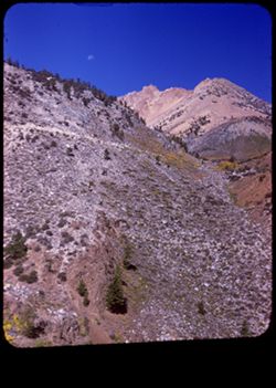
- Description:
- 50 f 9
- Subject:
- Rocks, Canyons, Crown Mountain, Trees, Moon Mountain, Moon, Mountains, Shrubs, Sierra Nevada (Calif. and Nev.), Sabrina, Lake (Calif.), and Bishop Creek Cany...
- Series:
- 11-54
- Creator:
- Cushman, Charles W., 1896-1972
- Date Created:
- 1954-09-17
- Genre:
- Landscape photographs
- Frame Number:
- 13
- County:
- Inyo
- Abstract:
- View NW across Bishop Creek Canyon to Moon + Crown mtn [ ] [P] Mt. Emerson?
- Call Number:
- P07382
- Country:
- United States
- State/Province:
- California
- Physical Description:
- masked.
- Alternate Identifier:
- 1154.13
- Persistent URL:
- http://purl.dlib.indiana.edu/iudl/archives/cushman/P07382
- Holding Location:
- Bloomington - University Archives
Wells Library E460
1320 E 10th St.
Bloomington, IN 47405
Contact at archives@indiana.edu, 812-855-1127
-
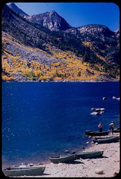
- Description:
- 50 f 8
- Subject:
- Rocks, Bodies of water, Trees, Mountains, Shrubs, Lakes & ponds, Rowboats, Sierra Nevada (Calif. and Nev.), Sabrina, Lake (Calif.), Boats, and People
- Series:
- 11-54
- Creator:
- Cushman, Charles W., 1896-1972
- Date Created:
- 1954-09-11
- Genre:
- Landscape photographs
- Frame Number:
- 11
- County:
- Inyo
- Abstract:
- [P] Across Sabrina Lake toward yellow-leaved mountain slopes.
- Call Number:
- P07380
- City:
- Bishop
- Country:
- United States
- State/Province:
- California
- Alternate Identifier:
- 1154.11
- Persistent URL:
- http://purl.dlib.indiana.edu/iudl/archives/cushman/P07380
- Holding Location:
- Bloomington - University Archives
Wells Library E460
1320 E 10th St.
Bloomington, IN 47405
Contact at archives@indiana.edu, 812-855-1127
-
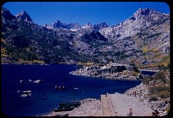
- Description:
- 50 f 10
- Subject:
- Rocks, Bodies of water, Trees, Mountains, Shrubs, Lakes & ponds, Rowboats, Islands, Sabrina, Lake (Calif.), Boats, Sierra Nevada (Calif. and Nev.), and P...
- Series:
- 11-54
- Creator:
- Cushman, Charles W., 1896-1972
- Date Created:
- 1954-09-17
- Genre:
- Landscape photographs
- Frame Number:
- 12
- County:
- Inyo
- Abstract:
- SSW across Sabrina Lake to high mtn.
- Call Number:
- P07381
- City:
- Bishop
- Country:
- United States
- State/Province:
- California
- Alternate Identifier:
- 1154.12
- Persistent URL:
- http://purl.dlib.indiana.edu/iudl/archives/cushman/P07381
- Holding Location:
- Bloomington - University Archives
Wells Library E460
1320 E 10th St.
Bloomington, IN 47405
Contact at archives@indiana.edu, 812-855-1127
-
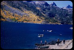
- Description:
- 50 f 8
- Subject:
- Rocks, Bodies of water, Trees, Mountains, Shrubs, Lakes & ponds, Rowboats, Sabrina, Lake (Calif.), Boats, and People
- Series:
- 11-54
- Creator:
- Cushman, Charles W., 1896-1972
- Date Created:
- 1954-09-17
- Genre:
- Landscape photographs
- Frame Number:
- 10
- County:
- Inyo
- Abstract:
- [L] Across Sabrina Lake toward yellow-leaved mountain slopes.
- Call Number:
- P07379
- City:
- Bishop
- Country:
- United States
- State/Province:
- California
- Alternate Identifier:
- 1154.10
- Persistent URL:
- http://purl.dlib.indiana.edu/iudl/archives/cushman/P07379
- Holding Location:
- Bloomington - University Archives
Wells Library E460
1320 E 10th St.
Bloomington, IN 47405
Contact at archives@indiana.edu, 812-855-1127
-
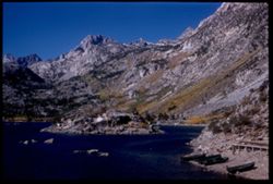
- Description:
- 50 f 10
- Subject:
- Rocks, Piers & wharves, Bodies of water, Trees, Mountains, Shrubs, Lakes & ponds, Rowboats, Islands, Sabrina, Lake (Calif.), Boats, and Sierra Nevada...
- Series:
- 11-54
- Creator:
- Cushman, Charles W., 1896-1972
- Date Created:
- 1954-09-17
- Genre:
- Landscape photographs
- Frame Number:
- 9
- County:
- Inyo
- Abstract:
- Sabrina Lake with an island - end of the road.
- Call Number:
- P07378
- City:
- Bishop
- Country:
- United States
- State/Province:
- California
- Physical Description:
- Image was originally mounted in a glass enclosure. Before digitization, the image was removed and placed in a Wess Plastic, Inc. brand, 2" x 2", pl...
- Alternate Identifier:
- 1154.9
- Persistent URL:
- http://purl.dlib.indiana.edu/iudl/archives/cushman/P07378
- Holding Location:
- Bloomington - University Archives
Wells Library E460
1320 E 10th St.
Bloomington, IN 47405
Contact at archives@indiana.edu, 812-855-1127
-
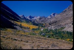
- Description:
- 50 f 10
- Subject:
- Sabrina, Lake (Calif.), Canyons, Valleys, Mountains, Shrubs, Sierra Nevada (Calif. and Nev.), Trees, Rocks, and Dwellings
- Series:
- 11-54
- Creator:
- Cushman, Charles W., 1896-1972
- Date Created:
- 1954-09-17
- Genre:
- Landscape photographs
- Frame Number:
- 8
- County:
- Inyo
- Abstract:
- Up canyon of yellow trees.
- Call Number:
- P07377
- Country:
- United States
- State/Province:
- California
- Alternate Identifier:
- 1154.8
- Persistent URL:
- http://purl.dlib.indiana.edu/iudl/archives/cushman/P07377
- Holding Location:
- Bloomington - University Archives
Wells Library E460
1320 E 10th St.
Bloomington, IN 47405
Contact at archives@indiana.edu, 812-855-1127
-
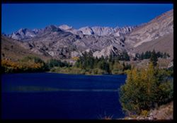
- Description:
- 50 f 9
- Subject:
- Bishop Creek (Inyo County, Calif.), Lakes & ponds, Bodies of water, Mountains, Shrubs, Sierra Nevada (Calif. and Nev.), Reservoirs, Rocks, and Trees
- Series:
- 11-54
- Creator:
- Cushman, Charles W., 1896-1972
- Date Created:
- 1954-09-17
- Genre:
- Landscape photographs
- Frame Number:
- 6
- County:
- Inyo
- Abstract:
- Across little lake to high Sierra.
- Call Number:
- P07375
- Country:
- United States
- State/Province:
- California
- Physical Description:
- Image was originally mounted in a glass enclosure. Before digitization, the image was removed and placed in a Wess Plastic, Inc. brand, 2" x 2", pl...
- Alternate Identifier:
- 1154.6
- Persistent URL:
- http://purl.dlib.indiana.edu/iudl/archives/cushman/P07375
- Holding Location:
- Bloomington - University Archives
Wells Library E460
1320 E 10th St.
Bloomington, IN 47405
Contact at archives@indiana.edu, 812-855-1127
-
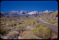
- Description:
- 50 f 9
- Subject:
- Flowers, Hills, Roads, Mountains, Shrubs, Sierra Nevada (Calif. and Nev.), Trees, Rocks, and Grasses
- Series:
- 11-54
- Creator:
- Cushman, Charles W., 1896-1972
- Date Created:
- 1954-09-17
- Genre:
- Landscape photographs
- Frame Number:
- 5
- Street Address:
- Sabrina Lake Road
- County:
- Inyo
- Abstract:
- High Sierra seen from Sabrina Lake road SW of Bishop.
- Call Number:
- P07374
- City:
- Bishop
- Country:
- United States
- State/Province:
- California
- Alternate Identifier:
- 1154.5
- Persistent URL:
- http://purl.dlib.indiana.edu/iudl/archives/cushman/P07374
- Holding Location:
- Bloomington - University Archives
Wells Library E460
1320 E 10th St.
Bloomington, IN 47405
Contact at archives@indiana.edu, 812-855-1127
-
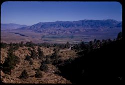
- Description:
- 50 f 8 Haze F
- Subject:
- Valleys, Rocks, Bishop Peak (Calif.), Mountains, Trees, Owens Valley (Calif.), Shadows, Shrubs, and Roads
- Series:
- 11-54
- Creator:
- Cushman, Charles W., 1896-1972
- Date Created:
- 1954-09-16
- Genre:
- Landscape photographs
- Frame Number:
- 4
- Street Address:
- United States Highway 395, United States Highway 6/395, and California State Highway 14
- County:
- Inyo
- Abstract:
- View south toward Owens valley where Bishop lies.
- Call Number:
- P07373
- Country:
- United States
- State/Province:
- California
- Alternate Identifier:
- 1154.4
- Persistent URL:
- http://purl.dlib.indiana.edu/iudl/archives/cushman/P07373
- Holding Location:
- Bloomington - University Archives
Wells Library E460
1320 E 10th St.
Bloomington, IN 47405
Contact at archives@indiana.edu, 812-855-1127
-

- Description:
- 25 f 13
- Subject:
- Rocks, Colored mountains, Valleys, Cliffs, Mountains, Rock formations, Death Valley (Calif. and Nev.), Deserts, and Hills
- Series:
- 15-52
- Creator:
- Cushman, Charles W., 1896-1972
- Date Created:
- 1952-04-09
- Genre:
- Landscape photographs
- Frame Number:
- 38
- Street Address:
- Artists Drive
- County:
- Inyo
- Abstract:
- From top of Artists Drive. Off Artists Drive.
- Call Number:
- P06057
- Country:
- United States
- State/Province:
- California
- Alternate Identifier:
- 1552.38
- Persistent URL:
- http://purl.dlib.indiana.edu/iudl/archives/cushman/P06057
- Holding Location:
- Bloomington - University Archives
Wells Library E460
1320 E 10th St.
Bloomington, IN 47405
Contact at archives@indiana.edu, 812-855-1127
-
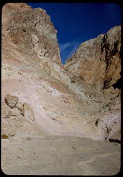
- Description:
- 25 f 16
- Subject:
- Rocks, Valleys, Cliffs, Boulders, Mountains, Death Valley (Calif. and Nev.), and Deserts
- Series:
- 15-52
- Creator:
- Cushman, Charles W., 1896-1972
- Date Created:
- 1952-04-09
- Genre:
- Landscape photographs
- Frame Number:
- 37
- Street Address:
- Artists Drive
- County:
- Inyo
- Abstract:
- From top of Artists Drive. Up from Artists Dr.
- Call Number:
- P06056
- Country:
- United States
- State/Province:
- California
- Alternate Identifier:
- 1552.37
- Persistent URL:
- http://purl.dlib.indiana.edu/iudl/archives/cushman/P06056
- Holding Location:
- Bloomington - University Archives
Wells Library E460
1320 E 10th St.
Bloomington, IN 47405
Contact at archives@indiana.edu, 812-855-1127
-
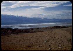
- Description:
- 25 f 8 Pola
- Subject:
- Deserts, Valleys, Hills, Death Valley (Calif. and Nev.), Mountains, Rocks, and Clouds
- Series:
- 15-52
- Creator:
- Cushman, Charles W., 1896-1972
- Date Created:
- 1952-04-09
- Genre:
- Landscape photographs
- Frame Number:
- 35
- Street Address:
- Artists Drive
- County:
- Inyo
- Abstract:
- From top of Artists Drive. Back across valley.
- Call Number:
- P06054
- Country:
- United States
- State/Province:
- California
- Alternate Identifier:
- 1552.35
- Persistent URL:
- http://purl.dlib.indiana.edu/iudl/archives/cushman/P06054
- Holding Location:
- Bloomington - University Archives
Wells Library E460
1320 E 10th St.
Bloomington, IN 47405
Contact at archives@indiana.edu, 812-855-1127
-
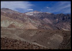
- Description:
- 25 f 13
- Subject:
- Rocks, Colored mountains, Valleys, Cliffs, Boulders, Mountains, Rock formations, Death Valley (Calif. and Nev.), Deserts, and Hills
- Series:
- 15-52
- Creator:
- Cushman, Charles W., 1896-1972
- Date Created:
- 1952-04-09
- Genre:
- Landscape photographs
- Frame Number:
- 33
- Street Address:
- Artists Drive
- County:
- Inyo
- Abstract:
- Colored mtns from Artists Drive.
- Call Number:
- P06052
- Country:
- United States
- State/Province:
- California
- Physical Description:
- Image was originally mounted in a glass enclosure. Before digitization, the image was removed and placed in a Wess Plastic, Inc. brand, 2" x 2", pl...
- Alternate Identifier:
- 1552.33
- Persistent URL:
- http://purl.dlib.indiana.edu/iudl/archives/cushman/P06052
- Holding Location:
- Bloomington - University Archives
Wells Library E460
1320 E 10th St.
Bloomington, IN 47405
Contact at archives@indiana.edu, 812-855-1127
-
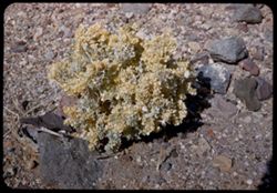
- Description:
- 25 f 16
- Subject:
- Valleys, Rocks, Death Valley (Calif. and Nev.), Deserts, and Shrubs
- Series:
- 15-52
- Creator:
- Cushman, Charles W., 1896-1972
- Date Created:
- 1952-04-09
- Genre:
- Identification photographs
- Frame Number:
- 32
- County:
- Inyo
- Abstract:
- Desert holly.
- Call Number:
- P06051
- Country:
- United States
- State/Province:
- California
- Alternate Identifier:
- 1552.32
- Persistent URL:
- http://purl.dlib.indiana.edu/iudl/archives/cushman/P06051
- Holding Location:
- Bloomington - University Archives
Wells Library E460
1320 E 10th St.
Bloomington, IN 47405
Contact at archives@indiana.edu, 812-855-1127