
Search Constraints
You searched for:
Campus
IUB
Remove constraint Campus: IUB
County
Inyo
Remove constraint County: Inyo
Subject
Sierra Nevada (Calif. and Nev.)
Remove constraint Subject: Sierra Nevada (Calif. and Nev.)
1 - 65 of 65
Search Results
-
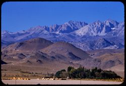
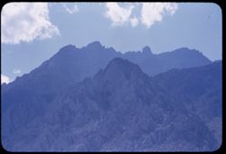
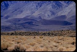
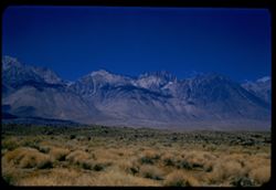
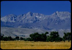
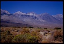
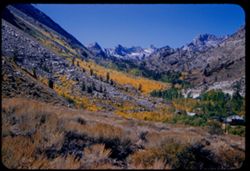
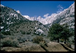
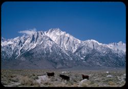
- Description:
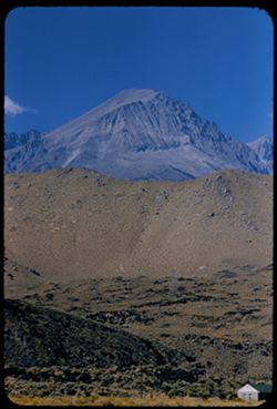
- 100 f 7 tl
- Subject:
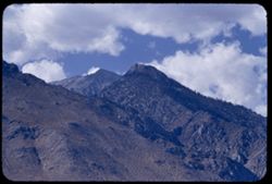
- Trees, Mountains, Tom, Mount (Inyo County, Calif.), Facilities, Sierra Nevada (Calif. and Nev.), Hills, and Utility poles
- Series:
- 26-55
- Creator:
- Cushman, Charles W., 1896-1972
- Date Created:
- 1955-09-26
- Genre:
- Landscape photographs
- Frame Number:
- 33
- Street Address:
- United States Highway 395
- County:
- Inyo
- Abstract:
- Distant ridge further south of Mt Tom
- Call Number:
- P08415
- City:
- Bishop
- Country:
- United States
- State/Province:
- California
- Alternate Identifier:
- 2655.33
- Persistent URL:
- http://purl.dlib.indiana.edu/iudl/archives/cushman/P08415
- Holding Location:
- Bloomington - University Archives
Wells Library E460
1320 E 10th St.
Bloomington, IN 47405
Contact at archives@indiana.edu, 812-855-1127
-
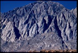
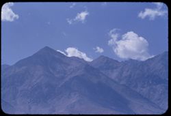
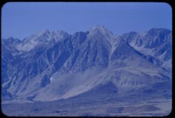
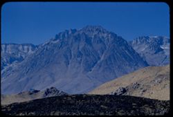
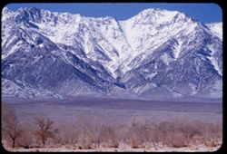
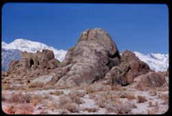
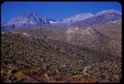
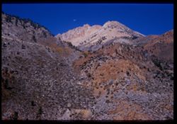
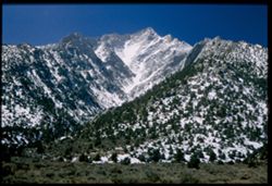
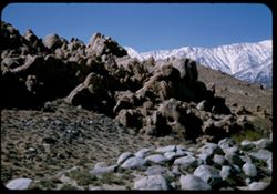
- Description:
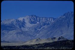
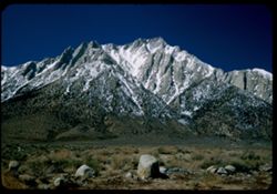
- 100 f 8 tl
- Subject:
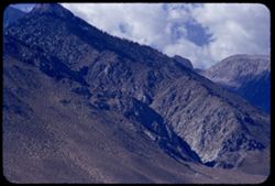
- Mountains, Rock formations, Tom, Mount (Inyo County, Calif.), and Sierra Nevada (Calif. and Nev.)
- Series:
- 26-55
- Creator:
- Cushman, Charles W., 1896-1972
- Date Created:
- 1955-09-26
- Genre:
- Landscape photographs
- Frame Number:
- 34
- County:
- Inyo
- Abstract:
- Chiseled face of huge mtn. NW of Tom
- Call Number:
- P08416
- Country:
- United States
- State/Province:
- California
- Physical Description:
- Image was originally mounted in a glass enclosure. Before digitization, the image was removed and placed in a Wess Plastic, Inc. brand, 2" x 2", pl...
- Alternate Identifier:
- 2655.34
- Persistent URL:
- http://purl.dlib.indiana.edu/iudl/archives/cushman/P08416
- Holding Location:
- Bloomington - University Archives
Wells Library E460
1320 E 10th St.
Bloomington, IN 47405
Contact at archives@indiana.edu, 812-855-1127
-
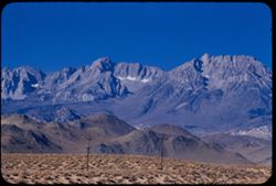
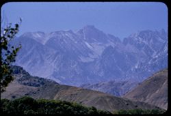
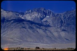
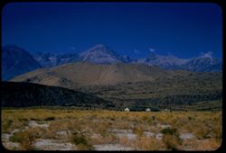
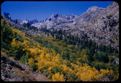
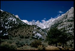
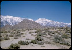
- Description:
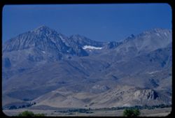
- 100 f 8 tl
- Subject:
- Plains, Mountains, Tom, Mount (Inyo County, Calif.), Sierra Nevada (Calif. and Nev.), Hills, and Utility poles
- Series:
- 26-55
- Creator:
- Cushman, Charles W., 1896-1972
- Date Created:
- 1955-09-26
- Genre:
- Landscape photographs
- Frame Number:
- 32
- County:
- Inyo
- Abstract:
- Ridge south of Mt Tom
- Call Number:
- P08414
- City:
- Bishop
- Country:
- United States
- State/Province:
- California
- Alternate Identifier:
- 2655.32
- Persistent URL:
- http://purl.dlib.indiana.edu/iudl/archives/cushman/P08414
- Holding Location:
- Bloomington - University Archives
Wells Library E460
1320 E 10th St.
Bloomington, IN 47405
Contact at archives@indiana.edu, 812-855-1127
-
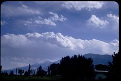
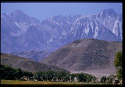
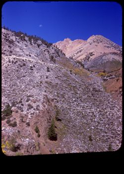
- Description:
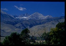
- 100 f 6.3 sl with 50mm
- Subject:
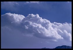
- Mountains, Sierra Nevada (Calif. and Nev.), Trees, and Clouds
- Series:
- 26-55
- Creator:
- Cushman, Charles W., 1896-1972
- Date Created:
- 1955-09-25
- Genre:
- Landscape photographs
- Frame Number:
- 23
- County:
- Inyo
- Abstract:
- Cloud mass over Sierra - from Bishop
- Call Number:
- P08405
- City:
- Bishop
- Country:
- United States
- State/Province:
- California
- Alternate Identifier:
- 2655.23
- Persistent URL:
- http://purl.dlib.indiana.edu/iudl/archives/cushman/P08405
- Holding Location:
- Bloomington - University Archives
Wells Library E460
1320 E 10th St.
Bloomington, IN 47405
Contact at archives@indiana.edu, 812-855-1127
-
- Description:
- 100 f 8 tl
- Subject:
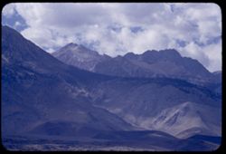
- Mountains, Clouds, and Sierra Nevada (Calif. and Nev.)
- Series:
- 26-55
- Creator:
- Cushman, Charles W., 1896-1972
- Date Created:
- 1955-09-25
- Genre:
- Landscape photographs
- Frame Number:
- 22
- County:
- Inyo
- Abstract:
- Cloud mass over Sierra - from Bishop
- Call Number:
- P08404
- City:
- Bishop
- Country:
- United States
- State/Province:
- California
- Physical Description:
- Image was originally mounted in a glass enclosure. Before digitization, the image was removed and placed in a Wess Plastic, Inc. brand, 2" x 2", pl...
- Alternate Identifier:
- 2655.22
- Persistent URL:
- http://purl.dlib.indiana.edu/iudl/archives/cushman/P08404
- Holding Location:
- Bloomington - University Archives
Wells Library E460
1320 E 10th St.
Bloomington, IN 47405
Contact at archives@indiana.edu, 812-855-1127
-
- Description:
- 100 f 5.6 tl
- Subject:
- Owens Valley (Calif.), Mountains, Clouds, and Sierra Nevada (Calif. and Nev.)
- Series:
- 26-55
- Creator:
- Cushman, Charles W., 1896-1972
- Date Created:
- 1955-09-25
- Genre:
- Landscape photographs
- Frame Number:
- 18
- County:
- Inyo
- Abstract:
- Another bit of saw tooth
- Call Number:
- P08401
- City:
- Big Pine and Independence
- Country:
- United States
- State/Province:
- California
- Alternate Identifier:
- 2655.18
- Persistent URL:
- http://purl.dlib.indiana.edu/iudl/archives/cushman/P08401
- Holding Location:
- Bloomington - University Archives
Wells Library E460
1320 E 10th St.
Bloomington, IN 47405
Contact at archives@indiana.edu, 812-855-1127
-
- Description:
- 100 f 6.3 tl
- Subject:
- Mountains, Sierra Nevada (Calif. and Nev.), and Clouds
- Series:
- 26-55
- Creator:
- Cushman, Charles W., 1896-1972
- Date Created:
- 1955-09-25
- Genre:
- Landscape photographs
- Frame Number:
- 16
- Street Address:
- United States Highway 395 and United States Highway 6
- County:
- Inyo
- Abstract:
- From US 6/395 between Independence & Big Pine - toward a [push?] in the high Sierra
- Call Number:
- P08399
- City:
- Independence and Big Pine
- Country:
- United States
- State/Province:
- California
- Alternate Identifier:
- 2655.16
- Persistent URL:
- http://purl.dlib.indiana.edu/iudl/archives/cushman/P08399
- Holding Location:
- Bloomington - University Archives
Wells Library E460
1320 E 10th St.
Bloomington, IN 47405
Contact at archives@indiana.edu, 812-855-1127
-
- Description:
- 100 f 6.3 tl
- Subject:
- Mountains, Clouds, and Sierra Nevada (Calif. and Nev.)
- Series:
- 26-55
- Creator:
- Cushman, Charles W., 1896-1972
- Date Created:
- 1955-09-25
- Genre:
- Landscape photographs
- Frame Number:
- 15
- Street Address:
- United States Highway 6 and United States Highway 395
- County:
- Inyo
- Abstract:
- From US 6/395 between Independence & Big Pine - toward a [push?] in the high Sierra
- Call Number:
- P08398
- City:
- Big Pine and Independence
- Country:
- United States
- State/Province:
- California
- Alternate Identifier:
- 2655.15
- Persistent URL:
- http://purl.dlib.indiana.edu/iudl/archives/cushman/P08398
- Holding Location:
- Bloomington - University Archives
Wells Library E460
1320 E 10th St.
Bloomington, IN 47405
Contact at archives@indiana.edu, 812-855-1127
-
- Description:
- 100 f 5.6 tl
- Subject:
- Mountains, Light, Clouds, and Sierra Nevada (Calif. and Nev.)
- Series:
- 26-55
- Creator:
- Cushman, Charles W., 1896-1972
- Date Created:
- 1955-09-25
- Genre:
- Landscape photographs
- Frame Number:
- 17
- Street Address:
- United States Highway 6 and United States Highway 395
- County:
- Inyo
- Abstract:
- Backdrop of high Sierra from US 6/395 between Independence & Big Pine (back ltd)
- Call Number:
- P08400
- City:
- Big Pine and Independence
- Country:
- United States
- State/Province:
- California
- Alternate Identifier:
- 2655.17
- Persistent URL:
- http://purl.dlib.indiana.edu/iudl/archives/cushman/P08400
- Holding Location:
- Bloomington - University Archives
Wells Library E460
1320 E 10th St.
Bloomington, IN 47405
Contact at archives@indiana.edu, 812-855-1127
-
- Description:
- 100 f 6.3 tl
- Subject:
- Mountains, Clouds, and Sierra Nevada (Calif. and Nev.)
- Series:
- 26-55
- Creator:
- Cushman, Charles W., 1896-1972
- Date Created:
- 1955-09-25
- Genre:
- Landscape photographs
- Frame Number:
- 13
- Street Address:
- United States Highway 395
- County:
- Inyo
- Abstract:
- After lunch = Tp of Sierra ridge from Hwy so. of Independence back lighted
- Call Number:
- P08396
- City:
- Independence
- Country:
- United States
- State/Province:
- California
- Alternate Identifier:
- 2655.13
- Persistent URL:
- http://purl.dlib.indiana.edu/iudl/archives/cushman/P08396
- Holding Location:
- Bloomington - University Archives
Wells Library E460
1320 E 10th St.
Bloomington, IN 47405
Contact at archives@indiana.edu, 812-855-1127
-
- Description:
- 100 f 6.3
- Subject:
- Hills, Whitney, Mount (Calif.), Mountains, Sierra Nevada (Calif. and Nev.), Trees, Corcoran, Mount (Calif.), and Le Conte, Mount (Calif.)
- Series:
- 26-55
- Creator:
- Cushman, Charles W., 1896-1972
- Date Created:
- 1955-09-25
- Genre:
- Landscape photographs
- Frame Number:
- 11
- County:
- Inyo
- Abstract:
- And a little further to south (perhaps Mt. Corcoran)
- Call Number:
- P08394
- Country:
- United States
- State/Province:
- California
- Alternate Identifier:
- 2655.11
- Persistent URL:
- http://purl.dlib.indiana.edu/iudl/archives/cushman/P08394
- Holding Location:
- Bloomington - University Archives
Wells Library E460
1320 E 10th St.
Bloomington, IN 47405
Contact at archives@indiana.edu, 812-855-1127
-
- Description:
- 100 f 5.6 tl
- Subject:
- Hills, Initials, Whitney, Mount (Calif.), Mountains, Sierra Nevada (Calif. and Nev.), Le Conte, Mount (Calif.), Corcoran, Mount (Calif.), and Trees
- Series:
- 26-55
- Creator:
- Cushman, Charles W., 1896-1972
- Date Created:
- 1955-09-25
- Genre:
- Landscape photographs
- Frame Number:
- 10
- County:
- Inyo
- Abstract:
- Perhaps Le Conte? and Corcoran? south of Lone Pine Mtns
- Call Number:
- P08393
- City:
- Lone Pine
- Country:
- United States
- State/Province:
- California
- Physical Description:
- Image was originally mounted in a glass enclosure. Before digitization, the image was removed and placed in a Wess Plastic, Inc. brand, 2" x 2", pl...
- Alternate Identifier:
- 2655.10
- Persistent URL:
- http://purl.dlib.indiana.edu/iudl/archives/cushman/P08393
- Holding Location:
- Bloomington - University Archives
Wells Library E460
1320 E 10th St.
Bloomington, IN 47405
Contact at archives@indiana.edu, 812-855-1127
-
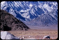
- Description:
- 100 f 6.3
- Subject:
- Rocks, Grasses, Mountains, Sierra Nevada (Calif. and Nev.), and Hills
- Series:
- 26-55
- Creator:
- Cushman, Charles W., 1896-1972
- Date Created:
- 1955-09-25
- Genre:
- Landscape photographs
- Frame Number:
- 3
- County:
- Inyo
- Abstract:
- Looking at base of range to SSW
- Call Number:
- P08386
- City:
- Big Pine and Independence
- Country:
- United States
- State/Province:
- California
- Alternate Identifier:
- 2655.3
- Persistent URL:
- http://purl.dlib.indiana.edu/iudl/archives/cushman/P08386
- Holding Location:
- Bloomington - University Archives
Wells Library E460
1320 E 10th St.
Bloomington, IN 47405
Contact at archives@indiana.edu, 812-855-1127
-
- Description:
- 100 f 6.3 tl
- Subject:
- Mountains and Sierra Nevada (Calif. and Nev.)
- Series:
- 26-55
- Creator:
- Cushman, Charles W., 1896-1972
- Date Created:
- 1955-09-25
- Genre:
- Landscape photographs
- Frame Number:
- 2
- Street Address:
- United States Highway 395
- County:
- Inyo
- Abstract:
- SW from same spot
- Call Number:
- P08385
- City:
- Independence
- Country:
- United States
- State/Province:
- California
- Alternate Identifier:
- 2655.2
- Persistent URL:
- http://purl.dlib.indiana.edu/iudl/archives/cushman/P08385
- Holding Location:
- Bloomington - University Archives
Wells Library E460
1320 E 10th St.
Bloomington, IN 47405
Contact at archives@indiana.edu, 812-855-1127
-
- Description:
- 100 f 8 tl
- Subject:
- Mountains, Land, and Sierra Nevada (Calif. and Nev.)
- Series:
- 26-55
- Creator:
- Cushman, Charles W., 1896-1972
- Date Created:
- 1955-09-25
- Genre:
- Landscape photographs
- Frame Number:
- 1
- Street Address:
- United States Highway 395
- County:
- Inyo
- Abstract:
- Mtn with the dark top strip (see 25-55-36/37)
- Call Number:
- P08384
- Country:
- United States
- State/Province:
- California
- Alternate Identifier:
- 2655.1
- Persistent URL:
- http://purl.dlib.indiana.edu/iudl/archives/cushman/P08384
- Holding Location:
- Bloomington - University Archives
Wells Library E460
1320 E 10th St.
Bloomington, IN 47405
Contact at archives@indiana.edu, 812-855-1127
-
- Description:
- 100 f 8 TL
- Subject:
- Mountains and Sierra Nevada (Calif. and Nev.)
- Series:
- 25-55
- Creator:
- Cushman, Charles W., 1896-1972
- Date Created:
- 1955-09-25
- Genre:
- Landscape photographs
- Frame Number:
- 37
- County:
- Inyo
- Abstract:
- The mtn with horizontal stripes - from 13 mi. so. Of Big Pine
- Call Number:
- P08382
- City:
- Big Pine and Independence
- Country:
- United States
- State/Province:
- California
- Physical Description:
- Image was originally mounted in a glass enclosure. Before digitization, the image was removed and placed in a Wess Plastic, Inc. brand, 2" x 2", pl...
- Alternate Identifier:
- 2555.37
- Persistent URL:
- http://purl.dlib.indiana.edu/iudl/archives/cushman/P08382
- Holding Location:
- Bloomington - University Archives
Wells Library E460
1320 E 10th St.
Bloomington, IN 47405
Contact at archives@indiana.edu, 812-855-1127
-
- Description:
- 100 f 8 SL
- Subject:
- Grasses, Plains, Owens Valley (Calif.), Mountains, and Sierra Nevada (Calif. and Nev.)
- Series:
- 25-55
- Creator:
- Cushman, Charles W., 1896-1972
- Date Created:
- 1955-09-25
- Genre:
- Landscape photographs
- Frame Number:
- 36
- County:
- Inyo
- Abstract:
- The mtn with horizontal stripes - from 13 mi. so. Of Big Pine
- Call Number:
- P08381
- City:
- Big Pine
- Country:
- United States
- State/Province:
- California
- Alternate Identifier:
- 2555.36
- Persistent URL:
- http://purl.dlib.indiana.edu/iudl/archives/cushman/P08381
- Holding Location:
- Bloomington - University Archives
Wells Library E460
1320 E 10th St.
Bloomington, IN 47405
Contact at archives@indiana.edu, 812-855-1127
-
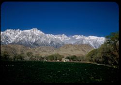
- Description:
- 100 f 8 SL
- Subject:
- Houses, Plains, Owens Valley (Calif.), Mountains, Sierra Nevada (Calif. and Nev.), Hills, and Plants
- Series:
- 25-55
- Creator:
- Cushman, Charles W., 1896-1972
- Date Created:
- 1955-09-25
- Genre:
- Landscape photographs
- Frame Number:
- 35
- County:
- Inyo
- Abstract:
- And looking west
- Call Number:
- P08380
- City:
- Big Pine
- Country:
- United States
- State/Province:
- California
- Alternate Identifier:
- 2555.35
- Persistent URL:
- http://purl.dlib.indiana.edu/iudl/archives/cushman/P08380
- Holding Location:
- Bloomington - University Archives
Wells Library E460
1320 E 10th St.
Bloomington, IN 47405
Contact at archives@indiana.edu, 812-855-1127
-
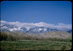
- Description:
- 100 f 6.3 SL
- Subject:
- Plains, Owens Valley (Calif.), Mounds (Landforms), Mountains, Sierra Nevada (Calif. and Nev.), and Grasses
- Series:
- 25-55
- Creator:
- Cushman, Charles W., 1896-1972
- Date Created:
- 1955-09-25
- Genre:
- Landscape photographs
- Frame Number:
- 34
- County:
- Inyo
- Abstract:
- The whole view looking SW -
- Call Number:
- P08379
- City:
- Big Pine
- Country:
- United States
- State/Province:
- California
- Alternate Identifier:
- 2555.34
- Persistent URL:
- http://purl.dlib.indiana.edu/iudl/archives/cushman/P08379
- Holding Location:
- Bloomington - University Archives
Wells Library E460
1320 E 10th St.
Bloomington, IN 47405
Contact at archives@indiana.edu, 812-855-1127
-
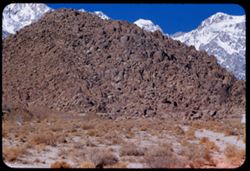
- Description:
- 100 f 6.3 TL
- Subject:
- Rocks, Owens Valley (Calif.), Mountains, Land, and Sierra Nevada (Calif. and Nev.)
- Series:
- 25-55
- Creator:
- Cushman, Charles W., 1896-1972
- Date Created:
- 1955-09-25
- Genre:
- Landscape photographs
- Frame Number:
- 33
- County:
- Inyo
- Abstract:
- Like a huge chocolate drop
- Call Number:
- P08378
- City:
- Big Pine
- Country:
- United States
- State/Province:
- California
- Alternate Identifier:
- 2555.33
- Persistent URL:
- http://purl.dlib.indiana.edu/iudl/archives/cushman/P08378
- Holding Location:
- Bloomington - University Archives
Wells Library E460
1320 E 10th St.
Bloomington, IN 47405
Contact at archives@indiana.edu, 812-855-1127
-
- Description:
- 100 f 8 TL
- Subject:
- Houses, Owens Valley (Calif.), Mountains, Land, and Sierra Nevada (Calif. and Nev.)
- Series:
- 25-55
- Creator:
- Cushman, Charles W., 1896-1972
- Date Created:
- 1955-09-25
- Genre:
- Landscape photographs
- Frame Number:
- 32
- Street Address:
- United States Highway 395
- County:
- Inyo
- Abstract:
- From same pt. Due west to Mtn with truncated profile [P]
- Call Number:
- P08377
- City:
- Big Pine
- Country:
- United States
- State/Province:
- California
- Alternate Identifier:
- 2555.32
- Persistent URL:
- http://purl.dlib.indiana.edu/iudl/archives/cushman/P08377
- Holding Location:
- Bloomington - University Archives
Wells Library E460
1320 E 10th St.
Bloomington, IN 47405
Contact at archives@indiana.edu, 812-855-1127
-
- Description:
- 100 f 7 TL
- Subject:
- Mounds (Landforms), Mountains, and Sierra Nevada (Calif. and Nev.)
- Series:
- 25-55
- Creator:
- Cushman, Charles W., 1896-1972
- Date Created:
- 1955-09-25
- Genre:
- Landscape photographs
- Frame Number:
- 31
- Street Address:
- United States Highway 395
- County:
- Inyo
- Abstract:
- Mtn with chocolate icing from pt. 5 mi. so. of Big Pine
- Call Number:
- P08376
- City:
- Big Pine
- Country:
- United States
- State/Province:
- California
- Alternate Identifier:
- 2555.31
- Persistent URL:
- http://purl.dlib.indiana.edu/iudl/archives/cushman/P08376
- Holding Location:
- Bloomington - University Archives
Wells Library E460
1320 E 10th St.
Bloomington, IN 47405
Contact at archives@indiana.edu, 812-855-1127
-
- Description:
- 100 f 6.3 TL
- Subject:
- Snow, Mountains, and Sierra Nevada (Calif. and Nev.)
- Series:
- 25-55
- Creator:
- Cushman, Charles W., 1896-1972
- Date Created:
- 1955-09-25
- Genre:
- Landscape photographs
- Frame Number:
- 30
- County:
- Inyo
- Abstract:
- up and SW back from Big Pine
- Call Number:
- P08375
- City:
- Big Pine
- Country:
- United States
- State/Province:
- California
- Alternate Identifier:
- 2555.30
- Persistent URL:
- http://purl.dlib.indiana.edu/iudl/archives/cushman/P08375
- Holding Location:
- Bloomington - University Archives
Wells Library E460
1320 E 10th St.
Bloomington, IN 47405
Contact at archives@indiana.edu, 812-855-1127
-
- Description:
- 100 f 8 TL
- Subject:
- Snow, Trees, Palisade Glacier (Calif.), Tree limbs, Mountains, Clouds, and Sierra Nevada (Calif. and Nev.)
- Series:
- 25-55
- Creator:
- Cushman, Charles W., 1896-1972
- Date Created:
- 1955-09-25
- Genre:
- Landscape photographs
- Frame Number:
- 29
- County:
- Inyo
- Abstract:
- Palisade (?) west of Big Pine
- Call Number:
- P08374
- City:
- Big Pine
- Country:
- United States
- State/Province:
- California
- Physical Description:
- Image was originally mounted in a glass enclosure. Before digitization, the image was removed and placed in a Wess Plastic, Inc. brand, 2" x 2", pl...
- Alternate Identifier:
- 2555.29
- Persistent URL:
- http://purl.dlib.indiana.edu/iudl/archives/cushman/P08374
- Holding Location:
- Bloomington - University Archives
Wells Library E460
1320 E 10th St.
Bloomington, IN 47405
Contact at archives@indiana.edu, 812-855-1127
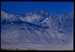
-
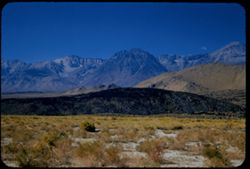
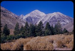
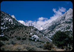
- Description:
- 100 f 8 TL
- Subject:
- Grasses, Trees, Mountains, Tom, Mount (Inyo County, Calif.), and Sierra Nevada (Calif. and Nev.)
- Series:
- 25-55
- Creator:
- Cushman, Charles W., 1896-1972
- Date Created:
- 1955-09-25
- Genre:
- Landscape photographs
- Frame Number:
- 26
- County:
- Inyo
- Abstract:
- Ridge of high Sierra south of Mt. Tom
- Call Number:
- P08373
- City:
- Bishop
- Country:
- United States
- State/Province:
- California
- Alternate Identifier:
- 2555.26
- Persistent URL:
- http://purl.dlib.indiana.edu/iudl/archives/cushman/P08373
- Holding Location:
- Bloomington - University Archives
Wells Library E460
1320 E 10th St.
Bloomington, IN 47405
Contact at archives@indiana.edu, 812-855-1127
-
- Description:
- 100 f 5.6
- Subject:
- Snow, Valleys, Trees, Mountains, Williamson, Mount (Inyo County, Calif.), Shrubs, and Sierra Nevada (Calif. and Nev.)
- Series:
- 4-55
- Creator:
- Cushman, Charles W., 1896-1972
- Date Created:
- 1955-02-28
- Genre:
- Landscape photographs
- Frame Number:
- 13
- Street Address:
- United States Highway 6
- County:
- Inyo
- Abstract:
- Mtns north of Williamson
- Call Number:
- P07640
- Country:
- United States
- State/Province:
- California
- Alternate Identifier:
- 455.13
- Persistent URL:
- http://purl.dlib.indiana.edu/iudl/archives/cushman/P07640
- Holding Location:
- Bloomington - University Archives
Wells Library E460
1320 E 10th St.
Bloomington, IN 47405
Contact at archives@indiana.edu, 812-855-1127
-
- Description:
- 100 f 8 tl
- Subject:
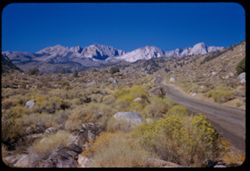
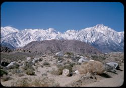
- Hills, Mountains, Shrubs, Snow, Boulders, Rocks, Fences, Sierra Nevada (Calif. and Nev.), and Alabama Hills (Calif.)
- Series:
- 4-55
- Creator:
- Cushman, Charles W., 1896-1972
- Date Created:
- 1955-02-28
- Genre:
- Landscape photographs
- Frame Number:
- 5
- County:
- Inyo
- Abstract:
- Ala Hills & back of roof of Sierra
- Call Number:
- P07633
- Country:
- United States
- State/Province:
- California
- Alternate Identifier:
- 455.5
- Persistent URL:
- http://purl.dlib.indiana.edu/iudl/archives/cushman/P07633
- Holding Location:
- Bloomington - University Archives
Wells Library E460
1320 E 10th St.
Bloomington, IN 47405
Contact at archives@indiana.edu, 812-855-1127
-
- Description:
- 100 f 5.6
- Subject:
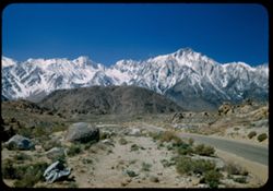
- Snow, Valleys, Trees, Lone Pine Peak (Calif.), Mountains, Shrubs, Sierra Nevada (Calif. and Nev.), Hills, and Rocks
- Series:
- 4-55
- Creator:
- Cushman, Charles W., 1896-1972
- Date Created:
- 1955-02-28
- Genre:
- Landscape photographs
- Frame Number:
- 6
- County:
- Inyo
- Abstract:
- Sierra south of Lone Pine Pk
- Call Number:
- P07634
- Country:
- United States
- State/Province:
- California
- Alternate Identifier:
- 455.6
- Persistent URL:
- http://purl.dlib.indiana.edu/iudl/archives/cushman/P07634
- Holding Location:
- Bloomington - University Archives
Wells Library E460
1320 E 10th St.
Bloomington, IN 47405
Contact at archives@indiana.edu, 812-855-1127
-
- Description:
- 100 f 5.6 tl
- Subject:
- Hills, Mountains, Sierra Nevada (Calif. and Nev.), Alabama Hills (Calif.), Rock formations, and Snow
- Series:
- 4-55
- Creator:
- Cushman, Charles W., 1896-1972
- Date Created:
- 1955-02-28
- Genre:
- Landscape photographs
- Frame Number:
- 4
- County:
- Inyo
- Abstract:
- In alabama Hills
- Call Number:
- P07632
- City:
- Lone Pine
- Country:
- United States
- State/Province:
- California
- Alternate Identifier:
- 455.4
- Persistent URL:
- http://purl.dlib.indiana.edu/iudl/archives/cushman/P07632
- Holding Location:
- Bloomington - University Archives
Wells Library E460
1320 E 10th St.
Bloomington, IN 47405
Contact at archives@indiana.edu, 812-855-1127
-
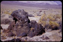
- Description:
- 50 f 8 HF
- Subject:
- Deserts, Owens Valley (Calif.), Rocks, Igneous, Mountains, Shrubs, Sierra Nevada (Calif. and Nev.), Rocks, and Rock formations
- Series:
- 12-54
- Creator:
- Cushman, Charles W., 1896-1972
- Date Created:
- 1954-09-18
- Genre:
- Landscape photographs
- Frame Number:
- 19
- County:
- Inyo
- Abstract:
- Big hunk of lava.
- Call Number:
- P07409
- City:
- Independence and Big Pine
- Country:
- United States
- State/Province:
- California
- Alternate Identifier:
- 1254.19
- Persistent URL:
- http://purl.dlib.indiana.edu/iudl/archives/cushman/P07409
- Holding Location:
- Bloomington - University Archives
Wells Library E460
1320 E 10th St.
Bloomington, IN 47405
Contact at archives@indiana.edu, 812-855-1127
-
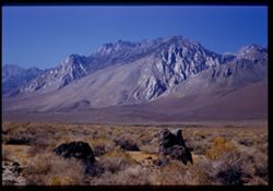
- Description:
- 50 f 8 HF
- Subject:
- Rocks, Rocks, Igneous, Owens Valley (Calif.), Mountains, Shrubs, Sierra Nevada (Calif. and Nev.), and Deserts
- Series:
- 12-54
- Creator:
- Cushman, Charles W., 1896-1972
- Date Created:
- 1954-09-18
- Genre:
- Landscape photographs
- Frame Number:
- 18
- County:
- Inyo
- Abstract:
- To show sawteeth - 13 mi. north of Independence. - desert showing lava rock.
- Call Number:
- P07408
- City:
- Big Pine and Independence
- Country:
- United States
- State/Province:
- California
- Physical Description:
- Image was originally mounted in a glass enclosure. Before digitization, the image was removed and placed in a Wess Plastic, Inc. brand, 2" x 2", pl...
- Alternate Identifier:
- 1254.18
- Persistent URL:
- http://purl.dlib.indiana.edu/iudl/archives/cushman/P07408
- Holding Location:
- Bloomington - University Archives
Wells Library E460
1320 E 10th St.
Bloomington, IN 47405
Contact at archives@indiana.edu, 812-855-1127
-
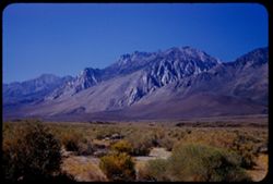
- Description:
- 50 f 9 HF
- Subject:
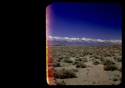
- Deserts, Owens Valley (Calif.), Mountains, Shrubs, and Sierra Nevada (Calif. and Nev.)
- Series:
- 12-54
- Creator:
- Cushman, Charles W., 1896-1972
- Date Created:
- 1954-09-18
- Genre:
- Landscape photographs
- Frame Number:
- 17
- Street Address:
- United States Highway 6 and United States Highway 395
- County:
- Inyo
- Abstract:
- To show sawteeth - 13 mi. north of Independence.
- Call Number:
- P07407
- City:
- Big Pine and Independence
- Country:
- United States
- State/Province:
- California
- Alternate Identifier:
- 1254.17
- Persistent URL:
- http://purl.dlib.indiana.edu/iudl/archives/cushman/P07407
- Holding Location:
- Bloomington - University Archives
Wells Library E460
1320 E 10th St.
Bloomington, IN 47405
Contact at archives@indiana.edu, 812-855-1127
-
- Description:
- 50 f 11
- Subject:
- Deserts, Owens Valley (Calif.), Mountains, Shrubs, and Sierra Nevada (Calif. and Nev.)
- Series:
- 12-54
- Creator:
- Cushman, Charles W., 1896-1972
- Date Created:
- 1954-09-18
- Genre:
- Landscape photographs
- Frame Number:
- 16
- County:
- Inyo
- Abstract:
- Again from a mile further south.
- Call Number:
- P07406
- City:
- Independence and Big Pine
- Country:
- United States
- State/Province:
- California
- Physical Description:
- Image was originally mounted in a glass enclosure. Before digitization, the image was removed and placed in a Wess Plastic, Inc. brand, 2" x 2", pl...
- Alternate Identifier:
- 1254.16
- Persistent URL:
- http://purl.dlib.indiana.edu/iudl/archives/cushman/P07406
- Holding Location:
- Bloomington - University Archives
Wells Library E460
1320 E 10th St.
Bloomington, IN 47405
Contact at archives@indiana.edu, 812-855-1127
-
- Description:
- 50 f 11
- Subject:
- Deserts, Glacier Lodge (Calif.), Mountains, Shrubs, Sierra Nevada (Calif. and Nev.), and Middle Palisade Glacier (Calif.)
- Series:
- 12-54
- Creator:
- Cushman, Charles W., 1896-1972
- Date Created:
- 1954-09-18
- Genre:
- Landscape photographs
- Frame Number:
- 13
- Street Address:
- Glacier Lodge Road
- County:
- Inyo
- Abstract:
- Looking SW up Glacier Lodge road at 1020 am DST.
- Call Number:
- P07403
- City:
- Big Pine
- Country:
- United States
- State/Province:
- California
- Alternate Identifier:
- 1254.13
- Persistent URL:
- http://purl.dlib.indiana.edu/iudl/archives/cushman/P07403
- Holding Location:
- Bloomington - University Archives
Wells Library E460
1320 E 10th St.
Bloomington, IN 47405
Contact at archives@indiana.edu, 812-855-1127
-
- Description:
- 50 f 11
- Subject:
- Deserts, Middle Palisade Glacier (Calif.), Trees, Mountains, Shrubs, Sierra Nevada (Calif. and Nev.), and Glacier Lodge (Calif.)
- Series:
- 12-54
- Creator:
- Cushman, Charles W., 1896-1972
- Date Created:
- 1954-09-18
- Genre:
- Landscape photographs
- Frame Number:
- 11
- County:
- Inyo
- Abstract:
- Again [L]
- Call Number:
- P07401
- City:
- Lone Pine
- Country:
- United States
- State/Province:
- California
- Alternate Identifier:
- 1254.11
- Persistent URL:
- http://purl.dlib.indiana.edu/iudl/archives/cushman/P07401
- Holding Location:
- Bloomington - University Archives
Wells Library E460
1320 E 10th St.
Bloomington, IN 47405
Contact at archives@indiana.edu, 812-855-1127
-
- Description:
- 50 f 9
- Subject:
- Rocks, Grasses, Middle Palisade Glacier (Calif.), Trees, Flowers, Mountains, Shrubs, and Sierra Nevada (Calif. and Nev.)
- Series:
- 12-54
- Creator:
- Cushman, Charles W., 1896-1972
- Date Created:
- 1954-09-18
- Genre:
- Landscape photographs
- Frame Number:
- 10
- County:
- Inyo
- Abstract:
- Again - with yellow.
- Call Number:
- P07400
- City:
- Lone Pine
- Country:
- United States
- State/Province:
- California
- Alternate Identifier:
- 1254.10
- Persistent URL:
- http://purl.dlib.indiana.edu/iudl/archives/cushman/P07400
- Holding Location:
- Bloomington - University Archives
Wells Library E460
1320 E 10th St.
Bloomington, IN 47405
Contact at archives@indiana.edu, 812-855-1127
-
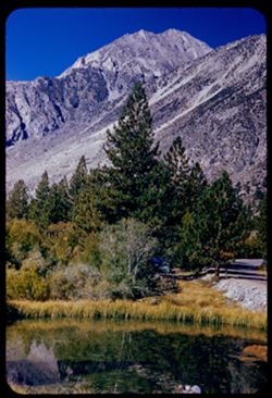
- Description:
- 50 f 9
- Subject:
- Bodies of water, Mountains, Trees, Shrubs, Lakes & ponds, Reflections, and Sierra Nevada (Calif. and Nev.)
- Series:
- 12-54
- Creator:
- Cushman, Charles W., 1896-1972
- Date Created:
- 1954-09-18
- Genre:
- Landscape photographs
- Frame Number:
- 9
- Street Address:
- Glacier Lodge Road
- County:
- Inyo
- Abstract:
- Same peak - with pool + pine.
- Call Number:
- P07399
- City:
- Big Pine
- Country:
- United States
- State/Province:
- California
- Alternate Identifier:
- 1254.9
- Persistent URL:
- http://purl.dlib.indiana.edu/iudl/archives/cushman/P07399
- Holding Location:
- Bloomington - University Archives
Wells Library E460
1320 E 10th St.
Bloomington, IN 47405
Contact at archives@indiana.edu, 812-855-1127
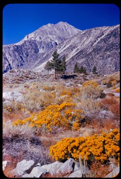
-
- Description:
- 50 f 10
- Subject:
- Mountains, Shrubs, Sierra Nevada (Calif. and Nev.), and Grasses
- Series:
- 12-54
- Creator:
- Cushman, Charles W., 1896-1972
- Date Created:
- 1954-09-18
- Genre:
- Landscape photographs
- Frame Number:
- 8
- Street Address:
- Glacier Lodge Road
- County:
- Inyo
- Abstract:
- White top of Pyramidal peak - from Glacier Lodge.
- Call Number:
- P07398
- City:
- Big Pine
- Country:
- United States
- State/Province:
- California
- Alternate Identifier:
- 1254.8
- Persistent URL:
- http://purl.dlib.indiana.edu/iudl/archives/cushman/P07398
- Holding Location:
- Bloomington - University Archives
Wells Library E460
1320 E 10th St.
Bloomington, IN 47405
Contact at archives@indiana.edu, 812-855-1127
-
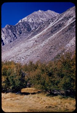
- Description:
- 50 f 11
- Subject:
- Rocks, Middle Palisade Glacier (Calif.), Trees, Mountains, Shrubs, and Sierra Nevada (Calif. and Nev.)
- Series:
- 12-54
- Creator:
- Cushman, Charles W., 1896-1972
- Date Created:
- 1954-09-18
- Genre:
- Landscape photographs
- Frame Number:
- 7
- Street Address:
- Glacier Lodge Road
- County:
- Inyo
- Abstract:
- High ridge SSW from Glacier Lodge. [Middle Palisades]
- Call Number:
- P07397
- City:
- Big Pine
- Country:
- United States
- State/Province:
- California
- Alternate Identifier:
- 1254.7
- Persistent URL:
- http://purl.dlib.indiana.edu/iudl/archives/cushman/P07397
- Holding Location:
- Bloomington - University Archives
Wells Library E460
1320 E 10th St.
Bloomington, IN 47405
Contact at archives@indiana.edu, 812-855-1127
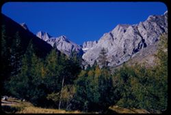
-
- Description:
- 50 f 11
- Subject:
- Middle Palisade Glacier (Calif.), Trees, Flowers, Mountains, Shrubs, and Sierra Nevada (Calif. and Nev.)
- Series:
- 12-54
- Creator:
- Cushman, Charles W., 1896-1972
- Date Created:
- 1954-09-18
- Genre:
- Landscape photographs
- Frame Number:
- 6
- Street Address:
- Glacier Lodge Road
- County:
- Inyo
- Abstract:
- High Sierra west of Big Pine - from Glacier Lodge road.
- Call Number:
- P07396
- City:
- Big Pine
- Country:
- United States
- State/Province:
- California
- Physical Description:
- film scratched.
- Alternate Identifier:
- 1254.6
- Persistent URL:
- http://purl.dlib.indiana.edu/iudl/archives/cushman/P07396
- Holding Location:
- Bloomington - University Archives
Wells Library E460
1320 E 10th St.
Bloomington, IN 47405
Contact at archives@indiana.edu, 812-855-1127
-
- Description:
- 50 f 9
- Subject:
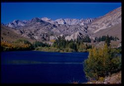
- Sabrina, Lake (Calif.), Canyons, Roads, Settlements, Mountains, Shrubs, Sierra Nevada (Calif. and Nev.), Trees, Rocks, Bishop Creek Canyon (Calif.), and Dwel...
- Series:
- 11-54
- Creator:
- Cushman, Charles W., 1896-1972
- Date Created:
- 1954-09-17
- Genre:
- Landscape photographs
- Frame Number:
- 17
- County:
- Inyo
- Abstract:
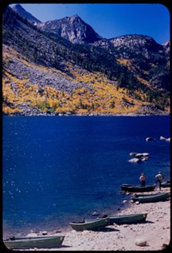
- Back up Bishop Creek canyon in fall color.
- Call Number:
- P07386
- Country:
- United States
- State/Province:
- California
- Alternate Identifier:
- 1154.17
- Persistent URL:
- http://purl.dlib.indiana.edu/iudl/archives/cushman/P07386
- Holding Location:
- Bloomington - University Archives
Wells Library E460
1320 E 10th St.
Bloomington, IN 47405
Contact at archives@indiana.edu, 812-855-1127
-
- Description:
- 50 f 11
- Subject:
- Canyons, Moon, Mountains, Shrubs, Sierra Nevada (Calif. and Nev.), Trees, Rocks, and Bishop Creek Canyon (Calif.)
- Series:
- 11-54
- Creator:
- Cushman, Charles W., 1896-1972
- Date Created:
- 1954-09-17
- Genre:
- Landscape photographs
- Frame Number:
- 15
- County:
- Inyo
- Abstract:
- View [L] across Bishop Creek canyon with moon above brown mtn.
- Call Number:
- P07384
- Country:
- United States
- State/Province:
- California
- Physical Description:
- Image was originally mounted in a glass enclosure. Before digitization, the image was removed and placed in a Wess Plastic, Inc. brand, 2" x 2", pl...
- Alternate Identifier:
- 1154.15
- Persistent URL:
- http://purl.dlib.indiana.edu/iudl/archives/cushman/P07384
- Holding Location:
- Bloomington - University Archives
Wells Library E460
1320 E 10th St.
Bloomington, IN 47405
Contact at archives@indiana.edu, 812-855-1127
-
- Description:
- 50 f 9
- Subject:
- Rocks, Canyons, Trees, Mountains, Shrubs, Sierra Nevada (Calif. and Nev.), Sabrina, Lake (Calif.), and Bishop Creek Canyon (Calif.)
- Series:
- 11-54
- Creator:
- Cushman, Charles W., 1896-1972
- Date Created:
- 1954-09-17
- Genre:
- Landscape photographs
- Frame Number:
- 14
- County:
- Inyo
- Abstract:
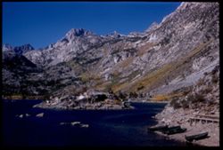
- View back up canyon toward high mtns.
- Call Number:
- P07383
- Country:
- United States
- State/Province:
- California
- Alternate Identifier:
- 1154.14
- Persistent URL:
- http://purl.dlib.indiana.edu/iudl/archives/cushman/P07383
- Holding Location:
- Bloomington - University Archives
Wells Library E460
1320 E 10th St.
Bloomington, IN 47405
Contact at archives@indiana.edu, 812-855-1127
-
- Description:
- 50 f 9
- Subject:
- Rocks, Canyons, Crown Mountain, Trees, Moon Mountain, Moon, Mountains, Shrubs, Sierra Nevada (Calif. and Nev.), Sabrina, Lake (Calif.), and Bishop Creek Cany...
- Series:
- 11-54
- Creator:
- Cushman, Charles W., 1896-1972
- Date Created:
- 1954-09-17
- Genre:
- Landscape photographs
- Frame Number:
- 13
- County:
- Inyo
- Abstract:
- View NW across Bishop Creek Canyon to Moon + Crown mtn [ ] [P] Mt. Emerson?
- Call Number:
- P07382
- Country:
- United States
- State/Province:
- California
- Physical Description:
- masked.
- Alternate Identifier:
- 1154.13
- Persistent URL:
- http://purl.dlib.indiana.edu/iudl/archives/cushman/P07382
- Holding Location:
- Bloomington - University Archives
Wells Library E460
1320 E 10th St.
Bloomington, IN 47405
Contact at archives@indiana.edu, 812-855-1127
-
- Description:
- 50 f 8
- Subject:
- Rocks, Bodies of water, Trees, Mountains, Shrubs, Lakes & ponds, Rowboats, Sierra Nevada (Calif. and Nev.), Sabrina, Lake (Calif.), Boats, and People
- Series:
- 11-54
- Creator:
- Cushman, Charles W., 1896-1972
- Date Created:
- 1954-09-11
- Genre:
- Landscape photographs
- Frame Number:
- 11
- County:
- Inyo
- Abstract:
- [P] Across Sabrina Lake toward yellow-leaved mountain slopes.
- Call Number:
- P07380
- City:
- Bishop
- Country:
- United States
- State/Province:
- California
- Alternate Identifier:
- 1154.11
- Persistent URL:
- http://purl.dlib.indiana.edu/iudl/archives/cushman/P07380
- Holding Location:
- Bloomington - University Archives
Wells Library E460
1320 E 10th St.
Bloomington, IN 47405
Contact at archives@indiana.edu, 812-855-1127
-
- Description:
- 50 f 10
- Subject:
- Rocks, Bodies of water, Trees, Mountains, Shrubs, Lakes & ponds, Rowboats, Islands, Sabrina, Lake (Calif.), Boats, Sierra Nevada (Calif. and Nev.), and P...
- Series:
- 11-54
- Creator:
- Cushman, Charles W., 1896-1972
- Date Created:
- 1954-09-17
- Genre:
- Landscape photographs
- Frame Number:
- 12
- County:
- Inyo
- Abstract:
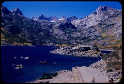
- SSW across Sabrina Lake to high mtn.
- Call Number:
- P07381
- City:
- Bishop
- Country:
- United States
- State/Province:
- California
- Alternate Identifier:
- 1154.12
- Persistent URL:
- http://purl.dlib.indiana.edu/iudl/archives/cushman/P07381
- Holding Location:
- Bloomington - University Archives
Wells Library E460
1320 E 10th St.
Bloomington, IN 47405
Contact at archives@indiana.edu, 812-855-1127
-
- Description:
- 50 f 10
- Subject:
- Rocks, Piers & wharves, Bodies of water, Trees, Mountains, Shrubs, Lakes & ponds, Rowboats, Islands, Sabrina, Lake (Calif.), Boats, and Sierra Nevada...
- Series:
- 11-54
- Creator:
- Cushman, Charles W., 1896-1972
- Date Created:
- 1954-09-17
- Genre:
- Landscape photographs
- Frame Number:
- 9
- County:
- Inyo
- Abstract:
- Sabrina Lake with an island - end of the road.
- Call Number:
- P07378
- City:
- Bishop
- Country:
- United States
- State/Province:
- California
- Physical Description:
- Image was originally mounted in a glass enclosure. Before digitization, the image was removed and placed in a Wess Plastic, Inc. brand, 2" x 2", pl...
- Alternate Identifier:
- 1154.9
- Persistent URL:
- http://purl.dlib.indiana.edu/iudl/archives/cushman/P07378
- Holding Location:
- Bloomington - University Archives
Wells Library E460
1320 E 10th St.
Bloomington, IN 47405
Contact at archives@indiana.edu, 812-855-1127
-
- Description:
- 50 f 10
- Subject:
- Sabrina, Lake (Calif.), Canyons, Valleys, Mountains, Shrubs, Sierra Nevada (Calif. and Nev.), Trees, Rocks, and Dwellings
- Series:
- 11-54
- Creator:
- Cushman, Charles W., 1896-1972
- Date Created:
- 1954-09-17
- Genre:
- Landscape photographs
- Frame Number:
- 8
- County:
- Inyo
- Abstract:
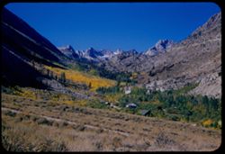
- Up canyon of yellow trees.
- Call Number:
- P07377
- Country:
- United States
- State/Province:
- California
- Alternate Identifier:
- 1154.8
- Persistent URL:
- http://purl.dlib.indiana.edu/iudl/archives/cushman/P07377
- Holding Location:
- Bloomington - University Archives
Wells Library E460
1320 E 10th St.
Bloomington, IN 47405
Contact at archives@indiana.edu, 812-855-1127
-
- Description:
- 50 f 9
- Subject:
- Bishop Creek (Inyo County, Calif.), Lakes & ponds, Bodies of water, Mountains, Shrubs, Sierra Nevada (Calif. and Nev.), Reservoirs, Rocks, and Trees
- Series:
- 11-54
- Creator:
- Cushman, Charles W., 1896-1972
- Date Created:
- 1954-09-17
- Genre:
- Landscape photographs
- Frame Number:
- 6
- County:
- Inyo
- Abstract:
- Across little lake to high Sierra.
- Call Number:
- P07375
- Country:
- United States
- State/Province:
- California
- Physical Description:
- Image was originally mounted in a glass enclosure. Before digitization, the image was removed and placed in a Wess Plastic, Inc. brand, 2" x 2", pl...
- Alternate Identifier:
- 1154.6
- Persistent URL:
- http://purl.dlib.indiana.edu/iudl/archives/cushman/P07375
- Holding Location:
- Bloomington - University Archives
Wells Library E460
1320 E 10th St.
Bloomington, IN 47405
Contact at archives@indiana.edu, 812-855-1127
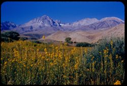
-
- Description:
- 50 f 9
- Subject:
- Flowers, Hills, Roads, Mountains, Shrubs, Sierra Nevada (Calif. and Nev.), Trees, Rocks, and Grasses
- Series:
- 11-54
- Creator:
- Cushman, Charles W., 1896-1972
- Date Created:
- 1954-09-17
- Genre:
- Landscape photographs
- Frame Number:
- 5
- Street Address:
- Sabrina Lake Road
- County:
- Inyo
- Abstract:
- High Sierra seen from Sabrina Lake road SW of Bishop.
- Call Number:
- P07374
- City:
- Bishop
- Country:
- United States
- State/Province:
- California
- Alternate Identifier:
- 1154.5
- Persistent URL:
- http://purl.dlib.indiana.edu/iudl/archives/cushman/P07374
- Holding Location:
- Bloomington - University Archives
Wells Library E460
1320 E 10th St.
Bloomington, IN 47405
Contact at archives@indiana.edu, 812-855-1127
-
- Description:
- 25 f 8 Pola
- Subject:
- Snow, Mountains, Shrubs, Sierra Nevada (Calif. and Nev.), and Hills
- Series:
- 15-52
- Creator:
- Cushman, Charles W., 1896-1972
- Date Created:
- 1952-04-08
- Genre:
- Landscape photographs
- Frame Number:
- 1
- Street Address:
- California State Highway 190
- County:
- Inyo
- Abstract:
- The very high Sierras from Hwy 190 twenty five miles east of Lone Pine.
- Call Number:
- P06022
- City:
- Lone Pine
- Country:
- United States
- State/Province:
- California
- Physical Description:
- masked.
- Alternate Identifier:
- 1552.1
- Persistent URL:
- http://purl.dlib.indiana.edu/iudl/archives/cushman/P06022
- Holding Location:
- Bloomington - University Archives
Wells Library E460
1320 E 10th St.
Bloomington, IN 47405
Contact at archives@indiana.edu, 812-855-1127
-
- Description:
- 25 f 8 Pola
- Subject:
- Snow, Roads, Boulders, Mountains, Rock formations, Whitney, Mount (Calif.), Sierra Nevada (Calif. and Nev.), Hills, Rocks, Lone Pine Peak (Calif.), and Shrubs
- Series:
- 14-52
- Creator:
- Cushman, Charles W., 1896-1972
- Date Created:
- 1952-04-08
- Genre:
- Landscape photographs
- Frame Number:
- 37
- County:
- Inyo
- Abstract:
- Whitney's neighbors + the south again.
- Call Number:
- P06020
- Country:
- United States
- State/Province:
- California
- Alternate Identifier:
- 1452.37
- Persistent URL:
- http://purl.dlib.indiana.edu/iudl/archives/cushman/P06020
- Holding Location:
- Bloomington - University Archives
Wells Library E460
1320 E 10th St.
Bloomington, IN 47405
Contact at archives@indiana.edu, 812-855-1127
-
- Description:
- 25 f 13
- Subject:
- Snow, Roads, Trees, Mountains, Rock formations, Whitney, Mount (Calif.), Sierra Nevada (Calif. and Nev.), Shrubs, and Clouds
- Series:
- 14-52
- Creator:
- Cushman, Charles W., 1896-1972
- Date Created:
- 1952-04-08
- Genre:
- Landscape photographs
- Frame Number:
- 28
- County:
- Inyo
- Abstract:
- Mt. Whitney + spires.
- Call Number:
- P06012
- Country:
- United States
- State/Province:
- California
- Physical Description:
- Image was originally mounted in a glass enclosure. Before digitization, the image was removed and placed in a Wess Plastic, Inc. brand, 2" x 2", pl...
- Alternate Identifier:
- 1452.28
- Persistent URL:
- http://purl.dlib.indiana.edu/iudl/archives/cushman/P06012
- Holding Location:
- Bloomington - University Archives
Wells Library E460
1320 E 10th St.
Bloomington, IN 47405
Contact at archives@indiana.edu, 812-855-1127
-
- Description:
- 25 f 9 Pola
- Subject:
- Snow, Trees, Mountains, Shrubs, Whitney, Mount (Calif.), Sierra Nevada (Calif. and Nev.), Rock formations, and Clouds
- Series:
- 14-52
- Creator:
- Cushman, Charles W., 1896-1972
- Date Created:
- 1952-04-08
- Genre:
- Landscape photographs
- Frame Number:
- 27
- Street Address:
- Lone Pine-Whitney Road
- County:
- Placer and Inyo
- Abstract:
- Mt. Whitney + spires.
- Call Number:
- P06011
- City:
- Lone Pine
- Country:
- United States
- State/Province:
- California
- Physical Description:
- Image was originally mounted in a glass enclosure. Before digitization, the image was removed and placed in a Wess Plastic, Inc. brand, 2" x 2", pl...
- Alternate Identifier:
- 1452.27
- Persistent URL:
- http://purl.dlib.indiana.edu/iudl/archives/cushman/P06011
- Holding Location:
- Bloomington - University Archives
Wells Library E460
1320 E 10th St.
Bloomington, IN 47405
Contact at archives@indiana.edu, 812-855-1127
-
- Description:
- 25 f 6.3 Pola
- Subject:
- Snow, Trees, Mountains, Shrubs, Whitney, Mount (Calif.), Sierra Nevada (Calif. and Nev.), and Langley, Mount (Calif.)
- Series:
- 14-52
- Creator:
- Cushman, Charles W., 1896-1972
- Date Created:
- 1952-04-08
- Genre:
- Landscape photographs
- Frame Number:
- 26
- County:
- Inyo
- Abstract:
- Whitney's SE neighbor again. Mt. Langley, 14,042.
- Call Number:
- P06010
- City:
- Lone Pine
- Country:
- United States
- State/Province:
- California
- Physical Description:
- Image was originally mounted in a glass enclosure. Before digitization, the image was removed and placed in a Wess Plastic, Inc. brand, 2" x 2", pl...
- Alternate Identifier:
- 1452.26
- Persistent URL:
- http://purl.dlib.indiana.edu/iudl/archives/cushman/P06010
- Holding Location:
- Bloomington - University Archives
Wells Library E460
1320 E 10th St.
Bloomington, IN 47405
Contact at archives@indiana.edu, 812-855-1127
-
- Description:
- 25 f 13
- Subject:
- Snow, Trees, Mountains, Shrubs, Whitney, Mount (Calif.), Sierra Nevada (Calif. and Nev.), and Clouds
- Series:
- 14-52
- Creator:
- Cushman, Charles W., 1896-1972
- Date Created:
- 1952-04-08
- Genre:
- Landscape photographs
- Frame Number:
- 25
- County:
- Inyo
- Abstract:
- Whitney's peak.
- Call Number:
- P06009
- Country:
- United States
- State/Province:
- California
- Alternate Identifier:
- 1452.25
- Persistent URL:
- http://purl.dlib.indiana.edu/iudl/archives/cushman/P06009
- Holding Location:
- Bloomington - University Archives
Wells Library E460
1320 E 10th St.
Bloomington, IN 47405
Contact at archives@indiana.edu, 812-855-1127
-
- Description:
- 25 f 9 Pola
- Subject:
- Rocks, Lone Pine Peak (Calif.), Mountains, Shrubs, Sierra Nevada (Calif. and Nev.), Langley, Mount (Calif.), Snow, and Boulders
- Series:
- 14-52
- Creator:
- Cushman, Charles W., 1896-1972
- Date Created:
- 1952-04-08
- Genre:
- Landscape photographs
- Frame Number:
- 24
- County:
- Inyo
- Abstract:
- Same high peak - Langley, 14,042.
- Call Number:
- P06008
- Country:
- United States
- State/Province:
- California
- Alternate Identifier:
- 1452.24
- Persistent URL:
- http://purl.dlib.indiana.edu/iudl/archives/cushman/P06008
- Holding Location:
- Bloomington - University Archives
Wells Library E460
1320 E 10th St.
Bloomington, IN 47405
Contact at archives@indiana.edu, 812-855-1127
-
- Description:
- 50 f 10
- Subject:
- Lone Pine Peak (Calif.), Cows, Langley, Mount (Calif.), Whitney, Mount (Calif.), Mountains, Shrubs, Snow, Rocks, Farms, and Sierra Nevada (Calif. and Nev.)
- Series:
- 14-52
- Creator:
- Cushman, Charles W., 1896-1972
- Date Created:
- 1953-04-08
- Genre:
- Landscape photographs
- Frame Number:
- 23
- County:
- Inyo
- Abstract:
- 3 cows + high peak. SE of Whitney. Langley, 14,042.
- Call Number:
- P06007
- City:
- Lone Pine
- Country:
- United States
- State/Province:
- California
- Alternate Identifier:
- 1452.23
- Persistent URL:
- http://purl.dlib.indiana.edu/iudl/archives/cushman/P06007
- Holding Location:
- Bloomington - University Archives
Wells Library E460
1320 E 10th St.
Bloomington, IN 47405
Contact at archives@indiana.edu, 812-855-1127
-
- Description:
- 50 f 10
- Subject:
- Snow, Boulders, Mountains, Shrubs, Whitney, Mount (Calif.), Sierra Nevada (Calif. and Nev.), and Hills
- Series:
- 14-52
- Creator:
- Cushman, Charles W., 1896-1972
- Date Created:
- 1952-04-08
- Genre:
- Landscape photographs
- Frame Number:
- 22
- Street Address:
- Mount Whitney Road
- County:
- Inyo
- Abstract:
- And those to north.
- Call Number:
- P06006
- City:
- Lone Pine
- Country:
- United States
- State/Province:
- California
- Alternate Identifier:
- 1452.22
- Persistent URL:
- http://purl.dlib.indiana.edu/iudl/archives/cushman/P06006
- Holding Location:
- Bloomington - University Archives
Wells Library E460
1320 E 10th St.
Bloomington, IN 47405
Contact at archives@indiana.edu, 812-855-1127
-
- Description:
- 50 f 9
- Subject:
- Hills, Roads, Whitney, Mount (Calif.), Mountains, Shrubs, Sierra Nevada (Calif. and Nev.), Boulders, Rocks, Rock formations, and Snow
- Series:
- 14-52
- Creator:
- Cushman, Charles W., 1896-1972
- Date Created:
- 1952-04-08
- Genre:
- Landscape photographs
- Frame Number:
- 21
- County:
- Inyo
- Abstract:
- Whitney's neighbors to the South.
- Call Number:
- P06005
- Country:
- United States
- State/Province:
- California
- Alternate Identifier:
- 1452.21
- Persistent URL:
- http://purl.dlib.indiana.edu/iudl/archives/cushman/P06005
- Holding Location:
- Bloomington - University Archives
Wells Library E460
1320 E 10th St.
Bloomington, IN 47405
Contact at archives@indiana.edu, 812-855-1127
-
- Description:
- 50 f 9
- Subject:
- Hills, Mountains, Shrubs, Sierra Nevada (Calif. and Nev.), Boulders, Rocks, Rock formations, Snow, and Alabama Hills (Calif.)
- Series:
- 14-52
- Creator:
- Cushman, Charles W., 1896-1972
- Date Created:
- 1952-04-08
- Genre:
- Landscape photographs
- Frame Number:
- 20
- County:
- Inyo
- Abstract:
- Big bad rocks of Alabama hills.
- Call Number:
- P06004
- City:
- Lone Pine
- Country:
- United States
- State/Province:
- California
- Alternate Identifier:
- 1452.20
- Persistent URL:
- http://purl.dlib.indiana.edu/iudl/archives/cushman/P06004
- Holding Location:
- Bloomington - University Archives
Wells Library E460
1320 E 10th St.
Bloomington, IN 47405
Contact at archives@indiana.edu, 812-855-1127
-

- Description:
- 50 f 9
- Subject:
- Hills, Roads, Whitney, Mount (Calif.), Mountains, Shrubs, Sierra Nevada (Calif. and Nev.), Trees, Rocks, Fences, Snow, Boulders, and Buildings
- Series:
- 14-52
- Creator:
- Cushman, Charles W., 1896-1972
- Date Created:
- 1952-04-08
- Genre:
- Landscape photographs
- Frame Number:
- 18
- County:
- Inyo
- Abstract:
- Mt. Whitney at dead center.
- Call Number:
- P06002
- Country:
- United States
- State/Province:
- California
- Alternate Identifier:
- 1452.18
- Persistent URL:
- http://purl.dlib.indiana.edu/iudl/archives/cushman/P06002
- Holding Location:
- Bloomington - University Archives
Wells Library E460
1320 E 10th St.
Bloomington, IN 47405
Contact at archives@indiana.edu, 812-855-1127
-
- Description:
- 25 f 8 Pola
- Subject:
- Croplands, Hills, Whitney, Mount (Calif.), Mountains, Shrubs, Snow, Trees, Farms, Clouds, Agricultural facilities, and Sierra Nevada (Calif. and Nev.)
- Series:
- 14-52
- Creator:
- Cushman, Charles W., 1896-1972
- Date Created:
- 1952-04-08
- Genre:
- Landscape photographs
- Frame Number:
- 17
- County:
- Inyo
- Abstract:
- Mt. Whitney this time.
- Call Number:
- P06001
- City:
- Lone Pine
- Country:
- United States
- State/Province:
- California
- Alternate Identifier:
- 1452.17
- Persistent URL:
- http://purl.dlib.indiana.edu/iudl/archives/cushman/P06001
- Holding Location:
- Bloomington - University Archives
Wells Library E460
1320 E 10th St.
Bloomington, IN 47405
Contact at archives@indiana.edu, 812-855-1127
-
- Description:
- 50 f 9
- Subject:
- Snow, Trees, Croplands, Clouds, Sierra Nevada (Calif. and Nev.), Hills, Mountains, and Whitney, Mount (Calif.)
- Series:
- 14-52
- Creator:
- Cushman, Charles W., 1896-1972
- Date Created:
- 1952-04-08
- Genre:
- Landscape photographs
- Frame Number:
- 16
- County:
- Inyo
- Abstract:
- Mt. Whitney et al. Behind cloud.
- Call Number:
- P06000
- City:
- Lone Pine
- Country:
- United States
- State/Province:
- California
- Alternate Identifier:
- 1452.16
- Persistent URL:
- http://purl.dlib.indiana.edu/iudl/archives/cushman/P06000
- Holding Location:
- Bloomington - University Archives
Wells Library E460
1320 E 10th St.
Bloomington, IN 47405
Contact at archives@indiana.edu, 812-855-1127
-

- Description:
- 50 f 9
- Subject:
- Snow, Houses, Farms, Trees, Croplands, Fences, Whitney, Mount (Calif.), Sierra Nevada (Calif. and Nev.), Hills, Agricultural facilities, Mountains, Williamso...
- Series:
- 14-52
- Creator:
- Cushman, Charles W., 1896-1972
- Date Created:
- 1952-04-08
- Genre:
- Landscape photographs
- Frame Number:
- 15
- County:
- Inyo
- Abstract:
- Mt. Whitney et al. Behind cloud.
- Call Number:
- P05999
- City:
- Lone Pine
- Country:
- United States
- State/Province:
- California
- Alternate Identifier:
- 1452.15
- Persistent URL:
- http://purl.dlib.indiana.edu/iudl/archives/cushman/P05999
- Holding Location:
- Bloomington - University Archives
Wells Library E460
1320 E 10th St.
Bloomington, IN 47405
Contact at archives@indiana.edu, 812-855-1127