
Search Constraints
You searched for:
Campus
IUB
Remove constraint Campus: IUB
County
Kern
Remove constraint County: Kern
Pages
0-99 pages
Remove constraint Pages: 0-99 pages
Subject
Shrubs
Remove constraint Subject: Shrubs
1 - 55 of 55
Search Results
-
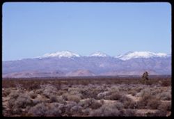
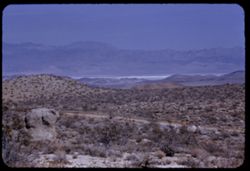
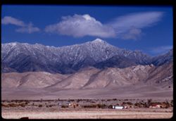
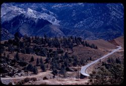
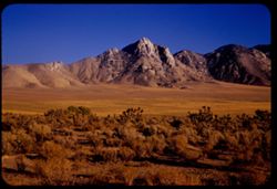
- Description:
- 100 f 9
- Subject:
- Deserts, Mojave Desert (Calif.), Mountains, Shrubs, Cactus, Tehachapi Mountains (Calif.), Clouds, Plains, and Snow
- Series:
- 3-69
- Creator:
- Cushman, Charles W., 1896-1972
- Date Created:
- 1969-03-21
- Genre:
- Landscape photographs
- Frame Number:
- 19
- Street Address:
- California State Highway 58
- County:
- Kern
- Abstract:
- Yellow fields Green hills Hwy 58
- Call Number:
- P15771
- Country:
- United States
- State/Province:
- California
- Alternate Identifier:
- 369.19
- Persistent URL:
- http://purl.dlib.indiana.edu/iudl/archives/cushman/P15771
- Holding Location:
- Bloomington - University Archives
Wells Library E460
1320 E 10th St.
Bloomington, IN 47405
Contact at archives@indiana.edu, 812-855-1127
-
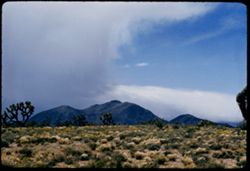
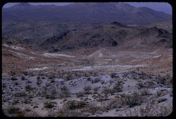
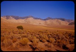
- Description:
- 100 f 9 TL
- Subject:
- Deserts, Mojave Desert (Calif.), Tehachapi Mountains (Calif.), Mountains, Shrubs, and Clouds
- Series:
- 3-69
- Creator:
- Cushman, Charles W., 1896-1972
- Date Created:
- 1969-03-21
- Genre:
- Landscape photographs
- Frame Number:
- 18
- Street Address:
- California State Highway 14
- County:
- Kern
- Abstract:
- Toward Tehachapi Mtns from Hwy 14
- Call Number:
- P15770
- City:
- Mojave
- Country:
- United States
- State/Province:
- California
- Alternate Identifier:
- 369.18
- Persistent URL:
- http://purl.dlib.indiana.edu/iudl/archives/cushman/P15770
- Holding Location:
- Bloomington - University Archives
Wells Library E460
1320 E 10th St.
Bloomington, IN 47405
Contact at archives@indiana.edu, 812-855-1127
-
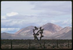
- Description:
- 100 f 9 TL
- Subject:
- Deserts, Mojave Desert (Calif.), Tehachapi Mountains (Calif.), Cactus, Mountains, Fences, Shrubs, and Clouds
- Series:
- 3-69
- Creator:
- Cushman, Charles W., 1896-1972
- Date Created:
- 1969-03-21
- Genre:
- Landscape photographs
- Frame Number:
- 17
- Street Address:
- California State Highway 14
- County:
- Kern
- Abstract:
- Toward Tehachapi Mtns from Hwy 14
- Call Number:
- P15769
- City:
- Mojave
- Country:
- United States
- State/Province:
- California
- Alternate Identifier:
- 369.17
- Persistent URL:
- http://purl.dlib.indiana.edu/iudl/archives/cushman/P15769
- Holding Location:
- Bloomington - University Archives
Wells Library E460
1320 E 10th St.
Bloomington, IN 47405
Contact at archives@indiana.edu, 812-855-1127
-
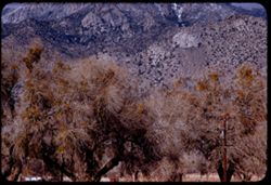
- Description:
- 100 f 9 TL
- Subject:
- Trees, Mountains, Shrubs, and Hills
- Series:
- 2-69
- Creator:
- Cushman, Charles W., 1896-1972
- Date Created:
- 1969-03-14
- Genre:
- Landscape photographs
- Frame Number:
- 15
- Street Address:
- California State Highway 14
- County:
- Kern
- Abstract:
- Views NW from Hwy 14 south of Mojave
- Call Number:
- P15732
- City:
- Mojave
- Country:
- United States
- State/Province:
- California
- Alternate Identifier:
- 269.15
- Persistent URL:
- http://purl.dlib.indiana.edu/iudl/archives/cushman/P15732
- Holding Location:
- Bloomington - University Archives
Wells Library E460
1320 E 10th St.
Bloomington, IN 47405
Contact at archives@indiana.edu, 812-855-1127
-
- Description:
- 100 f 9 TL
- Subject:
- Snow, Trees, Plains, Mountains, Shrubs, and Hills
- Series:
- 2-69
- Creator:
- Cushman, Charles W., 1896-1972
- Date Created:
- 1969-03-14
- Genre:
- Landscape photographs
- Frame Number:
- 14
- County:
- Kern
- Abstract:
- Views NW from Hwy 14 south of Mojave
- Call Number:
- P15731
- City:
- Mojave
- Country:
- United States
- State/Province:
- California
- Alternate Identifier:
- 269.14
- Persistent URL:
- http://purl.dlib.indiana.edu/iudl/archives/cushman/P15731
- Holding Location:
- Bloomington - University Archives
Wells Library E460
1320 E 10th St.
Bloomington, IN 47405
Contact at archives@indiana.edu, 812-855-1127
-
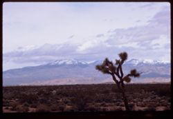
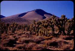
- Description:
- 100 f 8 tl
- Subject:
- Deserts, Mojave Desert (Calif.), Joshua trees, Plains, Mountains, Shrubs, and Clouds
- Series:
- 7-57
- Creator:
- Cushman, Charles W., 1896-1972
- Date Created:
- 1957-05-14
- Genre:
- Landscape photographs
- Frame Number:
- 15
- Street Address:
- United States Highway 6
- County:
- Kern
- Abstract:
- Mountains NW of US 6 north of Rosamond
- Call Number:
- P09294
- City:
- Rosamond
- Country:
- United States
- State/Province:
- California
- Alternate Identifier:
- 757.15
- Persistent URL:
- http://purl.dlib.indiana.edu/iudl/archives/cushman/P09294
- Holding Location:
- Bloomington - University Archives
Wells Library E460
1320 E 10th St.
Bloomington, IN 47405
Contact at archives@indiana.edu, 812-855-1127
-
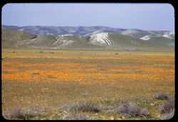
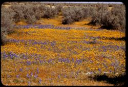
- Description:
- 100 f 5.6 tl
- Subject:
- Wildflowers, Valleys, Poppies, Sand, Temblor Range (Calif.), Mountains, Shrubs, and Hills
- Series:
- 12-55
- Creator:
- Cushman, Charles W., 1896-1972
- Date Created:
- 1955-03-25
- Genre:
- Landscape photographs
- Frame Number:
- 23
- Street Address:
- California State Highway 33 and United States Highway 466
- County:
- Kern
- Abstract:
- Field of poppies & sand hills to west - along US 466 west of Cal 33
- Call Number:
- P07919
- City:
- Blackwells Corner
- Country:
- United States
- State/Province:
- California
- Alternate Identifier:
- 1255.23
- Persistent URL:
- http://purl.dlib.indiana.edu/iudl/archives/cushman/P07919
- Holding Location:
- Bloomington - University Archives
Wells Library E460
1320 E 10th St.
Bloomington, IN 47405
Contact at archives@indiana.edu, 812-855-1127
-
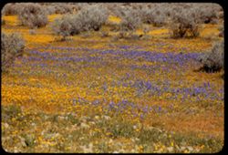
- Description:
- 100 f 5.6 tl 60'
- Subject:
- Wildflowers, Herbs, Shrubs, and Lupines
- Series:
- 12-55
- Creator:
- Cushman, Charles W., 1896-1972
- Date Created:
- 1955-03-25
- Genre:
- Identification photographs
- Frame Number:
- 21
- Street Address:
- United States Highway 466
- County:
- Kern
- Abstract:
- Lupine & yellow
- Call Number:
- P07917
- City:
- Wasco
- Country:
- United States
- State/Province:
- California
- Alternate Identifier:
- 1255.21
- Persistent URL:
- http://purl.dlib.indiana.edu/iudl/archives/cushman/P07917
- Holding Location:
- Bloomington - University Archives
Wells Library E460
1320 E 10th St.
Bloomington, IN 47405
Contact at archives@indiana.edu, 812-855-1127
-
- Description:
- 100 f 5.6 tl 40'
- Subject:
- Shrubs, Herbs, Wildflowers, and Lupines
- Series:
- 12-55
- Creator:
- Cushman, Charles W., 1896-1972
- Date Created:
- 1955-03-25
- Genre:
- Identification photographs
- Frame Number:
- 20
- Street Address:
- United States Highway 466
- County:
- Kern
- Abstract:
- Lupine and yellow flowers
- Call Number:
- P07916
- City:
- Wasco
- Country:
- United States
- State/Province:
- California
- Alternate Identifier:
- 1255.20
- Persistent URL:
- http://purl.dlib.indiana.edu/iudl/archives/cushman/P07916
- Holding Location:
- Bloomington - University Archives
Wells Library E460
1320 E 10th St.
Bloomington, IN 47405
Contact at archives@indiana.edu, 812-855-1127
-
- Description:
- 100 f 4.5 tl
- Subject:
- Tehachapi Mountains (Calif.), Trails & paths, Trees, Mountains, Shrubs, Railroads, Southern Pacific Railroad Company, and Tunnels
- Series:
- 12-55
- Creator:
- Cushman, Charles W., 1896-1972
- Date Created:
- 1955-03-24
- Genre:
- Views
- Frame Number:
- 19
- County:
- Kern
- Abstract:
- So Pac freight, up bound, emerges from tunnel
- Call Number:
- P07915
- City:
- Keene
- Country:
- United States
- State/Province:
- California
- Alternate Identifier:
- 1255.19
- Persistent URL:
- http://purl.dlib.indiana.edu/iudl/archives/cushman/P07915
- Holding Location:
- Bloomington - University Archives
Wells Library E460
1320 E 10th St.
Bloomington, IN 47405
Contact at archives@indiana.edu, 812-855-1127
-
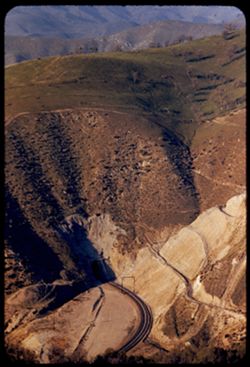
- Description:
- 100 f 4.5 tl
- Subject:
- Rocks, Roads, Tehachapi Mountains (Calif.), Trails & paths, Trees, Mountains, Shrubs, Railroad tracks, Utility poles, and Southern Pacific Railroad Company
- Series:
- 12-55
- Creator:
- Cushman, Charles W., 1896-1972
- Date Created:
- 1955-03-24
- Genre:
- Landscape photographs
- Frame Number:
- 18
- County:
- Kern
- Abstract:
- S P curves, [cut] and tunnel mouth from same vantage point
- Call Number:
- P07914
- City:
- Keene
- Country:
- United States
- State/Province:
- California
- Alternate Identifier:
- 1255.18
- Persistent URL:
- http://purl.dlib.indiana.edu/iudl/archives/cushman/P07914
- Holding Location:
- Bloomington - University Archives
Wells Library E460
1320 E 10th St.
Bloomington, IN 47405
Contact at archives@indiana.edu, 812-855-1127
-
- Description:
- 100 f 4.5 tl
- Subject:
- Roads, Tehachapi Mountains (Calif.), Southern Pacific Tunnel, Trees, Mountains, Tunnels, Railroad tracks, Hills, Utility poles, and Shrubs
- Series:
- 12-55
- Creator:
- Cushman, Charles W., 1896-1972
- Date Created:
- 1955-03-24
- Genre:
- Landscape photographs
- Frame Number:
- 17
- Street Address:
- United States Highway 466
- County:
- Kern
- Abstract:
- S P curves, [cut] and tunnel mouth from same vantage point
- Call Number:
- P07913
- City:
- Keene
- Country:
- United States
- State/Province:
- California
- Alternate Identifier:
- 1255.17
- Persistent URL:
- http://purl.dlib.indiana.edu/iudl/archives/cushman/P07913
- Holding Location:
- Bloomington - University Archives
Wells Library E460
1320 E 10th St.
Bloomington, IN 47405
Contact at archives@indiana.edu, 812-855-1127
-
- Description:
- 100 f 5.6 tl
- Subject:
- Trails & paths, Mountains, Trees, Utility poles, Railroad tracks, Tunnels, Tehachapi Mountains (Calif.), Shrubs, and Southern Pacific Tunnel
- Series:
- 12-55
- Creator:
- Cushman, Charles W., 1896-1972
- Date Created:
- 1955-03-24
- Genre:
- Views
- Frame Number:
- 16
- Street Address:
- United States Highway 466
- County:
- Kern
- Abstract:
- S P below Hwy 466 west of Keene a few miles
- Call Number:
- P07912
- City:
- Keene
- Country:
- United States
- State/Province:
- California
- Alternate Identifier:
- 1255.16
- Persistent URL:
- http://purl.dlib.indiana.edu/iudl/archives/cushman/P07912
- Holding Location:
- Bloomington - University Archives
Wells Library E460
1320 E 10th St.
Bloomington, IN 47405
Contact at archives@indiana.edu, 812-855-1127
-
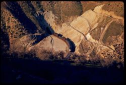
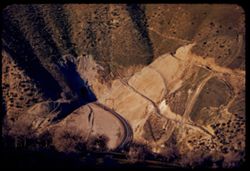
- Description:
- 100 f 5.6 tl
- Subject:
- Rocks, Tehachapi Mountains (Calif.), Trees, Mountains, Shrubs, South Pacific Loop, Utility poles, Railroads, and Southern Pacific Railroad Company
- Series:
- 12-55
- Creator:
- Cushman, Charles W., 1896-1972
- Date Created:
- 1955-03-24
- Genre:
- Landscape photographs
- Frame Number:
- 15
- County:
- Kern
- Persons Pictured:
- Hood, William
- Abstract:
- Mountain above famous Sou. Pac. loop in the Tehachapi built in 1876 by Wm Hood
- Call Number:
- P07911
- Country:
- United States
- State/Province:
- California
- Alternate Identifier:
- 1255.15
- Persistent URL:
- http://purl.dlib.indiana.edu/iudl/archives/cushman/P07911
- Holding Location:
- Bloomington - University Archives
Wells Library E460
1320 E 10th St.
Bloomington, IN 47405
Contact at archives@indiana.edu, 812-855-1127
-
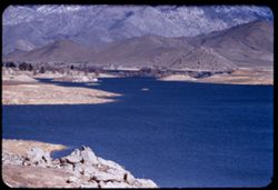
- Description:
- 100 f 8 tl
- Subject:
- Mojave Desert (Calif.), Valleys, Flowers, Mountains, Shrubs, Sierra Nevada (Calif. and Nev.), Hills, Indian Wells Valley (Calif.), and Utility poles
- Series:
- 7-55
- Creator:
- Cushman, Charles W., 1896-1972
- Date Created:
- 1955-03-21
- Genre:
- Landscape photographs
- Frame Number:
- 28
- Street Address:
- Randsburg Road and Trona Road
- County:
- Kern
- Abstract:
- West from just above junction - view across Indiana Wells Valley toward Inyokern and Sierra beyond
- Call Number:
- P07752
- City:
- Inyokern
- Country:
- United States
- State/Province:
- California
- Alternate Identifier:
- 755.28
- Persistent URL:
- http://purl.dlib.indiana.edu/iudl/archives/cushman/P07752
- Holding Location:
- Bloomington - University Archives
Wells Library E460
1320 E 10th St.
Bloomington, IN 47405
Contact at archives@indiana.edu, 812-855-1127
-
- Description:
- 100 f 8 tl
- Subject:
- Mojave Desert (Calif.), Valleys, Trails & paths, Argus Range (Calif.), Mountains, Shrubs, Lakes & ponds, Hills, and Fog
- Series:
- 7-55
- Creator:
- Cushman, Charles W., 1896-1972
- Date Created:
- 1955-03-21
- Genre:
- Landscape photographs
- Frame Number:
- 27
- Street Address:
- Inyokern Road and Trona Road
- County:
- Kern and San Bernardino
- Abstract:
- View north across valley from 3 miles south of junction with Inyokern - Trona rd.
- Call Number:
- P07751
- City:
- China Lake
- Country:
- United States
- State/Province:
- California
- Alternate Identifier:
- 755.27
- Persistent URL:
- http://purl.dlib.indiana.edu/iudl/archives/cushman/P07751
- Holding Location:
- Bloomington - University Archives
Wells Library E460
1320 E 10th St.
Bloomington, IN 47405
Contact at archives@indiana.edu, 812-855-1127
-
- Description:
- 100 f 8 tl
- Subject:
- Rocks, Valleys, Dirt roads, Argus Range (Calif.), Mountains, Shrubs, and Hills
- Series:
- 7-55
- Creator:
- Cushman, Charles W., 1896-1972
- Date Created:
- 1955-03-21
- Genre:
- Landscape photographs
- Frame Number:
- 23
- Street Address:
- Johannesburg Road and Trona Road
- County:
- Kern and San Bernardino
- Abstract:
- NNE toward China Lake and Argus Mtns from top of Johannesburg - Trona road about midway
- Call Number:
- P07747
- City:
- China Lake
- Country:
- United States
- State/Province:
- California
- Alternate Identifier:
- 755.23
- Persistent URL:
- http://purl.dlib.indiana.edu/iudl/archives/cushman/P07747
- Holding Location:
- Bloomington - University Archives
Wells Library E460
1320 E 10th St.
Bloomington, IN 47405
Contact at archives@indiana.edu, 812-855-1127
-
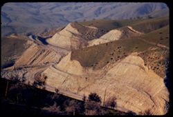
- Description:
- 100 f 8 tl
- Subject:
- Valleys, Roads, Mountains, Shrubs, and Hills
- Series:
- 7-55
- Creator:
- Cushman, Charles W., 1896-1972
- Date Created:
- 1955-03-21
- Genre:
- Landscape photographs
- Frame Number:
- 22
- Street Address:
- Johannesburg Road and Trona Road
- County:
- Kern and San Bernardino
- Abstract:
- Bad Lands west of J - T road
- Call Number:
- P07746
- City:
- Randsburg
- Country:
- United States
- State/Province:
- California
- Alternate Identifier:
- 755.22
- Persistent URL:
- http://purl.dlib.indiana.edu/iudl/archives/cushman/P07746
- Holding Location:
- Bloomington - University Archives
Wells Library E460
1320 E 10th St.
Bloomington, IN 47405
Contact at archives@indiana.edu, 812-855-1127
-
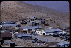
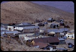
- Description:
- 100 f 6.3 tl
- Subject:
- Valleys, Hills, Roads, Utility poles, Electric lines, Stores & shops, Buildings, Vehicles, Signs (Notices), Automobile service stations, and Shrubs
- Series:
- 7-55
- Creator:
- Cushman, Charles W., 1896-1972
- Date Created:
- 1955-03-21
- Genre:
- Cityscape photographs
- Frame Number:
- 19
- County:
- Kern
- Abstract:
- East part of Randsburg from near bus section
- Call Number:
- P07743
- City:
- Randsburg
- Country:
- United States
- State/Province:
- California
- Alternate Identifier:
- 755.19
- Persistent URL:
- http://purl.dlib.indiana.edu/iudl/archives/cushman/P07743
- Holding Location:
- Bloomington - University Archives
Wells Library E460
1320 E 10th St.
Bloomington, IN 47405
Contact at archives@indiana.edu, 812-855-1127
-
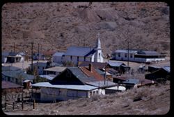
- Description:
- 100 f 5.6 tl
- Subject:
- Crosses, Electric lines, Dirt roads, Buildings, Clotheslines, Dwellings, Hills, Utility poles, Churches, and Shrubs
- Series:
- 7-55
- Creator:
- Cushman, Charles W., 1896-1972
- Date Created:
- 1955-03-21
- Genre:
- Cityscape photographs
- Frame Number:
- 18
- Street Address:
- School Heights
- County:
- Kern
- Abstract:
- East part of Randsburg from School Heights
- Call Number:
- P07742
- City:
- Randsburg
- Country:
- United States
- State/Province:
- California
- Alternate Identifier:
- 755.18
- Persistent URL:
- http://purl.dlib.indiana.edu/iudl/archives/cushman/P07742
- Holding Location:
- Bloomington - University Archives
Wells Library E460
1320 E 10th St.
Bloomington, IN 47405
Contact at archives@indiana.edu, 812-855-1127
-
- Description:
- 100 f 6.3 tl
- Subject:
- Stores & shops, Valleys, Electric lines, Roads, School House Hill, Automobile service stations, Buildings, Shrubs, Vehicles, Hills, Utility poles, Signs ...
- Series:
- 7-55
- Creator:
- Cushman, Charles W., 1896-1972
- Date Created:
- 1955-03-21
- Genre:
- Cityscape photographs
- Frame Number:
- 17
- County:
- Kern
- Abstract:
- Looking down on business section of Randsburg from hts. of school
- Call Number:
- P07741
- City:
- Randsburg
- Country:
- United States
- State/Province:
- California
- Alternate Identifier:
- 755.17
- Persistent URL:
- http://purl.dlib.indiana.edu/iudl/archives/cushman/P07741
- Holding Location:
- Bloomington - University Archives
Wells Library E460
1320 E 10th St.
Bloomington, IN 47405
Contact at archives@indiana.edu, 812-855-1127
-
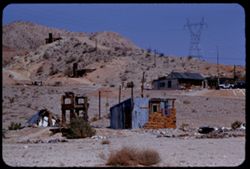
- Description:
- 100 f 8 - tl
- Subject:
- Rocks, Electric lines, Dirt roads, Automobiles, Wagon Wheel Mountain (Calif.), Mountains, Shrubs, Dwellings, Utility poles, Jawbone Canyon (Calif.), and Minard
- Series:
- 7-55
- Creator:
- Cushman, Charles W., 1896-1972
- Date Created:
- 1955-03-21
- Genre:
- Landscape photographs
- Frame Number:
- 16
- Street Address:
- United States Highway 6 and Randsburg Road
- County:
- Kern
- Abstract:
- Minard's - along US 6 at same pt. 2 mi. so. of Randsburg rd.
- Call Number:
- P07740
- Country:
- United States
- State/Province:
- California
- Alternate Identifier:
- 755.16
- Persistent URL:
- http://purl.dlib.indiana.edu/iudl/archives/cushman/P07740
- Holding Location:
- Bloomington - University Archives
Wells Library E460
1320 E 10th St.
Bloomington, IN 47405
Contact at archives@indiana.edu, 812-855-1127
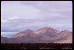
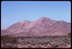
-
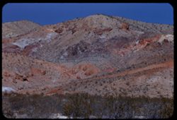
- Description:
- 100 f 8 tl
- Subject:
- Rocks, Electric lines, Wagon Wheel Mountain (Calif.), Mountains, Shrubs, Sierra Nevada (Calif. and Nev.), Hills, Red Hill (Kern County, Calif.), and Jawbone ...
- Series:
- 7-55
- Creator:
- Cushman, Charles W., 1896-1972
- Date Created:
- 1955-03-21
- Genre:
- Landscape photographs
- Frame Number:
- 15
- Street Address:
- United States Highway 6 and Randsburg Road
- County:
- Kern
- Abstract:
- Colorful mtns along US 6 2 mi. south of Wagon Wheel at turn off to Randsburg west of Red Hill
- Call Number:
- P07739
- Country:
- United States
- State/Province:
- California
- Alternate Identifier:
- 755.15
- Persistent URL:
- http://purl.dlib.indiana.edu/iudl/archives/cushman/P07739
- Holding Location:
- Bloomington - University Archives
Wells Library E460
1320 E 10th St.
Bloomington, IN 47405
Contact at archives@indiana.edu, 812-855-1127
-
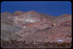
- Description:
- 100 f 8 tl
- Subject:
- Red Hill (Kern County, Calif.), Hills, Mountains, Shrubs, Sierra Nevada (Calif. and Nev.), Rocks, Jawbone Canyon (Calif.), Wagon Wheel Mountain (Calif.), and...
- Series:
- 7-55
- Creator:
- Cushman, Charles W., 1896-1972
- Date Created:
- 1955-03-21
- Genre:
- Landscape photographs
- Frame Number:
- 14
- Street Address:
- Randsburg Road and United States Highway 6
- County:
- Kern
- Abstract:
- Colorful mtns along US 6 2 mi. south of Wagon Wheel at turn off to Randsburg west of Red Hill
- Call Number:
- P07738
- Country:
- United States
- State/Province:
- California
- Alternate Identifier:
- 755.14
- Persistent URL:
- http://purl.dlib.indiana.edu/iudl/archives/cushman/P07738
- Holding Location:
- Bloomington - University Archives
Wells Library E460
1320 E 10th St.
Bloomington, IN 47405
Contact at archives@indiana.edu, 812-855-1127
-
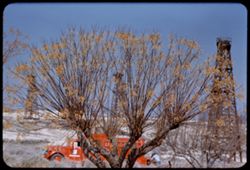
- Description:
- 100 f 5.4
- Subject:
- Petroleum workers, Midway Oil Camp (Calif.), Trees, Oil well drilling rigs, Shrubs, Roads, Trucks, Chinaberry trees, and Oil wells
- Series:
- 4-55
- Creator:
- Cushman, Charles W., 1896-1972
- Date Created:
- 1955-03-01
- Genre:
- Identification photographs
- Frame Number:
- 25
- County:
- Kern
- Abstract:
- Chinaberry & oil truck North of Fellows in Midway Field Kern County
- Call Number:
- P07652
- City:
- Fellows
- Country:
- United States
- State/Province:
- California
- Alternate Identifier:
- 455.25
- Persistent URL:
- http://purl.dlib.indiana.edu/iudl/archives/cushman/P07652
- Holding Location:
- Bloomington - University Archives
Wells Library E460
1320 E 10th St.
Bloomington, IN 47405
Contact at archives@indiana.edu, 812-855-1127
-
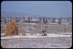
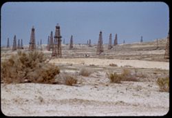
- Description:
- 100 f 5.2
- Subject:
- Oil well drilling rigs, Roads, Trees, Mountains, Shrubs, Facilities, Midway Oil Camp (Calif.), Utility poles, and Oil wells
- Series:
- 4-55
- Creator:
- Cushman, Charles W., 1896-1972
- Date Created:
- 1955-03-01
- Genre:
- Views
- Frame Number:
- 24
- County:
- Kern
- Abstract:
- Distant derrick forest north of Fellows
- Call Number:
- P07651
- City:
- Fellows
- Country:
- United States
- State/Province:
- California
- Alternate Identifier:
- 455.24
- Persistent URL:
- http://purl.dlib.indiana.edu/iudl/archives/cushman/P07651
- Holding Location:
- Bloomington - University Archives
Wells Library E460
1320 E 10th St.
Bloomington, IN 47405
Contact at archives@indiana.edu, 812-855-1127
-
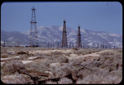
- Description:
- 100 f 5.6 tl
- Subject:
- Valleys, Facilities, Hills, Mountains, Storage tanks, Oil wells, Temblor Range (Calif.), Electric lines, Shrubs, Roads, and Utility poles
- Series:
- 4-55
- Creator:
- Cushman, Charles W., 1896-1972
- Date Created:
- 1955-03-01
- Genre:
- Views
- Frame Number:
- 23
- County:
- Kern
- Abstract:
- View west from Fellows
- Call Number:
- P07650
- City:
- Fellows
- Country:
- United States
- State/Province:
- California
- Alternate Identifier:
- 455.23
- Persistent URL:
- http://purl.dlib.indiana.edu/iudl/archives/cushman/P07650
- Holding Location:
- Bloomington - University Archives
Wells Library E460
1320 E 10th St.
Bloomington, IN 47405
Contact at archives@indiana.edu, 812-855-1127
-
- Description:
- 100 f 5.6 tl
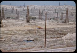
- Subject:
- Oil wells, Storage tanks, Hills, Mountains, Dirt roads, Shrubs, Oil well drilling rigs, and Facilities
- Series:
- 4-55
- Creator:
- Cushman, Charles W., 1896-1972
- Date Created:
- 1955-03-01
- Genre:
- Views
- Frame Number:
- 22
- County:
- Kern
- Abstract:
- 3 derricks with folded hills in background (Hazy)
- Call Number:
- P07649
- City:
- Taft
- Country:
- United States
- State/Province:
- California
- Alternate Identifier:
- 455.22
- Persistent URL:
- http://purl.dlib.indiana.edu/iudl/archives/cushman/P07649
- Holding Location:
- Bloomington - University Archives
Wells Library E460
1320 E 10th St.
Bloomington, IN 47405
Contact at archives@indiana.edu, 812-855-1127
-
- Description:
- 100 f 5.3 tl
- Subject:
- Oil wells, Trucks, Hills, Bodies of water, Roads, Shrubs, Trees, Oil well drilling rigs, Facilities, Pipes (Conduits), Utility poles, and Petroleum workers
- Series:
- 4-55
- Creator:
- Cushman, Charles W., 1896-1972
- Date Created:
- 1955-03-01
- Genre:
- Views
- Frame Number:
- 21
- County:
- Kern
- Abstract:
- Oil derricks north of Ford City
- Call Number:
- P07648
- City:
- Ford City and Taft
- Country:
- United States
- State/Province:
- California
- Alternate Identifier:
- 455.21
- Persistent URL:
- http://purl.dlib.indiana.edu/iudl/archives/cushman/P07648
- Holding Location:
- Bloomington - University Archives
Wells Library E460
1320 E 10th St.
Bloomington, IN 47405
Contact at archives@indiana.edu, 812-855-1127
-
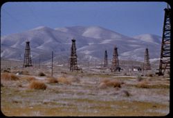
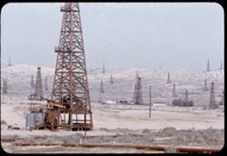
- Description:
- 100 f 5.6
- Subject:
- Oil well drilling rigs, Storage tanks, Shrubs, Elk Hills (Calif.), Hills, and Oil wells
- Series:
- 4-55
- Creator:
- Cushman, Charles W., 1896-1972
- Date Created:
- 1955-03-01
- Genre:
- Views
- Frame Number:
- 19
- County:
- Kern
- Abstract:
- Derrick forest - Elk hills north of Taft
- Call Number:
- P07646
- City:
- Taft
- Country:
- United States
- State/Province:
- California
- Alternate Identifier:
- 455.19
- Persistent URL:
- http://purl.dlib.indiana.edu/iudl/archives/cushman/P07646
- Holding Location:
- Bloomington - University Archives
Wells Library E460
1320 E 10th St.
Bloomington, IN 47405
Contact at archives@indiana.edu, 812-855-1127
-
- Description:
- 50 f 8
- Subject:
- Oil wells, Hills, Shrubs, Trees, Buildings, Oil well drilling rigs, Facilities, Pipes (Conduits), and Utility poles
- Series:
- 4-55
- Creator:
- Cushman, Charles W., 1896-1972
- Date Created:
- 1955-03-01
- Genre:
- Views
- Frame Number:
- 20
- County:
- Kern
- Abstract:
- Oil derricks north of Ford City
- Call Number:
- P07647
- City:
- Ford City and Taft
- Country:
- United States
- State/Province:
- California
- Alternate Identifier:
- 455.20
- Persistent URL:
- http://purl.dlib.indiana.edu/iudl/archives/cushman/P07647
- Holding Location:
- Bloomington - University Archives
Wells Library E460
1320 E 10th St.
Bloomington, IN 47405
Contact at archives@indiana.edu, 812-855-1127
-
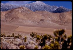
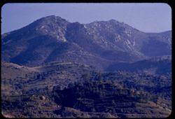
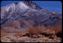
- Description:
- 100 f 7
- Subject:
- Joshua trees, Croplands, Hills, Lamont Peak (Calif.), Forests, Mountains, Shrubs, Owens Peak (Calif.), Trees, Rocks, Plants, Clouds, Walker Pass (Calif.), Fe...
- Series:
- 2-55
- Creator:
- Cushman, Charles W., 1896-1972
- Date Created:
- 1955-02-26
- Genre:
- Landscape photographs
- Frame Number:
- 21
- Street Address:
- California State Highway 178
- County:
- Kern
- Abstract:
- Same high peak* seen across Joshua forest *Lamont Pk 7468 ft. or Owens Pk 8475 ft.
- Call Number:
- P07579
- Country:
- United States
- State/Province:
- California
- Alternate Identifier:
- 255.21
- Persistent URL:
- http://purl.dlib.indiana.edu/iudl/archives/cushman/P07579
- Holding Location:
- Bloomington - University Archives
Wells Library E460
1320 E 10th St.
Bloomington, IN 47405
Contact at archives@indiana.edu, 812-855-1127
-
A high Sierra (prob. Owens Pk.8475 ft.) seen from Cal. 178 about ten miles N.W. of Walker Pass EK CL
- Description:
- 100 f 7 tl
- Subject:
- Snow, Roads, Owens Peak (Calif.), Trees, Walker Pass (Calif.), Signs (Notices), Mountains, Shrubs, Clouds, Vehicles, Sierra Nevada (Calif. and Nev.), Dwellin...
- Series:
- 2-55
- Creator:
- Cushman, Charles W., 1896-1972
- Date Created:
- 1955-02-26
- Genre:
- Landscape photographs
- Frame Number:
- 20
- Street Address:
- California State Highway 178
- County:
- Kern
- Abstract:
- A high Sierra* from ten miles West of Walker Pass *Lamont Pk 7468 ft. or Owens Pk 8475 ft.
- Call Number:
- P07578
- Country:
- United States
- State/Province:
- California
- Alternate Identifier:
- 255.20
- Persistent URL:
- http://purl.dlib.indiana.edu/iudl/archives/cushman/P07578
- Holding Location:
- Bloomington - University Archives
Wells Library E460
1320 E 10th St.
Bloomington, IN 47405
Contact at archives@indiana.edu, 812-855-1127
-
- Description:
- 100 f 6.3 tl
- Subject:
- Rocks, Trees, Walker Pass (Calif.), Mountains, Shrubs, Cottonwood, Mistletoe, Forests, and Utility poles
- Series:
- 2-55
- Creator:
- Cushman, Charles W., 1896-1972
- Date Created:
- 1955-02-26
- Genre:
- Identification photographs
- Frame Number:
- 19
- Street Address:
- California State Highway 178
- County:
- Kern
- Abstract:
- from 20 mi. w. of Walker Pass
- Call Number:
- P07577
- Country:
- United States
- State/Province:
- California
- Alternate Identifier:
- 255.19
- Persistent URL:
- http://purl.dlib.indiana.edu/iudl/archives/cushman/P07577
- Holding Location:
- Bloomington - University Archives
Wells Library E460
1320 E 10th St.
Bloomington, IN 47405
Contact at archives@indiana.edu, 812-855-1127
-
- Description:
- 100 f 6.3 tl
- Subject:
- Snow, Trees, Mountains, Shrubs, Hills, and Rocks
- Series:
- 2-55
- Creator:
- Cushman, Charles W., 1896-1972
- Date Created:
- 1955-02-26
- Genre:
- Landscape photographs
- Frame Number:
- 18
- County:
- Kern
- Abstract:
- Mtn wall frosted north slope between Isabella & Weldon
- Call Number:
- P07576
- City:
- Lake Isabella and Weldon
- Country:
- United States
- State/Province:
- California
- Alternate Identifier:
- 255.18
- Persistent URL:
- http://purl.dlib.indiana.edu/iudl/archives/cushman/P07576
- Holding Location:
- Bloomington - University Archives
Wells Library E460
1320 E 10th St.
Bloomington, IN 47405
Contact at archives@indiana.edu, 812-855-1127
-
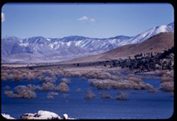
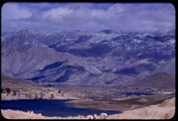
- Description:
- 100 f 4.5 tl
- Subject:
- Rocks, Reservoirs, Trees, Isabella Lake (Calif. : Lake), Mountains, Shrubs, Lakes & ponds, Clouds, and Hills
- Series:
- 2-55
- Creator:
- Cushman, Charles W., 1896-1972
- Date Created:
- 1955-02-26
- Genre:
- Landscape photographs
- Frame Number:
- 17
- County:
- Kern
- Abstract:
- Tops of trees in Isabella reservoir
- Call Number:
- P07575
- City:
- Lake Isabella
- Country:
- United States
- State/Province:
- California
- Alternate Identifier:
- 255.17
- Persistent URL:
- http://purl.dlib.indiana.edu/iudl/archives/cushman/P07575
- Holding Location:
- Bloomington - University Archives
Wells Library E460
1320 E 10th St.
Bloomington, IN 47405
Contact at archives@indiana.edu, 812-855-1127
-
- Description:
- 100 f 5.6 tl
- Subject:
- Isabella Lake (Calif. : Lake), Isabella Main Dam (Calif.), Roads, Bridges, Mountains, Dirt roads, Utility poles, Snow, Trees, Rocks, and Shrubs
- Series:
- 2-55
- Creator:
- Cushman, Charles W., 1896-1972
- Date Created:
- 1955-02-26
- Genre:
- Landscape photographs
- Frame Number:
- 16
- County:
- Kern
- Abstract:
- View S by E from Isabella dam
- Call Number:
- P07574
- Country:
- United States
- State/Province:
- California
- Alternate Identifier:
- 255.16
- Persistent URL:
- http://purl.dlib.indiana.edu/iudl/archives/cushman/P07574
- Holding Location:
- Bloomington - University Archives
Wells Library E460
1320 E 10th St.
Bloomington, IN 47405
Contact at archives@indiana.edu, 812-855-1127
-
- Description:
- 100 f 5.6
- Subject:
- Rocks, Reservoirs, Roads, Isabella Lake (Calif. : Lake), Mountains, Shrubs, Sierra Nevada (Calif. and Nev.), and Hills
- Series:
- 2-55
- Creator:
- Cushman, Charles W., 1896-1972
- Date Created:
- 1955-02-26
- Genre:
- Landscape photographs
- Frame Number:
- 15
- County:
- Kern
- Abstract:
- NE across Isabella Reservoir at noon
- Call Number:
- P07573
- Country:
- United States
- State/Province:
- California
- Alternate Identifier:
- 255.15
- Persistent URL:
- http://purl.dlib.indiana.edu/iudl/archives/cushman/P07573
- Holding Location:
- Bloomington - University Archives
Wells Library E460
1320 E 10th St.
Bloomington, IN 47405
Contact at archives@indiana.edu, 812-855-1127
-
- Description:
- 100 f 7 tl
- Subject:
- Rocks, Reservoirs, Isabella Main Dam (Calif.), Mountains, Shrubs, Clouds, Sierra Nevada (Calif. and Nev.), Hills, Snow, and Isabella Lake (Calif. : Lake)
- Series:
- 2-55
- Creator:
- Cushman, Charles W., 1896-1972
- Date Created:
- 1955-02-26
- Genre:
- Landscape photographs
- Frame Number:
- 13
- County:
- Kern
- Abstract:
- Sierra Angle of Isabella Dam
- Call Number:
- P07571
- Country:
- United States
- State/Province:
- California
- Alternate Identifier:
- 255.13
- Persistent URL:
- http://purl.dlib.indiana.edu/iudl/archives/cushman/P07571
- Holding Location:
- Bloomington - University Archives
Wells Library E460
1320 E 10th St.
Bloomington, IN 47405
Contact at archives@indiana.edu, 812-855-1127
-
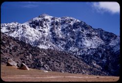
- Description:
- 100 f 5.6
- Subject:
- Rocks, Trees, Mountains, Shrubs, Clouds, Sierra Nevada (Calif. and Nev.), Cook Peak (Calif.), and Snow
- Series:
- 2-55
- Creator:
- Cushman, Charles W., 1896-1972
- Date Created:
- 1955-02-26
- Genre:
- Landscape photographs
- Frame Number:
- 12
- County:
- Kern
- Abstract:
- Snow capped mtn near Isabella Cook Pk. 5410 ft.
- Call Number:
- P07570
- City:
- Lake Isabella
- Country:
- United States
- State/Province:
- California
- Alternate Identifier:
- 255.12
- Persistent URL:
- http://purl.dlib.indiana.edu/iudl/archives/cushman/P07570
- Holding Location:
- Bloomington - University Archives
Wells Library E460
1320 E 10th St.
Bloomington, IN 47405
Contact at archives@indiana.edu, 812-855-1127
-
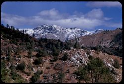
- Description:
- 100 f 6.3
- Subject:
- Snow, Kern River Valley (Calif.), Mountains, Shrubs, Clouds, Sierra Nevada (Calif. and Nev.), Hills, Cook Peak (Calif.), Rocks, and Trees
- Series:
- 2-55
- Creator:
- Cushman, Charles W., 1896-1972
- Date Created:
- 1955-02-26
- Genre:
- Landscape photographs
- Frame Number:
- 11
- Street Address:
- California State Highway 178
- County:
- Kern
- Abstract:
- Sierra Nevada Cook Peak from Kern Riv. Canyon (37 mi. east)
- Call Number:
- P07569
- City:
- Bakerfield
- Country:
- United States
- State/Province:
- California
- Alternate Identifier:
- 255.11
- Persistent URL:
- http://purl.dlib.indiana.edu/iudl/archives/cushman/P07569
- Holding Location:
- Bloomington - University Archives
Wells Library E460
1320 E 10th St.
Bloomington, IN 47405
Contact at archives@indiana.edu, 812-855-1127
-
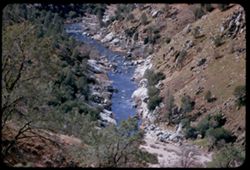
- Subject:
- Rocks, Valleys, Kern River Valley (Calif.), Shrubs, Kern River (Calif.), Hills, Rivers, and Trees
- Series:
- 2-55
- Creator:
- Cushman, Charles W., 1896-1972
- Date Created:
- 1955-02-26
- Genre:
- Views
- Frame Number:
- 10
- County:
- Kern
- Abstract:
- View down Kern river
- Call Number:
- P07568
- Country:
- United States
- State/Province:
- California
- Alternate Identifier:
- 255.10
- Persistent URL:
- http://purl.dlib.indiana.edu/iudl/archives/cushman/P07568
- Holding Location:
- Bloomington - University Archives
Wells Library E460
1320 E 10th St.
Bloomington, IN 47405
Contact at archives@indiana.edu, 812-855-1127
-
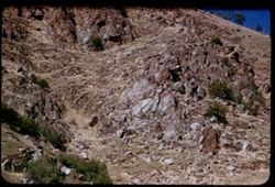
- Description:
- 100 f 5.6
- Subject:
- Kern River Valley (Calif.), Hills, Shrubs, Trees, Rocks, and Rock formations
- Series:
- 2-55
- Creator:
- Cushman, Charles W., 1896-1972
- Date Created:
- 1955-02-26
- Genre:
- Landscape photographs
- Frame Number:
- 9
- County:
- Kern
- Abstract:
- High up on right bank
- Call Number:
- P07567
- Country:
- United States
- State/Province:
- California
- Alternate Identifier:
- 255.9
- Persistent URL:
- http://purl.dlib.indiana.edu/iudl/archives/cushman/P07567
- Holding Location:
- Bloomington - University Archives
Wells Library E460
1320 E 10th St.
Bloomington, IN 47405
Contact at archives@indiana.edu, 812-855-1127
-
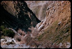
- Description:
- 100 f 5.6
- Subject:
- Canyons, Shrubs, Trees, Rocks, and Kern River Valley (Calif.)
- Series:
- 2-55
- Creator:
- Cushman, Charles W., 1896-1972
- Date Created:
- 1955-02-26
- Genre:
- Views
- Frame Number:
- 6
- Street Address:
- California State Highway 178
- County:
- Kern
- Abstract:
- View down canyon
- Call Number:
- P07564
- City:
- Bakersfield
- Country:
- United States
- State/Province:
- California
- Alternate Identifier:
- 255.6
- Persistent URL:
- http://purl.dlib.indiana.edu/iudl/archives/cushman/P07564
- Holding Location:
- Bloomington - University Archives
Wells Library E460
1320 E 10th St.
Bloomington, IN 47405
Contact at archives@indiana.edu, 812-855-1127
-
- Description:
- 50 f 11
- Subject:
- Deserts, Trees, Walker Pass (Calif.), Scodie Mountains (Calif.), Mountains, and Shrubs
- Series:
- 12-54
- Creator:
- Cushman, Charles W., 1896-1972
- Date Created:
- 1954-09-18
- Genre:
- Landscape photographs
- Frame Number:
- 33
- Street Address:
- California State Highway 178 and Walker Pass Road
- County:
- Kern
- Abstract:
- Two view \ Kiavah Mtns eastward from low part of Walker Pass Rd.
- Call Number:
- P07423
- Country:
- United States
- State/Province:
- California
- Alternate Identifier:
- 1254.33
- Persistent URL:
- http://purl.dlib.indiana.edu/iudl/archives/cushman/P07423
- Holding Location:
- Bloomington - University Archives
Wells Library E460
1320 E 10th St.
Bloomington, IN 47405
Contact at archives@indiana.edu, 812-855-1127
-
- Description:
- 50 f 11
- Subject:
- Deserts, Trees, Walker Pass (Calif.), Scodie Mountains (Calif.), Mountains, and Shrubs
- Series:
- 12-54
- Creator:
- Cushman, Charles W., 1896-1972
- Date Created:
- 1954-09-18
- Genre:
- Landscape photographs
- Frame Number:
- 34
- Street Address:
- California State Highway 178 and Walker Pass Road
- County:
- Kern
- Abstract:
- Two view \ Kiavah Mtns eastward from low part of Walker Pass Rd.
- Call Number:
- P07424
- Country:
- United States
- State/Province:
- California
- Alternate Identifier:
- 1254.34
- Persistent URL:
- http://purl.dlib.indiana.edu/iudl/archives/cushman/P07424
- Holding Location:
- Bloomington - University Archives
Wells Library E460
1320 E 10th St.
Bloomington, IN 47405
Contact at archives@indiana.edu, 812-855-1127
-
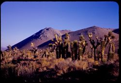
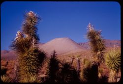
- Description:
- 50 f 8
- Subject:
- Deserts, Mojave Desert (Calif.), Joshua trees, Shrubs, and Hills
- Series:
- 12-54
- Creator:
- Cushman, Charles W., 1896-1972
- Date Created:
- 1954-09-18
- Genre:
- Landscape photographs
- Frame Number:
- 32
- Street Address:
- California State Highway 178 and Walker Pass Road
- County:
- Kern
- Abstract:
- Lone pyramid + Joshua trees along Walker Pass Rd.
- Call Number:
- P07422
- Country:
- United States
- State/Province:
- California
- Alternate Identifier:
- 1254.32
- Persistent URL:
- http://purl.dlib.indiana.edu/iudl/archives/cushman/P07422
- Holding Location:
- Bloomington - University Archives
Wells Library E460
1320 E 10th St.
Bloomington, IN 47405
Contact at archives@indiana.edu, 812-855-1127
-
- Description:
- 50 f 9
- Subject:
- Joshua trees, Deserts, Mojave Desert (Calif.), Hills, and Shrubs
- Series:
- 12-54
- Creator:
- Cushman, Charles W., 1896-1972
- Date Created:
- 1954-09-18
- Genre:
- Landscape photographs
- Frame Number:
- 31
- Street Address:
- California State Highway 178
- County:
- Kern
- Abstract:
- Toward Mojave Desert.
- Call Number:
- P07421
- Country:
- United States
- State/Province:
- California
- Alternate Identifier:
- 1254.31
- Persistent URL:
- http://purl.dlib.indiana.edu/iudl/archives/cushman/P07421
- Holding Location:
- Bloomington - University Archives
Wells Library E460
1320 E 10th St.
Bloomington, IN 47405
Contact at archives@indiana.edu, 812-855-1127
-
- Description:
- 25 f 13
- Subject:
- Deserts, Mojave Desert (Calif.), Walker Pass (Calif.), Joshua trees, Mountains, Shrubs, and Hills
- Series:
- 12-54
- Creator:
- Cushman, Charles W., 1896-1972
- Date Created:
- 1954-09-18
- Genre:
- Identification photographs
- Frame Number:
- 30
- Street Address:
- California State Highway 178 and Walker Pass Road
- County:
- Kern
- Abstract:
- Joshua trees along Walker Pass Rd.
- Call Number:
- P07420
- Country:
- United States
- State/Province:
- California
- Alternate Identifier:
- 1254.30
- Persistent URL:
- http://purl.dlib.indiana.edu/iudl/archives/cushman/P07420
- Holding Location:
- Bloomington - University Archives
Wells Library E460
1320 E 10th St.
Bloomington, IN 47405
Contact at archives@indiana.edu, 812-855-1127
-
- Description:
- 50 f 10
- Subject:
- Deserts, Mojave Desert (Calif.), Grasses, Houses, Mountains, Shrubs, and Hills
- Series:
- 16-53
- Creator:
- Cushman, Charles W., 1896-1972
- Date Created:
- 1953-11-23
- Genre:
- Landscape photographs
- Frame Number:
- 15
- Street Address:
- United States Highway 6
- County:
- Kern
- Abstract:
- Desert mountain in color. Near Rosamond
- Call Number:
- P07087
- City:
- Rosamond
- Country:
- United States
- State/Province:
- California
- Alternate Identifier:
- 1653.15
- Persistent URL:
- http://purl.dlib.indiana.edu/iudl/archives/cushman/P07087
- Holding Location:
- Bloomington - University Archives
Wells Library E460
1320 E 10th St.
Bloomington, IN 47405
Contact at archives@indiana.edu, 812-855-1127
-
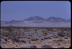
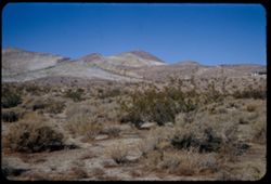
- Description:
- 25 f 11
- Subject:
- Deserts, Mojave Desert (Calif.), Shadows, Mountains, Shrubs, and Clouds
- Series:
- 14-52
- Creator:
- Cushman, Charles W., 1896-1972
- Date Created:
- 1952-04-07
- Genre:
- Landscape photographs
- Frame Number:
- 12
- Street Address:
- United States Highway 6
- County:
- Kern
- Abstract:
- Low dark mtn east of US 6. 10 mi. north of Ricardo.
- Call Number:
- P05996
- City:
- Ricardo
- Country:
- United States
- State/Province:
- California
- Alternate Identifier:
- 1452.12
- Persistent URL:
- http://purl.dlib.indiana.edu/iudl/archives/cushman/P05996
- Holding Location:
- Bloomington - University Archives
Wells Library E460
1320 E 10th St.
Bloomington, IN 47405
Contact at archives@indiana.edu, 812-855-1127
-
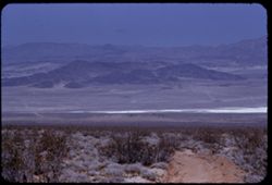
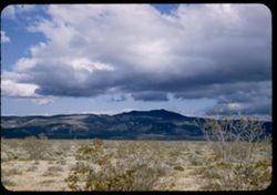
- Description:
- 25 f 8 Pola
- Subject:
- Mountains, Shrubs, Sierra Nevada (Calif. and Nev.), Shadows, and Clouds
- Series:
- 14-52
- Creator:
- Cushman, Charles W., 1896-1972
- Date Created:
- 1952-04-07
- Genre:
- Landscape photographs
- Frame Number:
- 13
- Street Address:
- Ridgecrest-Trona Road
- County:
- Kern and San Bernardino
- Abstract:
- Clouds + mtns in western sky from Ridgecrest-Trona road.
- Call Number:
- P05997
- City:
- Ridgecrest and Trona
- Country:
- United States
- State/Province:
- California
- Alternate Identifier:
- 1452.13
- Persistent URL:
- http://purl.dlib.indiana.edu/iudl/archives/cushman/P05997
- Holding Location:
- Bloomington - University Archives
Wells Library E460
1320 E 10th St.
Bloomington, IN 47405
Contact at archives@indiana.edu, 812-855-1127
-
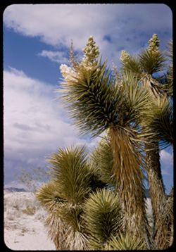
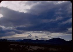
- Description:
- 25 f 11
- Subject:
- Deserts, Mojave Desert (Calif.), Sand, Flowers, Joshua trees, Tree limbs, Shrubs, and Clouds
- Series:
- 14-52
- Creator:
- Cushman, Charles W., 1896-1972
- Date Created:
- 1952-04-07
- Genre:
- Identification photographs
- Frame Number:
- 11
- County:
- Kern
- Abstract:
- Joshua tree near Ricardo.
- Call Number:
- P05995
- City:
- Ricardo
- Country:
- United States
- State/Province:
- California
- Alternate Identifier:
- 1452.11
- Persistent URL:
- http://purl.dlib.indiana.edu/iudl/archives/cushman/P05995
- Holding Location:
- Bloomington - University Archives
Wells Library E460
1320 E 10th St.
Bloomington, IN 47405
Contact at archives@indiana.edu, 812-855-1127
-
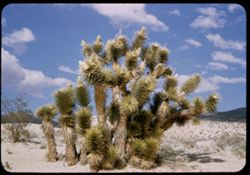
- Description:
- 25 f 11
- Subject:
- Deserts, Mojave Desert (Calif.), Sand, Trees, Joshua trees, Shrubs, Clouds, and Hills
- Series:
- 14-52
- Creator:
- Cushman, Charles W., 1896-1972
- Date Created:
- 1952-04-07
- Genre:
- Identification photographs
- Frame Number:
- 10
- Street Address:
- United States Highway 6
- County:
- Kern
- Abstract:
- Joshua tree near Ricardo.
- Call Number:
- P05994
- City:
- Ricardo
- Country:
- United States
- State/Province:
- California
- Alternate Identifier:
- 1452.10
- Persistent URL:
- http://purl.dlib.indiana.edu/iudl/archives/cushman/P05994
- Holding Location:
- Bloomington - University Archives
Wells Library E460
1320 E 10th St.
Bloomington, IN 47405
Contact at archives@indiana.edu, 812-855-1127
-
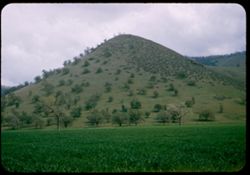
- Description:
- 25 f 9
- Subject:
- Croplands, Meadows, Tehachapi Pass (Calif.), Hills, Shrubs, Trees, Grasses, and Fences
- Series:
- 14-52
- Creator:
- Cushman, Charles W., 1896-1972
- Date Created:
- 1952-04-07
- Genre:
- Landscape photographs
- Frame Number:
- 9
- Street Address:
- United States Highway 466
- County:
- Kern
- Abstract:
- Peaked foothill between Bakersfield and Tehachapi.
- Call Number:
- P05993
- City:
- Tehachapi and Bakersfield
- Country:
- United States
- State/Province:
- California
- Alternate Identifier:
- 1452.9
- Persistent URL:
- http://purl.dlib.indiana.edu/iudl/archives/cushman/P05993
- Holding Location:
- Bloomington - University Archives
Wells Library E460
1320 E 10th St.
Bloomington, IN 47405
Contact at archives@indiana.edu, 812-855-1127