
Search Constraints
You searched for:
Campus
IUB
Remove constraint Campus: IUB
County
Kern
Remove constraint County: Kern
Pages
0-99 pages
Remove constraint Pages: 0-99 pages
Subject
Shrubs
Remove constraint Subject: Shrubs
« Previous |
1 - 20 of 55
|
Next »
Search Results
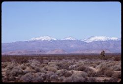
-
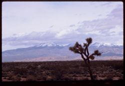
- Description:
- 100 f 9
- Subject:
- Deserts, Mojave Desert (Calif.), Mountains, Shrubs, Cactus, Tehachapi Mountains (Calif.), Clouds, Plains, and Snow
- Series:
- 3-69
- Creator:
- Cushman, Charles W., 1896-1972
- Date Created:
- 1969-03-21
- Genre:
- Landscape photographs
- Frame Number:
- 19
- Street Address:
- California State Highway 58
- County:
- Kern
- Abstract:
- Yellow fields Green hills Hwy 58
- Call Number:
- P15771
- Country:
- United States
- State/Province:
- California
- Alternate Identifier:
- 369.19
- Persistent URL:
- http://purl.dlib.indiana.edu/iudl/archives/cushman/P15771
- Holding Location:
- Bloomington - University Archives
Wells Library E460
1320 E 10th St.
Bloomington, IN 47405
Contact at archives@indiana.edu, 812-855-1127
-
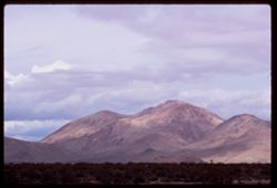
- Description:
- 100 f 9 TL
- Subject:
- Deserts, Mojave Desert (Calif.), Tehachapi Mountains (Calif.), Mountains, Shrubs, and Clouds
- Series:
- 3-69
- Creator:
- Cushman, Charles W., 1896-1972
- Date Created:
- 1969-03-21
- Genre:
- Landscape photographs
- Frame Number:
- 18
- Street Address:
- California State Highway 14
- County:
- Kern
- Abstract:
- Toward Tehachapi Mtns from Hwy 14
- Call Number:
- P15770
- City:
- Mojave
- Country:
- United States
- State/Province:
- California
- Alternate Identifier:
- 369.18
- Persistent URL:
- http://purl.dlib.indiana.edu/iudl/archives/cushman/P15770
- Holding Location:
- Bloomington - University Archives
Wells Library E460
1320 E 10th St.
Bloomington, IN 47405
Contact at archives@indiana.edu, 812-855-1127
-
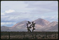
- Description:
- 100 f 9 TL
- Subject:
- Deserts, Mojave Desert (Calif.), Tehachapi Mountains (Calif.), Cactus, Mountains, Fences, Shrubs, and Clouds
- Series:
- 3-69
- Creator:
- Cushman, Charles W., 1896-1972
- Date Created:
- 1969-03-21
- Genre:
- Landscape photographs
- Frame Number:
- 17
- Street Address:
- California State Highway 14
- County:
- Kern
- Abstract:
- Toward Tehachapi Mtns from Hwy 14
- Call Number:
- P15769
- City:
- Mojave
- Country:
- United States
- State/Province:
- California
- Alternate Identifier:
- 369.17
- Persistent URL:
- http://purl.dlib.indiana.edu/iudl/archives/cushman/P15769
- Holding Location:
- Bloomington - University Archives
Wells Library E460
1320 E 10th St.
Bloomington, IN 47405
Contact at archives@indiana.edu, 812-855-1127
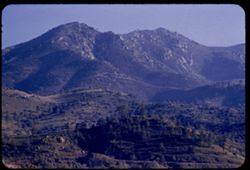
-
- Description:
- 100 f 9 TL
- Subject:
- Trees, Mountains, Shrubs, and Hills
- Series:
- 2-69
- Creator:
- Cushman, Charles W., 1896-1972
- Date Created:
- 1969-03-14
- Genre:
- Landscape photographs
- Frame Number:
- 15
- Street Address:
- California State Highway 14
- County:
- Kern
- Abstract:
- Views NW from Hwy 14 south of Mojave
- Call Number:
- P15732
- City:
- Mojave
- Country:
- United States
- State/Province:
- California
- Alternate Identifier:
- 269.15
- Persistent URL:
- http://purl.dlib.indiana.edu/iudl/archives/cushman/P15732
- Holding Location:
- Bloomington - University Archives
Wells Library E460
1320 E 10th St.
Bloomington, IN 47405
Contact at archives@indiana.edu, 812-855-1127
-
- Description:
- 100 f 9 TL
- Subject:
- Snow, Trees, Plains, Mountains, Shrubs, and Hills
- Series:
- 2-69
- Creator:
- Cushman, Charles W., 1896-1972
- Date Created:
- 1969-03-14
- Genre:
- Landscape photographs
- Frame Number:
- 14
- County:
- Kern
- Abstract:
- Views NW from Hwy 14 south of Mojave
- Call Number:
- P15731
- City:
- Mojave
- Country:
- United States
- State/Province:
- California
- Alternate Identifier:
- 269.14
- Persistent URL:
- http://purl.dlib.indiana.edu/iudl/archives/cushman/P15731
- Holding Location:
- Bloomington - University Archives
Wells Library E460
1320 E 10th St.
Bloomington, IN 47405
Contact at archives@indiana.edu, 812-855-1127
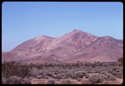
-
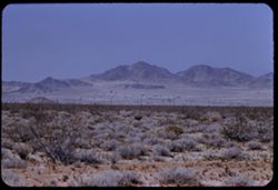
- Description:
- 100 f 8 tl
- Subject:
- Deserts, Mojave Desert (Calif.), Joshua trees, Plains, Mountains, Shrubs, and Clouds
- Series:
- 7-57
- Creator:
- Cushman, Charles W., 1896-1972
- Date Created:
- 1957-05-14
- Genre:
- Landscape photographs
- Frame Number:
- 15
- Street Address:
- United States Highway 6
- County:
- Kern
- Abstract:
- Mountains NW of US 6 north of Rosamond
- Call Number:
- P09294
- City:
- Rosamond
- Country:
- United States
- State/Province:
- California
- Alternate Identifier:
- 757.15
- Persistent URL:
- http://purl.dlib.indiana.edu/iudl/archives/cushman/P09294
- Holding Location:
- Bloomington - University Archives
Wells Library E460
1320 E 10th St.
Bloomington, IN 47405
Contact at archives@indiana.edu, 812-855-1127
-
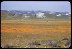
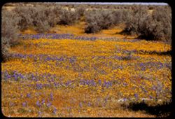
- Description:
- 100 f 5.6 tl
- Subject:
- Wildflowers, Valleys, Poppies, Sand, Temblor Range (Calif.), Mountains, Shrubs, and Hills
- Series:
- 12-55
- Creator:
- Cushman, Charles W., 1896-1972
- Date Created:
- 1955-03-25
- Genre:
- Landscape photographs
- Frame Number:
- 23
- Street Address:
- California State Highway 33 and United States Highway 466
- County:
- Kern
- Abstract:
- Field of poppies & sand hills to west - along US 466 west of Cal 33
- Call Number:
- P07919
- City:
- Blackwells Corner
- Country:
- United States
- State/Province:
- California
- Alternate Identifier:
- 1255.23
- Persistent URL:
- http://purl.dlib.indiana.edu/iudl/archives/cushman/P07919
- Holding Location:
- Bloomington - University Archives
Wells Library E460
1320 E 10th St.
Bloomington, IN 47405
Contact at archives@indiana.edu, 812-855-1127
-
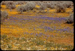
- Description:
- 100 f 5.6 tl 60'
- Subject:
- Wildflowers, Herbs, Shrubs, and Lupines
- Series:
- 12-55
- Creator:
- Cushman, Charles W., 1896-1972
- Date Created:
- 1955-03-25
- Genre:
- Identification photographs
- Frame Number:
- 21
- Street Address:
- United States Highway 466
- County:
- Kern
- Abstract:
- Lupine & yellow
- Call Number:
- P07917
- City:
- Wasco
- Country:
- United States
- State/Province:
- California
- Alternate Identifier:
- 1255.21
- Persistent URL:
- http://purl.dlib.indiana.edu/iudl/archives/cushman/P07917
- Holding Location:
- Bloomington - University Archives
Wells Library E460
1320 E 10th St.
Bloomington, IN 47405
Contact at archives@indiana.edu, 812-855-1127
-
- Description:
- 100 f 5.6 tl 40'
- Subject:
- Shrubs, Herbs, Wildflowers, and Lupines
- Series:
- 12-55
- Creator:
- Cushman, Charles W., 1896-1972
- Date Created:
- 1955-03-25
- Genre:
- Identification photographs
- Frame Number:
- 20
- Street Address:
- United States Highway 466
- County:
- Kern
- Abstract:
- Lupine and yellow flowers
- Call Number:
- P07916
- City:
- Wasco
- Country:
- United States
- State/Province:
- California
- Alternate Identifier:
- 1255.20
- Persistent URL:
- http://purl.dlib.indiana.edu/iudl/archives/cushman/P07916
- Holding Location:
- Bloomington - University Archives
Wells Library E460
1320 E 10th St.
Bloomington, IN 47405
Contact at archives@indiana.edu, 812-855-1127
-
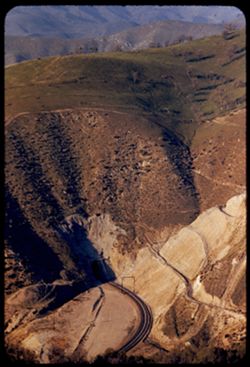
- Description:
- 100 f 4.5 tl
- Subject:
- Tehachapi Mountains (Calif.), Trails & paths, Trees, Mountains, Shrubs, Railroads, Southern Pacific Railroad Company, and Tunnels
- Series:
- 12-55
- Creator:
- Cushman, Charles W., 1896-1972
- Date Created:
- 1955-03-24
- Genre:
- Views
- Frame Number:
- 19
- County:
- Kern
- Abstract:
- So Pac freight, up bound, emerges from tunnel
- Call Number:
- P07915
- City:
- Keene
- Country:
- United States
- State/Province:
- California
- Alternate Identifier:
- 1255.19
- Persistent URL:
- http://purl.dlib.indiana.edu/iudl/archives/cushman/P07915
- Holding Location:
- Bloomington - University Archives
Wells Library E460
1320 E 10th St.
Bloomington, IN 47405
Contact at archives@indiana.edu, 812-855-1127
-
- Description:
- 100 f 4.5 tl
- Subject:
- Rocks, Roads, Tehachapi Mountains (Calif.), Trails & paths, Trees, Mountains, Shrubs, Railroad tracks, Utility poles, and Southern Pacific Railroad Company
- Series:
- 12-55
- Creator:
- Cushman, Charles W., 1896-1972
- Date Created:
- 1955-03-24
- Genre:
- Landscape photographs
- Frame Number:
- 18
- County:
- Kern
- Abstract:
- S P curves, [cut] and tunnel mouth from same vantage point
- Call Number:
- P07914
- City:
- Keene
- Country:
- United States
- State/Province:
- California
- Alternate Identifier:
- 1255.18
- Persistent URL:
- http://purl.dlib.indiana.edu/iudl/archives/cushman/P07914
- Holding Location:
- Bloomington - University Archives
Wells Library E460
1320 E 10th St.
Bloomington, IN 47405
Contact at archives@indiana.edu, 812-855-1127
-
- Description:
- 100 f 4.5 tl
- Subject:
- Roads, Tehachapi Mountains (Calif.), Southern Pacific Tunnel, Trees, Mountains, Tunnels, Railroad tracks, Hills, Utility poles, and Shrubs
- Series:
- 12-55
- Creator:
- Cushman, Charles W., 1896-1972
- Date Created:
- 1955-03-24
- Genre:
- Landscape photographs
- Frame Number:
- 17
- Street Address:
- United States Highway 466
- County:
- Kern
- Abstract:
- S P curves, [cut] and tunnel mouth from same vantage point
- Call Number:
- P07913
- City:
- Keene
- Country:
- United States
- State/Province:
- California
- Alternate Identifier:
- 1255.17
- Persistent URL:
- http://purl.dlib.indiana.edu/iudl/archives/cushman/P07913
- Holding Location:
- Bloomington - University Archives
Wells Library E460
1320 E 10th St.
Bloomington, IN 47405
Contact at archives@indiana.edu, 812-855-1127
-
- Description:
- 100 f 5.6 tl
- Subject:
- Trails & paths, Mountains, Trees, Utility poles, Railroad tracks, Tunnels, Tehachapi Mountains (Calif.), Shrubs, and Southern Pacific Tunnel
- Series:
- 12-55
- Creator:
- Cushman, Charles W., 1896-1972
- Date Created:
- 1955-03-24
- Genre:
- Views
- Frame Number:
- 16
- Street Address:
- United States Highway 466
- County:
- Kern
- Abstract:
- S P below Hwy 466 west of Keene a few miles
- Call Number:
- P07912
- City:
- Keene
- Country:
- United States
- State/Province:
- California
- Alternate Identifier:
- 1255.16
- Persistent URL:
- http://purl.dlib.indiana.edu/iudl/archives/cushman/P07912
- Holding Location:
- Bloomington - University Archives
Wells Library E460
1320 E 10th St.
Bloomington, IN 47405
Contact at archives@indiana.edu, 812-855-1127
-
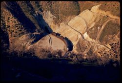
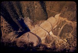
- Description:
- 100 f 5.6 tl
- Subject:
- Rocks, Tehachapi Mountains (Calif.), Trees, Mountains, Shrubs, South Pacific Loop, Utility poles, Railroads, and Southern Pacific Railroad Company
- Series:
- 12-55
- Creator:
- Cushman, Charles W., 1896-1972
- Date Created:
- 1955-03-24
- Genre:
- Landscape photographs
- Frame Number:
- 15
- County:
- Kern
- Persons Pictured:
- Hood, William
- Abstract:
- Mountain above famous Sou. Pac. loop in the Tehachapi built in 1876 by Wm Hood
- Call Number:
- P07911
- Country:
- United States
- State/Province:
- California
- Alternate Identifier:
- 1255.15
- Persistent URL:
- http://purl.dlib.indiana.edu/iudl/archives/cushman/P07911
- Holding Location:
- Bloomington - University Archives
Wells Library E460
1320 E 10th St.
Bloomington, IN 47405
Contact at archives@indiana.edu, 812-855-1127
-
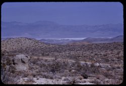
- Description:
- 100 f 8 tl
- Subject:
- Mojave Desert (Calif.), Valleys, Flowers, Mountains, Shrubs, Sierra Nevada (Calif. and Nev.), Hills, Indian Wells Valley (Calif.), and Utility poles
- Series:
- 7-55
- Creator:
- Cushman, Charles W., 1896-1972
- Date Created:
- 1955-03-21
- Genre:
- Landscape photographs
- Frame Number:
- 28
- Street Address:
- Randsburg Road and Trona Road
- County:
- Kern
- Abstract:
- West from just above junction - view across Indiana Wells Valley toward Inyokern and Sierra beyond
- Call Number:
- P07752
- City:
- Inyokern
- Country:
- United States
- State/Province:
- California
- Alternate Identifier:
- 755.28
- Persistent URL:
- http://purl.dlib.indiana.edu/iudl/archives/cushman/P07752
- Holding Location:
- Bloomington - University Archives
Wells Library E460
1320 E 10th St.
Bloomington, IN 47405
Contact at archives@indiana.edu, 812-855-1127
-
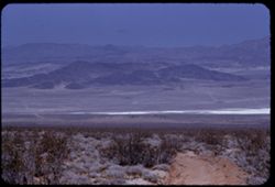
- Description:
- 100 f 8 tl
- Subject:
- Mojave Desert (Calif.), Valleys, Trails & paths, Argus Range (Calif.), Mountains, Shrubs, Lakes & ponds, Hills, and Fog
- Series:
- 7-55
- Creator:
- Cushman, Charles W., 1896-1972
- Date Created:
- 1955-03-21
- Genre:
- Landscape photographs
- Frame Number:
- 27
- Street Address:
- Inyokern Road and Trona Road
- County:
- Kern and San Bernardino
- Abstract:
- View north across valley from 3 miles south of junction with Inyokern - Trona rd.
- Call Number:
- P07751
- City:
- China Lake
- Country:
- United States
- State/Province:
- California
- Alternate Identifier:
- 755.27
- Persistent URL:
- http://purl.dlib.indiana.edu/iudl/archives/cushman/P07751
- Holding Location:
- Bloomington - University Archives
Wells Library E460
1320 E 10th St.
Bloomington, IN 47405
Contact at archives@indiana.edu, 812-855-1127
-
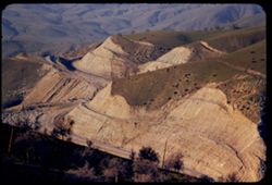
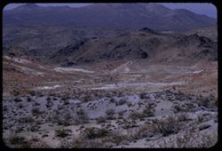
- Description:
- 100 f 8 tl
- Subject:
- Rocks, Valleys, Dirt roads, Argus Range (Calif.), Mountains, Shrubs, and Hills
- Series:
- 7-55
- Creator:
- Cushman, Charles W., 1896-1972
- Date Created:
- 1955-03-21
- Genre:
- Landscape photographs
- Frame Number:
- 23
- Street Address:
- Johannesburg Road and Trona Road
- County:
- Kern and San Bernardino
- Abstract:
- NNE toward China Lake and Argus Mtns from top of Johannesburg - Trona road about midway
- Call Number:
- P07747
- City:
- China Lake
- Country:
- United States
- State/Province:
- California
- Alternate Identifier:
- 755.23
- Persistent URL:
- http://purl.dlib.indiana.edu/iudl/archives/cushman/P07747
- Holding Location:
- Bloomington - University Archives
Wells Library E460
1320 E 10th St.
Bloomington, IN 47405
Contact at archives@indiana.edu, 812-855-1127
-
- Description:
- 100 f 8 tl
- Subject:
- Valleys, Roads, Mountains, Shrubs, and Hills
- Series:
- 7-55
- Creator:
- Cushman, Charles W., 1896-1972
- Date Created:
- 1955-03-21
- Genre:
- Landscape photographs
- Frame Number:
- 22
- Street Address:
- Johannesburg Road and Trona Road
- County:
- Kern and San Bernardino
- Abstract:
- Bad Lands west of J - T road
- Call Number:
- P07746
- City:
- Randsburg
- Country:
- United States
- State/Province:
- California
- Alternate Identifier:
- 755.22
- Persistent URL:
- http://purl.dlib.indiana.edu/iudl/archives/cushman/P07746
- Holding Location:
- Bloomington - University Archives
Wells Library E460
1320 E 10th St.
Bloomington, IN 47405
Contact at archives@indiana.edu, 812-855-1127
-
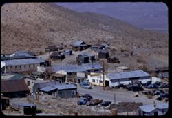
- Description:
- 100 f 6.3 tl
- Subject:
- Valleys, Hills, Roads, Utility poles, Electric lines, Stores & shops, Buildings, Vehicles, Signs (Notices), Automobile service stations, and Shrubs
- Series:
- 7-55
- Creator:
- Cushman, Charles W., 1896-1972
- Date Created:
- 1955-03-21
- Genre:
- Cityscape photographs
- Frame Number:
- 19
- County:
- Kern
- Abstract:
- East part of Randsburg from near bus section
- Call Number:
- P07743
- City:
- Randsburg
- Country:
- United States
- State/Province:
- California
- Alternate Identifier:
- 755.19
- Persistent URL:
- http://purl.dlib.indiana.edu/iudl/archives/cushman/P07743
- Holding Location:
- Bloomington - University Archives
Wells Library E460
1320 E 10th St.
Bloomington, IN 47405
Contact at archives@indiana.edu, 812-855-1127
-
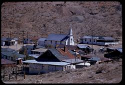
- Description:
- 100 f 5.6 tl
- Subject:
- Crosses, Electric lines, Dirt roads, Buildings, Clotheslines, Dwellings, Hills, Utility poles, Churches, and Shrubs
- Series:
- 7-55
- Creator:
- Cushman, Charles W., 1896-1972
- Date Created:
- 1955-03-21
- Genre:
- Cityscape photographs
- Frame Number:
- 18
- Street Address:
- School Heights
- County:
- Kern
- Abstract:
- East part of Randsburg from School Heights
- Call Number:
- P07742
- City:
- Randsburg
- Country:
- United States
- State/Province:
- California
- Alternate Identifier:
- 755.18
- Persistent URL:
- http://purl.dlib.indiana.edu/iudl/archives/cushman/P07742
- Holding Location:
- Bloomington - University Archives
Wells Library E460
1320 E 10th St.
Bloomington, IN 47405
Contact at archives@indiana.edu, 812-855-1127
- « Previous
- Next »
- 1
- 2
- 3