
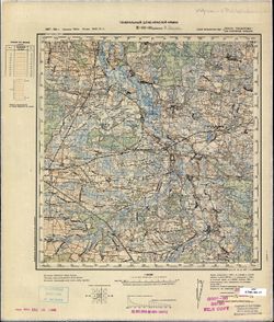
Search Constraints
You searched for:
Campus
IUB
Remove constraint Campus: IUB
Date Created
1940
Remove constraint Date Created: 1940
Type
Image
Remove constraint Type: Image
Pages
0-99 pages
Remove constraint Pages: 0-99 pages
Search Results
-
- Description:
- 1893
- Subject:
- Topical Subject: Soviet Union, Geographic Subject: Chmielnik, and Topical Subject: Maps
- Publisher:
- Генеральный штаб Красной Армии
- Language:
- Russian
- Date Created:
- 1940
- Identifier:
- VAC9619-002855
- Genre:
- Topographic Maps and Military Maps
- Geographic Location:
- Coordinates: 50.333, 20.5, 50.667, 21
- Related URL:
- Download GeoTIFF: https://drive.google.com/file/d/1m0vD5fHdYbL1cVLjgWcbbJuNqVlzbaYs/view?usp=sharing and Catalog URL: https://iucat.iu.edu/catalog/5020129
- Abstract:
- Modern area represented: Chmielnik, Świętokrzyskie province, Poland
- Call Number:
- G7000 s100 .S7 sheet M-34-54
- City:
- Хмельник (Chmielnik)
- Copyright Holder:
- No Copyright - United States
- State/Province:
- Область государственных интересов Германии (Region of German state interests)
- Physical Description:
- Scale: 1:100,000
- Persistent URL:
- http://purl.dlib.indiana.edu/iudl/images/VAC9619/VAC9619-002855
- Provenance:
- DMA Topographic Center, Army Map Service Library, Library of Congress Geography & Map Division, Geographic Names Branch
-
- Description:
- 1895
- Subject:
- Topical Subject: Soviet Union, Topical Subject: Maps, and Geographic Subject: Jędrzejów
- Publisher:
- Генеральный штаб Красной Армии
- Language:
- Russian
- Date Created:
- 1940
- Identifier:
- VAC9619-002854
- Genre:
- Military Maps and Topographic Maps
- Geographic Location:
- Coordinates: 50.333, 20, 50.667, 20.5
- Related URL:
- Catalog URL: https://iucat.iu.edu/catalog/5020129 and Download GeoTIFF: https://drive.google.com/file/d/1a3ZFZV7QLg3yM0GPS100bYjRs810vrlM/view?usp=sharing
- Abstract:
- Modern area represented: Jędrzejów, Świętokrzyskie province, Poland
- Call Number:
- G7000 s100 .S7 sheet M-34-53
- City:
- Енджеюв (Jędrzejów)
- Copyright Holder:
- No Copyright - United States
- State/Province:
- Область государственных интересов Германии (Region of German state interests)
- Physical Description:
- Scale: 1:100,000
- Persistent URL:
- http://purl.dlib.indiana.edu/iudl/images/VAC9619/VAC9619-002854
- Provenance:
- DMA Topographic Center, Army Map Service Library, Library of Congress Geography & Map Division
-
- Description:
- 1895
- Subject:
- Geographic Subject: Wolbrom, Topical Subject: Soviet Union, and Topical Subject: Maps
- Publisher:
- Генеральный штаб Красной Армии
- Language:
- Russian
- Date Created:
- 1940
- Identifier:
- VAC9619-002853
- Genre:
- Topographic Maps and Military Maps
- Geographic Location:
- Coordinates: 50.333, 19.5, 50.667, 20
- Related URL:
- Download GeoTIFF: https://drive.google.com/file/d/1iHIjYjAaY6TM6L5HiCmvn7MvbWxNxz7P/view?usp=sharing and Catalog URL: https://iucat.iu.edu/catalog/5020129
- Abstract:
- Modern area represented: Wolbrom, Lesser Poland province, Poland
- Call Number:
- G7000 s100 .S7 sheet M-34-52
- City:
- Вольбром (Wolbrom)
- Copyright Holder:
- No Copyright - United States
- State/Province:
- Область государственных интересов Германии (Region of German state interests)
- Physical Description:
- Scale: 1:100,000
- Persistent URL:
- http://purl.dlib.indiana.edu/iudl/images/VAC9619/VAC9619-002853
- Provenance:
- DMA Topographic Center, Army Map Service Library, OMAHA
-
- Description:
- 1881
- Subject:
- Topical Subject: Soviet Union, Topical Subject: Maps, and Geographic Subject: Zawiercie
- Publisher:
- Генеральный штаб Красной Армии
- Language:
- Russian
- Date Created:
- 1940
- Identifier:
- VAC9619-002831
- Genre:
- Topographic Maps and Military Maps
- Geographic Location:
- Coordinates: 50.333, 19, 50.666, 19.5
- Related URL:
- Catalog URL: https://iucat.iu.edu/catalog/5020129 and Download GeoTIFF: https://drive.google.com/file/d/1I6FP3jxW2IQKJN78MHQOxsR66qID6VfU/view?usp=sharing
- Abstract:
- Modern area represented: Zawiercie, Silesia province, Poland
- Call Number:
- G7000 s100 .S7 sheet M-34-51
- City:
- Заверце (Zawiercie)
- Copyright Holder:
- No Copyright - United States
- Country:
- Германия (Germany)
- State/Province:
- Область государственных интересов Германии (Region of German state interests)
- Physical Description:
- Scale: 1:100,000
- Persistent URL:
- http://purl.dlib.indiana.edu/iudl/images/VAC9619/VAC9619-002831
- Provenance:
- DMA Topographic Center, Army Map Service Library, OMAHA
-
- Description:
- 1881
- Subject:
- Topical Subject: Maps, Topical Subject: Soviet Union, and Geographic Subject: Bytom
- Publisher:
- Генеральный штаб Красной Армии
- Language:
- Russian
- Date Created:
- 1940
- Identifier:
- VAC9619-002830
- Genre:
- Topographic Maps and Military Maps
- Geographic Location:
- Coordinates: 50.333, 18.5, 50.667, 19
- Related URL:
- Download GeoTIFF: https://drive.google.com/file/d/1F1kYHexEwvuxUTVXMVQlMoytxx2mAwha/view?usp=sharing and Catalog URL: https://iucat.iu.edu/catalog/5020129
- Abstract:
- Modern area represented: Bytom, Silesia province, Poland
- Call Number:
- G7000 s100 .S7 sheet M-34-50
- City:
- Беутен (Beuthen)
- Copyright Holder:
- No Copyright - United States
- Country:
- Германия (Germany)
- State/Province:
- Область государственных интересов Германии (Region of German state interests)
- Physical Description:
- Scale: 1:100,000
- Persistent URL:
- http://purl.dlib.indiana.edu/iudl/images/VAC9619/VAC9619-002830
- Provenance:
- DMA Topographic Center, OMAHA
-
- Description:
- 1881
- Subject:
- Topical Subject: Maps, Topical Subject: Soviet Union, and Geographic Subject: Strzelce Opolskie
- Publisher:
- Генеральный штаб Красной Армии
- Language:
- Russian
- Date Created:
- 1940
- Identifier:
- VAC9619-002829
- Genre:
- Topographic Maps and Military Maps
- Geographic Location:
- Coordinates: 50.333, 18, 50.667, 18.5
- Related URL:
- Download GeoTIFF: https://drive.google.com/file/d/1-gmESuCfsrBOp7j-ohnildukr_nGIopT/view?usp=sharing and Catalog URL: https://iucat.iu.edu/catalog/5020129
- Abstract:
- Modern area represented: Strzelce Opolskie, Opole province, Poland
- Call Number:
- G7000 s100 .S7 sheet M-34-49
- City:
- Гросс Стрелитц (Groß Strehlitz)
- Copyright Holder:
- No Copyright - United States
- Country:
- Германия (Germany)
- Physical Description:
- Scale: 1:100,000
- Persistent URL:
- http://purl.dlib.indiana.edu/iudl/images/VAC9619/VAC9619-002829
- Provenance:
- DMA Topographic Center, Army Map Service Library, OMAHA
-
- Description:
- 1888
- Subject:
- Topical Subject: Soviet Union, Topical Subject: Maps, and Geographic Subject: Hrubieszów
- Publisher:
- Генеральный штаб Красной Армии
- Language:
- Russian
- Date Created:
- 1940
- Identifier:
- VAC9619-002828
- Genre:
- Topographic Maps and Military Maps
- Geographic Location:
- Coordinates: 50.667, 23.5, 51, 24
- Related URL:
- Catalog URL: https://iucat.iu.edu/catalog/5020129 and Download GeoTIFF: https://drive.google.com/file/d/1MtYYusftksd1g2h3UGfdgt847CDumZ60/view?usp=sharing
- Abstract:
- Modern area represented: Hrubieszów, Lublin province, Poland
- Call Number:
- G7000 s100 .S7 sheet M-34-48
- City:
- Грубешув (Hrubieszów)
- Copyright Holder:
- No Copyright - United States
- State/Province:
- Область государственных интересов Германии (Region of German state interests), Волынская область (Volyn oblast), and Украинская ССР (Ukrainian Soviet Sociali...
- Physical Description:
- Scale: 1:100,000
- Persistent URL:
- http://purl.dlib.indiana.edu/iudl/images/VAC9619/VAC9619-002828
- Provenance:
- DMA Topographic Center, Army Map Service Library, OMAHA
-
- Description:
- 1892
- Subject:
- Topical Subject: Soviet Union, Topical Subject: Maps, and Geographic Subject: Szczebrzeszyn
- Publisher:
- Генеральный штаб Красной Армии
- Language:
- Russian
- Date Created:
- 1940
- Identifier:
- VAC9619-002827
- Genre:
- Military Maps and Topographic Maps
- Geographic Location:
- Coordinates: 50.667, 22.5, 51, 23
- Related URL:
- Catalog URL: https://iucat.iu.edu/catalog/5020129 and Download GeoTIFF: https://drive.google.com/file/d/179Vk3pcwTFYow2S1dTo09WD46KNSBynM/view?usp=sharing
- Abstract:
- Modern area represented: Szczebrzeszyn, Lublin province, Poland
- Call Number:
- G7000 s100 .S7 sheet M-34-46
- City:
- Щебжешин (Szczebrzeszyn)
- Copyright Holder:
- No Copyright - United States
- State/Province:
- Область государственных интересов Германии (Region of German state interests)
- Physical Description:
- Scale: 1:100,000
- Persistent URL:
- http://purl.dlib.indiana.edu/iudl/images/VAC9619/VAC9619-002827
- Provenance:
- DMA Topographic Center, Army Map Service Library, OMAHA
-
- Description:
- 1892
- Subject:
- Topical Subject: Soviet Union, Geographic Subject: Janów Lubelski, and Topical Subject: Maps
- Publisher:
- Генеральный штаб Красной Армии
- Language:
- Russian
- Date Created:
- 1940
- Identifier:
- VAC9619-002826
- Genre:
- Topographic Maps and Military Maps
- Geographic Location:
- Coordinates: 50.667, 22, 51, 22.5
- Related URL:
- Catalog URL: https://iucat.iu.edu/catalog/5020129 and Download GeoTIFF: https://drive.google.com/file/d/1AY-JA0ncQsjHvr0Mx5FpJCbhvnLKHBM0/view?usp=sharing
- Abstract:
- Modern area represented: Janów Lubelski, Lublin province, Poland
- Call Number:
- G7000 s100 .S7 sheet M-34-45
- City:
- Янув (Janów)
- Copyright Holder:
- No Copyright - United States
- State/Province:
- Область государственных интересов Германии (Region of German state interests)
- Physical Description:
- Scale: 1:100,000
- Persistent URL:
- http://purl.dlib.indiana.edu/iudl/images/VAC9619/VAC9619-002826
- Provenance:
- DMA Topographic Center, Army Map Service Library, OMAHA
-
- Description:
- 1875
- Subject:
- Topical Subject: Maps, Topical Subject: Soviet Union, and Geographic Subject: Sandomierz
- Publisher:
- Генеральный штаб Красной Армии
- Language:
- Russian
- Date Created:
- 1940
- Identifier:
- VAC9619-002825
- Genre:
- Topographic Maps and Military Maps
- Geographic Location:
- Coordinates: 50.667, 21.5, 51, 22
- Related URL:
- Catalog URL: https://iucat.iu.edu/catalog/5020129 and Download GeoTIFF: https://drive.google.com/file/d/1KiA7_ShZQB-otKNYycRHoq8BcwFgP9Lg/view?usp=sharing
- Abstract:
- Modern area represented: Sandomierz, Świętokrzyskie province, Poland
- Call Number:
- G7000 s100 .S7 sheet M-34-44
- City:
- Сандомир (Sandomierz)
- Copyright Holder:
- No Copyright - United States
- State/Province:
- Область государственных интересов Германии (Region of German state interests)
- Physical Description:
- Scale: 1:100,000
- Persistent URL:
- http://purl.dlib.indiana.edu/iudl/images/VAC9619/VAC9619-002825
- Provenance:
- DMA Topographic Center, Army Map Service Library, OMAHA
-
- Description:
- 1893
- Subject:
- Geographic Subject: Ostrowiec Świętokrzyski, Topical Subject: Soviet Union, and Topical Subject: Maps
- Publisher:
- Генеральный штаб Красной Армии
- Language:
- Russian
- Date Created:
- 1940
- Identifier:
- VAC9619-002824
- Genre:
- Topographic Maps and Military Maps
- Geographic Location:
- Coordinates: 50.667, 21, 51, 21.5
- Related URL:
- Download GeoTIFF: https://drive.google.com/file/d/1dCs56aJfHbIoqFvjV3G6y_azZfMDjo25/view?usp=sharing and Catalog URL: https://iucat.iu.edu/catalog/5020129
- Abstract:
- Modern area represented: Ostrowiec Świętokrzyski, Świętokrzyskie province, Poland
- Call Number:
- G7000 s100 .S7 sheet M-34-43
- City:
- Островец (Ostrowiec)
- Copyright Holder:
- No Copyright - United States
- State/Province:
- Область государственных интересов Германии (Region of German state interests)
- Physical Description:
- Scale: 1:100,000
- Persistent URL:
- http://purl.dlib.indiana.edu/iudl/images/VAC9619/VAC9619-002824
- Provenance:
- DMA Topographic Center, OMAHA
-
- Description:
- 1882
- Subject:
- Topical Subject: Maps, Geographic Subject: Krnov, and Topical Subject: Soviet Union
- Publisher:
- Генеральный штаб Красной Армии
- Language:
- Russian
- Date Created:
- 1940
- Identifier:
- VAC9619-002680
- Genre:
- Military Maps and Topographic Maps
- Geographic Location:
- Coordinates: 50.0, 17.5, 50.3333, 18.0
- Related URL:
- Download GeoTIFF: https://drive.google.com/file/d/1OsA4NUrYek1eUbOu3RQ7WCt-bX_ATsS8/view?usp=sharing and Catalog URL: https://iucat.iu.edu/catalog/5020129
- Abstract:
- Modern area represented: Krnov, Moravian-Silesian region, Czech Republic
- Call Number:
- G7000 s100 .S7 sheet M-33-72
- City:
- Егерндорф (Jägerndorf)
- Copyright Holder:
- No Copyright - United States
- Country:
- Германия (Germany)
- Physical Description:
- Scale: 1:100,000
- Persistent URL:
- http://purl.dlib.indiana.edu/iudl/images/VAC9619/VAC9619-002680
- Provenance:
- DMA Topographic Center, Army Map Service Library, Auswärtiges Amt. Geographischer Dienst
-
- Description:
- 1881
- Subject:
- Geographic Subject: Głuchołazy, Topical Subject: Maps, and Topical Subject: Soviet Union
- Publisher:
- Генеральный штаб Красной Армии
- Language:
- Russian
- Date Created:
- 1940
- Identifier:
- VAC9619-002679
- Genre:
- Topographic Maps and Military Maps
- Geographic Location:
- Coordinates: 50.0, 17.0, 50.3333, 17.5
- Related URL:
- Download GeoTIFF: https://drive.google.com/file/d/1eko3WswhFBLCUjkvMJYg1RtqlgNPdXg4/view?usp=sharing and Catalog URL: https://iucat.iu.edu/catalog/5020129
- Abstract:
- Modern area represented: Głuchołazy, Opole province, Poland
- Call Number:
- G7000 s100 .S7 sheet M-33-71
- City:
- Цигенхальс (Ziegenhals)
- Copyright Holder:
- No Copyright - United States
- Country:
- Германия (Germany)
- Physical Description:
- Scale: 1:100,000
- Persistent URL:
- http://purl.dlib.indiana.edu/iudl/images/VAC9619/VAC9619-002679
- Provenance:
- DMA Topographic Center, Library of Congress Geography & Map Division, Army Map Service Library, OMAHA
-
- Description:
- 1881
- Subject:
- Geographic Subject: Bystrzyca Kłodzka, Topical Subject: Soviet Union, and Topical Subject: Maps
- Publisher:
- Генеральный штаб Красной Армии
- Language:
- Russian
- Date Created:
- 1940
- Identifier:
- VAC9619-002678
- Genre:
- Military Maps and Topographic Maps
- Geographic Location:
- Coordinates: 50.0, 16.5, 50.3333, 17.0
- Related URL:
- Catalog URL: https://iucat.iu.edu/catalog/5020129 and Download GeoTIFF: https://drive.google.com/file/d/1-KppvaFgw7CxdcIFF1CmM1ATyLDv3uit/view?usp=sharing
- Abstract:
- Modern area represented: Bystrzyca Kłodzka, Lower Silesian province, Poland
- Call Number:
- G7000 s100 .S7 sheet M-33-70
- City:
- Габельшвердт (Habelschwerdt)
- Copyright Holder:
- No Copyright - United States
- Country:
- Германия (Germany)
- State/Province:
- Протекторат Богемии и Моравии (Protectorate of Bohemia and Moravia)
- Physical Description:
- Scale: 1:100,000
- Persistent URL:
- http://purl.dlib.indiana.edu/iudl/images/VAC9619/VAC9619-002678
- Provenance:
- DMA Topographic Center, Library of Congress Geography & Map Division, Army Map Service Library, Geographic Names Branch, OMAHA, Reichsamt für Landesaufna...
-
- Description:
- 1883
- Subject:
- Topical Subject: Maps, Topical Subject: Soviet Union, and Geographic Subject: Opole
- Publisher:
- Генеральный штаб Красной Армии
- Language:
- Russian
- Date Created:
- 1940
- Identifier:
- VAC9619-002676
- Genre:
- Topographic Maps and Military Maps
- Geographic Location:
- Coordinates: 50.3333, 17.5, 50.6667, 18.0
- Related URL:
- Download GeoTIFF: https://drive.google.com/file/d/1zZ7IVy_B0EcLhdD-Q1sxl0__k-upeH_v/view?usp=sharing and Catalog URL: https://iucat.iu.edu/catalog/5020129
- Abstract:
- Modern area represented: Opole, Opole province, Poland
- Call Number:
- G7000 s100 .S7 sheet M-33-60
- City:
- Оппельн (Oppeln)
- Copyright Holder:
- No Copyright - United States
- Country:
- Германия (Germany)
- Physical Description:
- Scale: 1:100,000
- Persistent URL:
- http://purl.dlib.indiana.edu/iudl/images/VAC9619/VAC9619-002676
- Provenance:
- DMA Topographic Center, Library of Congress Geography & Map Division, Army Map Service Library, Geographic Names Branch, OMAHA
-
- Description:
- 1881
- Subject:
- Topical Subject: Maps, Geographic Subject: Nysa, and Topical Subject: Soviet Union
- Publisher:
- Генеральный штаб Красной Армии
- Language:
- Russian
- Date Created:
- 1940
- Identifier:
- VAC9619-002675
- Genre:
- Military Maps and Topographic Maps
- Geographic Location:
- Coordinates: 50.3333, 17.0, 50.6667, 17.5
- Related URL:
- Download GeoTIFF: https://drive.google.com/file/d/1pIH_KuPyBng-yoZCWbb9826cQnGspSKE/view?usp=sharing and Catalog URL: https://iucat.iu.edu/catalog/5020129
- Abstract:
- Modern area represented: Nysa, Opole Province, Poland
- Call Number:
- G7000 s100 .S7 sheet M-33-59
- City:
- Нейссе (Neisse)
- Copyright Holder:
- No Copyright - United States
- Country:
- Германия (Germany)
- Physical Description:
- Scale: 1:100,000
- Persistent URL:
- http://purl.dlib.indiana.edu/iudl/images/VAC9619/VAC9619-002675
- Provenance:
- DMA Topographic Center, Army Map Service Library
-
- Description:
- 1881
- Subject:
- Topical Subject: Maps, Topical Subject: Soviet Union, and Geographic Subject: Kłodzko
- Publisher:
- Генеральный штаб Красной Армии
- Language:
- Russian
- Date Created:
- 1940
- Identifier:
- VAC9619-002674
- Genre:
- Military Maps and Topographic Maps
- Geographic Location:
- Coordinates: 50.3333, 16.5, 50.6667, 17.0
- Related URL:
- Download GeoTIFF: https://drive.google.com/file/d/1O5qHBrm7cBmiCJ45DWbhDWidRAMOieHm/view?usp=sharing and Catalog URL: https://iucat.iu.edu/catalog/5020129
- Abstract:
- Modern area represented: Kłodzko, Lower Silesia province, Poland
- Call Number:
- G7000 s100 .S7 sheet M-33-58
- City:
- Глатц (Glatz)
- Copyright Holder:
- No Copyright - United States
- Country:
- Германия (Germany)
- Physical Description:
- Scale: 1:100,000
- Persistent URL:
- http://purl.dlib.indiana.edu/iudl/images/VAC9619/VAC9619-002674
- Provenance:
- DMA Topographic Center, Army Map Service Library, Library of Congress Geography & Map Division, Geographic Names Branch, OMAHA, Reichsamt für Landesaufna...
-
- Description:
- 1883
- Subject:
- Geographic Subject: Lewin Brzeski, Topical Subject: Maps, and Topical Subject: Soviet Union
- Publisher:
- Генеральный штаб Красной Армии
- Language:
- Russian
- Date Created:
- 1940
- Identifier:
- VAC9619-002672
- Genre:
- Military Maps and Topographic Maps
- Geographic Location:
- Coordinates: 50.66667, 17.5, 51.0, 18.0
- Related URL:
- Download GeoTIFF: https://drive.google.com/file/d/1efqECY_1fb-X-YuBKxwOnxrtOYrrelJs/view?usp=sharing and Catalog URL: https://iucat.iu.edu/catalog/5020129
- Abstract:
- Modern area represented: Lewin Brzeski, Opole province, Poland
- Call Number:
- G7000 s100 .S7 sheet M-33-48
- City:
- Левен (Lewin)
- Copyright Holder:
- No Copyright - United States
- Country:
- Германия (Germany)
- Physical Description:
- Scale: 1:100,000
- Persistent URL:
- http://purl.dlib.indiana.edu/iudl/images/VAC9619/VAC9619-002672
- Provenance:
- DMA Topographic Center, Army Map Service Library, Library of Congress Geography & Map Division, Geographic Names Branch
-
- Description:
- 1883
- Subject:
- Geographic Subject: Oława, Topical Subject: Maps, and Topical Subject: Soviet Union
- Publisher:
- Генеральный штаб Красной Армии
- Language:
- Russian
- Date Created:
- 1940
- Identifier:
- VAC9619-002671
- Genre:
- Topographic Maps and Military Maps
- Geographic Location:
- Coordinates: 50.66667, 17.0, 51.0, 17.5
- Related URL:
- Download GeoTIFF: https://drive.google.com/file/d/1Qg4kTVxI2fTFtLyW8ACRRXTAs72cReNX/view?usp=sharing and Catalog URL: https://iucat.iu.edu/catalog/5020129
- Abstract:
- Modern area represented: Oława, Lower Silesia, Poland
- Call Number:
- G7000 s100 .S7 sheet M-33-47
- City:
- Олау (Ohlau)
- Copyright Holder:
- No Copyright - United States
- Country:
- Германия (Germany)
- Physical Description:
- Scale: 1:100,000
- Persistent URL:
- http://purl.dlib.indiana.edu/iudl/images/VAC9619/VAC9619-002671
- Provenance:
- DMA Topographic Center, Library of Congress Geography & Map Division, Army Map Service Library, Geographic Names Branch, OMAHA
-
- Description:
- 1881
- Subject:
- Topical Subject: Soviet Union, Topical Subject: Maps, and Geographic Subject: Dzierżoniów
- Publisher:
- Генеральный штаб Красной Армии
- Language:
- Russian
- Date Created:
- 1940
- Identifier:
- VAC9619-002670
- Genre:
- Military Maps and Topographic Maps
- Geographic Location:
- Coordinates: 50.667, 16.5, 51, 17
- Related URL:
- Download GeoTIFF: https://drive.google.com/file/d/1rqQN58cHNXRGgmzg-fcO04CM6yviyFlr/view?usp=sharing and Catalog URL: https://iucat.iu.edu/catalog/5020129
- Abstract:
- Modern area represented: Dzierżoniów, Lower Silesian province, Poland
- Call Number:
- G7000 s100 .S7 sheet M-33-46
- City:
- Рейхенбах (Reichenbach)
- Copyright Holder:
- No Copyright - United States
- Country:
- Германия (Germany)
- Physical Description:
- Scale: 1:100,000
- Persistent URL:
- http://purl.dlib.indiana.edu/iudl/images/VAC9619/VAC9619-002670
- Provenance:
- DMA Topographic Center, Auswärtiges Amt. Geographischer Dienst
-
- Description:
- 1884
- Subject:
- Geographic Subject: Namysłów, Topical Subject: Maps, and Topical Subject: Soviet Union
- Publisher:
- Генеральный штаб Красной Армии
- Language:
- Russian
- Date Created:
- 1940
- Identifier:
- VAC9619-002610
- Genre:
- Military Maps and Topographic Maps
- Geographic Location:
- Coordinates: 51, 17.5, 51.333, 18
- Related URL:
- Download GeoTIFF: https://drive.google.com/file/d/1kh7SD0fdDpNwq7RJtiSbuc_6xG5igIfc/view?usp=sharing and Catalog URL: https://iucat.iu.edu/catalog/5020129
- Abstract:
- Modern area represented: Namysłów, Opole province, Poland
- Call Number:
- G7000 s100 .S7 sheet M-33-36
- City:
- Намслау (Namysłów)
- Copyright Holder:
- No Copyright - United States
- Country:
- Германия (Germany)
- Physical Description:
- Scale: 1:100,000
- Persistent URL:
- http://purl.dlib.indiana.edu/iudl/images/VAC9619/VAC9619-002610
- Provenance:
- DMA Topographic Center, Library of Congress G & M Division, Army Map Service Library, Geographic Names Branch, OMAHA
-
- Description:
- 1885
- Subject:
- Topical Subject: Maps, Geographic Subject: Wrocław, and Topical Subject: Soviet Union
- Publisher:
- Генеральный штаб Красной Армии
- Language:
- Russian
- Date Created:
- 1940
- Identifier:
- VAC9619-002609
- Genre:
- Military Maps and Topographic Maps
- Geographic Location:
- Coordinates: 51, 17, 51.333, 17.5
- Related URL:
- Download GeoTIFF: https://drive.google.com/file/d/1uFzjhoF6Wx5vOPw0Sp0CN4JZTK3BNnQ6/view?usp=sharing and Catalog URL: https://iucat.iu.edu/catalog/5020129
- Abstract:
- Modern area represented: Wrocław, Lower Silesia province, Poland
- Call Number:
- G7000 s100 .S7 sheet M-33-35
- City:
- Бреслау (Wrocław)
- Copyright Holder:
- No Copyright - United States
- Country:
- Германия (Germany)
- Physical Description:
- Scale: 1:100,000
- Persistent URL:
- http://purl.dlib.indiana.edu/iudl/images/VAC9619/VAC9619-002609
- Provenance:
- DMA Topographic Center, Library of Congress G & M Division, Army Map Service Library, Auswärtiges Amt. Geographischer Dienst, OMAHA
-
- Description:
- 1886
- Subject:
- Topical Subject: Maps, Geographic Subject: Środa Śląska, and Topical Subject: Soviet Union
- Publisher:
- Генеральный штаб Красной Армии
- Language:
- Russian
- Date Created:
- 1940
- Identifier:
- VAC9619-002608
- Genre:
- Military Maps and Topographic Maps
- Geographic Location:
- Coordinates: 51, 16.5, 51.333, 17
- Related URL:
- Download GeoTIFF: https://drive.google.com/file/d/1SrSMPElmJIrozUCQVb61cLpQRrS4bJkm/view?usp=sharing and Catalog URL: https://iucat.iu.edu/catalog/5020129
- Abstract:
- Modern area represented: Środa Śląska, Lower Silesian province, Poland
- Call Number:
- G7000 s100 .S7 sheet M-33-34
- City:
- Ноймаркт (Neumarkt)
- Copyright Holder:
- No Copyright - United States
- Country:
- Германия (Germany)
- Physical Description:
- Scale: 1:100,000
- Persistent URL:
- http://purl.dlib.indiana.edu/iudl/images/VAC9619/VAC9619-002608
- Provenance:
- DMA Topographic Center, Library of Congress G & M Division, Army Map Service Library, Auswärtiges Amt. Geographischer Dienst, OMAHA
-
- Description:
- 1885
- Subject:
- Geographic Subject: Milicz, Topical Subject: Soviet Union, and Topical Subject: Maps
- Publisher:
- Генеральный штаб Красной Армии
- Language:
- Russian
- Date Created:
- 1940
- Identifier:
- VAC9619-002606
- Genre:
- Topographic Maps and Military Maps
- Geographic Location:
- Coordinates: 51.333, 17, 51.667, 17.5
- Related URL:
- Download GeoTIFF: https://drive.google.com/file/d/11cAPL6zvsZLMCrE0g3mRTOEqO4lK5fuh/view?usp=sharing and Catalog URL: https://iucat.iu.edu/catalog/5020129
- Abstract:
- Modern area represented: Milicz, Lower Silesian province, Poland
- Call Number:
- G7000 s100 .S7 sheet M-33-23
- City:
- Милич (Milicz)
- Copyright Holder:
- No Copyright - United States
- Country:
- Германия (Germany)
- Physical Description:
- Scale: 1:100,000
- Persistent URL:
- http://purl.dlib.indiana.edu/iudl/images/VAC9619/VAC9619-002606
- Provenance:
- DMA Topographic Center, Library of Congress G & M Division, Army Map Service Library, OMAHA
-
- Description:
- 1885
- Subject:
- Topical Subject: Maps, Geographic Subject: Rawicz, and Topical Subject: Soviet Union
- Publisher:
- Генеральный штаб Красной Армии
- Language:
- Russian
- Date Created:
- 1940
- Identifier:
- VAC9619-002605
- Genre:
- Military Maps and Topographic Maps
- Geographic Location:
- Coordinates: 51.333, 16.5, 51.667, 17
- Related URL:
- Download GeoTIFF: https://drive.google.com/file/d/1l1lg-AtD1Ti0RNRJFsEicO6F6AHM_Hai/view?usp=sharing and Catalog URL: https://iucat.iu.edu/catalog/5020129
- Abstract:
- Modern area represented: Rawicz, Greater Poland province, Poland
- Call Number:
- G7000 s100 .S7 sheet M-33-22
- City:
- Равич (Rawicz)
- Copyright Holder:
- No Copyright - United States
- Country:
- Германия (Germany)
- Physical Description:
- Scale: 1:100,000
- Persistent URL:
- http://purl.dlib.indiana.edu/iudl/images/VAC9619/VAC9619-002605
- Provenance:
- DMA Topographic Center, Library of Congress G & M Division, Army Map Service Library, OMAHA
-
- Description:
- 1888
- Subject:
- Topical Subject: Maps, Topical Subject: Soviet Union, and Geographic Subject: Głogów
- Publisher:
- Генеральный штаб Красной Армии
- Language:
- Russian
- Date Created:
- 1940
- Identifier:
- VAC9619-002604
- Genre:
- Topographic Maps and Military Maps
- Geographic Location:
- Coordinates: 51.333, 16, 51.667, 16.5
- Related URL:
- Catalog URL: https://iucat.iu.edu/catalog/5020129 and Download GeoTIFF: https://drive.google.com/file/d/132tQw59_UVYPpS2FHIo-f3fPW2xHrIyq/view?usp=sharing
- Abstract:
- Modern area represented: Głogów, Lower Silesian province, Poland
- Call Number:
- G7000 s100 .S7 sheet M-33-21
- City:
- Глогау (Głogów)
- Copyright Holder:
- No Copyright - United States
- Country:
- Германия (Germany)
- Physical Description:
- Scale: 1:100,000
- Persistent URL:
- http://purl.dlib.indiana.edu/iudl/images/VAC9619/VAC9619-002604
- Provenance:
- DMA Topographic Center, Library of Congress G & M Division, Army Map Service Library, OMAHA
-
- Description:
- 1888
- Subject:
- Geographic Subject: Pleszew, Topical Subject: Maps, and Topical Subject: Soviet Union
- Publisher:
- Генеральный штаб Красной Армии
- Language:
- Russian
- Date Created:
- 1940
- Identifier:
- VAC9619-002602
- Genre:
- Topographic Maps and Military Maps
- Geographic Location:
- Coordinates: 51.667, 17.5, 52, 18
- Related URL:
- Catalog URL: https://iucat.iu.edu/catalog/5020129 and Download GeoTIFF: https://drive.google.com/file/d/1-JMKlL84G9K-S3FaeQfud8YayWmCCVew/view?usp=sharing
- Abstract:
- Modern area represented: Pleszew, Greater Poland province, Poland
- Call Number:
- G7000 s100 .S7 sheet M-33-12
- City:
- Плешев (Pleszew)
- Copyright Holder:
- No Copyright - United States
- Country:
- Германия (Germany)
- State/Province:
- Область государственных интересов Германии (Region of German state interests)
- Physical Description:
- Scale: 1:100,000
- Persistent URL:
- http://purl.dlib.indiana.edu/iudl/images/VAC9619/VAC9619-002602
- Provenance:
- DMA Topographic Center, Library of Congress G & M Division, Army Map Service Library, OMAHA
-
- Description:
- 1886
- Subject:
- Topical Subject: Maps, Topical Subject: Soviet Union, and Geographic Subject: Krotoszyn
- Publisher:
- Генеральный штаб Красной Армии
- Language:
- Russian
- Date Created:
- 1940
- Identifier:
- VAC9619-002601
- Genre:
- Military Maps and Topographic Maps
- Geographic Location:
- Coordinates: 51.667, 17, 52, 17.5
- Related URL:
- Catalog URL: https://iucat.iu.edu/catalog/5020129 and Download GeoTIFF: https://drive.google.com/file/d/1_dL56LQQ7RKKwx98a_coOrEKj2OxyFw1/view?usp=sharing
- Abstract:
- Modern area represented: Krotoszyn, Greater Poland province, Poland
- Call Number:
- G7000 s100 .S7 sheet M-33-11
- City:
- Кротошин (Krotoszyn)
- Copyright Holder:
- No Copyright - United States
- Country:
- Германия (Germany)
- Physical Description:
- Scale: 1:100,000
- Persistent URL:
- http://purl.dlib.indiana.edu/iudl/images/VAC9619/VAC9619-002601
- Provenance:
- CIA Map Library
-
- Description:
- 1895
- Subject:
- Topical Subject: Soviet Union, Geographic Subject: Kielce, and Topical Subject: Maps
- Publisher:
- Генеральный штаб Красной Армии
- Language:
- Russian
- Date Created:
- 1940
- Identifier:
- VAC9619-002788
- Genre:
- Topographic Maps and Military Maps
- Geographic Location:
- Coordinates: 50.667, 20.5, 51, 21
- Related URL:
- Download GeoTIFF: https://drive.google.com/file/d/18I_m9-mJg9G8pINnUw7gh-MH_oNvq4I5/view?usp=sharing and Catalog URL: https://iucat.iu.edu/catalog/5020129
- Abstract:
- Modern area represented: Kielce, Świętokrzyskie province, Poland
- Call Number:
- G7000 s100 .S7 sheet M-34-42
- City:
- Кельце (Kielce)
- Copyright Holder:
- No Copyright - United States
- State/Province:
- Область государственных интересов Германии (Region of German state interests)
- Physical Description:
- Scale: 1:100,000
- Persistent URL:
- http://purl.dlib.indiana.edu/iudl/images/VAC9619/VAC9619-002788
- Provenance:
- DMA Topographic Center, Army Map Service Library, OMAHA, Geographic Names Branch
-
- Description:
- 1895
- Subject:
- Topical Subject: Maps, Topical Subject: Soviet Union, and Geographic Subject: Chęciny
- Publisher:
- Генеральный штаб Красной Армии
- Language:
- Russian
- Date Created:
- 1940
- Identifier:
- VAC9619-002787
- Genre:
- Topographic Maps and Military Maps
- Geographic Location:
- Coordinates: 50.667, 20, 51, 20.5
- Related URL:
- Catalog URL: https://iucat.iu.edu/catalog/5020129 and Download GeoTIFF: https://drive.google.com/file/d/12if3Bkr539PnrX-sCeBEfsEkjv38ttpe/view?usp=sharing
- Abstract:
- Modern area represented: Chęciny, Świętokrzyskie province, Poland
- Call Number:
- G7000 s100 .S7 sheet M-34-41
- City:
- Хенцины (Chęciny)
- Copyright Holder:
- No Copyright - United States
- State/Province:
- Область государственных интересов Германии (Region of German state interests)
- Physical Description:
- Scale: 1:100,000
- Persistent URL:
- http://purl.dlib.indiana.edu/iudl/images/VAC9619/VAC9619-002787
- Provenance:
- DMA Topographic Center, Army Map Service Library, OMAHA
-
- Description:
- 1895
- Subject:
- Topical Subject: Maps, Topical Subject: Soviet Union, and Geographic Subject: Koniecpol
- Publisher:
- Генеральный штаб Красной Армии
- Language:
- Russian
- Date Created:
- 1940
- Identifier:
- VAC9619-002786
- Genre:
- Topographic Maps and Military Maps
- Geographic Location:
- Coordinates: 50.667, 19.5, 51, 20
- Related URL:
- Download GeoTIFF: https://drive.google.com/file/d/1CQ60xf-YxBYIvW3EAd4NiupMeHd525SB/view?usp=sharing and Catalog URL: https://iucat.iu.edu/catalog/5020129
- Abstract:
- Modern area represented: Koniecpol, Silesia province, Poland
- Call Number:
- G7000 s100 .S7 sheet M-34-40
- City:
- Конецполь (Koniecpol)
- Copyright Holder:
- No Copyright - United States
- State/Province:
- Область государственных интересов Германии (Region of German state interests)
- Physical Description:
- Scale: 1:100,000
- Persistent URL:
- http://purl.dlib.indiana.edu/iudl/images/VAC9619/VAC9619-002786
- Provenance:
- DMA Topographic Center, Army Map Service Library, Reichsamt für Landesaufnahme, Kartensammlung, Geographic Names Branch, OMAHA
-
- Description:
- 1896
- Subject:
- Topical Subject: Maps, Geographic Subject: Częstochowa, and Topical Subject: Soviet Union
- Publisher:
- Генеральный штаб Красной Армии
- Language:
- Russian
- Date Created:
- 1940
- Identifier:
- VAC9619-002785
- Genre:
- Topographic Maps and Military Maps
- Geographic Location:
- Coordinates: 50.667, 19, 51, 19.5
- Related URL:
- Download GeoTIFF: https://drive.google.com/file/d/1JSRUFZZT-T_7vFoWYJDHWjtDgb0QJurL/view?usp=sharing and Catalog URL: https://iucat.iu.edu/catalog/5020129
- Abstract:
- Modern area represented: Częstochowa, Silesia province, Poland
- Call Number:
- G7000 s100 .S7 sheet M-34-39
- City:
- Ченстохова (Częstochowa)
- Copyright Holder:
- No Copyright - United States
- State/Province:
- Область государственных интересов Германии (Region of German state interests)
- Physical Description:
- Scale: 1:100,000
- Persistent URL:
- http://purl.dlib.indiana.edu/iudl/images/VAC9619/VAC9619-002785
- Provenance:
- DMA Topographic Center, Army Map Service Library, OMAHA
-
- Description:
- 1887
- Subject:
- Geographic Subject: Dubienka, Topical Subject: Soviet Union, and Topical Subject: Maps
- Publisher:
- Генеральный штаб Красной Армии
- Language:
- Russian
- Date Created:
- 1940
- Identifier:
- VAC9619-002783
- Genre:
- Topographic Maps and Military Maps
- Geographic Location:
- Coordinates: 51, 23.5, 51.333, 24
- Related URL:
- Catalog URL: https://iucat.iu.edu/catalog/5020129 and Download GeoTIFF: https://drive.google.com/file/d/15PI_PAoHjXuB6rKl-ywGbLkUrtJOCEKS/view?usp=sharing
- Abstract:
- Modern area represented: Dubienka, Lublin province, Poland
- Call Number:
- G7000 s100 .S7 sheet M-34-36
- City:
- Дубенка (Dubienka)
- Copyright Holder:
- No Copyright - United States
- Country:
- СССР (USSR)
- State/Province:
- Украинская ССР (Ukrainian Soviet Socialist Republic), Область государственных интересов Германии (Region of German state interests), and Волынская область (V...
- Physical Description:
- Scale: 1:100,000
- Persistent URL:
- http://purl.dlib.indiana.edu/iudl/images/VAC9619/VAC9619-002783
- Provenance:
- CIA Map Library, CIA Map Branch -- Received, FEM Austria
-
- Description:
- 1887
- Subject:
- Topical Subject: Soviet Union, Geographic Subject: Chełm, and Topical Subject: Maps
- Publisher:
- Генеральный штаб Красной Армии
- Language:
- Russian
- Date Created:
- 1940
- Identifier:
- VAC9619-002782
- Genre:
- Military Maps and Topographic Maps
- Geographic Location:
- Coordinates: 51, 23, 51.333, 23.5
- Related URL:
- Catalog URL: https://iucat.iu.edu/catalog/5020129 and Download GeoTIFF: https://drive.google.com/file/d/1Y9V-_cytuvhxmcWxqlf1B2I7byIrmTaA/view?usp=sharing
- Abstract:
- Modern area represented: Chełm, Lublin province, Poland
- Call Number:
- G7000 s100 .S7 sheet M-34-35
- City:
- Холм (Chełm)
- Copyright Holder:
- No Copyright - United States
- State/Province:
- Область государственных интересов Германии (Region of German state interests)
- Physical Description:
- Scale: 1:100,000
- Persistent URL:
- http://purl.dlib.indiana.edu/iudl/images/VAC9619/VAC9619-002782
- Provenance:
- DMA Topographic Center, Army Map Service Library, OMAHA
-
- Description:
- 1886
- Subject:
- Geographic Subject: Bełżyce, Topical Subject: Soviet Union, and Topical Subject: Maps
- Publisher:
- Генеральный штаб Красной Армии
- Language:
- Russian
- Date Created:
- 1940
- Identifier:
- VAC9619-002779
- Genre:
- Topographic Maps and Military Maps
- Geographic Location:
- Coordinates: 51, 22, 51.333, 22.5
- Related URL:
- Download GeoTIFF: https://drive.google.com/file/d/15Pkc9RAIGoyKsoTCjbLfnbqBzuoc7Qh_/view?usp=sharing and Catalog URL: https://iucat.iu.edu/catalog/5020129
- Abstract:
- Modern area represented: Bełżyce, Lublin province, Poland
- Call Number:
- G7000 s100 .S7 sheet M-34-33
- City:
- Белжице (Bełżyce)
- Copyright Holder:
- No Copyright - United States
- State/Province:
- Область государственных интересов Германии (Region of German state interests)
- Physical Description:
- Scale: 1:100,000
- Persistent URL:
- http://purl.dlib.indiana.edu/iudl/images/VAC9619/VAC9619-002779
- Provenance:
- DMA Topographic Center, Army Map Service Library, OMAHA
-
- Description:
- 1885
- Subject:
- Topical Subject: Soviet Union, Geographic Subject: Solec Nad Wisłą, and Topical Subject: Maps
- Publisher:
- Генеральный штаб Красной Армии
- Language:
- Russian
- Date Created:
- 1940
- Identifier:
- VAC9619-002777
- Genre:
- Military Maps and Topographic Maps
- Geographic Location:
- Coordinates: 51, 21.5, 51.333, 22
- Related URL:
- Catalog URL: https://iucat.iu.edu/catalog/5020129 and Download GeoTIFF: https://drive.google.com/file/d/19dGakx_mUEvQIN1Vviqss0QR1HAERw75/view?usp=sharing
- Abstract:
- Modern area represented: Solec Nad Wisłą, Mazovia province, Poland
- Call Number:
- G7000 s100 .S7 sheet M-34-32
- City:
- Солец (Solec)
- Copyright Holder:
- No Copyright - United States
- State/Province:
- Область государственных интересов Германии (Region of German state interests)
- Physical Description:
- Scale: 1:100,000
- Persistent URL:
- http://purl.dlib.indiana.edu/iudl/images/VAC9619/VAC9619-002777
- Provenance:
- DMA Topographic Center, Army Map Service Library, OMAHA, Geographic Names Branch
-
- Description:
- 1885
- Subject:
- Topical Subject: Soviet Union, Geographic Subject: Iłża, and Topical Subject: Maps
- Publisher:
- Генеральный штаб Красной Армии
- Language:
- Russian
- Date Created:
- 1940
- Identifier:
- VAC9619-002775
- Genre:
- Military Maps and Topographic Maps
- Geographic Location:
- Coordinates: 51, 21, 51.333, 21.5
- Related URL:
- Catalog URL: https://iucat.iu.edu/catalog/5020129 and Download GeoTIFF: https://drive.google.com/file/d/1FOItFZrW0d9yuVkz5RT0DGQ7wTDrebHV/view?usp=sharing
- Abstract:
- Modern area represented: Iłża, Mazovia province, Poland
- Call Number:
- G7000 s100 .S7 sheet M-34-31
- City:
- Илжа (Iłża)
- Copyright Holder:
- No Copyright - United States
- State/Province:
- Область государственных интересов Германии (Region of German state interests)
- Physical Description:
- Scale: 1:100,000
- Persistent URL:
- http://purl.dlib.indiana.edu/iudl/images/VAC9619/VAC9619-002775
- Provenance:
- DMA Topographic Center, Library of Congress Geography & Map Division, Army Map Service Library, OMAHA
-
- Description:
- 1894
- Subject:
- Topical Subject: Maps, Topical Subject: Soviet Union, and Geographic Subject: Szydłowiec
- Publisher:
- Генеральный штаб Красной Армии
- Language:
- Russian
- Date Created:
- 1940
- Identifier:
- VAC9619-002773
- Genre:
- Topographic Maps and Military Maps
- Geographic Location:
- Coordinates: 51, 20.5, 51.333, 21
- Related URL:
- Download GeoTIFF: https://drive.google.com/file/d/1Dte0wcLkKtBZKrHRWu3-kIdYc6IZegHY/view?usp=sharing and Catalog URL: https://iucat.iu.edu/catalog/5020129
- Abstract:
- Modern area represented: Szydłowiec, Mazovia province, Poland
- Call Number:
- G7000 s100 .S7 sheet M-34-30
- City:
- Шидловец (Szydłowiec)
- Copyright Holder:
- No Copyright - United States
- State/Province:
- Область государственных интересов Германии (Region of German state interests)
- Physical Description:
- Scale: 1:100,000
- Persistent URL:
- http://purl.dlib.indiana.edu/iudl/images/VAC9619/VAC9619-002773
- Provenance:
- DMA Topographic Center, Library of Congress Geography & Map Division, Army Map Service Library, OMAHA
-
- Description:
- 1893
- Subject:
- Geographic Subject: Końskie, Topical Subject: Maps, and Topical Subject: Soviet Union
- Publisher:
- Генеральный штаб Красной Армии
- Language:
- Russian
- Date Created:
- 1940
- Identifier:
- VAC9619-002771
- Genre:
- Topographic Maps and Military Maps
- Geographic Location:
- Coordinates: 51, 20, 51.333, 20.5
- Related URL:
- Download GeoTIFF: https://drive.google.com/file/d/10D4YalXLJy_22wSpjc65B-WVHl1TkydL/view?usp=sharing and Catalog URL: https://iucat.iu.edu/catalog/5020129
- Abstract:
- Modern area represented: Końskie, Świętokrzyskie province, Poland
- Call Number:
- G7000 s100 .S7 sheet M-34-29
- City:
- Коньске (Końskie)
- Copyright Holder:
- No Copyright - United States
- State/Province:
- Область государственных интересов Германии (Region of German state interests)
- Physical Description:
- Scale: 1:100,000
- Persistent URL:
- http://purl.dlib.indiana.edu/iudl/images/VAC9619/VAC9619-002771
- Provenance:
- DMA Topographic Center, Library of Congress Geography & Map Division, Army Map Service Library, OMAHA
-
- Description:
- 1893
- Subject:
- Topical Subject: Soviet Union, Geographic Subject: Gmina Przedbórz, and Topical Subject: Maps
- Publisher:
- Генеральный штаб Красной Армии
- Language:
- Russian
- Date Created:
- 1940
- Identifier:
- VAC9619-002769
- Genre:
- Military Maps and Topographic Maps
- Geographic Location:
- Coordinates: 51, 19.5, 51.333, 20
- Related URL:
- Catalog URL: https://iucat.iu.edu/catalog/5020129 and Download GeoTIFF: https://drive.google.com/file/d/1n3Pjcnai1OPqff5cOhv0N0ozkS70qlGD/view?usp=sharing
- Abstract:
- Modern area represented: Gmina Przedbórz, Łódź province, Poland
- Call Number:
- G7000 s100 .S7 sheet M-34-28
- City:
- Пшедбуж (Przedbórz)
- Copyright Holder:
- No Copyright - United States
- State/Province:
- Область государственных интересов Германии (Region of German state interests)
- Physical Description:
- Scale: 1:100,000
- Persistent URL:
- http://purl.dlib.indiana.edu/iudl/images/VAC9619/VAC9619-002769
- Provenance:
- DMA Topographic Center, Library of Congress Geography & Map Division, Army Map Service Library, OMAHA
-
- Description:
- 1899
- Subject:
- Topical Subject: Soviet Union, Topical Subject: Maps, and Geographic Subject: Radomsko
- Publisher:
- Генеральный штаб Красной Армии
- Language:
- Russian
- Date Created:
- 1940
- Identifier:
- VAC9619-002767
- Genre:
- Topographic Maps and Military Maps
- Geographic Location:
- Coordinates: 51, 19, 51.333, 19.5
- Related URL:
- Catalog URL: https://iucat.iu.edu/catalog/5020129 and Download GeoTIFF: https://drive.google.com/file/d/1ZI5-OO6qYw9DmHK7tB9YFFlCQj2nEdAn/view?usp=sharing
- Abstract:
- Modern area represented: Radomsko, Łódź province, Poland
- Call Number:
- G7000 s100 .S7 sheet M-34-27
- City:
- Радомско (Radomsko)
- Copyright Holder:
- No Copyright - United States
- State/Province:
- Область государственных интересов Германии (Region of German state interests)
- Physical Description:
- Scale: 1:100,000
- Persistent URL:
- http://purl.dlib.indiana.edu/iudl/images/VAC9619/VAC9619-002767
- Provenance:
- DMA Topographic Center, Library of Congress Geography & Map Division, Army Map Service Library, Geographic Names Branch, OMAHA
-
- Description:
- 1899
- Subject:
- Topical Subject: Maps, Topical Subject: Soviet Union, and Geographic Subject: Wieluń
- Publisher:
- Генеральный штаб Красной Армии
- Language:
- Russian
- Date Created:
- 1940
- Identifier:
- VAC9619-002765
- Genre:
- Topographic Maps and Military Maps
- Geographic Location:
- Coordinates: 51, 18.5, 51.333, 19
- Related URL:
- Download GeoTIFF: https://drive.google.com/file/d/1tJFdMQQyPUMK8BZ64oesijhKjBaKF3qZ/view?usp=sharing and Catalog URL: https://iucat.iu.edu/catalog/5020129
- Abstract:
- Modern area represented: Wieluń, Łódź province, Poland
- Call Number:
- G7000 s100 .S7 sheet M-34-26
- City:
- Велюнь (Wieluń)
- Copyright Holder:
- No Copyright - United States
- Country:
- Германия (Germany)
- State/Province:
- Область государственных интересов Германии (Region of German state interests)
- Physical Description:
- Scale: 1:100,000
- Persistent URL:
- http://purl.dlib.indiana.edu/iudl/images/VAC9619/VAC9619-002765
- Provenance:
- DMA Topographic Center, Army Map Service Library, Library of Congress Geography & Map Division, Geographic Names Branch, OMAHA
-
- Description:
- 1889
- Subject:
- Topical Subject: Maps, Topical Subject: Soviet Union, and Geographic Subject: Wołczyn
- Publisher:
- Генеральный штаб Красной Армии
- Language:
- Russian
- Date Created:
- 1940
- Identifier:
- VAC9619-002763
- Genre:
- Military Maps and Topographic Maps
- Geographic Location:
- Coordinates: 51, 18, 51.333, 18.5
- Related URL:
- Download GeoTIFF: https://drive.google.com/file/d/1I3uex-_opah9_pRGLfsW3JPf4PovfMDg/view?usp=sharing and Catalog URL: https://iucat.iu.edu/catalog/5020129
- Abstract:
- Modern area represented: Wołczyn, Opole province, Poland
- Call Number:
- G7000 s100 .S7 sheet M-34-25
- City:
- Конштадт (Konstadt)
- Copyright Holder:
- No Copyright - United States
- Country:
- Германия (Germany)
- State/Province:
- Область государственных интересов Германии (Region of German state interests)
- Physical Description:
- Scale: 1:100,000
- Persistent URL:
- http://purl.dlib.indiana.edu/iudl/images/VAC9619/VAC9619-002763
- Provenance:
- DMA Topographic Center, Library of Congress Geography & Map Division, Army Map Service Library, OMAHA
-
- Description:
- 1887
- Subject:
- Geographic Subject: Włodawa, Topical Subject: Soviet Union, and Topical Subject: Maps
- Publisher:
- Генеральный штаб Красной Армии
- Language:
- Russian
- Date Created:
- 1940
- Identifier:
- VAC9619-002762
- Genre:
- Topographic Maps and Military Maps
- Geographic Location:
- Coordinates: 51.333, 23.5, 51.667, 24
- Related URL:
- Download GeoTIFF: https://drive.google.com/file/d/1JDSewJzA527Bsgf8IU4mRbgUGxkzEMLY/view?usp=sharing and Catalog URL: https://iucat.iu.edu/catalog/5020129
- Abstract:
- Modern area represented: Włodawa, Lublin province, Poland
- Call Number:
- G7000 s100 .S7 sheet M-34-24
- City:
- Влодава (Włodawa)
- Copyright Holder:
- No Copyright - United States
- Country:
- СССР (USSR)
- State/Province:
- Волынская область (Volyn oblast), Белорусская ССР (Byelorussian Soviet Socialist Republic), Брестская область (Brest oblast), Украинская ССР (Ukrainian Sovie...
- Physical Description:
- Scale: 1:100,000
- Persistent URL:
- http://purl.dlib.indiana.edu/iudl/images/VAC9619/VAC9619-002762
- Provenance:
- DMA Topographic Center, Library of Congress Geography & Map Division, Army Map Service Library, OMAHA
-
- Description:
- 1886
- Subject:
- Topical Subject: Maps, Topical Subject: Soviet Union, and Geographic Subject: Kołacze
- Publisher:
- Генеральный штаб Красной Армии
- Language:
- Russian
- Date Created:
- 1940
- Identifier:
- VAC9619-002760
- Genre:
- Military Maps and Topographic Maps
- Geographic Location:
- Coordinates: 51.333, 23, 51.667, 23.5
- Related URL:
- Download GeoTIFF: https://drive.google.com/file/d/1WQC-xc9sbEzFyLZGIgMp26wao1isC0cg/view?usp=sharing and Catalog URL: https://iucat.iu.edu/catalog/5020129
- Abstract:
- Modern area represented: Kołacze, Lublin province, Poland
- Call Number:
- G7000 s100 .S7 sheet M-34-23
- City:
- Колаче (Kołacze)
- Copyright Holder:
- No Copyright - United States
- State/Province:
- Область государственных интересов Германии (Region of German state interests)
- Physical Description:
- Scale: 1:100,000
- Persistent URL:
- http://purl.dlib.indiana.edu/iudl/images/VAC9619/VAC9619-002760
- Provenance:
- DMA Topographic Center, Library of Congress Geography & Map Division, Army Map Service Library, OMAHA
-
- Description:
- 1880
- Subject:
- Topical Subject: Maps, Topical Subject: Soviet Union, and Geographic Subject: Kurów
- Publisher:
- Генеральный штаб Красной Армии
- Language:
- Russian
- Date Created:
- 1940
- Identifier:
- VAC9619-002757
- Genre:
- Topographic Maps and Military Maps
- Geographic Location:
- Coordinates: 51.333, 22, 51.667, 22.5
- Related URL:
- Catalog URL: https://iucat.iu.edu/catalog/5020129 and Download GeoTIFF: https://drive.google.com/file/d/12H-aws1wvz2qctGMiyMAcHIcc1E_G-5y/view?usp=sharing
- Abstract:
- Modern area represented: Kurów, Lublin province, Poland
- Call Number:
- G7000 s100 .S7 sheet M-34-21
- City:
- Курув (Kurów)
- Copyright Holder:
- No Copyright - United States
- State/Province:
- Область государственных интересов Германии (Region of German state interests)
- Physical Description:
- Scale: 1:100,000
- Persistent URL:
- http://purl.dlib.indiana.edu/iudl/images/VAC9619/VAC9619-002757
- Provenance:
- DMA Topographic Center, Library of Congress Geography & Map Division, Army Map Service Library, OMAHA
-

- Description:
- 1884
- Subject:
- Geographic Subject: Dęblin, Topical Subject: Maps, and Topical Subject: Soviet Union
- Publisher:
- Генеральный штаб Красной Армии
- Language:
- Russian
- Date Created:
- 1940
- Identifier:
- VAC9619-002755
- Genre:
- Topographic Maps and Military Maps
- Geographic Location:
- Coordinates: 51.333, 21.5, 51.667, 22
- Related URL:
- Download GeoTIFF: https://drive.google.com/file/d/1z36BszkOn37hiNsa-5k8dyoxujP7jkWN/view?usp=sharing and Catalog URL: https://iucat.iu.edu/catalog/5020129
- Abstract:
- Modern area represented: Dęblin, Lublin province, Poland
- Call Number:
- G7000 s100 .S7 sheet M-34-20
- City:
- Демблин (Dęblin)
- Copyright Holder:
- No Copyright - United States
- State/Province:
- Область государственных интересов Германии (Region of German state interests)
- Physical Description:
- Scale: 1:100,000
- Persistent URL:
- http://purl.dlib.indiana.edu/iudl/images/VAC9619/VAC9619-002755
- Provenance:
- DMA Topographic Center, Library of Congress Geography & Map Division, Army Map Service Library, Auswärtiges Amt. Geographischer Dienst, OMAHA
-

- Description:
- 1894
- Subject:
- Topical Subject: Maps, Geographic Subject: Tomaszów Mazowiecki, and Topical Subject: Soviet Union
- Publisher:
- Генеральный штаб Красной Армии
- Language:
- Russian
- Date Created:
- 1940
- Identifier:
- VAC9619-002751
- Genre:
- Topographic Maps and Military Maps
- Geographic Location:
- Coordinates: 51.333, 20, 51.667, 20.5
- Related URL:
- Download GeoTIFF: https://drive.google.com/file/d/12rqtSOj1vKf_g2_xw3u86jghbiHBabqD/view?usp=sharing and Catalog URL: https://iucat.iu.edu/catalog/5020129
- Abstract:
- Modern area represented: Tomaszów Mazowiecki, Łódź province, Poland
- Call Number:
- G7000 s100 .S7 sheet M-34-17
- City:
- Томашув (Tomaszów)
- Copyright Holder:
- No Copyright - United States
- State/Province:
- Область государственных интересов Германии (Region of German state interests)
- Physical Description:
- Scale: 1:100,000
- Persistent URL:
- http://purl.dlib.indiana.edu/iudl/images/VAC9619/VAC9619-002751
- Provenance:
- DMA Topographic Center, Library of Congress Geography & Map Division, Army Map Service Library, OMAHA
-
- Description:
- 1891
- Subject:
- Topical Subject: Maps, Topical Subject: Soviet Union, and Geographic Subject: Piotrków Trybunalski
- Publisher:
- Генеральный штаб Красной Армии
- Language:
- Russian
- Date Created:
- 1940
- Identifier:
- VAC9619-002750
- Genre:
- Military Maps and Topographic Maps
- Geographic Location:
- Coordinates: 51.333, 19.5, 51.667, 20
- Related URL:
- Download GeoTIFF: https://drive.google.com/file/d/1wRwSFQwGKu57AUm2kuh8MYECeZZYxWlG/view?usp=sharing and Catalog URL: https://iucat.iu.edu/catalog/5020129
- Abstract:
- Modern area represented: Piotrków Trybunalski, Łódź province, Poland
- Call Number:
- G7000 s100 .S7 sheet M-34-16
- City:
- Пиотркув (Piotrków)
- Copyright Holder:
- No Copyright - United States
- State/Province:
- Область государственных интересов Германии (Region of German state interests)
- Physical Description:
- Scale: 1:100,000
- Persistent URL:
- http://purl.dlib.indiana.edu/iudl/images/VAC9619/VAC9619-002750
- Provenance:
- DMA Topographic Center, Library of Congress Geography & Map Division, Army Map Service Library, Geographic Names Branch, OMAHA
-
- Description:
- 1899
- Subject:
- Geographic Subject: Pabianice, Topical Subject: Maps, and Topical Subject: Soviet Union
- Publisher:
- Генеральный штаб Красной Армии
- Language:
- Russian
- Date Created:
- 1940
- Identifier:
- VAC9619-002748
- Genre:
- Topographic Maps and Military Maps
- Geographic Location:
- Coordinates: 51.333, 19, 51.667, 19.5
- Related URL:
- Download GeoTIFF: https://drive.google.com/file/d/1rQiah0agkH0s1mSiPIIvqsa357_wmH5L/view?usp=sharing and Catalog URL: https://iucat.iu.edu/catalog/5020129
- Abstract:
- Modern area represented: Pabianice, Łódź province, Poland
- Call Number:
- G7000 s100 .S7 sheet M-34-15
- City:
- Пабянице (Pabianice)
- Copyright Holder:
- No Copyright - United States
- State/Province:
- Область государственных интересов Германии (Region of German state interests)
- Physical Description:
- Scale: 1:100,000
- Persistent URL:
- http://purl.dlib.indiana.edu/iudl/images/VAC9619/VAC9619-002748
- Provenance:
- DMA Topographic Center, Army Map Service Library, Geographic Names Branch
