
Search Constraints
You searched for:
Campus
IUB
Remove constraint Campus: IUB
Frame Number
15
Remove constraint Frame Number: 15
Subject
Mountains
Remove constraint Subject: Mountains
« Previous |
1 - 100 of 108
|
Next »
Search Results
-
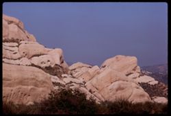
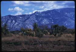
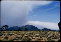
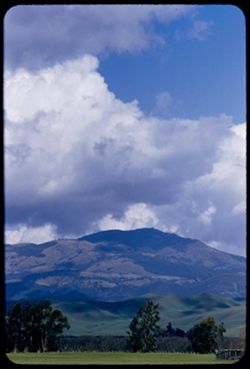
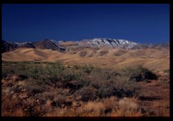
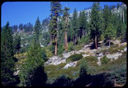
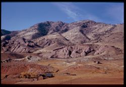
- Description:
- 100 f 9 TL
- Subject:
- Passes (Landforms), Cajon Pass (Calif.), Shrubs, Rock formations, Mountains, and Grasses
- Series:
- 3-69
- Creator:
- Cushman, Charles W., 1896-1972
- Date Created:
- 1969-03-20
- Genre:
- Landscape photographs
- Frame Number:
- 15
- County:
- San Bernardino
- Abstract:
- In Cajon Pass
- Call Number:
- P15767
- Country:
- United States
- State/Province:
- California
- Alternate Identifier:
- 369.15
- Persistent URL:
- http://purl.dlib.indiana.edu/iudl/archives/cushman/P15767
- Holding Location:
- Bloomington - University Archives
Wells Library E460
1320 E 10th St.
Bloomington, IN 47405
Contact at archives@indiana.edu, 812-855-1127
-
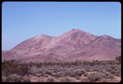
- Description:
- 100 f 9 TL
- Subject:
- Trees, Mountains, Shrubs, and Hills
- Series:
- 2-69
- Creator:
- Cushman, Charles W., 1896-1972
- Date Created:
- 1969-03-14
- Genre:
- Landscape photographs
- Frame Number:
- 15
- Street Address:
- California State Highway 14
- County:
- Kern
- Abstract:
- Views NW from Hwy 14 south of Mojave
- Call Number:
- P15732
- City:
- Mojave
- Country:
- United States
- State/Province:
- California
- Alternate Identifier:
- 269.15
- Persistent URL:
- http://purl.dlib.indiana.edu/iudl/archives/cushman/P15732
- Holding Location:
- Bloomington - University Archives
Wells Library E460
1320 E 10th St.
Bloomington, IN 47405
Contact at archives@indiana.edu, 812-855-1127
-
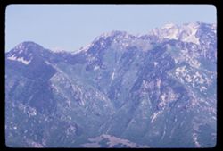
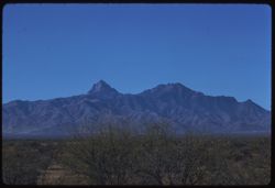
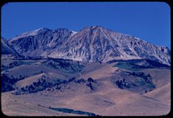
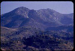
- Description:
- 100 f 11 TL
- Subject:
- Wasatch Range (Utah and Idaho) and Mountains
- Series:
- 10-66
- Creator:
- Cushman, Charles W., 1896-1972
- Date Created:
- 1966-06-19
- Genre:
- Landscape photographs
- Frame Number:
- 15
- County:
- Salt Lake
- Abstract:
- Wasatch Mts.
- Call Number:
- P15455
- City:
- Salt Lake City
- Country:
- United States
- State/Province:
- Utah
- Alternate Identifier:
- 1066.15
- Persistent URL:
- http://purl.dlib.indiana.edu/iudl/archives/cushman/P15455
- Holding Location:
- Bloomington - University Archives
Wells Library E460
1320 E 10th St.
Bloomington, IN 47405
Contact at archives@indiana.edu, 812-855-1127
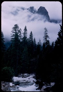
-
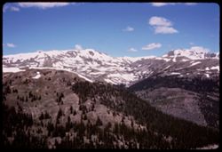
- Subject:
- Passes (Landforms), Forests, Mountains, Snow, Trees, Clouds, and Loveland Pass (Colo.)
- Series:
- 9-66
- Creator:
- Cushman, Charles W., 1896-1972
- Date Created:
- 1966-06-14
- Genre:
- Landscape photographs
- Frame Number:
- 15
- County:
- Larimer
- Call Number:
- P15418
- Country:
- United States
- State/Province:
- Colorado
- Alternate Identifier:
- 966.15
- Persistent URL:
- http://purl.dlib.indiana.edu/iudl/archives/cushman/P15418
- Holding Location:
- Bloomington - University Archives
Wells Library E460
1320 E 10th St.
Bloomington, IN 47405
Contact at archives@indiana.edu, 812-855-1127
-
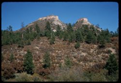
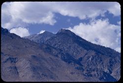
- Description:
- 100 f 13 sl
- Subject:
- Trees, Mountains, Rock formations, and Shrubs
- Series:
- 34-65
- Creator:
- Cushman, Charles W., 1896-1972
- Date Created:
- 1965-10-03
- Genre:
- Landscape photographs
- Frame Number:
- 15
- County:
- La Plata
- Abstract:
- 2 truncated pyramids w. of Durango
- Call Number:
- P15007
- City:
- Durango
- Country:
- United States
- State/Province:
- Colorado
- Alternate Identifier:
- 3465.15
- Persistent URL:
- http://purl.dlib.indiana.edu/iudl/archives/cushman/P15007
- Holding Location:
- Bloomington - University Archives
Wells Library E460
1320 E 10th St.
Bloomington, IN 47405
Contact at archives@indiana.edu, 812-855-1127
-
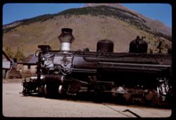
- Description:
- 100 f 11
- Subject:
- Grocery stores, Houses, Railroad locomotives, Mountains, Denver and Rio Grande Western Railway Company, Fences, and Buildings
- Series:
- 33-65
- Creator:
- Cushman, Charles W., 1896-1972
- Date Created:
- 1965-10-02
- Genre:
- Identification photographs
- Frame Number:
- 15
- County:
- San Juan
- Abstract:
- Rio Grande old train
- Call Number:
- P14970
- City:
- Silverton
- Country:
- United States
- State/Province:
- Colorado
- Alternate Identifier:
- 3365.15
- Persistent URL:
- http://purl.dlib.indiana.edu/iudl/archives/cushman/P14970
- Holding Location:
- Bloomington - University Archives
Wells Library E460
1320 E 10th St.
Bloomington, IN 47405
Contact at archives@indiana.edu, 812-855-1127
-
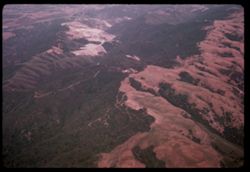
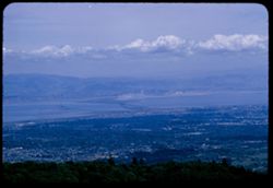
- Subject:
- Valleys, Mountains, Air travel, Forests, and Hills
- Series:
- 26-65
- Creator:
- Cushman, Charles W., 1896-1972
- Date Created:
- 1965-06-02
- Genre:
- Aerial photographs and Landscape photographs
- Frame Number:
- 15
- Call Number:
- P14776
- Country:
- United States
- Alternate Identifier:
- 2665.15
- Persistent URL:
- http://purl.dlib.indiana.edu/iudl/archives/cushman/P14776
- Holding Location:
- Bloomington - University Archives
Wells Library E460
1320 E 10th St.
Bloomington, IN 47405
Contact at archives@indiana.edu, 812-855-1127
-
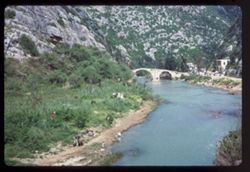
- Subject:
- Nahr al-Kalb (Lebanon), Grasses, Trees, Coastlines, Children playing in water, Arches, Mountains, Refugees, Bridges, Mules, and Rivers
- Series:
- 16-65
- Creator:
- Cushman, Charles W., 1896-1972
- Date Created:
- 1965-05-02
- Genre:
- Landscape photographs and Ethnographic photographs
- Frame Number:
- 15
- Abstract:
- Arab refugees on Dog river
- Call Number:
- P14404
- City:
- Jubayl
- Country:
- Lebanon
- State/Province:
- Jabal Lubnan
- Alternate Identifier:
- 1665.15
- Persistent URL:
- http://purl.dlib.indiana.edu/iudl/archives/cushman/P14404
- Holding Location:
- Bloomington - University Archives
Wells Library E460
1320 E 10th St.
Bloomington, IN 47405
Contact at archives@indiana.edu, 812-855-1127
-
- Subject:
- Walls, Archaeological sites, Parthenon (Athens, Greece), Colonnades, Odeion of Herodes Atticus (Athens, Greece), Greek temples, Cities & towns, Pediments...
- Series:
- 15-65
- Creator:
- Cushman, Charles W., 1896-1972
- Date Created:
- 1965-04-29
- Genre:
- Cityscape photographs
- Frame Number:
- 15
- County:
- Attica
- Abstract:
- Acropolis from height of Philopappos
- Call Number:
- P14366
- City:
- Athens
- Country:
- Greece
- State/Province:
- Central Greece and Euboea
- Alternate Identifier:
- 1565.15
- Persistent URL:
- http://purl.dlib.indiana.edu/iudl/archives/cushman/P14366
- Holding Location:
- Bloomington - University Archives
Wells Library E460
1320 E 10th St.
Bloomington, IN 47405
Contact at archives@indiana.edu, 812-855-1127
-
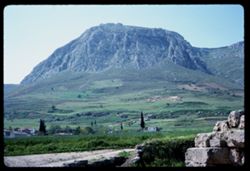
- Subject:
- Valleys, Dirt roads, Trees, Meadows, Mountains, Hills, and Archaeological sites
- Series:
- 14-65
- Creator:
- Cushman, Charles W., 1896-1972
- Date Created:
- 1965-04-28
- Genre:
- Landscape photographs
- Frame Number:
- 15
- County:
- Corinth
- Abstract:
- Old Corinth
- Call Number:
- P14329
- City:
- Corinth
- Country:
- Greece
- State/Province:
- Peloponnese
- Alternate Identifier:
- 1465.15
- Persistent URL:
- http://purl.dlib.indiana.edu/iudl/archives/cushman/P14329
- Holding Location:
- Bloomington - University Archives
Wells Library E460
1320 E 10th St.
Bloomington, IN 47405
Contact at archives@indiana.edu, 812-855-1127
-
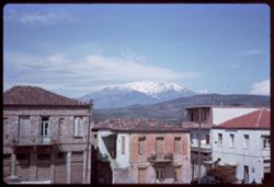
- Description:
- 100 f 13
- Subject:
- Snow, Balconies, Roofs, Stairways, Mountains, Windows, Dwellings, Hills, Parnassus, Mount (Greece), and Doors & doorways
- Series:
- 11-65
- Creator:
- Cushman, Charles W., 1896-1972
- Date Created:
- 1965-04-21
- Genre:
- Landscape photographs and Cityscape photographs
- Frame Number:
- 15
- County:
- Boeotia
- Abstract:
- Levadhia
- Call Number:
- P14216
- City:
- Levadhia
- Country:
- Greece
- State/Province:
- Central Greece and Euboea
- Alternate Identifier:
- 1165.15
- Persistent URL:
- http://purl.dlib.indiana.edu/iudl/archives/cushman/P14216
- Holding Location:
- Bloomington - University Archives
Wells Library E460
1320 E 10th St.
Bloomington, IN 47405
Contact at archives@indiana.edu, 812-855-1127
-
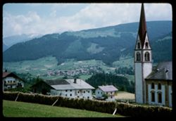
- Description:
- 200 f 8
- Subject:
- Roofs, Churches, Valleys, Hills, Stubay Valley (Austria), Mountains, Railroad travel, Bell towers, Fences, Cities & towns, and Spires
- Series:
- 17-64
- Creator:
- Cushman, Charles W., 1896-1972
- Date Created:
- 1964-06-09
- Genre:
- Landscape photographs and Cityscape photographs
- Frame Number:
- 15
- Abstract:
- Church at Telfes
- Call Number:
- P13556
- City:
- Telfes
- Country:
- Austria
- State/Province:
- Tyrol
- Alternate Identifier:
- 1764.15
- Persistent URL:
- http://purl.dlib.indiana.edu/iudl/archives/cushman/P13556
- Holding Location:
- Bloomington - University Archives
Wells Library E460
1320 E 10th St.
Bloomington, IN 47405
Contact at archives@indiana.edu, 812-855-1127
-
- Description:
- 100 f 11
- Subject:
- Snow, Valleys, Trees, Croplands, Forests, Patscherkofel (Austria), and Mountains
- Series:
- 15-64
- Creator:
- Cushman, Charles W., 1896-1972
- Date Created:
- 1964-06-04
- Genre:
- Landscape photographs and Cityscape photographs
- Frame Number:
- 15
- Abstract:
- From Patscherkofel
- Call Number:
- P13480
- City:
- Innsbruck
- Country:
- Austria
- State/Province:
- Tyrol
- Alternate Identifier:
- 1564.15
- Persistent URL:
- http://purl.dlib.indiana.edu/iudl/archives/cushman/P13480
- Holding Location:
- Bloomington - University Archives
Wells Library E460
1320 E 10th St.
Bloomington, IN 47405
Contact at archives@indiana.edu, 812-855-1127
-
- Description:
- 100 f 11
- Subject:
- Automobiles, Streets, Cupolas, Mountains, Buildings, Clouds, Steeples, Clocks & watches, Clock towers, and Arcades (Architectural components)
- Series:
- 14-64
- Creator:
- Cushman, Charles W., 1896-1972
- Date Created:
- 1964-06-03
- Genre:
- Cityscape photographs and Architectural photographs
- Frame Number:
- 15
- Street Address:
- Maria Theresienstrasse
- Abstract:
- Clock tower of Maria Theres Str.
- Call Number:
- P13443
- City:
- Innsbruck
- Country:
- Austria
- State/Province:
- Tyrol
- Alternate Identifier:
- 1464.15
- Persistent URL:
- http://purl.dlib.indiana.edu/iudl/archives/cushman/P13443
- Holding Location:
- Bloomington - University Archives
Wells Library E460
1320 E 10th St.
Bloomington, IN 47405
Contact at archives@indiana.edu, 812-855-1127
-
- Description:
- 100 f 11
- Subject:
- Bell towers, Trees, Flowers, Cupolas, Mountains, Churches, Clouds, Steeples, Alps, Austrian (Austria), Utility poles, Spires, and Fences
- Series:
- 16-64
- Creator:
- Cushman, Charles W., 1896-1972
- Date Created:
- 1964-06-05
- Genre:
- Landscape photographs and Cityscape photographs
- Frame Number:
- 15
- Abstract:
- Mts behind Solbad
- Call Number:
- P13518
- City:
- Solbad Hall
- Country:
- Austria
- State/Province:
- Tyrol
- Alternate Identifier:
- 1664.15
- Persistent URL:
- http://purl.dlib.indiana.edu/iudl/archives/cushman/P13518
- Holding Location:
- Bloomington - University Archives
Wells Library E460
1320 E 10th St.
Bloomington, IN 47405
Contact at archives@indiana.edu, 812-855-1127
-
- Description:
- 100 f 5.6 *
- Subject:
- Clock towers, Spires, Salzach River (Austria and Germany), Mountains, Waterfronts, Dwellings, Trees, Buildings, Bell towers, Rivers, and Churches
- Series:
- 12-64
- Creator:
- Cushman, Charles W., 1896-1972
- Date Created:
- 1964-05-30
- Genre:
- Cityscape photographs
- Frame Number:
- 15
- Abstract:
- Evangelische Kirche from Monchsberg
- Call Number:
- P13368
- City:
- Salzburg
- Country:
- Austria
- State/Province:
- Salzburg
- Alternate Identifier:
- 1264.15
- Persistent URL:
- http://purl.dlib.indiana.edu/iudl/archives/cushman/P13368
- Holding Location:
- Bloomington - University Archives
Wells Library E460
1320 E 10th St.
Bloomington, IN 47405
Contact at archives@indiana.edu, 812-855-1127
-

- Description:
- 50 f 11
- Subject:
- Spires, Kapuzinerberg (Salzburg, Austria), Gates, Mountains, Mothers & children, Cobblestone streets, Stairways, Shrines, and Arches
- Series:
- 11-64
- Creator:
- Cushman, Charles W., 1896-1972
- Date Created:
- 1964-05-27
- Genre:
- Views
- Frame Number:
- 15
- Abstract:
- Steps up Kapuzinerberg
- Call Number:
- P13330
- City:
- Salzburg
- Country:
- Austria
- State/Province:
- Salzburg
- Alternate Identifier:
- 1164.15
- Persistent URL:
- http://purl.dlib.indiana.edu/iudl/archives/cushman/P13330
- Holding Location:
- Bloomington - University Archives
Wells Library E460
1320 E 10th St.
Bloomington, IN 47405
Contact at archives@indiana.edu, 812-855-1127
-
- Subject:
- Snow, Königssee (Germany : Lake), Coastlines, Watzmann (Germany), Mountains, Lakes & ponds, and Forests
- Series:
- 10-64
- Creator:
- Cushman, Charles W., 1896-1972
- Date Created:
- 1964-05-25
- Genre:
- Landscape photographs
- Frame Number:
- 15
- County:
- Oberbayern
- Abstract:
- Toward [der Wachtmann] Watzmann
- Call Number:
- P13292
- City:
- Berchtesgaden
- Country:
- Germany
- State/Province:
- Bavaria
- Alternate Identifier:
- 1064.15
- Persistent URL:
- http://purl.dlib.indiana.edu/iudl/archives/cushman/P13292
- Holding Location:
- Bloomington - University Archives
Wells Library E460
1320 E 10th St.
Bloomington, IN 47405
Contact at archives@indiana.edu, 812-855-1127
-
- Description:
- 100 f 8
- Subject:
- Snow, Untersberg (Austria), Salzach River (Austria and Germany), Cliffs, Cable railroads, Mountains, Shrubs, Forests, Rivers, and Rock formations
- Series:
- 9-64
- Creator:
- Cushman, Charles W., 1896-1972
- Date Created:
- 1964-05-24
- Genre:
- Landscape photographs, Views, and Cityscape photographs
- Frame Number:
- 15
- Abstract:
- On Untersberg Looking down to right of cables
- Call Number:
- P13255
- City:
- Salzburg
- Country:
- Austria
- State/Province:
- Salzburg
- Alternate Identifier:
- 964.15
- Persistent URL:
- http://purl.dlib.indiana.edu/iudl/archives/cushman/P13255
- Holding Location:
- Bloomington - University Archives
Wells Library E460
1320 E 10th St.
Bloomington, IN 47405
Contact at archives@indiana.edu, 812-855-1127
-
- Description:
- 100 f 11TL
- Subject:
- Grasses, Mountains, Rock formations, Hills, and Rivers
- Series:
- 6-63
- Creator:
- Cushman, Charles W., 1896-1972
- Date Created:
- 1963-06-28
- Genre:
- Landscape photographs
- Frame Number:
- 15
- County:
- San Bernardino
- Abstract:
- The Needles near Needles Calif
- Call Number:
- P12968
- City:
- Needles
- Country:
- United States
- State/Province:
- California
- Alternate Identifier:
- 663.15
- Persistent URL:
- http://purl.dlib.indiana.edu/iudl/archives/cushman/P12968
- Holding Location:
- Bloomington - University Archives
Wells Library E460
1320 E 10th St.
Bloomington, IN 47405
Contact at archives@indiana.edu, 812-855-1127
-
- Description:
- 100 f 13 ?
- Subject:
- Cliffs, Cactus, Trees, Mountains, Shrubs, and Hills
- Series:
- 5-62
- Creator:
- Cushman, Charles W., 1896-1972
- Date Created:
- 1962-10-05
- Genre:
- Landscape photographs
- Frame Number:
- 15
- County:
- Coconino
- Abstract:
- East from 6 or 7 mi west of Sedona
- Call Number:
- P12782
- City:
- Sedona
- Country:
- United States
- State/Province:
- Arizona
- Alternate Identifier:
- 562.15
- Persistent URL:
- http://purl.dlib.indiana.edu/iudl/archives/cushman/P12782
- Holding Location:
- Bloomington - University Archives
Wells Library E460
1320 E 10th St.
Bloomington, IN 47405
Contact at archives@indiana.edu, 812-855-1127
-
- Description:
- 100 f 4 TL
- Subject:
- Storms, Lakes & ponds, Rain, Tahoe, Lake (Calif. and Nev.), Mountains, and Clouds
- Series:
- 3-62
- Creator:
- Cushman, Charles W., 1896-1972
- Date Created:
- 1962-09-28
- Genre:
- Landscape photographs and Snapshots
- Frame Number:
- 15
- Abstract:
- Gathering storm. Lake Tahoe.
- Call Number:
- P12713
- Country:
- United States
- State/Province:
- California
- Alternate Identifier:
- 362.15
- Persistent URL:
- http://purl.dlib.indiana.edu/iudl/archives/cushman/P12713
- Holding Location:
- Bloomington - University Archives
Wells Library E460
1320 E 10th St.
Bloomington, IN 47405
Contact at archives@indiana.edu, 812-855-1127
-
- Description:
- 100 f 5.6 TL HF
- Subject:
- Sightseers, Valleys, Ethnic groups, Automobiles, Binoculars, Mountains, Coachella Valley (Calif.), People, Families, San Jacinto Mountains (Calif.), and Shrubs
- Series:
- 24-61
- Creator:
- Cushman, Charles W., 1896-1972
- Date Created:
- 1961-12-27
- Genre:
- Landscape photographs and Ethnographic photographs
- Frame Number:
- 15
- County:
- Riverside
- Abstract:
- Mexicans - Elisabeta, Tacho et al and Group of Mexicans- Elisabeta, Tacho, [etal]
- Call Number:
- P12581
- Country:
- United States
- State/Province:
- California
- Alternate Identifier:
- 2461.15
- Persistent URL:
- http://purl.dlib.indiana.edu/iudl/archives/cushman/P12581
- Holding Location:
- Bloomington - University Archives
Wells Library E460
1320 E 10th St.
Bloomington, IN 47405
Contact at archives@indiana.edu, 812-855-1127
-
- Description:
- 100 f 8 tl
- Subject:
- Saint Helens, Mount (Wash.), Cities & towns, Streets, Mountains, Utility poles, Snow, Commercial facilities, Portland Electric & Plumbing Company (Po...
- Series:
- 25-60
- Creator:
- Cushman, Charles W., 1896-1972
- Date Created:
- 1960-09-25
- Genre:
- Cityscape photographs
- Frame Number:
- 15
- County:
- Multnomah
- Abstract:
- Toward Mt St Helens
- Call Number:
- P11703
- City:
- Portland
- Country:
- United States
- State/Province:
- Oregon
- Alternate Identifier:
- 2560.15
- Persistent URL:
- http://purl.dlib.indiana.edu/iudl/archives/cushman/P11703
- Holding Location:
- Bloomington - University Archives
Wells Library E460
1320 E 10th St.
Bloomington, IN 47405
Contact at archives@indiana.edu, 812-855-1127
-
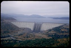
- Description:
- 100 f 8 sl
- Subject:
- Reservoirs, Columbia River bridge (Wasco County, Or.), Mountains, Clouds, Railroad tracks, Hills, Dams, Rivers, Columbia River, Bridges, and Dalles Dam (Or. ...
- Series:
- 24-60
- Creator:
- Cushman, Charles W., 1896-1972
- Date Created:
- 1960-09-19
- Genre:
- Views
- Frame Number:
- 15
- County:
- Wasco
- Abstract:
- Columbia river bridge alongside Dalles Dam
- Call Number:
- P11669
- City:
- Dalles
- Country:
- United States
- State/Province:
- Oregon
- Alternate Identifier:
- 2460.15
- Persistent URL:
- http://purl.dlib.indiana.edu/iudl/archives/cushman/P11669
- Holding Location:
- Bloomington - University Archives
Wells Library E460
1320 E 10th St.
Bloomington, IN 47405
Contact at archives@indiana.edu, 812-855-1127
-
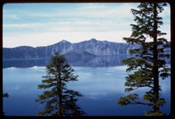
- Description:
- 50 f 6.3 sl
- Subject:
- Cliffs, Trees, Crater Lake (Or.), Tree limbs, Mountains, Lakes & ponds, Clouds, Islands, Reflections, and Kerr Notch (Or.)
- Series:
- 23-60
- Creator:
- Cushman, Charles W., 1896-1972
- Date Created:
- 1960-09-16
- Genre:
- Landscape photographs
- Frame Number:
- 15
- County:
- Klamath
- Abstract:
- Crater Lake from Kerr Notch
- Call Number:
- P11637
- Country:
- United States
- State/Province:
- Oregon
- Alternate Identifier:
- 2360.15
- Persistent URL:
- http://purl.dlib.indiana.edu/iudl/archives/cushman/P11637
- Holding Location:
- Bloomington - University Archives
Wells Library E460
1320 E 10th St.
Bloomington, IN 47405
Contact at archives@indiana.edu, 812-855-1127
-
- Description:
- 100 f 8
- Subject:
- Terraces, Houses, Mountains, Trees, Buildings, Plants, and Hills
- Series:
- 8-60
- Creator:
- Cushman, Charles W., 1896-1972
- Date Created:
- 1960-05-16
- Genre:
- Cityscape photographs
- Frame Number:
- 15
- County:
- Alpes-Maritimes
- Abstract:
- Les Tourettes
- Call Number:
- P11115
- City:
- Tourrette-sur-Loup
- Country:
- France
- State/Province:
- Provence-Alpes-Côte d'Azur
- Alternate Identifier:
- 860.15
- Persistent URL:
- http://purl.dlib.indiana.edu/iudl/archives/cushman/P11115
- Holding Location:
- Bloomington - University Archives
Wells Library E460
1320 E 10th St.
Bloomington, IN 47405
Contact at archives@indiana.edu, 812-855-1127
-
- Description:
- 100 f 9 tl
- Subject:
- Snow, San Gorgonio Mountain (Calif.), Sand, San Jacinto Peak (Calif.), Mountains, and Shrubs
- Series:
- 11-59
- Creator:
- Cushman, Charles W., 1896-1972
- Date Created:
- 1959-03-25
- Genre:
- Landscape photographs
- Frame Number:
- 15
- County:
- Riverside
- Abstract:
- RM San Jacinto mtn
- Call Number:
- P10740
- Country:
- United States
- State/Province:
- California
- Alternate Identifier:
- 1159.15
- Persistent URL:
- http://purl.dlib.indiana.edu/iudl/archives/cushman/P10740
- Holding Location:
- Bloomington - University Archives
Wells Library E460
1320 E 10th St.
Bloomington, IN 47405
Contact at archives@indiana.edu, 812-855-1127
-
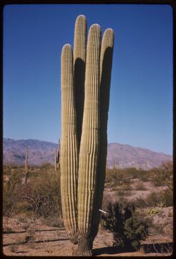
- Description:
- 50 f 11 sl
- Subject:
- Deserts, Cactus, Mountains, Shrubs, and Saguaro National Park (Ariz.)
- Series:
- 10-59
- Creator:
- Cushman, Charles W., 1896-1972
- Date Created:
- 1959-03-05
- Genre:
- Identification photographs
- Frame Number:
- 15
- County:
- Pima
- Abstract:
- A 4 in 1 Saguaro
- Call Number:
- P10703
- City:
- Tucson
- Country:
- United States
- State/Province:
- Arizona
- Alternate Identifier:
- 1059.15
- Persistent URL:
- http://purl.dlib.indiana.edu/iudl/archives/cushman/P10703
- Holding Location:
- Bloomington - University Archives
Wells Library E460
1320 E 10th St.
Bloomington, IN 47405
Contact at archives@indiana.edu, 812-855-1127
-
- Description:
- 100 f 5.6 tl
- Subject:
- Snow, Cactus, Trees, Mountains, Shrubs, Clouds, and Santa Catalina Mountains (Ariz.)
- Series:
- 7-59
- Creator:
- Cushman, Charles W., 1896-1972
- Date Created:
- 1959-02-03
- Genre:
- Landscape photographs
- Frame Number:
- 15
- County:
- Pinal
- Abstract:
- Santa Catalina Mtns
- Call Number:
- P10591
- City:
- Oracle Junction
- Country:
- United States
- State/Province:
- Arizona
- Alternate Identifier:
- 759.15
- Persistent URL:
- http://purl.dlib.indiana.edu/iudl/archives/cushman/P10591
- Holding Location:
- Bloomington - University Archives
Wells Library E460
1320 E 10th St.
Bloomington, IN 47405
Contact at archives@indiana.edu, 812-855-1127
-
- Description:
- 100 f 8 tl
- Subject:
- Baboquivari Peak (Ariz.), Mountains, and Shrubs
- Series:
- 6-59
- Creator:
- Cushman, Charles W., 1896-1972
- Date Created:
- 1959-01-28
- Genre:
- Landscape photographs
- Frame Number:
- 15
- County:
- Pima
- Abstract:
- Baboquivari from the east
- Call Number:
- P10553
- Country:
- United States
- State/Province:
- Arizona
- Alternate Identifier:
- 659.15
- Persistent URL:
- http://purl.dlib.indiana.edu/iudl/archives/cushman/P10553
- Holding Location:
- Bloomington - University Archives
Wells Library E460
1320 E 10th St.
Bloomington, IN 47405
Contact at archives@indiana.edu, 812-855-1127
-
- Description:
- 100 f 8 tl
- Subject:
- Mountains, Clouds, and Hills
- Series:
- 17-58
- Creator:
- Cushman, Charles W., 1896-1972
- Date Created:
- 1958-08-26
- Genre:
- Landscape photographs
- Frame Number:
- 15
- County:
- Carbon
- Abstract:
- Mtn north of Lamont
- Call Number:
- P10177
- City:
- Lamont
- Country:
- United States
- State/Province:
- Wyoming
- Alternate Identifier:
- 1758.15
- Persistent URL:
- http://purl.dlib.indiana.edu/iudl/archives/cushman/P10177
- Holding Location:
- Bloomington - University Archives
Wells Library E460
1320 E 10th St.
Bloomington, IN 47405
Contact at archives@indiana.edu, 812-855-1127
-
- Description:
- 50 f 11 sl
- Subject:
- Canyons, Roads, Trees, Mountains, Truckee River (Calif. and Nev.), Clouds, and Verdi Range (Calif.)
- Series:
- 15-58
- Creator:
- Cushman, Charles W., 1896-1972
- Date Created:
- 1958-08-22
- Genre:
- Landscape photographs
- Frame Number:
- 15
- County:
- Nevada and Sierra
- Abstract:
- Canyon of Truckee river between Truckee and Verdi
- Call Number:
- P10121
- City:
- Truckee
- Country:
- United States
- State/Province:
- California
- Alternate Identifier:
- 1558.15
- Persistent URL:
- http://purl.dlib.indiana.edu/iudl/archives/cushman/P10121
- Holding Location:
- Bloomington - University Archives
Wells Library E460
1320 E 10th St.
Bloomington, IN 47405
Contact at archives@indiana.edu, 812-855-1127
-
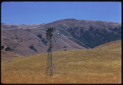
- Description:
- 100 f 6.3 TL
- Subject:
- Windmills, Meadows, Mountains, and Hills
- Series:
- 13-58
- Creator:
- Cushman, Charles W., 1896-1972
- Date Created:
- 1958-07-18
- Genre:
- Landscape photographs
- Frame Number:
- 15
- County:
- Marin
- Abstract:
- Marin ridge back of wind mill (8808.8 mi.)
- Call Number:
- P10063
- City:
- Nicasio
- Country:
- United States
- State/Province:
- California
- Alternate Identifier:
- 1358.15
- Persistent URL:
- http://purl.dlib.indiana.edu/iudl/archives/cushman/P10063
- Holding Location:
- Bloomington - University Archives
Wells Library E460
1320 E 10th St.
Bloomington, IN 47405
Contact at archives@indiana.edu, 812-855-1127
-
- Description:
- 100 f 8 tl
- Subject:
- Houses, Trees, Yards, Mountains, Fences, Roads, and Lane Mountain (Calif.)
- Series:
- 3-58
- Creator:
- Cushman, Charles W., 1896-1972
- Date Created:
- 1958-04-25
- Genre:
- Landscape photographs
- Frame Number:
- 15
- County:
- San Bernardino
- Abstract:
- From south side of town toward Lane Mtn. To north
- Call Number:
- P09731
- City:
- Barstow
- Country:
- United States
- State/Province:
- California
- Alternate Identifier:
- 358.15
- Persistent URL:
- http://purl.dlib.indiana.edu/iudl/archives/cushman/P09731
- Holding Location:
- Bloomington - University Archives
Wells Library E460
1320 E 10th St.
Bloomington, IN 47405
Contact at archives@indiana.edu, 812-855-1127
-
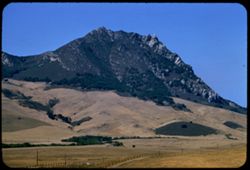
- Description:
- 100 f 6.3 tl
- Subject:
- Dirt roads, Meadows, Mountains, and Hollister Peak (Calif.)
- Series:
- 14-57
- Creator:
- Cushman, Charles W., 1896-1972
- Date Created:
- 1957-09-19
- Genre:
- Landscape photographs
- Frame Number:
- 15
- County:
- San Luis Obispo
- Abstract:
- Same from nearer
- Call Number:
- P09514
- City:
- San Luis Obispo and Morro Bay
- Country:
- United States
- State/Province:
- California
- Alternate Identifier:
- 1457.15
- Persistent URL:
- http://purl.dlib.indiana.edu/iudl/archives/cushman/P09514
- Holding Location:
- Bloomington - University Archives
Wells Library E460
1320 E 10th St.
Bloomington, IN 47405
Contact at archives@indiana.edu, 812-855-1127
-
- Description:
- 100 f 8 tl
- Subject:
- Farmhouses, Grazing, Barbed wire, Trees, Livestock, Mountains, Fences, Clouds, and Napa Valley (Calif.)
- Series:
- 10-57
- Creator:
- Cushman, Charles W., 1896-1972
- Date Created:
- 1957-07-06
- Genre:
- Landscape photographs
- Frame Number:
- 15
- Street Address:
- California State Highway 128
- County:
- Napa
- Abstract:
- Ridge at NE end of Napa Valley from 128 NW of Calistoga
- Call Number:
- P09389
- City:
- Calistoga
- Country:
- United States
- State/Province:
- California
- Alternate Identifier:
- 1057.15
- Persistent URL:
- http://purl.dlib.indiana.edu/iudl/archives/cushman/P09389
- Holding Location:
- Bloomington - University Archives
Wells Library E460
1320 E 10th St.
Bloomington, IN 47405
Contact at archives@indiana.edu, 812-855-1127
-
- Description:
- 100 f 8 tl
- Subject:
- Deserts, Mojave Desert (Calif.), Joshua trees, Plains, Mountains, Shrubs, and Clouds
- Series:
- 7-57
- Creator:
- Cushman, Charles W., 1896-1972
- Date Created:
- 1957-05-14
- Genre:
- Landscape photographs
- Frame Number:
- 15
- Street Address:
- United States Highway 6
- County:
- Kern
- Abstract:
- Mountains NW of US 6 north of Rosamond
- Call Number:
- P09294
- City:
- Rosamond
- Country:
- United States
- State/Province:
- California
- Alternate Identifier:
- 757.15
- Persistent URL:
- http://purl.dlib.indiana.edu/iudl/archives/cushman/P09294
- Holding Location:
- Bloomington - University Archives
Wells Library E460
1320 E 10th St.
Bloomington, IN 47405
Contact at archives@indiana.edu, 812-855-1127
-
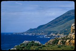
- Description:
- 100 f 6.3 tl
- Subject:
- Rocks, Oceans, Soberanes Point (Calif.), Coastlines, Pacific Ocean, Mountains, Pacific Coast (Calif.), and Garrapata Creek (Monterey County, Calif.)
- Series:
- 5-57
- Creator:
- Cushman, Charles W., 1896-1972
- Date Created:
- 1957-05-09
- Genre:
- Landscape photographs and Seascapes
- Frame Number:
- 15
- County:
- Monterey
- Abstract:
- Coast north of Garrapata Creek
- Call Number:
- P09220
- City:
- Carmel
- Country:
- United States
- State/Province:
- California
- Alternate Identifier:
- 557.15
- Persistent URL:
- http://purl.dlib.indiana.edu/iudl/archives/cushman/P09220
- Holding Location:
- Bloomington - University Archives
Wells Library E460
1320 E 10th St.
Bloomington, IN 47405
Contact at archives@indiana.edu, 812-855-1127
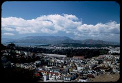
-
- Description:
- 100 f 6.3 tl telescope lens
- Subject:
- Cities & towns, Dumbarton Bridge (Calif.), San Francisco Bay (Calif.), Mountains, Clouds, Skeggs Point (Calif.), and Bays (Bodies of water)
- Series:
- 3-57
- Creator:
- Cushman, Charles W., 1896-1972
- Date Created:
- 1957-04-12
- Genre:
- Cityscape photographs
- Frame Number:
- 15
- Street Address:
- Skyline Drive and Highway 5
- County:
- San Mateo
- Abstract:
- Toward Dumbarton Br.
- Call Number:
- P09179
- Country:
- United States
- State/Province:
- California
- Alternate Identifier:
- 357.15
- Persistent URL:
- http://purl.dlib.indiana.edu/iudl/archives/cushman/P09179
- Holding Location:
- Bloomington - University Archives
Wells Library E460
1320 E 10th St.
Bloomington, IN 47405
Contact at archives@indiana.edu, 812-855-1127
-
- Description:
- 100 f 8 tl
- Subject:
- Valleys, Meadows, Saint Helena, Mount (Calif.), Mountains, Forests, and Hills
- Series:
- 2-57
- Creator:
- Cushman, Charles W., 1896-1972
- Date Created:
- 1957-04-02
- Genre:
- Landscape photographs
- Frame Number:
- 15
- Street Address:
- United States Highway 128
- County:
- Sonoma
- Abstract:
- High west hump of Mt. St. Helena from Hwy. 128
- Call Number:
- P09141
- Country:
- United States
- State/Province:
- California
- Alternate Identifier:
- 257.15
- Persistent URL:
- http://purl.dlib.indiana.edu/iudl/archives/cushman/P09141
- Holding Location:
- Bloomington - University Archives
Wells Library E460
1320 E 10th St.
Bloomington, IN 47405
Contact at archives@indiana.edu, 812-855-1127
-
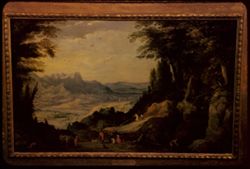
- Description:
- 25 f 3.5
- Subject:
- Valleys, Mountain landscape, Trees, Fine Arts Museums of San Francisco, M. H. De Young Memorial Museum, Mountains, Picture frames, People, Animals, and Rivers
- Series:
- 12-56
- Creator:
- Cushman, Charles W., 1896-1972
- Date Created:
- 1956-08-02
- Genre:
- Reproductions and Landscape paintings
- Frame Number:
- 15
- County:
- San Francisco
- Persons Pictured:
- Momper, Josse de, 1564-1635
- Abstract:
- Joos de Momper ( Flem. 1564-1635) Mountain Landscape and Joos de Momper ( Flem. 1564-1635) Recent Ac. Mountain Landscape
- Call Number:
- P08950
- City:
- San Francisco
- Country:
- United States
- State/Province:
- California
- Alternate Identifier:
- 1256.15
- Persistent URL:
- http://purl.dlib.indiana.edu/iudl/archives/cushman/P08950
- Holding Location:
- Bloomington - University Archives
Wells Library E460
1320 E 10th St.
Bloomington, IN 47405
Contact at archives@indiana.edu, 812-855-1127
-
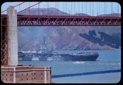
- Description:
- 100 f 5.6 tl
- Subject:
- Bays (Bodies of water), Golden Gate Bridge (San Francisco, Calif.), Suspension bridges, Coastlines, Mountains, Buildings, USS Bon Homme Richard, Aircraft car...
- Series:
- 7-56
- Creator:
- Cushman, Charles W., 1896-1972
- Date Created:
- 1956-06-08
- Genre:
- Marine photographs
- Frame Number:
- 15
- County:
- San Francisco
- Abstract:
- Carrier under GG Bridge
- Call Number:
- P08762
- City:
- San Francisco
- Country:
- United States
- State/Province:
- California
- Alternate Identifier:
- 756.15
- Persistent URL:
- http://purl.dlib.indiana.edu/iudl/archives/cushman/P08762
- Holding Location:
- Bloomington - University Archives
Wells Library E460
1320 E 10th St.
Bloomington, IN 47405
Contact at archives@indiana.edu, 812-855-1127
-
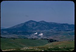
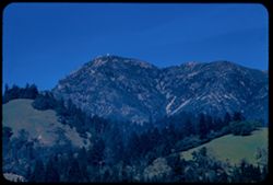
- Description:
- 100 f 8 TL
- Subject:
- Mountains and Hills
- Series:
- 6-56
- Creator:
- Cushman, Charles W., 1896-1972
- Date Created:
- 1956-04-22
- Genre:
- Landscape photographs
- Frame Number:
- 15
- Street Address:
- Bitterwater Road
- County:
- San Benito
- Abstract:
- View west across San Benito green uplands toward dark mtn ridge
- Call Number:
- P08724
- City:
- King City
- Country:
- United States
- State/Province:
- California
- Alternate Identifier:
- 656.15
- Persistent URL:
- http://purl.dlib.indiana.edu/iudl/archives/cushman/P08724
- Holding Location:
- Bloomington - University Archives
Wells Library E460
1320 E 10th St.
Bloomington, IN 47405
Contact at archives@indiana.edu, 812-855-1127
-
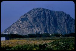
- Description:
- 100 f 8 tl
- Subject:
- Rock formations, Mountains, Plants, Morro Rock (Calif.), and Flowers
- Series:
- 4-56
- Creator:
- Cushman, Charles W., 1896-1972
- Date Created:
- 1956-04-19
- Genre:
- Landscape photographs
- Frame Number:
- 15
- County:
- San Luis Obispo
- Abstract:
- Morro Rock
- Call Number:
- P08654
- Country:
- United States
- State/Province:
- California
- Alternate Identifier:
- 456.15
- Persistent URL:
- http://purl.dlib.indiana.edu/iudl/archives/cushman/P08654
- Holding Location:
- Bloomington - University Archives
Wells Library E460
1320 E 10th St.
Bloomington, IN 47405
Contact at archives@indiana.edu, 812-855-1127
-
- Description:
- 50 mm lens
- Subject:
- Trees, Meadows, Mountains, Clouds, Hills, and Diablo, Mount (Calif.)
- Series:
- 1-56
- Creator:
- Cushman, Charles W., 1896-1972
- Date Created:
- 1956-02-23
- Genre:
- Landscape photographs
- Frame Number:
- 15
- Street Address:
- Norris Canyon Road
- County:
- Contra Costa
- Abstract:
- Mt. Diablo [P]
- Call Number:
- P08544
- Country:
- United States
- State/Province:
- California
- Alternate Identifier:
- 156.15
- Persistent URL:
- http://purl.dlib.indiana.edu/iudl/archives/cushman/P08544
- Holding Location:
- Bloomington - University Archives
Wells Library E460
1320 E 10th St.
Bloomington, IN 47405
Contact at archives@indiana.edu, 812-855-1127
-
- Description:
- 100 f 8 tl
- Subject:
- Tioga Peak (Calif.), Hills, Mountains, and Trees
- Series:
- 27-55
- Creator:
- Cushman, Charles W., 1896-1972
- Date Created:
- 1955-09-26
- Genre:
- Landscape photographs
- Frame Number:
- 15
- Street Address:
- United States Highway 395
- County:
- Mono
- Abstract:
- Toward Tioga from US395 - 5 mi so. of Leevining
- Call Number:
- P08435
- City:
- Lee Vining
- Country:
- United States
- State/Province:
- California
- Alternate Identifier:
- 2755.15
- Persistent URL:
- http://purl.dlib.indiana.edu/iudl/archives/cushman/P08435
- Holding Location:
- Bloomington - University Archives
Wells Library E460
1320 E 10th St.
Bloomington, IN 47405
Contact at archives@indiana.edu, 812-855-1127
-
- Description:
- 100 f 6.3 tl
- Subject:
- Mountains, Clouds, and Sierra Nevada (Calif. and Nev.)
- Series:
- 26-55
- Creator:
- Cushman, Charles W., 1896-1972
- Date Created:
- 1955-09-25
- Genre:
- Landscape photographs
- Frame Number:
- 15
- Street Address:
- United States Highway 6 and United States Highway 395
- County:
- Inyo
- Abstract:
- From US 6/395 between Independence & Big Pine - toward a [push?] in the high Sierra
- Call Number:
- P08398
- City:
- Big Pine and Independence
- Country:
- United States
- State/Province:
- California
- Alternate Identifier:
- 2655.15
- Persistent URL:
- http://purl.dlib.indiana.edu/iudl/archives/cushman/P08398
- Holding Location:
- Bloomington - University Archives
Wells Library E460
1320 E 10th St.
Bloomington, IN 47405
Contact at archives@indiana.edu, 812-855-1127
-
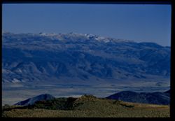
- Description:
- 100 f 6.3 TL
- Subject:
- Mountains, Antelope Valley (Calif.), Mounds (Landforms), Monitor Pass (Calif.), Sweetwater Mountains (Calif. and Nev.), and Land
- Series:
- 25-55
- Creator:
- Cushman, Charles W., 1896-1972
- Date Created:
- 1955-09-24
- Genre:
- Landscape photographs
- Frame Number:
- 15
- Street Address:
- California State Highway 89
- County:
- Mono and Alpine
- Abstract:
- From same pt. SE
- Call Number:
- P08363
- City:
- Coleville
- Country:
- United States
- State/Province:
- California
- Physical Description:
- Image was originally mounted in a glass enclosure. Before digitization, the image was removed and placed in a Wess Plastic, Inc. brand, 2" x 2", pl...
- Alternate Identifier:
- 2555.15
- Persistent URL:
- http://purl.dlib.indiana.edu/iudl/archives/cushman/P08363
- Holding Location:
- Bloomington - University Archives
Wells Library E460
1320 E 10th St.
Bloomington, IN 47405
Contact at archives@indiana.edu, 812-855-1127
-
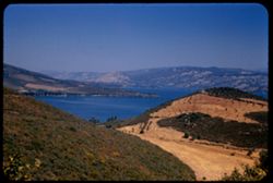
- Description:
- 100 f 5.6 SL
- Subject:
- Mountains, Lakes & ponds, Hills, Clear Lake (Lake County, Calif.), and Plants
- Series:
- 24-55
- Creator:
- Cushman, Charles W., 1896-1972
- Date Created:
- 1955-08-11
- Genre:
- Landscape photographs
- Frame Number:
- 15
- County:
- Lake
- Abstract:
- View north from same point
- Call Number:
- P08324
- City:
- Lower Lake
- Country:
- United States
- State/Province:
- California
- Alternate Identifier:
- 2455.15
- Persistent URL:
- http://purl.dlib.indiana.edu/iudl/archives/cushman/P08324
- Holding Location:
- Bloomington - University Archives
Wells Library E460
1320 E 10th St.
Bloomington, IN 47405
Contact at archives@indiana.edu, 812-855-1127
-
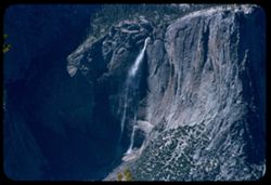
- Description:
- 100 f 5.6 tl
- Subject:
- Yosemite Falls (Calif.), Waterfalls, Trees, Half Dome (Calif.), Yosemite Point (Calif.), Mountains, and Shrubs
- Series:
- 20-55
- Creator:
- Cushman, Charles W., 1896-1972
- Date Created:
- 1955-07-07
- Genre:
- Landscape photographs
- Frame Number:
- 15
- County:
- Mariposa
- Abstract:
- Yosemite Falls
- Call Number:
- P08198
- Country:
- United States
- State/Province:
- California
- Alternate Identifier:
- 2055.15
- Persistent URL:
- http://purl.dlib.indiana.edu/iudl/archives/cushman/P08198
- Holding Location:
- Bloomington - University Archives
Wells Library E460
1320 E 10th St.
Bloomington, IN 47405
Contact at archives@indiana.edu, 812-855-1127
-
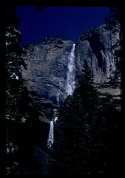
- Description:
- 100 f 6.3 50 mm
- Subject:
- Yosemite Falls (Calif.), Upper Yosemite Fall (Calif.), Mountains, Waterfalls, and Trees
- Series:
- 19-55
- Creator:
- Cushman, Charles W., 1896-1972
- Date Created:
- 1955-07-07
- Genre:
- Landscape photographs
- Frame Number:
- 15
- County:
- Mariposa
- Abstract:
- Yosemite Falls from below
- Call Number:
- P08167
- Country:
- United States
- State/Province:
- California
- Physical Description:
- Image was originally mounted in a glass enclosure. Before digitization, the image was removed and placed in a Wess Plastic, Inc. brand, 2" x 2", pl...
- Alternate Identifier:
- 1955.15
- Persistent URL:
- http://purl.dlib.indiana.edu/iudl/archives/cushman/P08167
- Holding Location:
- Bloomington - University Archives
Wells Library E460
1320 E 10th St.
Bloomington, IN 47405
Contact at archives@indiana.edu, 812-855-1127
-
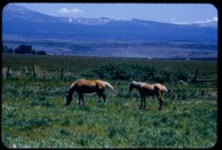
- Description:
- 100 f 6.3 tl
- Subject:
- Horses, Mountains, Shrubs, Snow, Trees, Grazing, Grasses, Fences, and Clouds
- Series:
- 18-55
- Creator:
- Cushman, Charles W., 1896-1972
- Date Created:
- 1955-06-18
- Genre:
- Identification photographs
- Frame Number:
- 15
- County:
- Modoc
- Abstract:
- Blond horses 3.3 mi south of Alturas
- Call Number:
- P08132
- City:
- Alturas
- Country:
- United States
- State/Province:
- California
- Alternate Identifier:
- 1855.15
- Persistent URL:
- http://purl.dlib.indiana.edu/iudl/archives/cushman/P08132
- Holding Location:
- Bloomington - University Archives
Wells Library E460
1320 E 10th St.
Bloomington, IN 47405
Contact at archives@indiana.edu, 812-855-1127
-
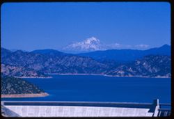
- Description:
- 100 f 7+ tl
- Subject:
- Shasta Dam (Calif.), Mountains, Shasta, Mount (Calif. : Mountain), Trees, Shrubs, Lakes & ponds, Shasta Lake (Calif.), Dams, and Fog
- Series:
- 17-55
- Creator:
- Cushman, Charles W., 1896-1972
- Date Created:
- 1955-06-16
- Genre:
- Landscape photographs
- Frame Number:
- 15
- County:
- Shasta
- Abstract:
- Mt Shasta from Shasta dam
- Call Number:
- P08095
- Country:
- United States
- State/Province:
- California
- Alternate Identifier:
- 1755.15
- Persistent URL:
- http://purl.dlib.indiana.edu/iudl/archives/cushman/P08095
- Holding Location:
- Bloomington - University Archives
Wells Library E460
1320 E 10th St.
Bloomington, IN 47405
Contact at archives@indiana.edu, 812-855-1127
-
- Description:
- 100 f 6 tl
- Subject:
- Croplands, Hills, Saint Helena, Mount (Calif.), Mountains, Shrubs, Trees, Plants, and Clouds
- Series:
- 15-55
- Creator:
- Cushman, Charles W., 1896-1972
- Date Created:
- 1955-05-17
- Genre:
- Landscape photographs
- Frame Number:
- 15
- Street Address:
- California State Highway 29
- County:
- Napa
- Abstract:
- Mt. St Helena from Hwy. 29 4 mi. so. of Calistoga
- Call Number:
- P08023
- City:
- Calistoga
- Country:
- United States
- State/Province:
- California
- Alternate Identifier:
- 1555.15
- Persistent URL:
- http://purl.dlib.indiana.edu/iudl/archives/cushman/P08023
- Holding Location:
- Bloomington - University Archives
Wells Library E460
1320 E 10th St.
Bloomington, IN 47405
Contact at archives@indiana.edu, 812-855-1127
-
- Description:
- 100 f 5.6 tl
- Subject:
- Rocks, Tehachapi Mountains (Calif.), Trees, Mountains, Shrubs, South Pacific Loop, Utility poles, Railroads, and Southern Pacific Railroad Company
- Series:
- 12-55
- Creator:
- Cushman, Charles W., 1896-1972
- Date Created:
- 1955-03-24
- Genre:
- Landscape photographs
- Frame Number:
- 15
- County:
- Kern
- Persons Pictured:
- Hood, William
- Abstract:
- Mountain above famous Sou. Pac. loop in the Tehachapi built in 1876 by Wm Hood
- Call Number:
- P07911
- Country:
- United States
- State/Province:
- California
- Alternate Identifier:
- 1255.15
- Persistent URL:
- http://purl.dlib.indiana.edu/iudl/archives/cushman/P07911
- Holding Location:
- Bloomington - University Archives
Wells Library E460
1320 E 10th St.
Bloomington, IN 47405
Contact at archives@indiana.edu, 812-855-1127
-
- Description:
- 100 f 8 tl
- Subject:
- Snow, Valleys, Mountains, and Death Valley National Park (Calif. and Nev.)
- Series:
- 10-55
- Creator:
- Cushman, Charles W., 1896-1972
- Date Created:
- 1955-03-22
- Genre:
- Landscape photographs
- Frame Number:
- 15
- Street Address:
- Bad Water Road
- County:
- Inyo
- Abstract:
- Streaks down the chocolate ice cream from Bad Water road
- Call Number:
- P07840
- Country:
- United States
- State/Province:
- California
- Alternate Identifier:
- 1055.15
- Persistent URL:
- http://purl.dlib.indiana.edu/iudl/archives/cushman/P07840
- Holding Location:
- Bloomington - University Archives
Wells Library E460
1320 E 10th St.
Bloomington, IN 47405
Contact at archives@indiana.edu, 812-855-1127
-
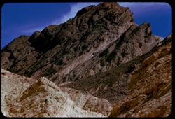
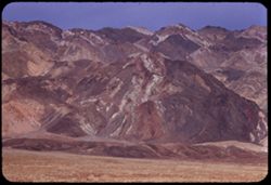
- Description:
- 100 f 8+ tl
- Subject:
- Canyons, Mountains, Rock formations, Clouds, Death Valley National Park (Calif. and Nev.), and Golden Canyon (Inyo County, Calif.)
- Series:
- 9-55
- Creator:
- Cushman, Charles W., 1896-1972
- Date Created:
- 1955-03-22
- Genre:
- Landscape photographs
- Frame Number:
- 15
- County:
- Inyo
- Abstract:
- made inside Golden Canyon
- Call Number:
- P07807
- Country:
- United States
- State/Province:
- California
- Alternate Identifier:
- 955.15
- Persistent URL:
- http://purl.dlib.indiana.edu/iudl/archives/cushman/P07807
- Holding Location:
- Bloomington - University Archives
Wells Library E460
1320 E 10th St.
Bloomington, IN 47405
Contact at archives@indiana.edu, 812-855-1127
-
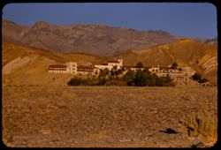
- Description:
- 100 f 5.6
- Subject:
- Valleys, Trees, Mountains, Furnace Creek Inn (Death Valley Junction, Calif.), Hotels, Hills, Funeral Mountains (Calif.), Shrubs, and Death Valley (Calif. and...
- Series:
- 8-55
- Creator:
- Cushman, Charles W., 1896-1972
- Date Created:
- 1955-03-21
- Genre:
- Architectural photographs
- Frame Number:
- 15
- County:
- Inyo
- Abstract:
- Furnace Cr Inn
- Call Number:
- P07773
- City:
- Death Valley Junction
- Country:
- United States
- State/Province:
- California
- Alternate Identifier:
- 855.15
- Persistent URL:
- http://purl.dlib.indiana.edu/iudl/archives/cushman/P07773
- Holding Location:
- Bloomington - University Archives
Wells Library E460
1320 E 10th St.
Bloomington, IN 47405
Contact at archives@indiana.edu, 812-855-1127
-
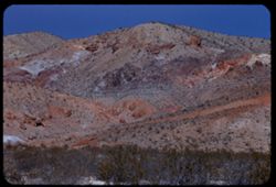
- Description:
- 100 f 8 tl
- Subject:
- Rocks, Electric lines, Wagon Wheel Mountain (Calif.), Mountains, Shrubs, Sierra Nevada (Calif. and Nev.), Hills, Red Hill (Kern County, Calif.), and Jawbone ...
- Series:
- 7-55
- Creator:
- Cushman, Charles W., 1896-1972
- Date Created:
- 1955-03-21
- Genre:
- Landscape photographs
- Frame Number:
- 15
- Street Address:
- United States Highway 6 and Randsburg Road
- County:
- Kern
- Abstract:
- Colorful mtns along US 6 2 mi. south of Wagon Wheel at turn off to Randsburg west of Red Hill
- Call Number:
- P07739
- Country:
- United States
- State/Province:
- California
- Alternate Identifier:
- 755.15
- Persistent URL:
- http://purl.dlib.indiana.edu/iudl/archives/cushman/P07739
- Holding Location:
- Bloomington - University Archives
Wells Library E460
1320 E 10th St.
Bloomington, IN 47405
Contact at archives@indiana.edu, 812-855-1127
-
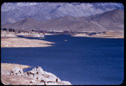
- Description:
- 100 f 5.6
- Subject:
- Rocks, Reservoirs, Roads, Isabella Lake (Calif. : Lake), Mountains, Shrubs, Sierra Nevada (Calif. and Nev.), and Hills
- Series:
- 2-55
- Creator:
- Cushman, Charles W., 1896-1972
- Date Created:
- 1955-02-26
- Genre:
- Landscape photographs
- Frame Number:
- 15
- County:
- Kern
- Abstract:
- NE across Isabella Reservoir at noon
- Call Number:
- P07573
- Country:
- United States
- State/Province:
- California
- Alternate Identifier:
- 255.15
- Persistent URL:
- http://purl.dlib.indiana.edu/iudl/archives/cushman/P07573
- Holding Location:
- Bloomington - University Archives
Wells Library E460
1320 E 10th St.
Bloomington, IN 47405
Contact at archives@indiana.edu, 812-855-1127
-
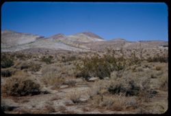
- Description:
- 50 f 11 HF
- Subject:
- Deserts, Striped Mountain (Inyo County, Calif.), Mountains, and Shrubs
- Series:
- 12-54
- Creator:
- Cushman, Charles W., 1896-1972
- Date Created:
- 1954-09-18
- Genre:
- Landscape photographs
- Frame Number:
- 15
- Street Address:
- United States Highway 395 and United States Highway 6
- County:
- Inyo
- Abstract:
- High Sierra wall including Striped Mtn. - 13,160 ft. seen from US 6 - 395 about 10 mi. south of Big Pine.
- Call Number:
- P07405
- City:
- Big Pine
- Country:
- United States
- State/Province:
- California
- Alternate Identifier:
- 1254.15
- Persistent URL:
- http://purl.dlib.indiana.edu/iudl/archives/cushman/P07405
- Holding Location:
- Bloomington - University Archives
Wells Library E460
1320 E 10th St.
Bloomington, IN 47405
Contact at archives@indiana.edu, 812-855-1127
-
- Description:
- 50 f 11
- Subject:
- Canyons, Moon, Mountains, Shrubs, Sierra Nevada (Calif. and Nev.), Trees, Rocks, and Bishop Creek Canyon (Calif.)
- Series:
- 11-54
- Creator:
- Cushman, Charles W., 1896-1972
- Date Created:
- 1954-09-17
- Genre:
- Landscape photographs
- Frame Number:
- 15
- County:
- Inyo
- Abstract:
- View [L] across Bishop Creek canyon with moon above brown mtn.
- Call Number:
- P07384
- Country:
- United States
- State/Province:
- California
- Physical Description:
- Image was originally mounted in a glass enclosure. Before digitization, the image was removed and placed in a Wess Plastic, Inc. brand, 2" x 2", pl...
- Alternate Identifier:
- 1154.15
- Persistent URL:
- http://purl.dlib.indiana.edu/iudl/archives/cushman/P07384
- Holding Location:
- Bloomington - University Archives
Wells Library E460
1320 E 10th St.
Bloomington, IN 47405
Contact at archives@indiana.edu, 812-855-1127
-
- Description:
- 50 f 9
- Subject:
- Rocks, Canyons, Trees, Mountains, and Shrubs
- Series:
- 10-54
- Creator:
- Cushman, Charles W., 1896-1972
- Date Created:
- 1954-09-16
- Genre:
- Landscape photographs
- Frame Number:
- 15
- Street Address:
- Tioga Pass Road
- County:
- Mono
- Abstract:
- Two views east down Tioga Pass Rd.
- Call Number:
- P07362
- Country:
- United States
- State/Province:
- California
- Physical Description:
- Anscochrome film.
- Alternate Identifier:
- 1054.15
- Persistent URL:
- http://purl.dlib.indiana.edu/iudl/archives/cushman/P07362
- Holding Location:
- Bloomington - University Archives
Wells Library E460
1320 E 10th St.
Bloomington, IN 47405
Contact at archives@indiana.edu, 812-855-1127
-
- Description:
- 50 f 9
- Subject:
- Agricultural facilities, Fences, Mountains, Horses, Barns, Grazing, and Sierra Nevada (Calif. and Nev.)
- Series:
- 9-54
- Creator:
- Cushman, Charles W., 1896-1972
- Date Created:
- 1954-09-16
- Genre:
- Landscape photographs
- Frame Number:
- 15
- County:
- Mono
- Abstract:
- View SW from Bridgeport in early am (7:30).
- Call Number:
- P07326
- City:
- Bridgeport
- Country:
- United States
- State/Province:
- California
- Alternate Identifier:
- 954.15
- Persistent URL:
- http://purl.dlib.indiana.edu/iudl/archives/cushman/P07326
- Holding Location:
- Bloomington - University Archives
Wells Library E460
1320 E 10th St.
Bloomington, IN 47405
Contact at archives@indiana.edu, 812-855-1127
-
- Description:
- 25 f 3.5 Pola
- Subject:
- Reservoirs, Roads, Hydroelectric power, Trees, Shasta Dam (Calif.), Mountains, Buildings, Shrubs, Lakes & ponds, Bridges, Power plants, Dams, and Bodies ...
- Series:
- 6-54
- Creator:
- Cushman, Charles W., 1896-1972
- Date Created:
- 1954-08-20
- Genre:
- Views
- Frame Number:
- 15
- County:
- Shasta
- Abstract:
- Shasta dam.
- Call Number:
- P07233
- Country:
- United States
- State/Province:
- California
- Alternate Identifier:
- 654.15
- Persistent URL:
- http://purl.dlib.indiana.edu/iudl/archives/cushman/P07233
- Holding Location:
- Bloomington - University Archives
Wells Library E460
1320 E 10th St.
Bloomington, IN 47405
Contact at archives@indiana.edu, 812-855-1127
-
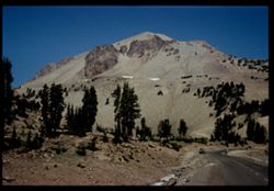
- Description:
- 50 f 9
- Subject:
- Rocks, Roads, Automobiles, Trees, Volcanoes, Volcanic domes, Lassen Volcanic National Park (Calif.), Mountains, Shrubs, Lassen Peak (Calif.), People, Snow, a...
- Series:
- 5-54
- Creator:
- Cushman, Charles W., 1896-1972
- Date Created:
- 1954-08-19
- Genre:
- Landscape photographs
- Frame Number:
- 15
- Street Address:
- National Park Highway
- County:
- Shasta
- Abstract:
- SW flank of Lassen with 2 dark slabs Cushman
- Call Number:
- P07211
- Country:
- United States
- State/Province:
- California
- Physical Description:
- Image was originally mounted in a glass enclosure. Before digitization, the image was removed and placed in a Wess Plastic, Inc. brand, 2" x 2", pl...
- Alternate Identifier:
- 554.15
- Persistent URL:
- http://purl.dlib.indiana.edu/iudl/archives/cushman/P07211
- Holding Location:
- Bloomington - University Archives
Wells Library E460
1320 E 10th St.
Bloomington, IN 47405
Contact at archives@indiana.edu, 812-855-1127
-
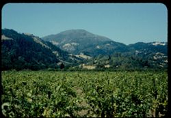
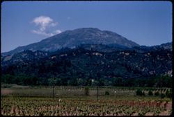
- Description:
- 50 f 9
- Subject:
- Croplands, Saint Helena, Mount (Calif.), Mountains, Shrubs, Trees, Plants, Farms, Grapes, and Napa Valley (Calif.)
- Series:
- 4-54
- Creator:
- Cushman, Charles W., 1896-1972
- Date Created:
- 1954-08-13
- Genre:
- Landscape photographs
- Frame Number:
- 15
- County:
- Napa
- Abstract:
- Mt. St. Helena seen from south across vineyard 2PM
- Call Number:
- P07189
- Country:
- United States
- State/Province:
- California
- Physical Description:
- Anscochrome film.
- Alternate Identifier:
- 454.15
- Persistent URL:
- http://purl.dlib.indiana.edu/iudl/archives/cushman/P07189
- Holding Location:
- Bloomington - University Archives
Wells Library E460
1320 E 10th St.
Bloomington, IN 47405
Contact at archives@indiana.edu, 812-855-1127
-
- Description:
- 50 f 10
- Subject:
- Deserts, Mojave Desert (Calif.), Grasses, Houses, Mountains, Shrubs, and Hills
- Series:
- 16-53
- Creator:
- Cushman, Charles W., 1896-1972
- Date Created:
- 1953-11-23
- Genre:
- Landscape photographs
- Frame Number:
- 15
- Street Address:
- United States Highway 6
- County:
- Kern
- Abstract:
- Desert mountain in color. Near Rosamond
- Call Number:
- P07087
- City:
- Rosamond
- Country:
- United States
- State/Province:
- California
- Alternate Identifier:
- 1653.15
- Persistent URL:
- http://purl.dlib.indiana.edu/iudl/archives/cushman/P07087
- Holding Location:
- Bloomington - University Archives
Wells Library E460
1320 E 10th St.
Bloomington, IN 47405
Contact at archives@indiana.edu, 812-855-1127
-
- Description:
- 50 f 6.3
- Subject:
- Hills, Mountains, Shrubs, Snow, Mingus Mountain (Ariz.), Grasses, and Rocks
- Series:
- 15-53
- Creator:
- Cushman, Charles W., 1896-1972
- Date Created:
- 1953-11-21
- Genre:
- Landscape photographs and Cityscape photographs
- Frame Number:
- 15
- County:
- Yavapai
- Abstract:
- Looking back toward Jerome and Mingus Mtn from Clarkdale
- Call Number:
- P07049
- City:
- Clarkdale and Jerome
- Country:
- United States
- State/Province:
- Arizona
- Physical Description:
- Image was originally mounted in a glass enclosure. Before digitization, the image was removed and placed in a Wess Plastic, Inc. brand, 2" x 2", pl...
- Alternate Identifier:
- 1553.15
- Persistent URL:
- http://purl.dlib.indiana.edu/iudl/archives/cushman/P07049
- Holding Location:
- Bloomington - University Archives
Wells Library E460
1320 E 10th St.
Bloomington, IN 47405
Contact at archives@indiana.edu, 812-855-1127
-
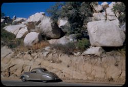
- Description:
- 50 f 11
- Subject:
- Rocks, Grasses, Roads, Automobiles, Boulders, Tree limbs, Mountains, and Rock formations
- Series:
- 14-53
- Creator:
- Cushman, Charles W., 1896-1972
- Date Created:
- 1953-11-19
- Genre:
- Snapshots and Identification photographs
- Frame Number:
- 15
- Street Address:
- United States Highway 60 and United States Highway 70
- County:
- Pinal and Gila
- Abstract:
- Huge boulders above US 70 at summit
- Call Number:
- P07011
- City:
- Superior and Miami
- Country:
- United States
- State/Province:
- Arizona
- Alternate Identifier:
- 1453.15
- Persistent URL:
- http://purl.dlib.indiana.edu/iudl/archives/cushman/P07011
- Holding Location:
- Bloomington - University Archives
Wells Library E460
1320 E 10th St.
Bloomington, IN 47405
Contact at archives@indiana.edu, 812-855-1127
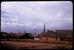
-
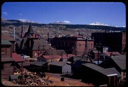
- Description:
- 50 f 11
- Subject:
- Fuelwood, Steeples, Roofs, Churches, Hills, Automobiles, Mountains, Sheds, Buildings, Chimneys, Houses, and Utility poles
- Series:
- 11-53
- Creator:
- Cushman, Charles W., 1896-1972
- Date Created:
- 1953-10-15
- Genre:
- Cityscape photographs
- Frame Number:
- 15
- County:
- Lake
- Abstract:
- Leadville
- Call Number:
- P06894
- City:
- Leadville
- Country:
- United States
- State/Province:
- Colorado
- Alternate Identifier:
- 1153.15
- Persistent URL:
- http://purl.dlib.indiana.edu/iudl/archives/cushman/P06894
- Holding Location:
- Bloomington - University Archives
Wells Library E460
1320 E 10th St.
Bloomington, IN 47405
Contact at archives@indiana.edu, 812-855-1127
-
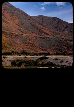
- Description:
- 50 f 5.6 Pola
- Subject:
- Pink brush, Roads, Mountains, Shrubs, Trees, Grasses, and Clouds
- Series:
- 9-53
- Creator:
- Cushman, Charles W., 1896-1972
- Date Created:
- 1953-10-11
- Genre:
- Landscape photographs
- Frame Number:
- 15
- Street Address:
- United States Highway 50
- County:
- Utah
- Abstract:
- From US 50 6 mi w of Thistle.
- Call Number:
- P06816
- City:
- Thistle
- Country:
- United States
- State/Province:
- Utah
- Physical Description:
- masked.
- Alternate Identifier:
- 953.15
- Persistent URL:
- http://purl.dlib.indiana.edu/iudl/archives/cushman/P06816
- Holding Location:
- Bloomington - University Archives
Wells Library E460
1320 E 10th St.
Bloomington, IN 47405
Contact at archives@indiana.edu, 812-855-1127
-
- Description:
- 50 f 7
- Subject:
- Rocks, Trees, Pines, Mountains, Shrubs, and Sierra Nevada (Calif. and Nev.)
- Series:
- 8-53
- Creator:
- Cushman, Charles W., 1896-1972
- Date Created:
- 1953-10-09
- Genre:
- Landscape photographs
- Frame Number:
- 15
- Street Address:
- United States Highway 50
- County:
- El Dorado
- Abstract:
- Back to left from Along US 50 between Kyburz + Phillips. shot high on left bank of Hwy.
- Call Number:
- P06777
- City:
- Kyburz, Phillips, and Little Norway
- Country:
- United States
- State/Province:
- California
- Alternate Identifier:
- 853.15
- Persistent URL:
- http://purl.dlib.indiana.edu/iudl/archives/cushman/P06777
- Holding Location:
- Bloomington - University Archives
Wells Library E460
1320 E 10th St.
Bloomington, IN 47405
Contact at archives@indiana.edu, 812-855-1127
-
- Description:
- 50 f 3.5
- Subject:
- Snow, Yosemite Valley (Calif.), Cliffs, Yosemite National Park (Calif.), Trees, Mountains, National parks & reserves, Clouds, Streams, Mists, and Rocks
- Series:
- 6-53
- Creator:
- Cushman, Charles W., 1896-1972
- Date Created:
- 1953-05-14
- Genre:
- Landscape photographs
- Frame Number:
- 15
- County:
- Mariposa
- Abstract:
- High point above south wall in mist & cloud
- Call Number:
- P06702
- Country:
- United States
- State/Province:
- California
- Alternate Identifier:
- 653.15
- Persistent URL:
- http://purl.dlib.indiana.edu/iudl/archives/cushman/P06702
- Holding Location:
- Bloomington - University Archives
Wells Library E460
1320 E 10th St.
Bloomington, IN 47405
Contact at archives@indiana.edu, 812-855-1127
-

- Description:
- 50 f 6.3 Pola
- Subject:
- Yosemite Falls (Calif.), Yosemite National Park (Calif.), Waterfalls, Trees, Mountains, National parks & reserves, Sentinel Dome (Calif.), and Clouds
- Series:
- 5-53
- Creator:
- Cushman, Charles W., 1896-1972
- Date Created:
- 1953-05-13
- Genre:
- Landscape photographs
- Frame Number:
- 15
- County:
- Mariposa
- Abstract:
- Yosemite Falls from Sentinel Dome.
- Call Number:
- P06665
- Country:
- United States
- State/Province:
- California
- Alternate Identifier:
- 553.15
- Persistent URL:
- http://purl.dlib.indiana.edu/iudl/archives/cushman/P06665
- Holding Location:
- Bloomington - University Archives
Wells Library E460
1320 E 10th St.
Bloomington, IN 47405
Contact at archives@indiana.edu, 812-855-1127
-
- Description:
- 25 f 6.3 Pola
- Subject:
- Twin Peaks (San Francisco County, Calif.), Kezar Stadium (San Francisco, Calif.), Roofs, Streets, Bodies of water, Stadiums, Bridges, Mountains, Tamalpais, M...
- Series:
- 4-53
- Creator:
- Cushman, Charles W., 1896-1972
- Date Created:
- 1953-04-10
- Genre:
- Cityscape photographs
- Frame Number:
- 15
- Street Address:
- Clavenden Avenue and Twin Peaks Boulevard
- County:
- San Francisco
- Abstract:
- From Clavenden + Twin Pks. Ave. - view NNW across Kezar Stadium + GG Park toward Tamalpais.
- Call Number:
- P06626
- City:
- San Francisco
- Country:
- United States
- State/Province:
- California
- Alternate Identifier:
- 453.15
- Persistent URL:
- http://purl.dlib.indiana.edu/iudl/archives/cushman/P06626
- Holding Location:
- Bloomington - University Archives
Wells Library E460
1320 E 10th St.
Bloomington, IN 47405
Contact at archives@indiana.edu, 812-855-1127
-

- Description:
- 25 f 6.3 Pola
- Subject:
- Deserts, Mining, Mountains, Shrubs, Hills, and Mining equipment
- Series:
- 28-52
- Creator:
- Cushman, Charles W., 1896-1972
- Date Created:
- 1952-11-08
- Genre:
- Landscape photographs
- Frame Number:
- 15
- County:
- Storey
- Abstract:
- Panorama east from Va. City.
- Call Number:
- P06499
- City:
- Virginia City
- Country:
- United States
- State/Province:
- Nevada
- Alternate Identifier:
- 2852.15
- Persistent URL:
- http://purl.dlib.indiana.edu/iudl/archives/cushman/P06499
- Holding Location:
- Bloomington - University Archives
Wells Library E460
1320 E 10th St.
Bloomington, IN 47405
Contact at archives@indiana.edu, 812-855-1127
-
- Description:
- 25 f 5.6 Pola
- Subject:
- Rocky Mountains, Crosses, Grasses, Houses, Mountains, Churches, Clotheslines, Clouds, Railroad tracks, Elbert, Mount (Colo.), Buildings, Massive, Mount (Colo...
- Series:
- 25-52
- Creator:
- Cushman, Charles W., 1896-1972
- Date Created:
- 1952-11-02
- Genre:
- Views
- Frame Number:
- 15
- County:
- Lake
- Abstract:
- Mt Elbert from Leadville.
- Call Number:
- P06384
- City:
- Leadville
- Country:
- United States
- State/Province:
- Colorado
- Alternate Identifier:
- 2552.15
- Persistent URL:
- http://purl.dlib.indiana.edu/iudl/archives/cushman/P06384
- Holding Location:
- Bloomington - University Archives
Wells Library E460
1320 E 10th St.
Bloomington, IN 47405
Contact at archives@indiana.edu, 812-855-1127
-
- Description:
- 25 f 11
- Subject:
- Croplands, Red Rocks Park (Jefferson County, Colo.), Rocky Mountains, Houses, Outbuildings, Mountains, Trees, Rock formations, Fences, Red Rocks Amphitheatre...
- Series:
- 24-52
- Creator:
- Cushman, Charles W., 1896-1972
- Date Created:
- 1952-10-31
- Genre:
- Landscape photographs
- Frame Number:
- 15
- Street Address:
- Colorado State Highway 74
- County:
- Jefferson
- Abstract:
- Along Colo 74 - mtn side near Red Rocks theatre.
- Call Number:
- P06346
- City:
- Morrison
- Country:
- United States
- State/Province:
- Colorado
- Physical Description:
- Image was originally mounted in a glass enclosure. Before digitization, the image was removed and placed in a Wess Plastic, Inc. brand, 2" x 2", pl...
- Alternate Identifier:
- 2452.15
- Persistent URL:
- http://purl.dlib.indiana.edu/iudl/archives/cushman/P06346
- Holding Location:
- Bloomington - University Archives
Wells Library E460
1320 E 10th St.
Bloomington, IN 47405
Contact at archives@indiana.edu, 812-855-1127
-
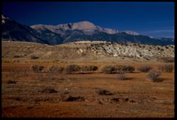
- Description:
- 25 f 7 Pola
- Subject:
- Grasses, Trees, Mountains, Shrubs, White House Ranch (Colorado Springs, Colo.), Pikes Peak (Colo.), and Hills
- Series:
- 21-52
- Creator:
- Cushman, Charles W., 1896-1972
- Date Created:
- 1952-10-27
- Genre:
- Landscape photographs
- Frame Number:
- 15
- County:
- El Paso
- Persons Pictured:
- Cushman, Charles W. (Charles Weever), 1896-1972
- Abstract:
- The majesty of Pike's Peak-view from White House ranch
- Call Number:
- P06246
- City:
- Colorado Springs
- Country:
- United States
- State/Province:
- Colorado
- Physical Description:
- Image was originally mounted in a glass enclosure. Before digitization, the image was removed and placed in a Wess Plastic, Inc. brand, 2" x 2", pl...
- Alternate Identifier:
- 2152.15
- Persistent URL:
- http://purl.dlib.indiana.edu/iudl/archives/cushman/P06246
- Holding Location:
- Bloomington - University Archives
Wells Library E460
1320 E 10th St.
Bloomington, IN 47405
Contact at archives@indiana.edu, 812-855-1127
-
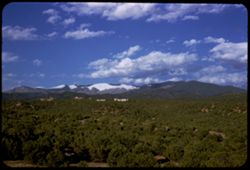
- Description:
- 25 f 13
- Subject:
- Snow, Santa Fe Baldy (N.M.), Trees, Mountains, Buildings, Aspen Peak (Santa Fe County, N.M.), Clouds, Forests, Hills, Junipers, and Sangre de Cristo Mountain...
- Series:
- 18-52
- Creator:
- Cushman, Charles W., 1896-1972
- Date Created:
- 1952-04-14
- Genre:
- Landscape photographs
- Frame Number:
- 15
- County:
- Santa Fe
- Abstract:
- Across the Juniper forest to Santa Fe. Baldy (12661) with heavy snow cap of Aspen Pk. prominent.
- Call Number:
- P06146
- City:
- Santa Fe
- Country:
- United States
- State/Province:
- New Mexico
- Alternate Identifier:
- 1852.15
- Persistent URL:
- http://purl.dlib.indiana.edu/iudl/archives/cushman/P06146
- Holding Location:
- Bloomington - University Archives
Wells Library E460
1320 E 10th St.
Bloomington, IN 47405
Contact at archives@indiana.edu, 812-855-1127
-
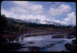
- Description:
- 25 f 13
- Subject:
- Snow, Puddles, San Francisco Peaks (Ariz.), Trees, Mountains, Clouds, Hills, Rocks, Mud, Electric lines, and Bodies of water
- Series:
- 16-52
- Creator:
- Cushman, Charles W., 1896-1972
- Date Created:
- 1952-04-11
- Genre:
- Landscape photographs
- Frame Number:
- 15
- Street Address:
- United States Highway 66
- County:
- Coconino
- Abstract:
- San Francisco Pks-from 5 mi west of Flagstaff on 66
- Call Number:
- P06073
- City:
- Flagstaff
- Country:
- United States
- State/Province:
- Arizona
- Alternate Identifier:
- 1652.15
- Persistent URL:
- http://purl.dlib.indiana.edu/iudl/archives/cushman/P06073
- Holding Location:
- Bloomington - University Archives
Wells Library E460
1320 E 10th St.
Bloomington, IN 47405
Contact at archives@indiana.edu, 812-855-1127
-

- Description:
- 50 f 9
- Subject:
- Snow, Houses, Farms, Trees, Croplands, Fences, Whitney, Mount (Calif.), Sierra Nevada (Calif. and Nev.), Hills, Agricultural facilities, Mountains, Williamso...
- Series:
- 14-52
- Creator:
- Cushman, Charles W., 1896-1972
- Date Created:
- 1952-04-08
- Genre:
- Landscape photographs
- Frame Number:
- 15
- County:
- Inyo
- Abstract:
- Mt. Whitney et al. Behind cloud.
- Call Number:
- P05999
- City:
- Lone Pine
- Country:
- United States
- State/Province:
- California
- Alternate Identifier:
- 1452.15
- Persistent URL:
- http://purl.dlib.indiana.edu/iudl/archives/cushman/P05999
- Holding Location:
- Bloomington - University Archives
Wells Library E460
1320 E 10th St.
Bloomington, IN 47405
Contact at archives@indiana.edu, 812-855-1127
-
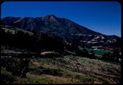
- Description:
- 25 f 6.3 Pola
- Subject:
- Wildflowers, Grasses, Roads, Trees, Mountains, Shrubs, Tamalpais, Mount (Calif.), Utility poles, and Houses
- Series:
- 12-52
- Creator:
- Cushman, Charles W., 1896-1972
- Date Created:
- 1952-03-30
- Genre:
- Landscape photographs
- Frame Number:
- 15
- County:
- Marin
- Abstract:
- Mt. Tamalpais from road above Mill Valley.
- Call Number:
- P05922
- City:
- Mill Valley
- Country:
- United States
- State/Province:
- California
- Alternate Identifier:
- 1252.15
- Persistent URL:
- http://purl.dlib.indiana.edu/iudl/archives/cushman/P05922
- Holding Location:
- Bloomington - University Archives
Wells Library E460
1320 E 10th St.
Bloomington, IN 47405
Contact at archives@indiana.edu, 812-855-1127
-
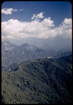
- Description:
- 25 f 5.6 pola
- Subject:
- Mount Wilson (Calif.), Mountains, Pines, Clouds, and San Gabriel Mountains (Calif.)
- Series:
- 6-52
- Creator:
- Cushman, Charles W., 1896-1972
- Date Created:
- 1952-02-18
- Genre:
- Landscape photographs
- Frame Number:
- 15
- County:
- Los Angeles
- Abstract:
- NE from Mt. Wilson
- Call Number:
- P05698
- Country:
- United States
- State/Province:
- California
- Alternate Identifier:
- 652.15
- Persistent URL:
- http://purl.dlib.indiana.edu/iudl/archives/cushman/P05698
- Holding Location:
- Bloomington - University Archives
Wells Library E460
1320 E 10th St.
Bloomington, IN 47405
Contact at archives@indiana.edu, 812-855-1127
-
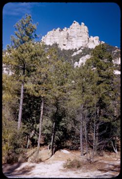
- Description:
- 5 f 9
- Subject:
- Bear Canyon (Pima County, Ariz.), Trees, Mountains, Shrubs, and Rock formations
- Series:
- 4-52
- Creator:
- Cushman, Charles W., 1896-1972
- Date Created:
- 1952-01-25
- Genre:
- Landscape photographs
- Frame Number:
- 15
- Street Address:
- Mount Lemmon Road
- Abstract:
- Rocky comb from Mt. Lemmon Rd. at Bear Canyon Picnic area 5 f 9 ?25 in error
- Call Number:
- P05621
- Country:
- United States
- State/Province:
- Arizona
- Alternate Identifier:
- 452.15
- Persistent URL:
- http://purl.dlib.indiana.edu/iudl/archives/cushman/P05621
- Holding Location:
- Bloomington - University Archives
Wells Library E460
1320 E 10th St.
Bloomington, IN 47405
Contact at archives@indiana.edu, 812-855-1127
-
- Description:
- 50 f 8
- Subject:
- Children, Cotton, Farms, Croplands, Boys, Cotton industry, and Mountains
- Series:
- 2-52
- Creator:
- Cushman, Charles W., 1896-1972
- Date Created:
- 1952-01-11
- Genre:
- Portraits
- Frame Number:
- 15
- Street Address:
- Nogales Highway
- County:
- Pima
- Abstract:
- Scene of cotton picking along Nogales Hwy 12 mi. south of Tucson.
- Call Number:
- P05545
- City:
- Tucson
- Country:
- United States
- State/Province:
- Arizona
- Alternate Identifier:
- 252.15
- Persistent URL:
- http://purl.dlib.indiana.edu/iudl/archives/cushman/P05545
- Holding Location:
- Bloomington - University Archives
Wells Library E460
1320 E 10th St.
Bloomington, IN 47405
Contact at archives@indiana.edu, 812-855-1127
-
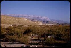
- Description:
- 25 f 11
- Subject:
- Reserva de la Biosfera Santa Elena-Sierra del Carmen (Mexico), Rio Grande, Horses, Boquillas Canyon (Big Bend National Park (Tex.)), Corrals, Mountains, Fenc...
- Series:
- 16-51
- Creator:
- Cushman, Charles W., 1896-1972
- Date Created:
- 1951-12-27
- Genre:
- Landscape photographs
- Frame Number:
- 15
- County:
- Brewster
- Abstract:
- View across Boquillas to Mex. Side of R. Grande.
- Call Number:
- P05434
- Country:
- United States and Mexico
- State/Province:
- Texas
- Alternate Identifier:
- 1651.15
- Persistent URL:
- http://purl.dlib.indiana.edu/iudl/archives/cushman/P05434
- Holding Location:
- Bloomington - University Archives
Wells Library E460
1320 E 10th St.
Bloomington, IN 47405
Contact at archives@indiana.edu, 812-855-1127
-
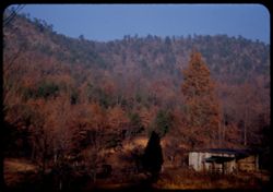
- Description:
- 25 f 7
- Subject:
- Mountains and Trees
- Series:
- 8-51
- Creator:
- Cushman, Charles W., 1896-1972
- Date Created:
- 1951-12-02
- Genre:
- Landscape photographs
- Frame Number:
- 15
- Street Address:
- United States Highway 41
- County:
- Hamilton
- Abstract:
- Mtn ridge from Hwy 41 west of Chattenooga
- Call Number:
- P05120
- City:
- Chattanooga
- Country:
- United States
- State/Province:
- Tennessee
- Alternate Identifier:
- 851.15
- Persistent URL:
- http://purl.dlib.indiana.edu/iudl/archives/cushman/P05120
- Holding Location:
- Bloomington - University Archives
Wells Library E460
1320 E 10th St.
Bloomington, IN 47405
Contact at archives@indiana.edu, 812-855-1127
-
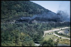
- Subject:
- Railroad freight cars, Pennsylvania Railroad, Horseshoe Curve National Historic Landmark (Pa.), Mountains, Forests, Allegheny Mountains, Railroads, Trees, an...
- Series:
- 21-41
- Creator:
- Cushman, Charles W., 1896-1972
- Date Created:
- 1941-09-30
- Genre:
- Snapshots and Views
- Frame Number:
- 15
- County:
- Blair
- Abstract:
- PRR passenger train doubleheader at Horseshoe Curve.
- Call Number:
- P02537
- City:
- Altoona
- Country:
- United States
- State/Province:
- Pennsylvania
- Physical Description:
- Image was originally mounted in a glass enclosure. Before digitization, the image was removed and placed in a Wess Plastic, Inc. brand, 2" x 2", pl...
- Alternate Identifier:
- 2141.15
- Persistent URL:
- http://purl.dlib.indiana.edu/iudl/archives/cushman/P02537
- Holding Location:
- Bloomington - University Archives
Wells Library E460
1320 E 10th St.
Bloomington, IN 47405
Contact at archives@indiana.edu, 812-855-1127
-
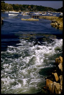
- Subject:
- Rocks, Piers & wharves, Seas, Trees, Scituate Harbor (Mass.), Mountains, Harbors, Dwellings, and Boats
- Series:
- 19-41
- Creator:
- Cushman, Charles W., 1896-1972
- Date Created:
- 1941-09-22
- Genre:
- Marine photographs
- Frame Number:
- 15
- County:
- Plymouth
- Abstract:
- Inrushing tide near Scituate Harbor, Mass.
- Call Number:
- P02496
- City:
- Scituate
- Country:
- United States
- State/Province:
- Massachusetts
- Physical Description:
- Image was originally mounted in a glass enclosure. Before digitization, the image was removed and placed in a Wess Plastic, Inc. brand, 2" x 2", pl...
- Alternate Identifier:
- 1941.15
- Persistent URL:
- http://purl.dlib.indiana.edu/iudl/archives/cushman/P02496
- Holding Location:
- Bloomington - University Archives
Wells Library E460
1320 E 10th St.
Bloomington, IN 47405
Contact at archives@indiana.edu, 812-855-1127
-
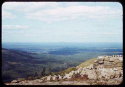
- Subject:
- Acadia National Park (Me.), Boulders, Mountains, and Cadillac Mountain (Me.)
- Series:
- 17-41
- Creator:
- Cushman, Charles W., 1896-1972
- Date Created:
- 1941-09-18
- Genre:
- Landscape photographs
- Frame Number:
- 15
- County:
- Hancock
- Abstract:
- View northward from top of Mt Desert Island.
- Call Number:
- P02457
- City:
- Mount Desert Island
- Country:
- United States
- State/Province:
- Maine
- Alternate Identifier:
- 1741.15
- Persistent URL:
- http://purl.dlib.indiana.edu/iudl/archives/cushman/P02457
- Holding Location:
- Bloomington - University Archives
Wells Library E460
1320 E 10th St.
Bloomington, IN 47405
Contact at archives@indiana.edu, 812-855-1127
-
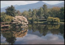
- Subject:
- Franconia Hotel (Franconia, N.H.), Trees, Flowers, Mountains, Fences, Shrubs, Lakes & ponds, Bridges, and Reflections
- Series:
- 16-41
- Creator:
- Cushman, Charles W., 1896-1972
- Date Created:
- 1941-09-15
- Genre:
- Landscape photographs
- Frame Number:
- 15
- County:
- Grafton
- Abstract:
- Reflection of White Mtns. in pool at Franconia Hotel
- Call Number:
- P02436
- City:
- Franconia
- Country:
- United States
- State/Province:
- New Hampshire
- Physical Description:
- Image was originally mounted in a glass enclosure. Before digitization, the image was removed and placed in a Wess Plastic, Inc. brand, 2" x 2", pl...
- Alternate Identifier:
- 1641.15
- Persistent URL:
- http://purl.dlib.indiana.edu/iudl/archives/cushman/P02436
- Holding Location:
- Bloomington - University Archives
Wells Library E460
1320 E 10th St.
Bloomington, IN 47405
Contact at archives@indiana.edu, 812-855-1127
-
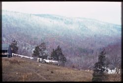
- Subject:
- Trails & paths, Trees, Mountains, Shrubs, Dwellings, Allegheny Mountains, and Clotheslines
- Series:
- 20-40
- Creator:
- Cushman, Charles W., 1896-1972
- Date Created:
- 1940-11-15
- Genre:
- Landscape photographs
- Frame Number:
- 15
- County:
- Covington
- Abstract:
- November snow whitens Alleghenies west of Corington, Va.
- Call Number:
- P02141
- City:
- Covington
- Country:
- United States
- State/Province:
- Virginia
- Physical Description:
- Image was originally mounted in a glass enclosure. Before digitization, the image was removed and placed in a Wess Plastic, Inc. brand, 2" x 2", pl...
- Alternate Identifier:
- 2040.15
- Persistent URL:
- http://purl.dlib.indiana.edu/iudl/archives/cushman/P02141
- Holding Location:
- Bloomington - University Archives
Wells Library E460
1320 E 10th St.
Bloomington, IN 47405
Contact at archives@indiana.edu, 812-855-1127
-
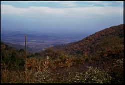
- Subject:
- Wildflowers, Trees, Blue Ridge Mountains, Mountains, Shrubs, Clouds, and Facilities
- Series:
- 18-40
- Creator:
- Cushman, Charles W., 1896-1972
- Date Created:
- 1940-10-11
- Genre:
- Landscape photographs
- Frame Number:
- 15
- Street Address:
- Skyline Drive
- Abstract:
- Eastward from Skyline Drive toward Piedmont.
- Call Number:
- P02101
- City:
- Piedmont
- Country:
- United States
- State/Province:
- Virginia
- Physical Description:
- Image was originally mounted in a glass enclosure. Before digitization, the image was removed and placed in a Wess Plastic, Inc. brand, 2" x 2", pl...
- Alternate Identifier:
- 1840.15
- Persistent URL:
- http://purl.dlib.indiana.edu/iudl/archives/cushman/P02101
- Holding Location:
- Bloomington - University Archives
Wells Library E460
1320 E 10th St.
Bloomington, IN 47405
Contact at archives@indiana.edu, 812-855-1127
-
From heights above Hapers Ferry junction of 3 states, where the Shenandoah meets the Potomac Cushman
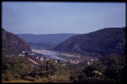
- Subject:
- Trees, Flowers, Shenandoah River (Va. and W. Va.), Potomac River, Mountains, Tunnels, Bridges, Rivers, and Railroad bridges
- Series:
- 16-40
- Creator:
- Cushman, Charles W., 1896-1972
- Date Created:
- 1940-09-16/1940-09-23
- Genre:
- Landscape photographs
- Frame Number:
- 15
- County:
- Jefferson
- Abstract:
- From heights above Harpers Ferry, the junction of 3 states, where Shen. meets Potomac.
- Call Number:
- P02064
- City:
- Harpers Ferry
- Country:
- United States
- State/Province:
- West Virginia
- Physical Description:
- Image was originally mounted in a glass enclosure. Before digitization, the image was removed and placed in a Wess Plastic, Inc. brand, 2" x 2", pl...
- Alternate Identifier:
- 1640.15
- Persistent URL:
- http://purl.dlib.indiana.edu/iudl/archives/cushman/P02064
- Holding Location:
- Bloomington - University Archives
Wells Library E460
1320 E 10th St.
Bloomington, IN 47405
Contact at archives@indiana.edu, 812-855-1127
-
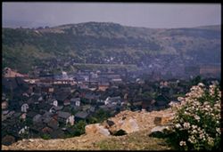
- Subject:
- Roofs, Roads, Mountains, Dwellings, Trees, Buildings, Utility poles, and Shrubs
- Series:
- 14-40
- Creator:
- Cushman, Charles W., 1896-1972
- Date Created:
- 1940-07-18/1940-07-26
- Genre:
- Cityscape photographs
- Frame Number:
- 15
- County:
- Cambria
- Abstract:
- Across the roofs of Johnstown, Penna
- Call Number:
- P02033
- City:
- Johnstown
- Country:
- United States
- State/Province:
- Pennsylvania
- Physical Description:
- Image was originally mounted in a glass enclosure. Before digitization, the image was removed and placed in a Wess Plastic, Inc. brand, 2" x 2", pl...
- Alternate Identifier:
- 1440.15
- Persistent URL:
- http://purl.dlib.indiana.edu/iudl/archives/cushman/P02033
- Holding Location:
- Bloomington - University Archives
Wells Library E460
1320 E 10th St.
Bloomington, IN 47405
Contact at archives@indiana.edu, 812-855-1127
-
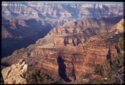
- Subject:
- Bright Angel Point (Ariz.), Canyons, Cliffs, Trees, Shadows, Mountains, National parks & reserves, and Grand Canyon (Ariz.)
- Series:
- 12-40
- Creator:
- Cushman, Charles W., 1896-1972
- Date Created:
- 1940-07-13
- Genre:
- Landscape photographs
- Frame Number:
- 15
- County:
- Coconino
- Abstract:
- View south from B.A. Pt. In morning. B.A. canyon at left.
- Call Number:
- P01994
- Country:
- United States
- State/Province:
- Arizona
- Physical Description:
- Image was originally mounted in a glass enclosure. Before digitization, the image was removed and placed in a Wess Plastic, Inc. brand, 2" x 2", pl...
- Alternate Identifier:
- 1240.15
- Persistent URL:
- http://purl.dlib.indiana.edu/iudl/archives/cushman/P01994
- Holding Location:
- Bloomington - University Archives
Wells Library E460
1320 E 10th St.
Bloomington, IN 47405
Contact at archives@indiana.edu, 812-855-1127
-
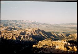
- Subject:
- Canyons, Bryce Canyon National Park (Utah), Trees, Shadows, Mountains, Shrubs, Bryce Canyon (Utah : Valley), Sunrises & sunsets, and National parks &...
- Series:
- 11-40
- Creator:
- Cushman, Charles W., 1896-1972
- Date Created:
- 1940-07-11
- Genre:
- Landscape photographs
- Frame Number:
- 15
- County:
- Garfield
- Abstract:
- Bryce Canyon at sunset, from west rim.
- Call Number:
- P01975
- Country:
- United States
- State/Province:
- Utah
- Physical Description:
- Image was originally mounted in a glass enclosure. Before digitization, the image was removed and placed in a Wess Plastic, Inc. brand, 2" x 2", pl...
- Alternate Identifier:
- 1140.15
- Persistent URL:
- http://purl.dlib.indiana.edu/iudl/archives/cushman/P01975
- Holding Location:
- Bloomington - University Archives
Wells Library E460
1320 E 10th St.
Bloomington, IN 47405
Contact at archives@indiana.edu, 812-855-1127