
Search Constraints
You searched for:
Campus
IUB
Remove constraint Campus: IUB
Frame Number
17
Remove constraint Frame Number: 17
Subject
Mountains
Remove constraint Subject: Mountains
1 - 89 of 89
Search Results
-
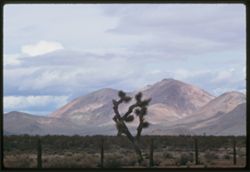
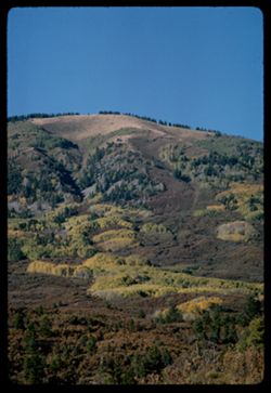
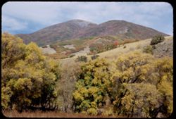
- Description:
- 100 f 9 TL
- Subject:
- Deserts, Mojave Desert (Calif.), Tehachapi Mountains (Calif.), Cactus, Mountains, Fences, Shrubs, and Clouds
- Series:
- 3-69
- Creator:
- Cushman, Charles W., 1896-1972
- Date Created:
- 1969-03-21
- Genre:
- Landscape photographs
- Frame Number:
- 17
- Street Address:
- California State Highway 14
- County:
- Kern
- Abstract:
- Toward Tehachapi Mtns from Hwy 14
- Call Number:
- P15769
- City:
- Mojave
- Country:
- United States
- State/Province:
- California
- Alternate Identifier:
- 369.17
- Persistent URL:
- http://purl.dlib.indiana.edu/iudl/archives/cushman/P15769
- Holding Location:
- Bloomington - University Archives
Wells Library E460
1320 E 10th St.
Bloomington, IN 47405
Contact at archives@indiana.edu, 812-855-1127
-
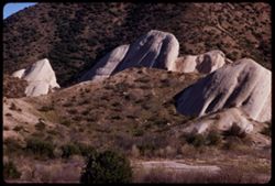
- Description:
- 100 f 9 TL
- Subject:
- Passes (Landforms), Hills, Cajon Pass (Calif.), Shrubs, Trees, Rock formations, Mountains, and Grasses
- Series:
- 2-69
- Creator:
- Cushman, Charles W., 1896-1972
- Date Created:
- 1969-03-14
- Genre:
- Landscape photographs
- Frame Number:
- 17
- County:
- San Bernardino
- Abstract:
- Cajon Pass
- Call Number:
- P15734
- Country:
- United States
- State/Province:
- California
- Alternate Identifier:
- 269.17
- Persistent URL:
- http://purl.dlib.indiana.edu/iudl/archives/cushman/P15734
- Holding Location:
- Bloomington - University Archives
Wells Library E460
1320 E 10th St.
Bloomington, IN 47405
Contact at archives@indiana.edu, 812-855-1127
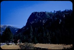
-
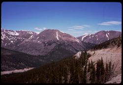
- Subject:
- Snow, Roads, Trees, Mountains, Clouds, Forests, Passes (Landforms), and Loveland Pass (Colo.)
- Series:
- 9-66
- Creator:
- Cushman, Charles W., 1896-1972
- Date Created:
- 1966-06-14
- Genre:
- Landscape photographs
- Frame Number:
- 17
- County:
- Larimer
- Call Number:
- P15420
- Country:
- United States
- State/Province:
- Colorado
- Alternate Identifier:
- 966.17
- Persistent URL:
- http://purl.dlib.indiana.edu/iudl/archives/cushman/P15420
- Holding Location:
- Bloomington - University Archives
Wells Library E460
1320 E 10th St.
Bloomington, IN 47405
Contact at archives@indiana.edu, 812-855-1127
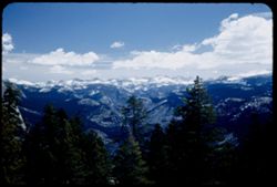
-
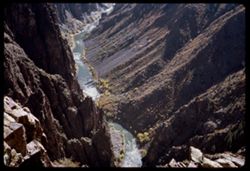
- Description:
- 100 f 9
- Subject:
- Black Canyon of the Gunnison National Park (Colo.), Pulpit Rock (Colo.), Canyons, Cliffs, Mountains, Black Canyon of the Gunnison (Colo.), Rivers, National p...
- Series:
- 35-65
- Creator:
- Cushman, Charles W., 1896-1972
- Date Created:
- 1965-10-05
- Genre:
- Landscape photographs
- Frame Number:
- 17
- County:
- Montrose
- Abstract:
- From Pulpit Rock Overlook.
- Call Number:
- P15047
- Country:
- United States
- State/Province:
- Colorado
- Alternate Identifier:
- 3565.17
- Persistent URL:
- http://purl.dlib.indiana.edu/iudl/archives/cushman/P15047
- Holding Location:
- Bloomington - University Archives
Wells Library E460
1320 E 10th St.
Bloomington, IN 47405
Contact at archives@indiana.edu, 812-855-1127
-
- Description:
- 200 f 9 tl
- Subject:
- San Juan National Forest (Colo.), Trees, Mountains, and Forests
- Series:
- 34-65
- Creator:
- Cushman, Charles W., 1896-1972
- Date Created:
- 1965-10-03
- Genre:
- Landscape photographs
- Frame Number:
- 17
- Street Address:
- United States Highway 160
- County:
- La Plata and Montezuma
- Abstract:
- Mtn side seen from Hwy 160 on leaving San Juan Nat'l Forest
- Call Number:
- P15009
- City:
- Mancos and Durango
- Country:
- United States
- State/Province:
- Colorado
- Alternate Identifier:
- 3465.17
- Persistent URL:
- http://purl.dlib.indiana.edu/iudl/archives/cushman/P15009
- Holding Location:
- Bloomington - University Archives
Wells Library E460
1320 E 10th St.
Bloomington, IN 47405
Contact at archives@indiana.edu, 812-855-1127
-
- Description:
- 100 f 16 sl
- Subject:
- Snow, Kendall Mountain (Colo.), Trees, Mountains, Fences, Roads, Buildings, and Sidewalks
- Series:
- 33-65
- Creator:
- Cushman, Charles W., 1896-1972
- Date Created:
- 1965-10-02
- Genre:
- Landscape photographs
- Frame Number:
- 17
- County:
- San Juan
- Abstract:
- Mtn. above town
- Call Number:
- P14972
- City:
- Silverton
- Country:
- United States
- State/Province:
- Colorado
- Alternate Identifier:
- 3365.17
- Persistent URL:
- http://purl.dlib.indiana.edu/iudl/archives/cushman/P14972
- Holding Location:
- Bloomington - University Archives
Wells Library E460
1320 E 10th St.
Bloomington, IN 47405
Contact at archives@indiana.edu, 812-855-1127
-
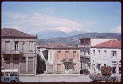
- Description:
- 100 f 11
- Subject:
- Snow, Balconies, Mountains, Dwellings, Hills, Parnassus, Mount (Greece), and Doors & doorways
- Series:
- 11-65
- Creator:
- Cushman, Charles W., 1896-1972
- Date Created:
- 1965-04-21
- Genre:
- Landscape photographs and Cityscape photographs
- Frame Number:
- 17
- County:
- Boeotia
- Abstract:
- Levadhia
- Call Number:
- P14218
- City:
- Levadhia
- Country:
- Greece
- State/Province:
- Central Greece and Euboea
- Alternate Identifier:
- 1165.17
- Persistent URL:
- http://purl.dlib.indiana.edu/iudl/archives/cushman/P14218
- Holding Location:
- Bloomington - University Archives
Wells Library E460
1320 E 10th St.
Bloomington, IN 47405
Contact at archives@indiana.edu, 812-855-1127
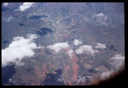
-
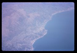
- Subject:
- Seas, Coastlines, British European Airways Corporation, Mountains, Air travel, and Ligurian Sea
- Series:
- 3-65
- Creator:
- Cushman, Charles W., 1896-1972
- Date Created:
- 1965-04-01
- Genre:
- Aerial photographs and Landscape photographs
- Frame Number:
- 17
- Abstract:
- Ligurian coast.
- Call Number:
- P13923
- Country:
- Italy
- State/Province:
- Liguria
- Alternate Identifier:
- 365.17
- Persistent URL:
- http://purl.dlib.indiana.edu/iudl/archives/cushman/P13923
- Holding Location:
- Bloomington - University Archives
Wells Library E460
1320 E 10th St.
Bloomington, IN 47405
Contact at archives@indiana.edu, 812-855-1127
-
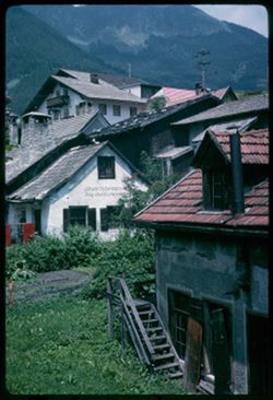
- Description:
- 100 f 11
- Subject:
- Valleys, Roofs, Stairways, Mountains, Buildings, Shrubs, Stubay Valley (Austria), Dormers, Dwellings, Utility poles, and Doors & doorways
- Series:
- 17-64
- Creator:
- Cushman, Charles W., 1896-1972
- Date Created:
- 1964-06-09
- Genre:
- Cityscape photographs
- Frame Number:
- 17
- Abstract:
- Fulpmes- view up
- Call Number:
- P13558
- City:
- Fulpmes
- Country:
- Austria
- State/Province:
- Tyrol
- Alternate Identifier:
- 1764.17
- Persistent URL:
- http://purl.dlib.indiana.edu/iudl/archives/cushman/P13558
- Holding Location:
- Bloomington - University Archives
Wells Library E460
1320 E 10th St.
Bloomington, IN 47405
Contact at archives@indiana.edu, 812-855-1127
-

- Description:
- 100 f 11
- Subject:
- Snow, Valleys, Inn River, Inn River Valley, Cities & towns, Forests, Alps, Austrian (Austria), Rivers, Mountains, and Croplands
- Series:
- 15-64
- Creator:
- Cushman, Charles W., 1896-1972
- Date Created:
- 1964-06-04
- Genre:
- Landscape photographs and Cityscape photographs
- Frame Number:
- 17
- Abstract:
- Views from cable car down
- Call Number:
- P13482
- City:
- Innsbruck
- Country:
- Austria
- State/Province:
- Tyrol
- Alternate Identifier:
- 1564.17
- Persistent URL:
- http://purl.dlib.indiana.edu/iudl/archives/cushman/P13482
- Holding Location:
- Bloomington - University Archives
Wells Library E460
1320 E 10th St.
Bloomington, IN 47405
Contact at archives@indiana.edu, 812-855-1127
-
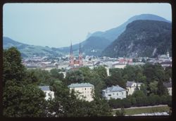
- Description:
- 100 f 11
- Subject:
- Bell towers, Salzach River (Austria and Germany), Trees, Mountains, Churches, Waterfronts, Dwellings, Spires, Monchsberg (Salzburg, Austria), and Buildings
- Series:
- 12-64
- Creator:
- Cushman, Charles W., 1896-1972
- Date Created:
- 1964-05-30
- Genre:
- Landscape photographs and Cityscape photographs
- Frame Number:
- 17
- Abstract:
- Twin spires & far peak
- Call Number:
- P13370
- City:
- Salzburg
- Country:
- Austria
- State/Province:
- Salzburg
- Alternate Identifier:
- 1264.17
- Persistent URL:
- http://purl.dlib.indiana.edu/iudl/archives/cushman/P13370
- Holding Location:
- Bloomington - University Archives
Wells Library E460
1320 E 10th St.
Bloomington, IN 47405
Contact at archives@indiana.edu, 812-855-1127
-
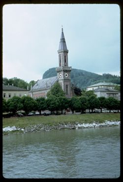
- Description:
- 100 f 5.6
- Subject:
- Clock towers, Churches, Internationale Stiftung Mozarteum Salzburg, Automobiles, Mountains, Dwellings, Trees, Rocks, Architectural decorations & ornament...
- Series:
- 11-64
- Creator:
- Cushman, Charles W., 1896-1972
- Date Created:
- 1964-05-29
- Genre:
- Cityscape photographs and Architectural photographs
- Frame Number:
- 17
- Abstract:
- Evangelische Church near Mozarteum
- Call Number:
- P13332
- City:
- Salzburg
- Country:
- Austria
- State/Province:
- Salzburg
- Alternate Identifier:
- 1164.17
- Persistent URL:
- http://purl.dlib.indiana.edu/iudl/archives/cushman/P13332
- Holding Location:
- Bloomington - University Archives
Wells Library E460
1320 E 10th St.
Bloomington, IN 47405
Contact at archives@indiana.edu, 812-855-1127
-
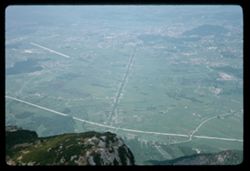
- Description:
- 100 f 8
- Subject:
- Rock formations, Hills, Mountains, Untersberg (Austria), Shrubs, Roads, Airports, and Cliffs
- Series:
- 9-64
- Creator:
- Cushman, Charles W., 1896-1972
- Date Created:
- 1964-05-24
- Genre:
- Landscape photographs
- Frame Number:
- 17
- Abstract:
- On Untersberg Toward Salzburg
- Call Number:
- P13257
- City:
- Salzburg
- Country:
- Austria
- State/Province:
- Salzburg
- Alternate Identifier:
- 964.17
- Persistent URL:
- http://purl.dlib.indiana.edu/iudl/archives/cushman/P13257
- Holding Location:
- Bloomington - University Archives
Wells Library E460
1320 E 10th St.
Bloomington, IN 47405
Contact at archives@indiana.edu, 812-855-1127
-
- Description:
- 100 f 9
- Subject:
- Hills, Roads, Cliffs, Mountains, Shrubs, Trees, and Grasses
- Series:
- 5-62
- Creator:
- Cushman, Charles W., 1896-1972
- Date Created:
- 1962-10-05
- Genre:
- Landscape photographs
- Frame Number:
- 17
- County:
- Coconino
- Abstract:
- East from 6 or 7 mi. west of Sedona
- Call Number:
- P12784
- City:
- Sedona
- Country:
- United States
- State/Province:
- Arizona
- Alternate Identifier:
- 562.17
- Persistent URL:
- http://purl.dlib.indiana.edu/iudl/archives/cushman/P12784
- Holding Location:
- Bloomington - University Archives
Wells Library E460
1320 E 10th St.
Bloomington, IN 47405
Contact at archives@indiana.edu, 812-855-1127
-
- Description:
- 100 f 8 TL HF
- Subject:
- Valleys, San Jacinto Mountains (Calif.), Smoke, Coachella Valley (Calif.), and Mountains
- Series:
- 24-61
- Creator:
- Cushman, Charles W., 1896-1972
- Date Created:
- 1961-12-27
- Genre:
- Landscape photographs
- Frame Number:
- 17
- County:
- Riverside
- Abstract:
- Mexicans - Elisabeta, Tacho et al and Group of Mexicans- Elisabeta, Tacho, [etal]
- Call Number:
- P12583
- Country:
- United States
- State/Province:
- California
- Alternate Identifier:
- 2461.17
- Persistent URL:
- http://purl.dlib.indiana.edu/iudl/archives/cushman/P12583
- Holding Location:
- Bloomington - University Archives
Wells Library E460
1320 E 10th St.
Bloomington, IN 47405
Contact at archives@indiana.edu, 812-855-1127
-
- Description:
- 50 f 8 sl
- Subject:
- Shasta River (Calif.), Canyons, Trees, Mountains, Hills, and Rivers
- Series:
- 25-60
- Creator:
- Cushman, Charles W., 1896-1972
- Date Created:
- 1960-09-27
- Genre:
- Landscape photographs
- Frame Number:
- 17
- Street Address:
- United States Highway 99
- County:
- Siskiyou
- Abstract:
- Canyon of Shasta river 7 mi. n. of Yreka
- Call Number:
- P11705
- City:
- Yreka
- Country:
- United States
- State/Province:
- California
- Alternate Identifier:
- 2560.17
- Persistent URL:
- http://purl.dlib.indiana.edu/iudl/archives/cushman/P11705
- Holding Location:
- Bloomington - University Archives
Wells Library E460
1320 E 10th St.
Bloomington, IN 47405
Contact at archives@indiana.edu, 812-855-1127
-
- Description:
- 50 f 8
- Subject:
- Snow, Cascade Range, Rainier, Mount (Wash.), Trees, Mountains, Lakes & ponds, Clouds, Hills, and Trails & paths
- Series:
- 24-60
- Creator:
- Cushman, Charles W., 1896-1972
- Date Created:
- 1960-09-20
- Genre:
- Landscape photographs
- Frame Number:
- 17
- County:
- Pierce
- Abstract:
- Mtn from east
- Call Number:
- P11671
- Country:
- United States
- State/Province:
- Washington
- Alternate Identifier:
- 2460.17
- Persistent URL:
- http://purl.dlib.indiana.edu/iudl/archives/cushman/P11671
- Holding Location:
- Bloomington - University Archives
Wells Library E460
1320 E 10th St.
Bloomington, IN 47405
Contact at archives@indiana.edu, 812-855-1127
-
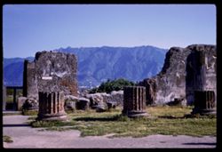
- Subject:
- Walls, Archaeological sites, Grasses, Volcanoes, Pompeii (Extinct city), Ruins, Mountains, and Columns
- Series:
- 12-60
- Creator:
- Cushman, Charles W., 1896-1972
- Date Created:
- 1960-05-26
- Genre:
- Landscape photographs, Cityscape photographs, and Architectural photographs
- Frame Number:
- 17
- County:
- Naples
- Abstract:
- Pompeii
- Call Number:
- P11261
- City:
- Pompeii
- Country:
- Italy
- State/Province:
- Campania
- Alternate Identifier:
- 1260.17
- Persistent URL:
- http://purl.dlib.indiana.edu/iudl/archives/cushman/P11261
- Holding Location:
- Bloomington - University Archives
Wells Library E460
1320 E 10th St.
Bloomington, IN 47405
Contact at archives@indiana.edu, 812-855-1127
-
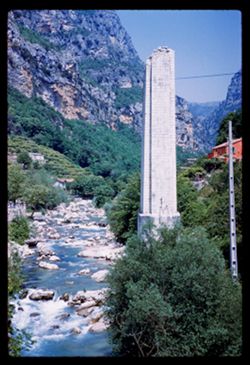
- Subject:
- Ruins, Pilasters, Valleys, Houses, Mountains, Loup River (France), Trees, Rocks, and Rivers
- Series:
- 8-60
- Creator:
- Cushman, Charles W., 1896-1972
- Date Created:
- 1960-05-16
- Genre:
- Landscape photographs
- Frame Number:
- 17
- County:
- Alpes-Maritimes
- Abstract:
- at Pont du Loup
- Call Number:
- P11117
- City:
- La Colle-sur-Loup
- Country:
- France
- State/Province:
- Provence-Alpes-Côte d'Azur
- Alternate Identifier:
- 860.17
- Persistent URL:
- http://purl.dlib.indiana.edu/iudl/archives/cushman/P11117
- Holding Location:
- Bloomington - University Archives
Wells Library E460
1320 E 10th St.
Bloomington, IN 47405
Contact at archives@indiana.edu, 812-855-1127
-
- Description:
- 200 f 4
- Subject:
- Air France, Hills, Roads, Mountains, Shadows, Clouds, and Air travel
- Series:
- 3-60
- Creator:
- Cushman, Charles W., 1896-1972
- Date Created:
- 1960-05-07
- Genre:
- Aerial photographs, Landscape photographs, and Cityscape photographs
- Frame Number:
- 17
- Abstract:
- Dark red& green
- Call Number:
- P10977
- Country:
- United States
- Alternate Identifier:
- 360.17
- Persistent URL:
- http://purl.dlib.indiana.edu/iudl/archives/cushman/P10977
- Holding Location:
- Bloomington - University Archives
Wells Library E460
1320 E 10th St.
Bloomington, IN 47405
Contact at archives@indiana.edu, 812-855-1127
-
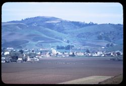
- Description:
- 100 f 4 TL
- Subject:
- Croplands, Streets, Houses, Agricultural machinery & implements, Mountains, Trees, Farms, Farming, and Hills
- Series:
- 2-60
- Creator:
- Cushman, Charles W., 1896-1972
- Date Created:
- 1960-03-10
- Genre:
- Cityscape photographs
- Frame Number:
- 17
- County:
- San Mateo
- Call Number:
- P10948
- City:
- Pescadero
- Country:
- United States
- State/Province:
- California
- Alternate Identifier:
- 260.17
- Persistent URL:
- http://purl.dlib.indiana.edu/iudl/archives/cushman/P10948
- Holding Location:
- Bloomington - University Archives
Wells Library E460
1320 E 10th St.
Bloomington, IN 47405
Contact at archives@indiana.edu, 812-855-1127
-
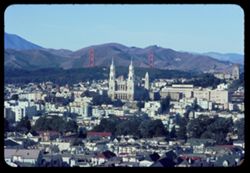
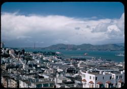
- Description:
- 100 f 11 tl
- Subject:
- Towers, Bell towers, Olympus, Mount (San Francisco County, Calif.), Golden Gate Bridge (San Francisco, Calif.), Suspension bridges, Mountains, Buildings, Bri...
- Series:
- 17-59
- Creator:
- Cushman, Charles W., 1896-1972
- Date Created:
- 1959-12-13
- Genre:
- Cityscape photographs
- Frame Number:
- 17
- County:
- San Francisco
- Abstract:
- G.G. Bridge
- Call Number:
- P10890
- City:
- San Francisco
- Country:
- United States
- State/Province:
- California
- Physical Description:
- Anscochrome film.
- Alternate Identifier:
- 1759.17
- Persistent URL:
- http://purl.dlib.indiana.edu/iudl/archives/cushman/P10890
- Holding Location:
- Bloomington - University Archives
Wells Library E460
1320 E 10th St.
Bloomington, IN 47405
Contact at archives@indiana.edu, 812-855-1127
-
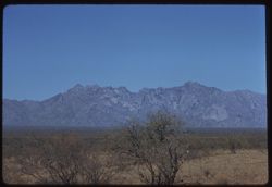
- Description:
- 100 f 9 tl
- Subject:
- Baboquivari Peak (Ariz.), Mountains, Shrubs, and Grasses
- Series:
- 6-59
- Creator:
- Cushman, Charles W., 1896-1972
- Date Created:
- 1959-01-28
- Genre:
- Landscape photographs
- Frame Number:
- 17
- County:
- Pima
- Abstract:
- Broadside view of Babo. range further north of PK.
- Call Number:
- P10555
- Country:
- United States
- State/Province:
- Arizona
- Alternate Identifier:
- 659.17
- Persistent URL:
- http://purl.dlib.indiana.edu/iudl/archives/cushman/P10555
- Holding Location:
- Bloomington - University Archives
Wells Library E460
1320 E 10th St.
Bloomington, IN 47405
Contact at archives@indiana.edu, 812-855-1127
-
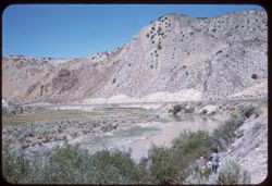
- Description:
- 50 f 8 sl
- Subject:
- Humboldt River (Nev.), Mountains, Shrubs, People, and Rivers
- Series:
- 15-58
- Creator:
- Cushman, Charles W., 1896-1972
- Date Created:
- 1958-08-23
- Genre:
- Landscape photographs
- Frame Number:
- 17
- County:
- Elko
- Abstract:
- Horseshoe Bend of Humboldt river
- Call Number:
- P10123
- Country:
- United States
- State/Province:
- Nevada
- Alternate Identifier:
- 1558.17
- Persistent URL:
- http://purl.dlib.indiana.edu/iudl/archives/cushman/P10123
- Holding Location:
- Bloomington - University Archives
Wells Library E460
1320 E 10th St.
Bloomington, IN 47405
Contact at archives@indiana.edu, 812-855-1127
-
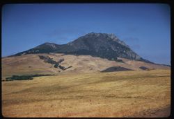
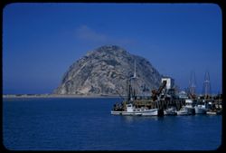
- Description:
- 100 f 6.3 sl hf
- Subject:
- Meadows, Morro Bay (Calif.), Hills, Mountains, and Hollister Peak (Calif.)
- Series:
- 14-58
- Creator:
- Cushman, Charles W., 1896-1972
- Date Created:
- 1958-07-28
- Genre:
- Landscape photographs
- Frame Number:
- 17
- County:
- San Luis Obispo
- Abstract:
- Hollister Pk. between S. Luis O. to Morro B.
- Call Number:
- P10102
- City:
- San Luis Obispo
- Country:
- United States
- State/Province:
- California
- Alternate Identifier:
- 1458.17
- Persistent URL:
- http://purl.dlib.indiana.edu/iudl/archives/cushman/P10102
- Holding Location:
- Bloomington - University Archives
Wells Library E460
1320 E 10th St.
Bloomington, IN 47405
Contact at archives@indiana.edu, 812-855-1127
-
- Description:
- 100 f 7 TL
- Subject:
- Mountains, Dirt roads, Trees, Plants, Rock formations, and Clouds
- Series:
- 11-58
- Creator:
- Cushman, Charles W., 1896-1972
- Date Created:
- 1958-06-14
- Genre:
- Landscape photographs
- Frame Number:
- 17
- Street Address:
- United States Highway 20
- County:
- Malheur
- Abstract:
- Rock like a pussy cat - east of Vale
- Call Number:
- P09992
- City:
- Vale
- Country:
- United States
- State/Province:
- Oregon
- Alternate Identifier:
- 1158.17
- Persistent URL:
- http://purl.dlib.indiana.edu/iudl/archives/cushman/P09992
- Holding Location:
- Bloomington - University Archives
Wells Library E460
1320 E 10th St.
Bloomington, IN 47405
Contact at archives@indiana.edu, 812-855-1127
-
- Description:
- 100 f 8 TL
- Subject:
- Snow, Snow Mountain (Shasta County, Calif.), Mountains, Clouds, Hills, and Plants
- Series:
- 10-58
- Creator:
- Cushman, Charles W., 1896-1972
- Date Created:
- 1958-06-13
- Genre:
- Landscape photographs
- Frame Number:
- 17
- Street Address:
- United States Highway 299
- County:
- Shasta
- Abstract:
- Snow Mtn from US 299
- Call Number:
- P09956
- Country:
- United States
- State/Province:
- California
- Alternate Identifier:
- 1058.17
- Persistent URL:
- http://purl.dlib.indiana.edu/iudl/archives/cushman/P09956
- Holding Location:
- Bloomington - University Archives
Wells Library E460
1320 E 10th St.
Bloomington, IN 47405
Contact at archives@indiana.edu, 812-855-1127
-
- Description:
- 100 f 5.6 tl
- Subject:
- Canyons, Snow Canyon (Washington County, Utah), Mountains, Sagebrush, Herbs, Grasses, and Rock formations
- Series:
- 8-58
- Creator:
- Cushman, Charles W., 1896-1972
- Date Created:
- 1958-04-29
- Genre:
- Landscape photographs
- Frame Number:
- 17
- County:
- Washington
- Abstract:
- Floor of Snow's canyon
- Call Number:
- P09902
- City:
- Saint George
- Country:
- United States
- State/Province:
- Utah
- Alternate Identifier:
- 858.17
- Persistent URL:
- http://purl.dlib.indiana.edu/iudl/archives/cushman/P09902
- Holding Location:
- Bloomington - University Archives
Wells Library E460
1320 E 10th St.
Bloomington, IN 47405
Contact at archives@indiana.edu, 812-855-1127
-
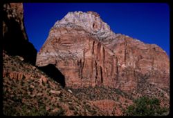
- Description:
- 100 f 6.3 sl
- Subject:
- Canyons, Cliffs, Trees, Swing bridge, Grotto Campground (Utah), Mountains, Shrubs, Zion National Park (Utah), Rivers, National parks & reserves, and Rock...
- Series:
- 7-58
- Creator:
- Cushman, Charles W., 1896-1972
- Date Created:
- 1958-04-28
- Genre:
- Landscape photographs
- Frame Number:
- 17
- County:
- Washington
- Abstract:
- View downstream from Swing Bridge at Grotto Campground
- Call Number:
- P09870
- Country:
- United States
- State/Province:
- Utah
- Alternate Identifier:
- 758.17
- Persistent URL:
- http://purl.dlib.indiana.edu/iudl/archives/cushman/P09870
- Holding Location:
- Bloomington - University Archives
Wells Library E460
1320 E 10th St.
Bloomington, IN 47405
Contact at archives@indiana.edu, 812-855-1127
-
- Description:
- 100 f 8 sl
- Subject:
- Rocks, Cliffs, Mountains, Rock formations, Zion National Park (Utah), East Temple (Utah), Plants, and National parks & reserves
- Series:
- 5-58
- Creator:
- Cushman, Charles W., 1896-1972
- Date Created:
- 1958-04-26
- Genre:
- Landscape photographs
- Frame Number:
- 17
- County:
- Washington
- Abstract:
- East Temple
- Call Number:
- P09805
- Country:
- United States
- State/Province:
- Utah
- Alternate Identifier:
- 558.17
- Persistent URL:
- http://purl.dlib.indiana.edu/iudl/archives/cushman/P09805
- Holding Location:
- Bloomington - University Archives
Wells Library E460
1320 E 10th St.
Bloomington, IN 47405
Contact at archives@indiana.edu, 812-855-1127
-
- Description:
- 100 f8 tl
- Subject:
- Deserts, Mojave Desert (Calif.), Mountains, Calico Mountains (Calif.), Plants, and Rock formations
- Series:
- 3-58
- Creator:
- Cushman, Charles W., 1896-1972
- Date Created:
- 1958-04-25
- Genre:
- Landscape photographs
- Frame Number:
- 17
- County:
- San Bernardino
- Abstract:
- Colorful Calico Mtns. near Yermo
- Call Number:
- P09733
- City:
- Barstow and Yermo
- Country:
- United States
- State/Province:
- California
- Alternate Identifier:
- 358.17
- Persistent URL:
- http://purl.dlib.indiana.edu/iudl/archives/cushman/P09733
- Holding Location:
- Bloomington - University Archives
Wells Library E460
1320 E 10th St.
Bloomington, IN 47405
Contact at archives@indiana.edu, 812-855-1127
-
- Description:
- 100 f 8 ? - shutter was left at 1/50 in error
- Subject:
- Monuments & memorials, Historic buildings, Galleries & museums, Meadows, Mountains, State parks & reserves, Hearst Castle (Calif.), Hills, Castle...
- Series:
- 15-57
- Creator:
- Cushman, Charles W., 1896-1972
- Date Created:
- 1957-09-22
- Genre:
- Landscape photographs
- Frame Number:
- 17
- County:
- San Luis Obispo
- Abstract:
- Hearst's Castle - San Simeon - from coast
- Call Number:
- P09548
- City:
- San Simeon
- Country:
- United States
- State/Province:
- California
- Alternate Identifier:
- 1557.17
- Persistent URL:
- http://purl.dlib.indiana.edu/iudl/archives/cushman/P09548
- Holding Location:
- Bloomington - University Archives
Wells Library E460
1320 E 10th St.
Bloomington, IN 47405
Contact at archives@indiana.edu, 812-855-1127
-
- Description:
- 100 f 4.5
- Subject:
- Valleys, Santa Lucia Range (Calif.), Trees, Meadows, Mountains, and Hills
- Series:
- 13-57
- Creator:
- Cushman, Charles W., 1896-1972
- Date Created:
- 1957-09-18
- Genre:
- Landscape photographs
- Frame Number:
- 17
- Street Address:
- Adelaida Road
- County:
- San Luis Obispo
- Abstract:
- Views from high pt. of Paso Robles - Adelaida road at 5:35 pm
- Call Number:
- P09496
- City:
- Paso Robles
- Country:
- United States
- State/Province:
- California
- Alternate Identifier:
- 1357.17
- Persistent URL:
- http://purl.dlib.indiana.edu/iudl/archives/cushman/P09496
- Holding Location:
- Bloomington - University Archives
Wells Library E460
1320 E 10th St.
Bloomington, IN 47405
Contact at archives@indiana.edu, 812-855-1127
-
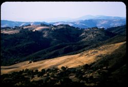
- Description:
- 100 f 6.3 tl
- Subject:
- Plains, Valleys, Yuba Pass (Sierra County, Calif.), Mountains, Trees, and Bear Valley (Sierra County, Calif.)
- Series:
- 11-57
- Creator:
- Cushman, Charles W., 1896-1972
- Date Created:
- 1957-07-23
- Genre:
- Landscape photographs
- Frame Number:
- 17
- County:
- Sierra
- Abstract:
- Down into the Bear Valley from Yuba Pass
- Call Number:
- P09426
- Country:
- United States
- State/Province:
- California
- Alternate Identifier:
- 1157.17
- Persistent URL:
- http://purl.dlib.indiana.edu/iudl/archives/cushman/P09426
- Holding Location:
- Bloomington - University Archives
Wells Library E460
1320 E 10th St.
Bloomington, IN 47405
Contact at archives@indiana.edu, 812-855-1127
-
- Description:
- 100 f 4.5
- Subject:
- Valleys, Tehachapi Mountains (Calif.), Trees, Meadows, Mountains, Clouds, and Hills
- Series:
- 7-57
- Creator:
- Cushman, Charles W., 1896-1972
- Date Created:
- 1957-05-14
- Genre:
- Landscape photographs
- Frame Number:
- 17
- Street Address:
- United States Highway 466
- County:
- Kern
- Abstract:
- Folds in Tehachapi Mtns.
- Call Number:
- P09296
- City:
- Tehachapi
- Country:
- United States
- State/Province:
- California
- Alternate Identifier:
- 757.17
- Persistent URL:
- http://purl.dlib.indiana.edu/iudl/archives/cushman/P09296
- Holding Location:
- Bloomington - University Archives
Wells Library E460
1320 E 10th St.
Bloomington, IN 47405
Contact at archives@indiana.edu, 812-855-1127
-
- Description:
- 100 f 5.6 tl
- Subject:
- Rocks, Oceans, Seas, Cliffs, Coastlines, Pacific Ocean, Arches, Mountains, Rock formations, Bridges, Rocky Point (Monterey County, Calif.), Rocky Creek Bridg...
- Series:
- 5-57
- Creator:
- Cushman, Charles W., 1896-1972
- Date Created:
- 1957-05-09
- Genre:
- Landscape photographs
- Frame Number:
- 17
- County:
- Monterey
- Abstract:
- Green Mt. back of Rocky Ck. bridge
- Call Number:
- P09222
- Country:
- United States
- State/Province:
- California
- Alternate Identifier:
- 557.17
- Persistent URL:
- http://purl.dlib.indiana.edu/iudl/archives/cushman/P09222
- Holding Location:
- Bloomington - University Archives
Wells Library E460
1320 E 10th St.
Bloomington, IN 47405
Contact at archives@indiana.edu, 812-855-1127
-
- Description:
- 100 f 6.3
- Subject:
- Novato Creek Dam (Calif.), Little Mountain (Marin County, Calif.), Hills, Mountains, Reservoirs, and Meadows
- Series:
- 4-57
- Creator:
- Cushman, Charles W., 1896-1972
- Date Created:
- 1957-04-25
- Genre:
- Landscape photographs
- Frame Number:
- 17
- County:
- Marin
- Abstract:
- Green Hill above Novato Dam (Little Mtn.)
- Call Number:
- P09201
- Country:
- United States
- State/Province:
- California
- Alternate Identifier:
- 457.17
- Persistent URL:
- http://purl.dlib.indiana.edu/iudl/archives/cushman/P09201
- Holding Location:
- Bloomington - University Archives
Wells Library E460
1320 E 10th St.
Bloomington, IN 47405
Contact at archives@indiana.edu, 812-855-1127
-
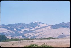
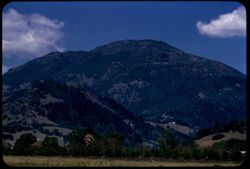
- Description:
- 100 f 8 tl
- Subject:
- Meadows, Saint Helena, Mount (Calif.), Mountains, and Hills
- Series:
- 2-57
- Creator:
- Cushman, Charles W., 1896-1972
- Date Created:
- 1957-04-02
- Genre:
- Landscape photographs
- Frame Number:
- 17
- Street Address:
- United States Highway 128
- County:
- Sonoma
- Abstract:
- Top of Mt. St. Helena from west - (on Hwy 128)
- Call Number:
- P09143
- Country:
- United States
- State/Province:
- California
- Alternate Identifier:
- 257.17
- Persistent URL:
- http://purl.dlib.indiana.edu/iudl/archives/cushman/P09143
- Holding Location:
- Bloomington - University Archives
Wells Library E460
1320 E 10th St.
Bloomington, IN 47405
Contact at archives@indiana.edu, 812-855-1127
-
- Description:
- 100 f 4 tl
- Subject:
- Trees, Mountains, and Clouds
- Series:
- 10-56
- Creator:
- Cushman, Charles W., 1896-1972
- Date Created:
- 1956-07-13
- Genre:
- Landscape photographs
- Frame Number:
- 17
- County:
- Jackson
- Abstract:
- Mtns. north of Ashland
- Call Number:
- P08877
- City:
- Ashland
- Country:
- United States
- State/Province:
- Oregon
- Alternate Identifier:
- 1056.17
- Persistent URL:
- http://purl.dlib.indiana.edu/iudl/archives/cushman/P08877
- Holding Location:
- Bloomington - University Archives
Wells Library E460
1320 E 10th St.
Bloomington, IN 47405
Contact at archives@indiana.edu, 812-855-1127
-
- Description:
- 100 f 5.6 tl
- Subject:
- Bays (Bodies of water), Golden Gate Bridge (San Francisco, Calif.), Suspension bridges, Coastlines, Boars, Mountains, USS Bon Homme Richard, Aircraft carrier...
- Series:
- 7-56
- Creator:
- Cushman, Charles W., 1896-1972
- Date Created:
- 1956-06-08
- Genre:
- Marine photographs
- Frame Number:
- 17
- County:
- San Francisco
- Abstract:
- ( 31 is Bon Homme Rich again )
- Call Number:
- P08764
- City:
- San Francisco
- Country:
- United States
- State/Province:
- California
- Alternate Identifier:
- 756.17
- Persistent URL:
- http://purl.dlib.indiana.edu/iudl/archives/cushman/P08764
- Holding Location:
- Bloomington - University Archives
Wells Library E460
1320 E 10th St.
Bloomington, IN 47405
Contact at archives@indiana.edu, 812-855-1127
-
- Description:
- 100 f 8 TL
- Subject:
- Buck Ridge (San Benito County, Calif.), Mountains, Shrubs, Hills, and Trees
- Series:
- 6-56
- Creator:
- Cushman, Charles W., 1896-1972
- Date Created:
- 1956-04-22
- Genre:
- Landscape photographs
- Frame Number:
- 17
- County:
- San Benito
- Abstract:
- San Benito county hills Buck Ridge between Bitterwater & San Benito
- Call Number:
- P08726
- City:
- San Benito and Bitterwater
- Country:
- United States
- State/Province:
- California
- Alternate Identifier:
- 656.17
- Persistent URL:
- http://purl.dlib.indiana.edu/iudl/archives/cushman/P08726
- Holding Location:
- Bloomington - University Archives
Wells Library E460
1320 E 10th St.
Bloomington, IN 47405
Contact at archives@indiana.edu, 812-855-1127
-
- Description:
- 100 f 6 sl
- Subject:
- Bays (Bodies of water), Piers & wharves, Boats, Morro Rock (Calif.), Morro Bay (Calif.), Mountains, Harbors, and Rock formations
- Series:
- 4-56
- Creator:
- Cushman, Charles W., 1896-1972
- Date Created:
- 1956-04-19
- Genre:
- Marine photographs
- Frame Number:
- 17
- County:
- San Luis Obispo
- Abstract:
- Morro Rock
- Call Number:
- P08656
- Country:
- United States
- State/Province:
- California
- Alternate Identifier:
- 456.17
- Persistent URL:
- http://purl.dlib.indiana.edu/iudl/archives/cushman/P08656
- Holding Location:
- Bloomington - University Archives
Wells Library E460
1320 E 10th St.
Bloomington, IN 47405
Contact at archives@indiana.edu, 812-855-1127
-
- Description:
- 100 f 5.6 tl
- Subject:
- Mountains, Light, Clouds, and Sierra Nevada (Calif. and Nev.)
- Series:
- 26-55
- Creator:
- Cushman, Charles W., 1896-1972
- Date Created:
- 1955-09-25
- Genre:
- Landscape photographs
- Frame Number:
- 17
- Street Address:
- United States Highway 6 and United States Highway 395
- County:
- Inyo
- Abstract:
- Backdrop of high Sierra from US 6/395 between Independence & Big Pine (back ltd)
- Call Number:
- P08400
- City:
- Big Pine and Independence
- Country:
- United States
- State/Province:
- California
- Alternate Identifier:
- 2655.17
- Persistent URL:
- http://purl.dlib.indiana.edu/iudl/archives/cushman/P08400
- Holding Location:
- Bloomington - University Archives
Wells Library E460
1320 E 10th St.
Bloomington, IN 47405
Contact at archives@indiana.edu, 812-855-1127
-
- Description:
- 100 f 6.3 TL
- Subject:
- Sonora Pass (Calif.), Shadows, Mountains, Clouds, Monitor Pass (Calif.), and Sonora Mountains (Calif.)
- Series:
- 25-55
- Creator:
- Cushman, Charles W., 1896-1972
- Date Created:
- 1955-09-24
- Genre:
- Landscape photographs
- Frame Number:
- 17
- Street Address:
- California State Highway 89
- County:
- Alpine and Mono
- Abstract:
- View south toward Sonora mtns
- Call Number:
- P08365
- City:
- Coleville
- Country:
- United States
- State/Province:
- California
- Alternate Identifier:
- 2555.17
- Persistent URL:
- http://purl.dlib.indiana.edu/iudl/archives/cushman/P08365
- Holding Location:
- Bloomington - University Archives
Wells Library E460
1320 E 10th St.
Bloomington, IN 47405
Contact at archives@indiana.edu, 812-855-1127
-
- Description:
- 100 f 5.6 SL
- Subject:
- Thurston Lake (Calif.), Clear Lake (Lake County, Calif.), Konocti, Mount (Calif.), Mountains, Trees, Plants, and Lakes & ponds
- Series:
- 24-55
- Creator:
- Cushman, Charles W., 1896-1972
- Date Created:
- 1955-08-11
- Genre:
- Landscape photographs
- Frame Number:
- 17
- County:
- Lake
- Abstract:
- Mt Konocti and Thurston Lake (cfr. #16)
- Call Number:
- P08326
- Country:
- United States
- State/Province:
- California
- Alternate Identifier:
- 2455.17
- Persistent URL:
- http://purl.dlib.indiana.edu/iudl/archives/cushman/P08326
- Holding Location:
- Bloomington - University Archives
Wells Library E460
1320 E 10th St.
Bloomington, IN 47405
Contact at archives@indiana.edu, 812-855-1127
-
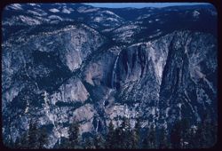
- Description:
- 100 f 8 sl
- Subject:
- National parks & reserves, Half Dome (Calif.), Cliffs, Mountains, Yosemite National Park (Calif.), Waterfalls, Trees, and Yosemite Falls (Calif.)
- Series:
- 21-55
- Creator:
- Cushman, Charles W., 1896-1972
- Date Created:
- 1955-07-08
- Genre:
- Landscape photographs
- Frame Number:
- 17
- County:
- Mariposa
- Abstract:
- Yosemite Falls
- Call Number:
- P08235
- Country:
- United States
- State/Province:
- California
- Alternate Identifier:
- 2155.17
- Persistent URL:
- http://purl.dlib.indiana.edu/iudl/archives/cushman/P08235
- Holding Location:
- Bloomington - University Archives
Wells Library E460
1320 E 10th St.
Bloomington, IN 47405
Contact at archives@indiana.edu, 812-855-1127
-
- Description:
- 100 f 8 tl
- Subject:
- Valleys, Trees, Half Dome (Calif.), Mountains, and Clouds
- Series:
- 20-55
- Creator:
- Cushman, Charles W., 1896-1972
- Date Created:
- 1955-07-07
- Genre:
- Landscape photographs
- Frame Number:
- 17
- County:
- Mariposa
- Abstract:
- View east (to right of Half Dome)
- Call Number:
- P08200
- Country:
- United States
- State/Province:
- California
- Alternate Identifier:
- 2055.17
- Persistent URL:
- http://purl.dlib.indiana.edu/iudl/archives/cushman/P08200
- Holding Location:
- Bloomington - University Archives
Wells Library E460
1320 E 10th St.
Bloomington, IN 47405
Contact at archives@indiana.edu, 812-855-1127
-

- Description:
- 100 f 5.6
- Subject:
- Trinity River (Calif.), Trees, Mountains, Shrubs, and Clouds
- Series:
- 16-55
- Creator:
- Cushman, Charles W., 1896-1972
- Date Created:
- 1955-06-15
- Genre:
- Landscape photographs
- Frame Number:
- 17
- County:
- Trinity
- Abstract:
- Opp. Bank of Trinity - co clouds
- Call Number:
- P08061
- Country:
- United States
- State/Province:
- California
- Alternate Identifier:
- 1655.17
- Persistent URL:
- http://purl.dlib.indiana.edu/iudl/archives/cushman/P08061
- Holding Location:
- Bloomington - University Archives
Wells Library E460
1320 E 10th St.
Bloomington, IN 47405
Contact at archives@indiana.edu, 812-855-1127
-
- Description:
- 100 f 6.3 tl
- Subject:
- Croplands, Roads, Saint Helena, Mount (Calif.), Mountains, Dwellings, Trees, Plants, and Clouds
- Series:
- 15-55
- Creator:
- Cushman, Charles W., 1896-1972
- Date Created:
- 1955-05-17
- Genre:
- Landscape photographs
- Frame Number:
- 17
- County:
- Napa
- Abstract:
- Mt St Helena - from north edge of Calistoga
- Call Number:
- P08025
- City:
- Calistoga
- Country:
- United States
- State/Province:
- California
- Alternate Identifier:
- 1555.17
- Persistent URL:
- http://purl.dlib.indiana.edu/iudl/archives/cushman/P08025
- Holding Location:
- Bloomington - University Archives
Wells Library E460
1320 E 10th St.
Bloomington, IN 47405
Contact at archives@indiana.edu, 812-855-1127
-
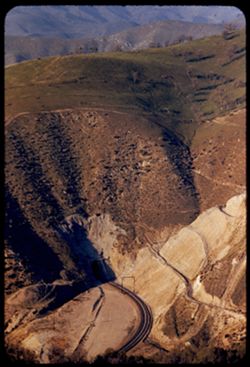
- Description:
- 100 f 4.5 tl
- Subject:
- Roads, Tehachapi Mountains (Calif.), Southern Pacific Tunnel, Trees, Mountains, Tunnels, Railroad tracks, Hills, Utility poles, and Shrubs
- Series:
- 12-55
- Creator:
- Cushman, Charles W., 1896-1972
- Date Created:
- 1955-03-24
- Genre:
- Landscape photographs
- Frame Number:
- 17
- Street Address:
- United States Highway 466
- County:
- Kern
- Abstract:
- S P curves, [cut] and tunnel mouth from same vantage point
- Call Number:
- P07913
- City:
- Keene
- Country:
- United States
- State/Province:
- California
- Alternate Identifier:
- 1255.17
- Persistent URL:
- http://purl.dlib.indiana.edu/iudl/archives/cushman/P07913
- Holding Location:
- Bloomington - University Archives
Wells Library E460
1320 E 10th St.
Bloomington, IN 47405
Contact at archives@indiana.edu, 812-855-1127
-
- Description:
- 100 f 6.3
- Subject:
- Canyons, Valleys, Black Mountains (Inyo County, Calif.), and Mountains
- Series:
- 3-55
- Creator:
- Cushman, Charles W., 1896-1972
- Date Created:
- 1955-02-27
- Genre:
- Landscape photographs
- Frame Number:
- 17
- Street Address:
- Bad Water Road
- County:
- Inyo
- Abstract:
- From a mile or two farther south
- Call Number:
- P07609
- Country:
- United States
- State/Province:
- California
- Alternate Identifier:
- 355.17
- Persistent URL:
- http://purl.dlib.indiana.edu/iudl/archives/cushman/P07609
- Holding Location:
- Bloomington - University Archives
Wells Library E460
1320 E 10th St.
Bloomington, IN 47405
Contact at archives@indiana.edu, 812-855-1127
-
- Description:
- 100 f 4.5 tl
- Subject:
- Rocks, Reservoirs, Trees, Isabella Lake (Calif. : Lake), Mountains, Shrubs, Lakes & ponds, Clouds, and Hills
- Series:
- 2-55
- Creator:
- Cushman, Charles W., 1896-1972
- Date Created:
- 1955-02-26
- Genre:
- Landscape photographs
- Frame Number:
- 17
- County:
- Kern
- Abstract:
- Tops of trees in Isabella reservoir
- Call Number:
- P07575
- City:
- Lake Isabella
- Country:
- United States
- State/Province:
- California
- Alternate Identifier:
- 255.17
- Persistent URL:
- http://purl.dlib.indiana.edu/iudl/archives/cushman/P07575
- Holding Location:
- Bloomington - University Archives
Wells Library E460
1320 E 10th St.
Bloomington, IN 47405
Contact at archives@indiana.edu, 812-855-1127
-
- Description:
- 50 f 9 HF
- Subject:
- Deserts, Owens Valley (Calif.), Mountains, Shrubs, and Sierra Nevada (Calif. and Nev.)
- Series:
- 12-54
- Creator:
- Cushman, Charles W., 1896-1972
- Date Created:
- 1954-09-18
- Genre:
- Landscape photographs
- Frame Number:
- 17
- Street Address:
- United States Highway 6 and United States Highway 395
- County:
- Inyo
- Abstract:
- To show sawteeth - 13 mi. north of Independence.
- Call Number:
- P07407
- City:
- Big Pine and Independence
- Country:
- United States
- State/Province:
- California
- Alternate Identifier:
- 1254.17
- Persistent URL:
- http://purl.dlib.indiana.edu/iudl/archives/cushman/P07407
- Holding Location:
- Bloomington - University Archives
Wells Library E460
1320 E 10th St.
Bloomington, IN 47405
Contact at archives@indiana.edu, 812-855-1127
-
- Description:
- 50 f 9
- Subject:
- Sabrina, Lake (Calif.), Canyons, Roads, Settlements, Mountains, Shrubs, Sierra Nevada (Calif. and Nev.), Trees, Rocks, Bishop Creek Canyon (Calif.), and Dwel...
- Series:
- 11-54
- Creator:
- Cushman, Charles W., 1896-1972
- Date Created:
- 1954-09-17
- Genre:
- Landscape photographs
- Frame Number:
- 17
- County:
- Inyo
- Abstract:
- Back up Bishop Creek canyon in fall color.
- Call Number:
- P07386
- Country:
- United States
- State/Province:
- California
- Alternate Identifier:
- 1154.17
- Persistent URL:
- http://purl.dlib.indiana.edu/iudl/archives/cushman/P07386
- Holding Location:
- Bloomington - University Archives
Wells Library E460
1320 E 10th St.
Bloomington, IN 47405
Contact at archives@indiana.edu, 812-855-1127
-
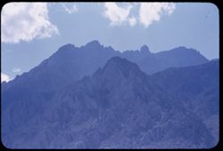
- Description:
- 50 f 11
- Subject:
- Sawtooth Ridge (Calif.), Twin Peaks (San Francisco County, Calif.), Dirt roads, Flowers, Matterhorn Peak (Calif.), Mountains, Shrubs, Sierra Nevada (Calif. a...
- Series:
- 9-54
- Creator:
- Cushman, Charles W., 1896-1972
- Date Created:
- 1954-09-16
- Genre:
- Landscape photographs
- Frame Number:
- 17
- Street Address:
- United States Highway 395
- County:
- Mono
- Abstract:
- Matterhorn and Twin Peaks from Hwy 395 to NE (?). Mountains of Sawtooth Ridge, all over, 11,000 ft.
- Call Number:
- P07328
- City:
- Bridgeport
- Country:
- United States
- State/Province:
- California
- Alternate Identifier:
- 954.17
- Persistent URL:
- http://purl.dlib.indiana.edu/iudl/archives/cushman/P07328
- Holding Location:
- Bloomington - University Archives
Wells Library E460
1320 E 10th St.
Bloomington, IN 47405
Contact at archives@indiana.edu, 812-855-1127
-
- Description:
- 50 f 7
- Subject:
- Trestles, Canyons, Trees, Railroad bridges, Western Pacific Railroad Company, Mountains, Shrubs, and Railroads
- Series:
- 7-54
- Creator:
- Cushman, Charles W., 1896-1972
- Date Created:
- 1954-08-22
- Genre:
- Landscape photographs
- Frame Number:
- 17
- County:
- Plumas
- Abstract:
- WP trestle near Keddie.
- Call Number:
- P07272
- City:
- Keddie
- Country:
- United States
- State/Province:
- California
- Alternate Identifier:
- 754.17
- Persistent URL:
- http://purl.dlib.indiana.edu/iudl/archives/cushman/P07272
- Holding Location:
- Bloomington - University Archives
Wells Library E460
1320 E 10th St.
Bloomington, IN 47405
Contact at archives@indiana.edu, 812-855-1127
-
- Description:
- 50 f 8 Haze Filt
- Subject:
- Sacramento River (Calif.), Mountains, Shrubs, Trees, Clouds, Shasta Lake (Calif.), and Rivers
- Series:
- 6-54
- Creator:
- Cushman, Charles W., 1896-1972
- Date Created:
- 1954-08-20
- Genre:
- Landscape photographs
- Frame Number:
- 17
- Street Address:
- United States Highway 99
- County:
- Shasta
- Abstract:
- Sacramento river from US 99 bridge.
- Call Number:
- P07235
- Country:
- United States
- State/Province:
- California
- Alternate Identifier:
- 654.17
- Persistent URL:
- http://purl.dlib.indiana.edu/iudl/archives/cushman/P07235
- Holding Location:
- Bloomington - University Archives
Wells Library E460
1320 E 10th St.
Bloomington, IN 47405
Contact at archives@indiana.edu, 812-855-1127
-
- Description:
- 50 f 9
- Subject:
- Rocks, Trees, Pines, Lassen Volcanic National Park (Calif.), Helen, Lake (Shasta County, Calif.), Mountains, Shrubs, Lakes & ponds, Glacial lakes, and Snow
- Series:
- 5-54
- Creator:
- Cushman, Charles W., 1896-1972
- Date Created:
- 1954-08-19
- Genre:
- Landscape photographs
- Frame Number:
- 17
- County:
- Shasta
- Abstract:
- view across Helen Lake tall pine
- Call Number:
- P07213
- Country:
- United States
- State/Province:
- California
- Physical Description:
- Anscochrome film.
- Alternate Identifier:
- 554.17
- Persistent URL:
- http://purl.dlib.indiana.edu/iudl/archives/cushman/P07213
- Holding Location:
- Bloomington - University Archives
Wells Library E460
1320 E 10th St.
Bloomington, IN 47405
Contact at archives@indiana.edu, 812-855-1127
-
- Description:
- 50 f 9
- Subject:
- Bodies of water, Weeds, Fishing, Mountains, Shrubs, Lakes & ponds, Clouds, People, Clear Lake (Lake County, Calif.), Grasses, and Plants
- Series:
- 4-54
- Creator:
- Cushman, Charles W., 1896-1972
- Date Created:
- 1954-08-13
- Genre:
- Landscape photographs
- Frame Number:
- 17
- County:
- Lake
- Abstract:
- Clear Lake
- Call Number:
- P07191
- Country:
- United States
- State/Province:
- California
- Physical Description:
- Anscochrome film.
- Alternate Identifier:
- 454.17
- Persistent URL:
- http://purl.dlib.indiana.edu/iudl/archives/cushman/P07191
- Holding Location:
- Bloomington - University Archives
Wells Library E460
1320 E 10th St.
Bloomington, IN 47405
Contact at archives@indiana.edu, 812-855-1127
-
- Description:
- 50 f 6.3 POLA
- Subject:
- Grasses, Cliffs, Trees, Mountains, Shrubs, Hills, Mesas, and Rock formations
- Series:
- 15-53
- Creator:
- Cushman, Charles W., 1896-1972
- Date Created:
- 1953-11-21
- Genre:
- Landscape photographs
- Frame Number:
- 17
- Street Address:
- United States Highway 89A
- County:
- Coconino
- Abstract:
- View NE.
- Call Number:
- P07050
- City:
- Sedona
- Country:
- United States
- State/Province:
- Arizona
- Alternate Identifier:
- 1553.17
- Persistent URL:
- http://purl.dlib.indiana.edu/iudl/archives/cushman/P07050
- Holding Location:
- Bloomington - University Archives
Wells Library E460
1320 E 10th St.
Bloomington, IN 47405
Contact at archives@indiana.edu, 812-855-1127
-
- Description:
- 50 f 6.3
- Subject:
- Tree limbs, Mountains, Trees, and Rocks
- Series:
- 14-53
- Creator:
- Cushman, Charles W., 1896-1972
- Date Created:
- 1953-11-19
- Genre:
- Landscape photographs
- Frame Number:
- 17
- Street Address:
- United States Highway 70 and United States Highway 60
- County:
- Pinal and Gila
- Abstract:
- Top of mtn near US 70 summit
- Call Number:
- P07013
- City:
- Miami and Superior
- Country:
- United States
- State/Province:
- Arizona
- Alternate Identifier:
- 1453.17
- Persistent URL:
- http://purl.dlib.indiana.edu/iudl/archives/cushman/P07013
- Holding Location:
- Bloomington - University Archives
Wells Library E460
1320 E 10th St.
Bloomington, IN 47405
Contact at archives@indiana.edu, 812-855-1127
-
- Description:
- 50 f 8+
- Subject:
- Cotton, Croplands, Plains, Mountains, Trees, Clouds, and Organ Mountains (N.M.)
- Series:
- 13-53
- Creator:
- Cushman, Charles W., 1896-1972
- Date Created:
- 1953-11-17
- Genre:
- Landscape photographs
- Frame Number:
- 17
- County:
- Dona Ana county
- Abstract:
- Cotton, Organ Mtns. & clouds
- Call Number:
- P06974
- City:
- Las Cruces
- Country:
- United States
- State/Province:
- New Mexico
- Alternate Identifier:
- 1353.17
- Persistent URL:
- http://purl.dlib.indiana.edu/iudl/archives/cushman/P06974
- Holding Location:
- Bloomington - University Archives
Wells Library E460
1320 E 10th St.
Bloomington, IN 47405
Contact at archives@indiana.edu, 812-855-1127
-
- Description:
- 50 f 9
- Subject:
- Hills, Mountains, Trees, and Grasses
- Series:
- 9-53
- Creator:
- Cushman, Charles W., 1896-1972
- Date Created:
- 1953-10-11
- Genre:
- Landscape photographs
- Frame Number:
- 17
- Street Address:
- United States Highway 50
- County:
- Utah
- Abstract:
- Up at mtn 4 mi w of Thistle.
- Call Number:
- P06818
- City:
- Thistle
- Country:
- United States
- State/Province:
- Utah
- Alternate Identifier:
- 953.17
- Persistent URL:
- http://purl.dlib.indiana.edu/iudl/archives/cushman/P06818
- Holding Location:
- Bloomington - University Archives
Wells Library E460
1320 E 10th St.
Bloomington, IN 47405
Contact at archives@indiana.edu, 812-855-1127
-
- Description:
- 50 f 8
- Subject:
- Rocks, Grasses, Houses, Trees, Strawberry Lodge, Lodges, Mountains, Shrubs, Sierra Nevada (Calif. and Nev.), Hills, Utility poles, and Roads
- Series:
- 8-53
- Creator:
- Cushman, Charles W., 1896-1972
- Date Created:
- 1953-10-09
- Genre:
- Landscape photographs
- Frame Number:
- 17
- Street Address:
- United States Highway 50
- County:
- El Dorado
- Abstract:
- Shoulder above Strawberry Lodge.
- Call Number:
- P06779
- Country:
- United States
- State/Province:
- California
- Alternate Identifier:
- 853.17
- Persistent URL:
- http://purl.dlib.indiana.edu/iudl/archives/cushman/P06779
- Holding Location:
- Bloomington - University Archives
Wells Library E460
1320 E 10th St.
Bloomington, IN 47405
Contact at archives@indiana.edu, 812-855-1127
-
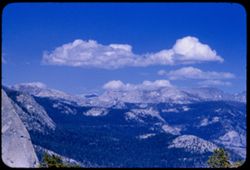
- Description:
- 50 f 5.6 Pola
- Subject:
- National parks & reserves, Sentinel Dome (Calif.), Half Dome (Calif.), Mountains, Yosemite National Park (Calif.), Snow, Trees, and Clouds
- Series:
- 5-53
- Creator:
- Cushman, Charles W., 1896-1972
- Date Created:
- 1953-05-13
- Genre:
- Landscape photographs
- Frame Number:
- 17
- County:
- Mariposa
- Abstract:
- East from Sentinel Dome.
- Call Number:
- P06667
- Country:
- United States
- State/Province:
- California
- Alternate Identifier:
- 553.17
- Persistent URL:
- http://purl.dlib.indiana.edu/iudl/archives/cushman/P06667
- Holding Location:
- Bloomington - University Archives
Wells Library E460
1320 E 10th St.
Bloomington, IN 47405
Contact at archives@indiana.edu, 812-855-1127
-
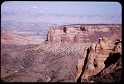
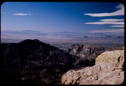
- Description:
- 25 f 11
- Subject:
- Valleys, Bodies of water, Cliffs, Colorado National Monument (Colo.), Mesas, Colorado River (Colo.-Mexico), Shadows, Mountains, Rock formations, Colorado Riv...
- Series:
- 26-52
- Creator:
- Cushman, Charles W., 1896-1972
- Date Created:
- 1952-11-03
- Genre:
- Landscape photographs
- Frame Number:
- 17
- County:
- Mesa
- Abstract:
- view north.
- Call Number:
- P06423
- City:
- Grand Junction
- Country:
- United States
- State/Province:
- Colorado
- Alternate Identifier:
- 2652.17
- Persistent URL:
- http://purl.dlib.indiana.edu/iudl/archives/cushman/P06423
- Holding Location:
- Bloomington - University Archives
Wells Library E460
1320 E 10th St.
Bloomington, IN 47405
Contact at archives@indiana.edu, 812-855-1127
-
- Description:
- 25 f 9
- Subject:
- Rocks, Automobiles, Trees, Mountains, Buildings, Shrubs, Hills, and Utility poles
- Series:
- 24-52
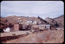
- Creator:
- Cushman, Charles W., 1896-1972
- Date Created:
- 1952-10-31
- Genre:
- Cityscape photographs
- Frame Number:
- 17
- County:
- Gilpin
- Abstract:
- Blackhawk, Colorado.
- Call Number:
- P06348
- City:
- Blackhawk
- Country:
- United States
- State/Province:
- Colorado
- Alternate Identifier:
- 2452.17
- Persistent URL:
- http://purl.dlib.indiana.edu/iudl/archives/cushman/P06348
- Holding Location:
- Bloomington - University Archives
Wells Library E460
1320 E 10th St.
Bloomington, IN 47405
Contact at archives@indiana.edu, 812-855-1127
-
- Description:
- 50 f 6.3
- Subject:
- Snow, Canyons, Cliffs, Trees, Mountains, and Oak Tree Canyon (Ariz.)
- Series:
- 16-52
- Creator:
- Cushman, Charles W., 1896-1972
- Date Created:
- 1952-04-12
- Genre:
- Landscape photographs
- Frame Number:
- 17
- County:
- Pima
- Abstract:
- Entering Oak Tree canyon from north
- Call Number:
- P06075
- Country:
- United States
- State/Province:
- Arizona
- Alternate Identifier:
- 1652.17
- Persistent URL:
- http://purl.dlib.indiana.edu/iudl/archives/cushman/P06075
- Holding Location:
- Bloomington - University Archives
Wells Library E460
1320 E 10th St.
Bloomington, IN 47405
Contact at archives@indiana.edu, 812-855-1127
-
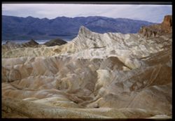
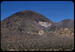
- Description:
- 25 f 8 Pola
- Subject:
- Deserts, Valleys, Cliffs, Mountains, Rock formations, Zabriskie Point (Calif.), and Death Valley (Calif. and Nev.)
- Series:
- 15-52
- Creator:
- Cushman, Charles W., 1896-1972
- Date Created:
- 1952-04-09
- Genre:
- Landscape photographs
- Frame Number:
- 17
- County:
- Inyo
- Abstract:
- West from north of Pt.
- Call Number:
- P06037
- City:
- Furnace Creek
- Country:
- United States
- State/Province:
- California
- Physical Description:
- Image was originally mounted in a glass enclosure. Before digitization, the image was removed and placed in a Wess Plastic, Inc. brand, 2" x 2", pl...
- Alternate Identifier:
- 1552.17
- Persistent URL:
- http://purl.dlib.indiana.edu/iudl/archives/cushman/P06037
- Holding Location:
- Bloomington - University Archives
Wells Library E460
1320 E 10th St.
Bloomington, IN 47405
Contact at archives@indiana.edu, 812-855-1127
-
- Description:
- 25 f 8 Pola
- Subject:
- Croplands, Hills, Whitney, Mount (Calif.), Mountains, Shrubs, Snow, Trees, Farms, Clouds, Agricultural facilities, and Sierra Nevada (Calif. and Nev.)
- Series:
- 14-52
- Creator:
- Cushman, Charles W., 1896-1972
- Date Created:
- 1952-04-08
- Genre:
- Landscape photographs
- Frame Number:
- 17
- County:
- Inyo
- Abstract:
- Mt. Whitney this time.
- Call Number:
- P06001
- City:
- Lone Pine
- Country:
- United States
- State/Province:
- California
- Alternate Identifier:
- 1452.17
- Persistent URL:
- http://purl.dlib.indiana.edu/iudl/archives/cushman/P06001
- Holding Location:
- Bloomington - University Archives
Wells Library E460
1320 E 10th St.
Bloomington, IN 47405
Contact at archives@indiana.edu, 812-855-1127
-
- Description:
- 25 f 6.3 pola
- Subject:
- Bays (Bodies of water), Apartment houses, Golden Gate Bridge (San Francisco, Calif.), Suspension bridges, Roofs, Mountains, Buildings, Clouds, Coit Memorial ...
- Series:
- 10-52
- Creator:
- Cushman, Charles W., 1896-1972
- Date Created:
- 1952-03-12
- Genre:
- Cityscape photographs
- Frame Number:
- 17
- County:
- Marin and San Francisco
- Abstract:
- Golden Gate Bridge from Coit Tower [bse]
- Call Number:
- P05849
- City:
- San Francisco
- Country:
- United States
- State/Province:
- California
- Alternate Identifier:
- 1052.17
- Persistent URL:
- http://purl.dlib.indiana.edu/iudl/archives/cushman/P05849
- Holding Location:
- Bloomington - University Archives
Wells Library E460
1320 E 10th St.
Bloomington, IN 47405
Contact at archives@indiana.edu, 812-855-1127
-
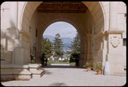
- Description:
- 25 f 8
- Subject:
- Santa Barbara County Courthouse (Santa Barbara, Calif.), Courthouses, Automobiles, Trees, Walkways, Arches, Mountains, Buildings, Shrubs, Plant containers, C...
- Series:
- 8-52
- Creator:
- Cushman, Charles W., 1896-1972
- Date Created:
- 1952-02-28
- Genre:
- Architectural photographs
- Frame Number:
- 17
- County:
- Santa Barbara
- Abstract:
- Mtns seen through Court House arch
- Call Number:
- P05776
- City:
- Santa Barbara
- Country:
- United States
- State/Province:
- California
- Alternate Identifier:
- 852.17
- Persistent URL:
- http://purl.dlib.indiana.edu/iudl/archives/cushman/P05776
- Holding Location:
- Bloomington - University Archives
Wells Library E460
1320 E 10th St.
Bloomington, IN 47405
Contact at archives@indiana.edu, 812-855-1127
-
- Description:
- 50 f 6.3 Pola
- Subject:
- Valleys, Mountains, Tucson Mountains (Ariz.), Sierrita Mountains (Ariz.), Rock formations, and Clouds
- Series:
- 4-52
- Creator:
- Cushman, Charles W., 1896-1972
- Date Created:
- 1952-01-25
- Genre:
- Landscape photographs
- Frame Number:
- 17
- Street Address:
- Mount Lemmon Road
- County:
- Pima
- Abstract:
- View over Tucson from same location
- Call Number:
- P05623
- City:
- Tucson
- Country:
- United States
- State/Province:
- Arizona
- Alternate Identifier:
- 452.17
- Persistent URL:
- http://purl.dlib.indiana.edu/iudl/archives/cushman/P05623
- Holding Location:
- Bloomington - University Archives
Wells Library E460
1320 E 10th St.
Bloomington, IN 47405
Contact at archives@indiana.edu, 812-855-1127
-
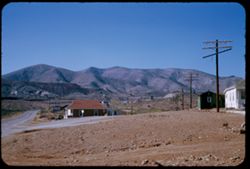
- Description:
- 25 f 11
- Subject:
- Electric lines, Automobiles, Mesas, Streets, Mountains, Buildings, and Utility poles
- Series:
- 1-52
- Creator:
- Cushman, Charles W., 1896-1972
- Date Created:
- 1952-01-04
- Genre:
- Landscape photographs and Views
- Frame Number:
- 17
- County:
- Cochise
- Abstract:
- Nearing Lowell from East.
- Call Number:
- P05507
- City:
- Lowell
- Country:
- United States
- State/Province:
- Arizona
- Alternate Identifier:
- 152.17
- Persistent URL:
- http://purl.dlib.indiana.edu/iudl/archives/cushman/P05507
- Holding Location:
- Bloomington - University Archives
Wells Library E460
1320 E 10th St.
Bloomington, IN 47405
Contact at archives@indiana.edu, 812-855-1127
-
- Description:
- 125 f 4.5
- Subject:
- Horseback riding, Guards, Horses, Men, Hills, Border patrols, Boquillas Canyon (Big Bend National Park (Tex.)), Cliffs, Mountains, Shrubs, Cactus, Mounted po...
- Series:
- 16-51
- Creator:
- Cushman, Charles W., 1896-1972
- Date Created:
- 1951-12-27
- Genre:
- Portraits
- Frame Number:
- 17
- County:
- Brewster
- Abstract:
- Border patrol near Boquillas.
- Call Number:
- P05436
- Country:
- United States
- State/Province:
- Texas
- Alternate Identifier:
- 1651.17
- Persistent URL:
- http://purl.dlib.indiana.edu/iudl/archives/cushman/P05436
- Holding Location:
- Bloomington - University Archives
Wells Library E460
1320 E 10th St.
Bloomington, IN 47405
Contact at archives@indiana.edu, 812-855-1127
-
![Mountain on right bank of Tennessee river about 11 miles west of Lookout Mtn. [from Us 41]](https://iiif.uits.iu.edu/iiif/2/zc77sq452%2Ffiles%2Fa5829f10-a1a5-48af-bd5f-3cf4e4b281c8/full/250,/0/default.jpg)
- Description:
- 25 f 6.3
- Subject:
- Tennessee River, Trees, Mountains, and Rivers
- Series:
- 8-51
- Creator:
- Cushman, Charles W., 1896-1972
- Date Created:
- 1951-12-02
- Genre:
- Landscape photographs
- Frame Number:
- 17
- Street Address:
- United States Highway 41
- Abstract:
- Mtn across Tenn rivver from Hwy 41 miles w of Lookout
- Call Number:
- P05122
- Country:
- United States
- State/Province:
- Tennessee
- Alternate Identifier:
- 851.17
- Persistent URL:
- http://purl.dlib.indiana.edu/iudl/archives/cushman/P05122
- Holding Location:
- Bloomington - University Archives
Wells Library E460
1320 E 10th St.
Bloomington, IN 47405
Contact at archives@indiana.edu, 812-855-1127
-
- Subject:
- Trees, Mountains, and Cadillac Mountain (Me.)
- Series:
- 17-41
- Creator:
- Cushman, Charles W., 1896-1972
- Date Created:
- 1941-09-18
- Genre:
- Landscape photographs
- Frame Number:
- 17
- County:
- Hancock
- Abstract:
- Evergreens and a few fall colors on slope of Cadillac Mtn.
- Call Number:
- P02459
- City:
- Mount Desert Island
- Country:
- United States
- State/Province:
- Maine
- Physical Description:
- Image was originally mounted in a glass enclosure. Before digitization, the image was removed and placed in a Wess Plastic, Inc. brand, 2" x 2", pl...
- Alternate Identifier:
- 1741.17
- Persistent URL:
- http://purl.dlib.indiana.edu/iudl/archives/cushman/P02459
- Holding Location:
- Bloomington - University Archives
Wells Library E460
1320 E 10th St.
Bloomington, IN 47405
Contact at archives@indiana.edu, 812-855-1127
-
- Subject:
- Pedestrians, White Mountains (N.H. and Me.), Cliffs, Trees, Mountains, Shrubs, and Roads
- Series:
- 16-41
- Creator:
- Cushman, Charles W., 1896-1972
- Date Created:
- 1941-09-15
- Genre:
- Landscape photographs
- Frame Number:
- 17
- Abstract:
- Fall colors along a Hwy in White Mtns.
- Call Number:
- P02438
- Country:
- United States
- State/Province:
- New Hampshire
- Physical Description:
- Image was originally mounted in a glass enclosure. Before digitization, the image was removed and placed in a Wess Plastic, Inc. brand, 2" x 2", pl...
- Alternate Identifier:
- 1641.17
- Persistent URL:
- http://purl.dlib.indiana.edu/iudl/archives/cushman/P02438
- Holding Location:
- Bloomington - University Archives
Wells Library E460
1320 E 10th St.
Bloomington, IN 47405
Contact at archives@indiana.edu, 812-855-1127
-
- Subject:
- Automobiles, Roads, Blue Ridge Mountains, Shrubs, Trees, Shadows, Clouds, and Mountains
- Series:
- 18-40
- Creator:
- Cushman, Charles W., 1896-1972
- Date Created:
- 1940-09-27/1940-10-12
- Genre:
- Landscape photographs
- Frame Number:
- 17
- Street Address:
- Skyline Drive
- Abstract:
- Skyline Drive, Blue Ridge, Virginia.
- Call Number:
- P02103
- Country:
- United States
- State/Province:
- Virginia
- Alternate Identifier:
- 1840.17
- Persistent URL:
- http://purl.dlib.indiana.edu/iudl/archives/cushman/P02103
- Holding Location:
- Bloomington - University Archives
Wells Library E460
1320 E 10th St.
Bloomington, IN 47405
Contact at archives@indiana.edu, 812-855-1127
-
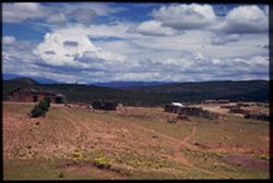
- Subject:
- Mountains, Dirt roads, Dwellings, Trees, Clouds, Wildflowers, Fences, and Shrubs
- Series:
- 13-40
- Creator:
- Cushman, Charles W., 1896-1972
- Date Created:
- 1940-07-18
- Genre:
- Landscape photographs
- Frame Number:
- 17
- County:
- Santa Fe and San Miguel
- Abstract:
- An adobe village off the Santa Fe- Las Vegas highway. Thursday forenoon
- Call Number:
- P02017
- City:
- Las Vegas and Santa Fe
- Country:
- United States
- State/Province:
- New Mexico
- Physical Description:
- Image was originally mounted in a glass enclosure. Before digitization, the image was removed and placed in a Wess Plastic, Inc. brand, 2" x 2", pl...
- Alternate Identifier:
- 1340.17
- Persistent URL:
- http://purl.dlib.indiana.edu/iudl/archives/cushman/P02017
- Holding Location:
- Bloomington - University Archives
Wells Library E460
1320 E 10th St.
Bloomington, IN 47405
Contact at archives@indiana.edu, 812-855-1127
-
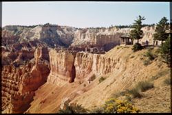
- Subject:
- Wildflowers, Cliffs, Bryce Canyon National Park (Utah), Trails & paths, Trees, Mountains, National parks & reserves, Bryce Canyon (Utah : Valley), Pa...
- Series:
- 11-40
- Creator:
- Cushman, Charles W., 1896-1972
- Date Created:
- 1940-07-12
- Genre:
- Landscape photographs
- Frame Number:
- 17
- County:
- Garfield
- Abstract:
- Bryce Canyon. Looking at sunset Pt. In morning light.
- Call Number:
- P01977
- Country:
- United States
- State/Province:
- Utah
- Physical Description:
- Image was originally mounted in a glass enclosure. Before digitization, the image was removed and placed in a Wess Plastic, Inc. brand, 2" x 2", pl...
- Alternate Identifier:
- 1140.17
- Persistent URL:
- http://purl.dlib.indiana.edu/iudl/archives/cushman/P01977
- Holding Location:
- Bloomington - University Archives
Wells Library E460
1320 E 10th St.
Bloomington, IN 47405
Contact at archives@indiana.edu, 812-855-1127
-
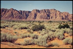
- Subject:
- Trees, Sagebrush, Mountains, National parks & reserves, Zion National Park (Utah), and Shrubs
- Series:
- 10-40
- Creator:
- Cushman, Charles W., 1896-1972
- Date Created:
- 1940-07-10
- Genre:
- Landscape photographs
- Frame Number:
- 17
- County:
- Washington
- Abstract:
- Sage + red earth, en route to Zion.
- Call Number:
- P01939
- Country:
- United States
- State/Province:
- Utah
- Physical Description:
- Image was originally mounted in a glass enclosure. Before digitization, the image was removed and placed in a Wess Plastic, Inc. brand, 2" x 2", pl...
- Alternate Identifier:
- 1040.17
- Persistent URL:
- http://purl.dlib.indiana.edu/iudl/archives/cushman/P01939
- Holding Location:
- Bloomington - University Archives
Wells Library E460
1320 E 10th St.
Bloomington, IN 47405
Contact at archives@indiana.edu, 812-855-1127
-
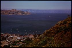
- Subject:
- East Bay Hills (Calif.), Vessels, Islands, Mountains, Angel Island (Calif.), Trees, Dwellings, Bays (Bodies of water), San Francisco Bay (Calif.), Streets, A...
- Series:
- 8-40
- Creator:
- Cushman, Charles W., 1896-1972
- Date Created:
- 1940-07-01
- Genre:
- Views
- Frame Number:
- 17
- County:
- Marin and San Francisco
- Abstract:
- Sausolito, Angel Island, and East Bay Hills.
- Call Number:
- P01900
- City:
- San Francisco and Sausalito
- Country:
- United States
- State/Province:
- California
- Physical Description:
- Image was originally mounted in a glass enclosure. Before digitization, the image was removed and placed in a Wess Plastic, Inc. brand, 2" x 2", pl...
- Alternate Identifier:
- 840.17
- Persistent URL:
- http://purl.dlib.indiana.edu/iudl/archives/cushman/P01900
- Holding Location:
- Bloomington - University Archives
Wells Library E460
1320 E 10th St.
Bloomington, IN 47405
Contact at archives@indiana.edu, 812-855-1127
-
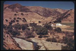
- Subject:
- Valleys, Farmhouses, San Benito River (Calif.), Trees, San Juan Valley (San Benito County and Santa Clara County, Calif.), Mountains, Fences, Shrubs, Agricul...
- Series:
- 7-40
- Creator:
- Cushman, Charles W., 1896-1972
- Date Created:
- 1940-06-21
- Genre:
- Landscape photographs
- Frame Number:
- 17
- County:
- San Benito and Santa Clara
- Abstract:
- California Pastorale. San Benito Valley Duplicated
- Call Number:
- P01878
- Country:
- United States
- State/Province:
- California
- Physical Description:
- Image was originally mounted in a glass enclosure. Before digitization, the image was removed and placed in a Wess Plastic, Inc. brand, 2" x 2", pl...
- Alternate Identifier:
- 740.17
- Persistent URL:
- http://purl.dlib.indiana.edu/iudl/archives/cushman/P01878
- Holding Location:
- Bloomington - University Archives
Wells Library E460
1320 E 10th St.
Bloomington, IN 47405
Contact at archives@indiana.edu, 812-855-1127
-
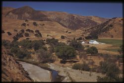
- Subject:
- Valleys, Farmhouses, San Benito River (Calif.), Farms, Trees, San Juan Valley (San Benito County and Santa Clara County, Calif.), Mountains, Fences, Shrubs, ...
- Series:
- 7-40
- Creator:
- Cushman, Charles W., 1896-1972
- Date Created:
- 1940-06-21
- Genre:
- Landscape photographs
- Frame Number:
- 17
- County:
- San Benito and Santa Clara
- Abstract:
- California Pastorale. San Benito Valley Duplicated
- Call Number:
- P01877
- Country:
- United States
- State/Province:
- California
- Physical Description:
- Image was originally mounted in a glass enclosure. Before digitization, the image was removed and placed in a Wess Plastic, Inc. brand, 2" x 2", pl...
- Alternate Identifier:
- 740.17
- Persistent URL:
- http://purl.dlib.indiana.edu/iudl/archives/cushman/P01877
- Holding Location:
- Bloomington - University Archives
Wells Library E460
1320 E 10th St.
Bloomington, IN 47405
Contact at archives@indiana.edu, 812-855-1127
-
- Subject:
- Deserts, Roskruge Mountains (Ariz.), Mountains, Shrubs, Cactus, and Clouds
- Series:
- 5-40
- Creator:
- Cushman, Charles W., 1896-1972
- Date Created:
- 1940-05-01
- Genre:
- Landscape photographs
- Frame Number:
- 17
- County:
- Pima
- Abstract:
- An Arizona desert . Roskruge Mtns. In distance. View is northeast.
- Call Number:
- P01835
- Country:
- United States
- State/Province:
- Arizona
- Physical Description:
- Image was originally mounted in a glass enclosure. Before digitization, the image was removed and placed in a Wess Plastic, Inc. brand, 2" x 2", pl...
- Alternate Identifier:
- 540.17
- Persistent URL:
- http://purl.dlib.indiana.edu/iudl/archives/cushman/P01835
- Holding Location:
- Bloomington - University Archives
Wells Library E460
1320 E 10th St.
Bloomington, IN 47405
Contact at archives@indiana.edu, 812-855-1127
-
- Subject:
- Dirt roads, Adobe buildings, Trees, Shadows, Mountains, Shrubs, Clouds, and Dwellings
- Series:
- 13-40
- Creator:
- Cushman, Charles W., 1896-1972
- Date Created:
- 1940-07-18
- Genre:
- Landscape photographs
- Frame Number:
- 17
- County:
- Santa Fe and San Miguel
- Abstract:
- An adobe village off the Santa Fe- Las Vegas highway. Thursday forenoon
- Call Number:
- P01817
- City:
- Santa Fe and Las Vegas
- Country:
- United States
- State/Province:
- New Mexico
- Physical Description:
- masked. Image was originally mounted in a glass enclosure. Before digitization, the image was removed and placed in a Wess Plastic, Inc. brand, 2" x 2&q...
- Alternate Identifier:
- 1340.17
- Persistent URL:
- http://purl.dlib.indiana.edu/iudl/archives/cushman/P01817
- Holding Location:
- Bloomington - University Archives
Wells Library E460
1320 E 10th St.
Bloomington, IN 47405
Contact at archives@indiana.edu, 812-855-1127
-
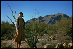
- Subject:
- Rocks, Women, Mountains, Ocotillo, Shrubs, Santa Catalina Mountains (Ariz.), and Cactus
- Series:
- 3-40
- Creator:
- Cushman, Charles W., 1896-1972
- Date Created:
- 1940-03-01
- Genre:
- Portraits and Identification photographs
- Frame Number:
- 17
- County:
- Pima
- Persons Pictured:
- Cushman, Jean
- Abstract:
- Jean and Friendly Ocotillo
- Call Number:
- P01784
- Country:
- United States
- State/Province:
- Arizona
- Physical Description:
- Image was originally mounted in a glass enclosure. Before digitization, the image was removed and placed in a Wess Plastic, Inc. brand, 2" x 2", pl...
- Alternate Identifier:
- 340.17
- Persistent URL:
- http://purl.dlib.indiana.edu/iudl/archives/cushman/P01784
- Holding Location:
- Bloomington - University Archives
Wells Library E460
1320 E 10th St.
Bloomington, IN 47405
Contact at archives@indiana.edu, 812-855-1127
-
- Subject:
- Trees, Mountains, Sunrises & sunsets, Dams, and Boulder Dam (Ariz. and Nev.)
- Series:
- 10-39
- Creator:
- Cushman, Charles W., 1896-1972
- Date Created:
- 1939-12-01
- Genre:
- Landscape photographs
- Frame Number:
- 17
- Abstract:
- T-17: Acros heights above Boulder Dam at Sunset.
- Call Number:
- P01732
- Country:
- United States
- State/Province:
- Nevada
- Physical Description:
- some dye fading. Image was originally mounted in a glass enclosure. Before digitization, the image was removed and placed in a Wess Plastic, Inc. brand, 2&qu...
- Alternate Identifier:
- 1039.17
- Persistent URL:
- http://purl.dlib.indiana.edu/iudl/archives/cushman/P01732
- Holding Location:
- Bloomington - University Archives
Wells Library E460
1320 E 10th St.
Bloomington, IN 47405
Contact at archives@indiana.edu, 812-855-1127