
Search Constraints
You searched for:
Campus
IUB
Remove constraint Campus: IUB
Frame Number
3
Remove constraint Frame Number: 3
Subject
Mountains
Remove constraint Subject: Mountains
« Previous |
1 - 50 of 95
|
Next »
Search Results
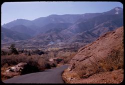
-
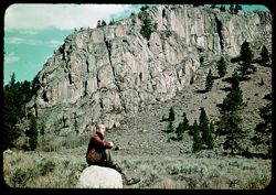
- Subject:
- Rocks, Men, Cliffs, Trees, Boulders, Mountains, Shrubs, and Hills
- Series:
- 7-38
- Creator:
- Cushman, Charles W., 1896-1972
- Date Created:
- 1938-10-01
- Genre:
- Landscape photographs and Portraits
- Frame Number:
- 3
- Street Address:
- Red Lodge Highway and Cooke-Red Lodge Highway
- County:
- Park and Carbon
- Persons Pictured:
- Cushman, Charles W. (Charles Weever), 1896-1972
- Abstract:
- G-3= Roadside scene along Cooke - Red Lodge Hwy.
- Call Number:
- P01513
- City:
- Cooke City and Red Lodge
- Country:
- United States
- State/Province:
- Montana
- Physical Description:
- Color corrected: magenta cast [fading of yellow dye].
- Alternate Identifier:
- 738.3
- Persistent URL:
- http://purl.dlib.indiana.edu/iudl/archives/cushman/P01513
- Holding Location:
- Bloomington - University Archives
Wells Library E460
1320 E 10th St.
Bloomington, IN 47405
Contact at archives@indiana.edu, 812-855-1127
-
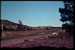
- Subject:
- San Francisco Peaks (Ariz.), Hills, Automobiles, Roads, Bridges, Mountains, Grand Canyon Junction (Ariz.), Shrubs, Snow, Trees, Rocks, Fences, and Masonry
- Series:
- 10-39
- Creator:
- Cushman, Charles W., 1896-1972
- Date Created:
- 1939-12-01
- Genre:
- Landscape photographs
- Frame Number:
- 3
- County:
- Coconino
- Abstract:
- T-3: San Franciscos Pk. from Grand Canyon Junction
- Call Number:
- P01719
- City:
- Flagstaff
- Country:
- United States
- State/Province:
- Arizona
- Physical Description:
- some dye fading. Image was originally mounted in a glass enclosure. Before digitization, the image was removed and placed in a Wess Plastic, Inc. brand, 2&qu...
- Alternate Identifier:
- 1039.3
- Persistent URL:
- http://purl.dlib.indiana.edu/iudl/archives/cushman/P01719
- Holding Location:
- Bloomington - University Archives
Wells Library E460
1320 E 10th St.
Bloomington, IN 47405
Contact at archives@indiana.edu, 812-855-1127
-
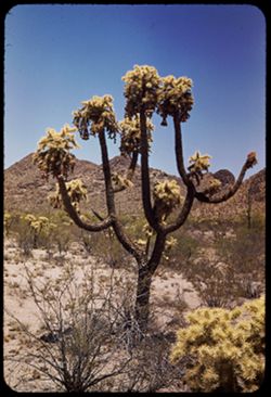
- Subject:
- Cactus, Flowers, Mountains, Shrubs, Tucson Mountains (Ariz.), and Cholla
- Series:
- 5-40
- Creator:
- Cushman, Charles W., 1896-1972
- Date Created:
- 1940-05-01
- Genre:
- Identification photographs
- Frame Number:
- 3
- County:
- Pima
- Abstract:
- Cursed cholla-in Tucson Mtn. Foothills
- Call Number:
- P01811
- Country:
- United States
- State/Province:
- Arizona
- Alternate Identifier:
- 540.3
- Persistent URL:
- http://purl.dlib.indiana.edu/iudl/archives/cushman/P01811
- Holding Location:
- Bloomington - University Archives
Wells Library E460
1320 E 10th St.
Bloomington, IN 47405
Contact at archives@indiana.edu, 812-855-1127
-
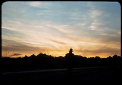
- Subject:
- Roads, Trees, Mountains, Tucson Mountains (Ariz.), Clouds, and Sunrises & sunsets
- Series:
- 2-40
- Creator:
- Cushman, Charles W., 1896-1972
- Date Created:
- 1940-02-01
- Genre:
- Landscape photographs
- Frame Number:
- 3
- Street Address:
- Ajo Way
- Abstract:
- Sunday evening , sunset sky, along Ajo road.
- Call Number:
- P01758
- Country:
- United States
- State/Province:
- Arizona
- Alternate Identifier:
- 240.3
- Persistent URL:
- http://purl.dlib.indiana.edu/iudl/archives/cushman/P01758
- Holding Location:
- Bloomington - University Archives
Wells Library E460
1320 E 10th St.
Bloomington, IN 47405
Contact at archives@indiana.edu, 812-855-1127
-
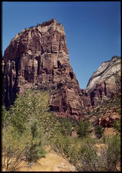
- Subject:
- Angels Landing (Utah), Cliffs, Trees, Virgin River, Mountains, Shrubs, Zion National Park (Utah), and National parks & reserves
- Series:
- 11-40
- Creator:
- Cushman, Charles W., 1896-1972
- Date Created:
- 1940-07-11
- Genre:
- Landscape photographs
- Frame Number:
- 3
- County:
- Washington
- Abstract:
- Angel's Landing. View is north from river bank.
- Call Number:
- P01963
- Country:
- United States
- State/Province:
- Utah
- Physical Description:
- Image was originally mounted in a glass enclosure. Before digitization, the image was removed and placed in a Wess Plastic, Inc. brand, 2" x 2", pl...
- Alternate Identifier:
- 1140.3
- Persistent URL:
- http://purl.dlib.indiana.edu/iudl/archives/cushman/P01963
- Holding Location:
- Bloomington - University Archives
Wells Library E460
1320 E 10th St.
Bloomington, IN 47405
Contact at archives@indiana.edu, 812-855-1127
-
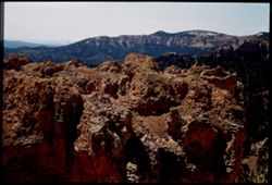
- Subject:
- Rocks, Canyons, Cliffs, Bryce Canyon National Park (Utah), Trees, Mountains, National parks & reserves, and Bryce Canyon (Utah : Valley)
- Series:
- 12-40
- Creator:
- Cushman, Charles W., 1896-1972
- Date Created:
- 1940-07-12
- Genre:
- Landscape photographs
- Frame Number:
- 3
- County:
- Garfield
- Abstract:
- Great clump of colored rock.
- Call Number:
- P01982
- Country:
- United States
- State/Province:
- Utah
- Physical Description:
- Image was originally mounted in a glass enclosure. Before digitization, the image was removed and placed in a Wess Plastic, Inc. brand, 2" x 2", pl...
- Alternate Identifier:
- 1240.3
- Persistent URL:
- http://purl.dlib.indiana.edu/iudl/archives/cushman/P01982
- Holding Location:
- Bloomington - University Archives
Wells Library E460
1320 E 10th St.
Bloomington, IN 47405
Contact at archives@indiana.edu, 812-855-1127
-
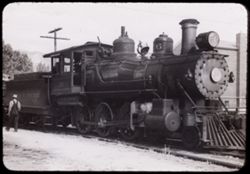
- Subject:
- Railroad locomotives, Trees, Mountains, Bells, Facilities, Virginia and Truckee Railroad, Utility poles, and Railroad employees
- Series:
- 23-40
- Creator:
- Cushman, Charles W., 1896-1972
- Date Created:
- 1940-07-07
- Frame Number:
- 3
- County:
- Carson City
- Abstract:
- 40-J-3=at Carson City, Nev.-Virginia & Truckee RR
- Call Number:
- P01950
- City:
- Carson City
- Country:
- United States
- State/Province:
- Nevada
- Physical Description:
- black & white .
- Alternate Identifier:
- 2340.3
- Persistent URL:
- http://purl.dlib.indiana.edu/iudl/archives/cushman/P01950
- Holding Location:
- Bloomington - University Archives
Wells Library E460
1320 E 10th St.
Bloomington, IN 47405
Contact at archives@indiana.edu, 812-855-1127
-
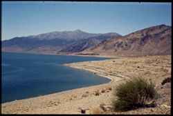
- Subject:
- Walker Lake, Mountains, Shrubs, Lakes & ponds, and Coastlines
- Series:
- 10-40
- Creator:
- Cushman, Charles W., 1896-1972
- Date Created:
- 1940-07-09
- Genre:
- Landscape photographs
- Frame Number:
- 3
- County:
- Mineral
- Call Number:
- P01925
- Country:
- United States
- State/Province:
- Nevada
- Physical Description:
- Image was originally mounted in a glass enclosure. Before digitization, the image was removed and placed in a Wess Plastic, Inc. brand, 2" x 2", pl...
- Alternate Identifier:
- 1040.3
- Persistent URL:
- http://purl.dlib.indiana.edu/iudl/archives/cushman/P01925
- Holding Location:
- Bloomington - University Archives
Wells Library E460
1320 E 10th St.
Bloomington, IN 47405
Contact at archives@indiana.edu, 812-855-1127
-
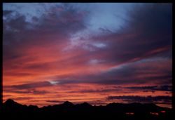
- Subject:
- Mountains, Clouds, and Sunrises & sunsets
- Series:
- 3-40
- Creator:
- Cushman, Charles W., 1896-1972
- Date Created:
- 1940-03-01
- Genre:
- Landscape photographs
- Frame Number:
- 3
- County:
- Pima
- Abstract:
- Northwestern sky after sunset
- Call Number:
- P01775
- City:
- Tucson
- Country:
- United States
- State/Province:
- Arizona
- Physical Description:
- Image was originally mounted in a glass enclosure. Before digitization, the image was removed and placed in a Wess Plastic, Inc. brand, 2" x 2", pl...
- Alternate Identifier:
- 340.3
- Persistent URL:
- http://purl.dlib.indiana.edu/iudl/archives/cushman/P01775
- Holding Location:
- Bloomington - University Archives
Wells Library E460
1320 E 10th St.
Bloomington, IN 47405
Contact at archives@indiana.edu, 812-855-1127
-
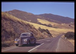
- Subject:
- Roads, Automobiles, Trees, Mountains, Fences, and Shrubs
- Series:
- 7-40
- Creator:
- Cushman, Charles W., 1896-1972
- Date Created:
- 1940-06-20
- Genre:
- Landscape photographs
- Frame Number:
- 3
- Street Address:
- Atascadero Road
- County:
- San Luis Obispo
- Abstract:
- The Morro Bay- Atascadero road.
- Call Number:
- P01859
- City:
- Morro Bay
- Country:
- United States
- State/Province:
- California
- Physical Description:
- Image was originally mounted in a glass enclosure. Before digitization, the image was removed and placed in a Wess Plastic, Inc. brand, 2" x 2", pl...
- Alternate Identifier:
- 740.3
- Persistent URL:
- http://purl.dlib.indiana.edu/iudl/archives/cushman/P01859
- Holding Location:
- Bloomington - University Archives
Wells Library E460
1320 E 10th St.
Bloomington, IN 47405
Contact at archives@indiana.edu, 812-855-1127
-
- Subject:
- Mountains, Buildings, Santa Rita Mountains (Ariz.), Sunrises & sunsets, and Cities & towns
- Series:
- 1-40
- Creator:
- Cushman, Charles W., 1896-1972
- Date Created:
- 1940-01-01
- Genre:
- Landscape photographs and Snapshots
- Frame Number:
- 3
- County:
- Pima
- Abstract:
- Southern sky over Santa Ritas at sunset
- Call Number:
- P01740
- City:
- Tucson
- Country:
- United States
- State/Province:
- Arizona
- Physical Description:
- Image was originally mounted in a glass enclosure. Before digitization, the image was removed and placed in a Wess Plastic, Inc. brand, 2" x 2", pl...
- Alternate Identifier:
- 140.3
- Persistent URL:
- http://purl.dlib.indiana.edu/iudl/archives/cushman/P01740
- Holding Location:
- Bloomington - University Archives
Wells Library E460
1320 E 10th St.
Bloomington, IN 47405
Contact at archives@indiana.edu, 812-855-1127
-
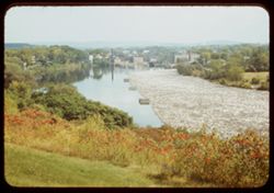
- Subject:
- Reflections, Kennebec River (Me.), Mountains, and Rivers
- Series:
- 17-41
- Creator:
- Cushman, Charles W., 1896-1972
- Date Created:
- 1941-09-16
- Genre:
- Cityscape photographs
- Frame Number:
- 3
- County:
- Somerset
- Abstract:
- Looking down on Skowhegan and log jam in Androscogin
- Call Number:
- P02445
- City:
- Skowhegan
- Country:
- United States
- State/Province:
- Maine
- Alternate Identifier:
- 1741.3
- Persistent URL:
- http://purl.dlib.indiana.edu/iudl/archives/cushman/P02445
- Holding Location:
- Bloomington - University Archives
Wells Library E460
1320 E 10th St.
Bloomington, IN 47405
Contact at archives@indiana.edu, 812-855-1127
-
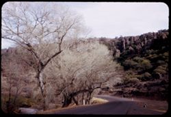
- Description:
- 25 f 8
- Subject:
- Cliffs, Trees, Mountains, Rock formations, Cottonwood, Hills, Streams, and Roads
- Series:
- 17-51
- Creator:
- Cushman, Charles W., 1896-1972
- Date Created:
- 1951-12-29
- Genre:
- Landscape photographs and Identification photographs
- Frame Number:
- 3
- Street Address:
- Texas State Highway 118
- County:
- Jeff Davis
- Abstract:
- Cottonwoods along Hwy 118 north of Ft. Davis.
- Call Number:
- P05460
- City:
- Fort Davis
- Country:
- United States
- State/Province:
- Texas
- Alternate Identifier:
- 1751.3
- Persistent URL:
- http://purl.dlib.indiana.edu/iudl/archives/cushman/P05460
- Holding Location:
- Bloomington - University Archives
Wells Library E460
1320 E 10th St.
Bloomington, IN 47405
Contact at archives@indiana.edu, 812-855-1127
-
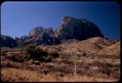
- Description:
- 25 f 6.3 Pola
- Subject:
- National parks & reserves, Hills, Cliffs, Big Bend National Park (Tex.), Mountains, Shrubs, Cactus, Trees, and Grasses
- Series:
- 16-51
- Creator:
- Cushman, Charles W., 1896-1972
- Date Created:
- 1951-12-27
- Genre:
- Landscape photographs
- Frame Number:
- 3
- County:
- Brewster
- Abstract:
- In Big Bend Pk.
- Call Number:
- P05422
- Country:
- United States
- State/Province:
- Texas
- Alternate Identifier:
- 1651.3
- Persistent URL:
- http://purl.dlib.indiana.edu/iudl/archives/cushman/P05422
- Holding Location:
- Bloomington - University Archives
Wells Library E460
1320 E 10th St.
Bloomington, IN 47405
Contact at archives@indiana.edu, 812-855-1127
-
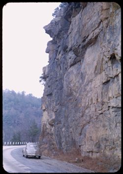
- Description:
- 25 f 4.5
- Subject:
- Roads, Automobiles, Signal Mountain (Tenn.), Mountains, and Cliffs
- Series:
- 8-51
- Creator:
- Cushman, Charles W., 1896-1972
- Date Created:
- 1951-12-02
- Genre:
- Landscape photographs
- Frame Number:
- 3
- County:
- Hamilton
- Abstract:
- Up Signal Mtn. Near Chattanooga
- Call Number:
- P05108
- City:
- Chattanooga
- Country:
- United States
- State/Province:
- Tennessee
- Alternate Identifier:
- 851.3
- Persistent URL:
- http://purl.dlib.indiana.edu/iudl/archives/cushman/P05108
- Holding Location:
- Bloomington - University Archives
Wells Library E460
1320 E 10th St.
Bloomington, IN 47405
Contact at archives@indiana.edu, 812-855-1127
-
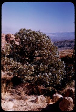
- Description:
- 25 f 9
- Subject:
- National parks & reserves, Berries, Colorado National Monument (Colo.), Cliffs, Mountains, Shrubs, Boulders, Rocks, Junipers, and Trees
- Series:
- 26-52
- Creator:
- Cushman, Charles W., 1896-1972
- Date Created:
- 1952-11-03
- Genre:
- Identification photographs
- Frame Number:
- 3
- County:
- Mesa
- Abstract:
- Juniper. A beauty.
- Call Number:
- P06410
- City:
- Grand Junction
- Country:
- United States
- State/Province:
- Colorado
- Alternate Identifier:
- 2652.3
- Persistent URL:
- http://purl.dlib.indiana.edu/iudl/archives/cushman/P06410
- Holding Location:
- Bloomington - University Archives
Wells Library E460
1320 E 10th St.
Bloomington, IN 47405
Contact at archives@indiana.edu, 812-855-1127
-
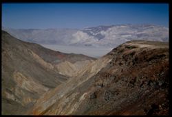
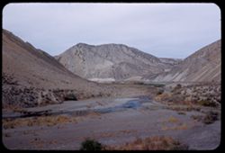
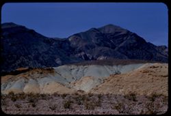
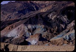
- Description:
- 25 f 9
- Subject:
- Panamint Mountains (Calif.), Deserts, Canyons, Valleys, Death Valley (Calif. and Nev.), Panamint Valley (Calif.), Mountains, Cliffs, and Panamint Range (Calif.)
- Series:
- 15-52
- Creator:
- Cushman, Charles W., 1896-1972
- Date Created:
- 1952-04-01
- Genre:
- Landscape photographs
- Frame Number:
- 3
- County:
- Inyo
- Abstract:
- Mouth of Canyon into Panamint Valley - Panamint Mtns in distance.
- Call Number:
- P06024
- Country:
- United States
- State/Province:
- California
- Physical Description:
- Image was originally mounted in a glass enclosure. Before digitization, the image was removed and placed in a Wess Plastic, Inc. brand, 2" x 2", pl...
- Alternate Identifier:
- 1552.3
- Persistent URL:
- http://purl.dlib.indiana.edu/iudl/archives/cushman/P06024
- Holding Location:
- Bloomington - University Archives
Wells Library E460
1320 E 10th St.
Bloomington, IN 47405
Contact at archives@indiana.edu, 812-855-1127
-
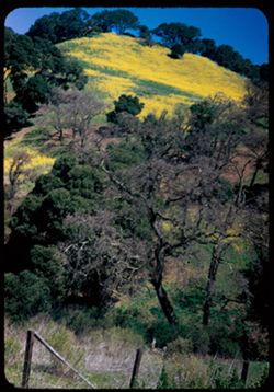
- Description:
- 25 f 9
- Subject:
- Wildflowers, Trees, Flowers, Mountains, Fences, Hills, and Mustard (Plant)
- Series:
- 10-52
- Creator:
- Cushman, Charles W., 1896-1972
- Date Created:
- 1952-03-09
- Genre:
- Landscape photographs
- Frame Number:
- 3
- Street Address:
- California State Highway 24
- County:
- Alameda and Contra Costa
- Abstract:
- Mustard covered mtn. Side nr. Lafayette on Cal 24
- Call Number:
- P05839
- City:
- Oakland and Lafayette
- Country:
- United States
- State/Province:
- California
- Alternate Identifier:
- 1052.3
- Persistent URL:
- http://purl.dlib.indiana.edu/iudl/archives/cushman/P05839
- Holding Location:
- Bloomington - University Archives
Wells Library E460
1320 E 10th St.
Bloomington, IN 47405
Contact at archives@indiana.edu, 812-855-1127
-
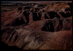
- Description:
- 50 f 6.3 Pola
- Subject:
- Deserts, Hills, Cliffs, Mountains, Mesas, and Painted Desert (Ariz.)
- Series:
- 17-52
- Creator:
- Cushman, Charles W., 1896-1972
- Date Created:
- 1952-04-12
- Genre:
- Landscape photographs
- Frame Number:
- 3
- County:
- Navajo and Coconimo
- Call Number:
- P06097
- City:
- Holbrook
- Country:
- United States
- State/Province:
- Arizona
- Physical Description:
- Image was originally mounted in a glass enclosure. Before digitization, the image was removed and placed in a Wess Plastic, Inc. brand, 2" x 2", pl...
- Alternate Identifier:
- 1752.3
- Persistent URL:
- http://purl.dlib.indiana.edu/iudl/archives/cushman/P06097
- Holding Location:
- Bloomington - University Archives
Wells Library E460
1320 E 10th St.
Bloomington, IN 47405
Contact at archives@indiana.edu, 812-855-1127
-
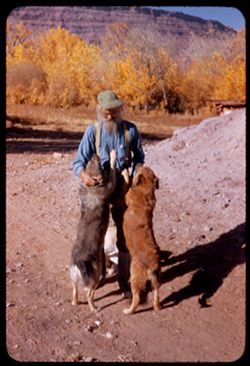
- Description:
- 1/50 f 6.3 or f 5.6
- Subject:
- Dogs, Men, Hills, Mountains, Dirt roads, Families, Shadows, and Trees
- Series:
- 27-52
- Creator:
- Cushman, Charles W., 1896-1972
- Date Created:
- 1952-11-04
- Genre:
- Portraits
- Frame Number:
- 3
- County:
- Grand
- Persons Pictured:
- Holley, Jack W.
- Abstract:
- 1 to 7 - at Jack Holley's abode
- Call Number:
- P06448
- City:
- Moab
- Country:
- United States
- State/Province:
- Utah
- Alternate Identifier:
- 2752.3
- Persistent URL:
- http://purl.dlib.indiana.edu/iudl/archives/cushman/P06448
- Holding Location:
- Bloomington - University Archives
Wells Library E460
1320 E 10th St.
Bloomington, IN 47405
Contact at archives@indiana.edu, 812-855-1127
-
- Description:
- 25 f 11
- Subject:
- Trees, Signs (Notices), Mountains, Shrubs, Hills, and Garden of the Gods (Colorado Springs, Colo.)
- Series:
- 22-52
- Creator:
- Cushman, Charles W., 1896-1972
- Date Created:
- 1952-10-27
- Genre:
- Landscape photographs and Cityscape photographs
- Frame Number:
- 3
- County:
- El Paso
- Abstract:
- View south from G of G over Manitou Spgs
- Call Number:
- P06257
- City:
- Manitou Springs
- Country:
- United States
- State/Province:
- Colorado
- Alternate Identifier:
- 2252.3
- Persistent URL:
- http://purl.dlib.indiana.edu/iudl/archives/cushman/P06257
- Holding Location:
- Bloomington - University Archives
Wells Library E460
1320 E 10th St.
Bloomington, IN 47405
Contact at archives@indiana.edu, 812-855-1127
-
![View northward up Apache Trail [Ariz 88] from US 60-70 near Miami, Ariz.](https://iiif.uits.iu.edu/iiif/2/4t64gn68z%2Ffiles%2F8b7f1c67-b13e-4a94-a15c-638f142e49ee/full/250,/0/default.jpg)
- Description:
- 50 f 5.6 POLA
- Subject:
- Grasses, Trails & paths, Trees, Mountains, and Hills
- Series:
- 14-53
- Creator:
- Cushman, Charles W., 1896-1972
- Date Created:
- 1953-11-19
- Genre:
- Landscape photographs
- Frame Number:
- 3
- Street Address:
- United States Highway 60 and United States Highway 70
- County:
- Gila
- Abstract:
- View up Apache Trail
- Call Number:
- P06999
- City:
- Miami
- Country:
- United States
- State/Province:
- Arizona
- Alternate Identifier:
- 1453.3
- Persistent URL:
- http://purl.dlib.indiana.edu/iudl/archives/cushman/P06999
- Holding Location:
- Bloomington - University Archives
Wells Library E460
1320 E 10th St.
Bloomington, IN 47405
Contact at archives@indiana.edu, 812-855-1127
-
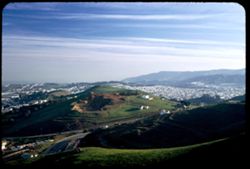
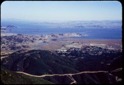
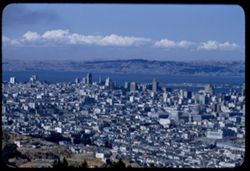
- Description:
- 25 f 4.5 Pola
- Subject:
- San Bruno Mountain (Calif.), Twin Peaks (San Francisco County, Calif.), Automobiles, Trees, Shadows, Mountains, Buildings, Clouds, Dwellings, Hills, and Roads
- Series:
- 2-53
- Creator:
- Cushman, Charles W., 1896-1972
- Date Created:
- 1953-01-22
- Genre:
- Cityscape photographs
- Frame Number:
- 3
- County:
- San Francisco
- Abstract:
- South from Twin Peaks at 3:45.
- Call Number:
- P06537
- City:
- San Francisco
- Country:
- United States
- State/Province:
- California
- Alternate Identifier:
- 253.3
- Persistent URL:
- http://purl.dlib.indiana.edu/iudl/archives/cushman/P06537
- Holding Location:
- Bloomington - University Archives
Wells Library E460
1320 E 10th St.
Bloomington, IN 47405
Contact at archives@indiana.edu, 812-855-1127
-
- Description:
- 50 f 9+
- Subject:
- Canyons, Grasses, Roads, Dirt, Humboldt River (Nev.), Mountains, Shrubs, Humboldt River Valley (Nev.), Rivers, and Valleys
- Series:
- 9-53
- Creator:
- Cushman, Charles W., 1896-1972
- Date Created:
- 1953-10-10
- Genre:
- Landscape photographs
- Frame Number:
- 3
- Street Address:
- United States Highway 40
- County:
- Elko
- Abstract:
- Another angle of Humboldt river gorge about 20 mi. west of Elko
- Call Number:
- P06804
- City:
- Elko
- Country:
- United States
- State/Province:
- Nevada
- Alternate Identifier:
- 953.3
- Persistent URL:
- http://purl.dlib.indiana.edu/iudl/archives/cushman/P06804
- Holding Location:
- Bloomington - University Archives
Wells Library E460
1320 E 10th St.
Bloomington, IN 47405
Contact at archives@indiana.edu, 812-855-1127
-
- Description:
- 50 f 6.3
- Subject:
- Snow, Roads, Trees, Mountains, and Cliffs
- Series:
- 15-53
- Creator:
- Cushman, Charles W., 1896-1972
- Date Created:
- 1953-11-20
- Genre:
- Landscape photographs
- Frame Number:
- 3
- County:
- Yavapai
- Abstract:
- Snow covered cliffs along US 89 about 7 miles sw of Prescott
- Call Number:
- P07037
- City:
- Prescott
- Country:
- United States
- State/Province:
- Arizona
- Alternate Identifier:
- 1553.3
- Persistent URL:
- http://purl.dlib.indiana.edu/iudl/archives/cushman/P07037
- Holding Location:
- Bloomington - University Archives
Wells Library E460
1320 E 10th St.
Bloomington, IN 47405
Contact at archives@indiana.edu, 812-855-1127
-
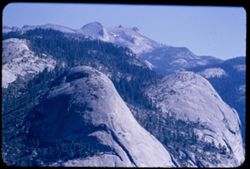
- Description:
- 50 f 6.3
- Subject:
- Yosemite Valley (Calif.), Valleys, Yosemite National Park (Calif.), Mirror Lake (Mariposa County, Calif.), Half Dome (Calif.), Mountains, National parks &...
- Series:
- 6-53
- Creator:
- Cushman, Charles W., 1896-1972
- Date Created:
- 1953-05-14
- Genre:
- Landscape photographs
- Frame Number:
- 3
- County:
- Mariposa
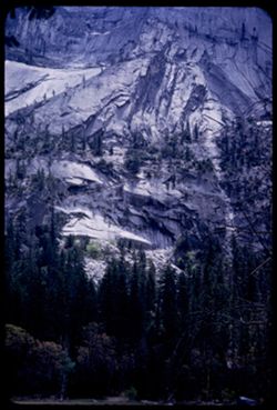
- Abstract:
- Rock face below Half Dome from Mirror Lake
- Call Number:
- P06691
- Country:
- United States
- State/Province:
- California
- Alternate Identifier:
- 653.3
- Persistent URL:
- http://purl.dlib.indiana.edu/iudl/archives/cushman/P06691
- Holding Location:
- Bloomington - University Archives
Wells Library E460
1320 E 10th St.
Bloomington, IN 47405
Contact at archives@indiana.edu, 812-855-1127
-
- Description:
- 50 f 6.3 Pola
- Subject:
- La Plata Mountains (Colo.), Reservoirs, Shadows, Mountains, Beaches, Lakes & ponds, Clouds, Waterfronts, Elbert, Mount (Colo.), Grasses, Grizzly Peak (Co...
- Series:
- 11-53
- Creator:
- Cushman, Charles W., 1896-1972
- Date Created:
- 1953-10-15
- Genre:
- Landscape photographs
- Frame Number:
- 3
- County:
- Elbert and Lake
- Abstract:
- Mountain south of Elbert
- Call Number:
- P06882
- City:
- Elbert and Leadville
- Country:
- United States
- State/Province:
- Colorado
- Alternate Identifier:
- 1153.3
- Persistent URL:
- http://purl.dlib.indiana.edu/iudl/archives/cushman/P06882
- Holding Location:
- Bloomington - University Archives
Wells Library E460
1320 E 10th St.
Bloomington, IN 47405
Contact at archives@indiana.edu, 812-855-1127
-
- Description:
- 50 f 8
- Subject:
- Cascade Range, Roads, Trees, Pines, Volcanoes, Volcanic domes, Lassen Volcanic National Park (Calif.), Lava domes, Clouds, Mountains, and Lassen Peak (Calif.)
- Series:
- 6-54
- Creator:
- Cushman, Charles W., 1896-1972
- Date Created:
- 1954-08-19
- Genre:
- Landscape photographs
- Frame Number:
- 3
- County:
- Shasta
- Abstract:
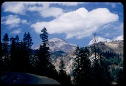
- Mt. Lassen
- Call Number:
- P07222
- Country:
- United States
- State/Province:
- California
- Alternate Identifier:
- 654.3
- Persistent URL:
- http://purl.dlib.indiana.edu/iudl/archives/cushman/P07222
- Holding Location:
- Bloomington - University Archives
Wells Library E460
1320 E 10th St.
Bloomington, IN 47405
Contact at archives@indiana.edu, 812-855-1127
-
- Description:
- 50 f 9
- Subject:
- Snow, Automobiles, Trees, Volcanoes, Volcanic domes, Lassen Volcanic National Park (Calif.), Lava domes, Shrubs, Lassen Peak (Calif.), and Mountains
- Series:
- 5-54
- Creator:
- Cushman, Charles W., 1896-1972
- Date Created:
- 1954-08-19
- Genre:
- Landscape photographs
- Frame Number:
- 3
- County:
- Shasta
- Abstract:
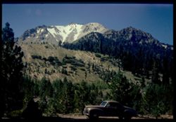
- East face of Lassen Pk with snow valleys (car in foreground) Cushman
- Call Number:
- P07199
- Country:
- United States
- State/Province:
- California
- Physical Description:
- Image was originally mounted in a glass enclosure. Before digitization, the image was removed and placed in a Wess Plastic, Inc. brand, 2" x 2", pl...
- Alternate Identifier:
- 554.3
- Persistent URL:
- http://purl.dlib.indiana.edu/iudl/archives/cushman/P07199
- Holding Location:
- Bloomington - University Archives
Wells Library E460
1320 E 10th St.
Bloomington, IN 47405
Contact at archives@indiana.edu, 812-855-1127
-
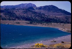
- Description:
- 50 f 6.3
- Subject:
- Bodies of water, Trees, Coastlines, June Lake (Calif.), Shrubs, Lakes & ponds, Flowers, and Mountains
- Series:
- 11-54
- Creator:
- Cushman, Charles W., 1896-1972
- Date Created:
- 1954-09-16
- Genre:
- Landscape photographs
- Frame Number:
- 3
- County:
- Mono
- Abstract:
- June Lake from east side in mid afternoon.
- Call Number:
- P07372
- Country:
- United States
- State/Province:
- California
- Alternate Identifier:
- 1154.3
- Persistent URL:
- http://purl.dlib.indiana.edu/iudl/archives/cushman/P07372
- Holding Location:
- Bloomington - University Archives
Wells Library E460
1320 E 10th St.
Bloomington, IN 47405
Contact at archives@indiana.edu, 812-855-1127
-
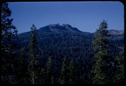
Dardanelles Cone above Stanislaus river canyon a few miles west of Dardanelle - from Calif. Hwy 108.
- Description:
- 50 f 8
- Subject:
- Dardanelles Butte (Calif.), Canyons, Lava flows, Mountains, Trees, Stanislaus River (Calif.), Buttes, Volcanoes, and Dardanelles Cone (Calif.)
- Series:
- 9-54
- Creator:
- Cushman, Charles W., 1896-1972
- Date Created:
- 1954-09-15
- Genre:
- Landscape photographs
- Frame Number:
- 3
- Street Address:
- California State Highway 108
- County:
- Tuolumne
- Abstract:
- Dardanelles Cone. Looking north across canyon from Hwy 108 about 8 or 9 miles w. of Dardanelle.
- Call Number:
- P07314
- City:
- Dardanelle
- Country:
- United States
- State/Province:
- California
- Alternate Identifier:
- 954.3
- Persistent URL:
- http://purl.dlib.indiana.edu/iudl/archives/cushman/P07314
- Holding Location:
- Bloomington - University Archives
Wells Library E460
1320 E 10th St.
Bloomington, IN 47405
Contact at archives@indiana.edu, 812-855-1127
-
- Description:
- 50 f 9
- Subject:
- San Quentin Bridge (Calif.), Bodies of water, Trees, Cities & towns, Buildings, Shrubs, Tamalpais, Mount (Calif.), Hills, and Mountains
- Series:
- 16-54
- Creator:
- Cushman, Charles W., 1896-1972
- Date Created:
- 1954-10-23
- Genre:
- Landscape photographs
- Frame Number:
- 3
- County:
- Marin
- Abstract:
- View east from Tamalpais down toward San Quentin + [?] bridge.
- Call Number:
- P07502
- Country:
- United States
- State/Province:
- California
- Physical Description:
- Anscochrome film.
- Alternate Identifier:
- 1654.3
- Persistent URL:
- http://purl.dlib.indiana.edu/iudl/archives/cushman/P07502
- Holding Location:
- Bloomington - University Archives
Wells Library E460
1320 E 10th St.
Bloomington, IN 47405
Contact at archives@indiana.edu, 812-855-1127
-
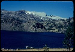
- Description:
- 50 f 9
- Subject:
- Bodies of water, Yosemite National Park (Calif.), Boats, Tioga Pass (Calif.), Mountains, Shrubs, Lakes & ponds, Passes (Landforms), Ellery Lake (Calif.),...
- Series:
- 10-54
- Creator:
- Cushman, Charles W., 1896-1972
- Date Created:
- 1954-09-16
- Genre:
- Landscape photographs
- Frame Number:
- 3
- County:
- Mono
- Abstract:
- Ellory [sic] Lake.
- Call Number:
- P07350
- Country:
- United States
- State/Province:
- California
- Physical Description:
- Anscochrome film.
- Alternate Identifier:
- 1054.3
- Persistent URL:
- http://purl.dlib.indiana.edu/iudl/archives/cushman/P07350
- Holding Location:
- Bloomington - University Archives
Wells Library E460
1320 E 10th St.
Bloomington, IN 47405
Contact at archives@indiana.edu, 812-855-1127
-
- Description:
- 100 f 5.6 tl
- Subject:
- Mountains, Trees, and Shrubs
- Series:
- 17-55
- Creator:
- Cushman, Charles W., 1896-1972
- Date Created:
- 1955-06-16
- Frame Number:
- 3
- County:
- Trinity and Shasta
- Abstract:
- Tree dotted mtn slope in Shasta County [65568 mi]
- Call Number:
- P08085
- City:
- Weaverville
- Country:
- United States
- State/Province:
- California
- Alternate Identifier:
- 1755.3
- Persistent URL:
- http://purl.dlib.indiana.edu/iudl/archives/cushman/P08085
- Holding Location:
- Bloomington - University Archives
Wells Library E460
1320 E 10th St.
Bloomington, IN 47405
Contact at archives@indiana.edu, 812-855-1127
-
- Description:
- 50 mm lens
- Subject:
- Valleys, Dantes View (Calif.), Mountains, Death Valley (Calif. and Nev.), Black Mountains (Inyo County, Calif.), and Clouds
- Series:
- 3-55
- Creator:
- Cushman, Charles W., 1896-1972
- Date Created:
- 1955-02-27
- Genre:
- Landscape photographs
- Frame Number:
- 3
- County:
- Inyo
- Abstract:
- View north along ridge of Black Mtns
- Call Number:
- P07596
- Country:
- United States
- State/Province:
- California
- Alternate Identifier:
- 355.3
- Persistent URL:
- http://purl.dlib.indiana.edu/iudl/archives/cushman/P07596
- Holding Location:
- Bloomington - University Archives
Wells Library E460
1320 E 10th St.
Bloomington, IN 47405
Contact at archives@indiana.edu, 812-855-1127
-
- Description:
- 100 f 6.3 tl
- Subject:
- Valleys, Death Valley (Calif. and Nev.), Mountains, and Tucki Mountain (Calif.)
- Series:
- 8-55
- Creator:
- Cushman, Charles W., 1896-1972
- Date Created:
- 1955-03-21
- Genre:
- Landscape photographs
- Frame Number:
- 3
- Street Address:
- California State Highway 190
- County:
- Inyo
- Abstract:
- South toward Tucki Mtn from near Stovepipe Wells
- Call Number:
- P07764
- City:
- Stovepipe Wells
- Country:
- United States
- State/Province:
- California
- Alternate Identifier:
- 855.3
- Persistent URL:
- http://purl.dlib.indiana.edu/iudl/archives/cushman/P07764
- Holding Location:
- Bloomington - University Archives
Wells Library E460
1320 E 10th St.
Bloomington, IN 47405
Contact at archives@indiana.edu, 812-855-1127
-
- Description:
- 100 f 5 tl
- Subject:
- Hills, Roads, Mountains, Trees, Buildings, Clouds, and Greenhorn Mountains (Calif.)
- Series:
- 2-55
- Creator:
- Cushman, Charles W., 1896-1972
- Date Created:
- 1955-02-26
- Genre:
- Landscape photographs
- Frame Number:
- 3
- Street Address:
- California State Highway 178
- County:
- Kern
- Abstract:
- From pt. 12 mi E of Bakersfield view east toward Greenhorn Mtns
- Call Number:
- P07561
- City:
- Bakersfield
- Country:
- United States
- State/Province:
- California
- Alternate Identifier:
- 255.3
- Persistent URL:
- http://purl.dlib.indiana.edu/iudl/archives/cushman/P07561
- Holding Location:
- Bloomington - University Archives
Wells Library E460
1320 E 10th St.
Bloomington, IN 47405
Contact at archives@indiana.edu, 812-855-1127
-
- Description:
- 100 f 8 tl
- Subject:
- Valleys, Buttes, Mountains, Shrubs, Death Valley National Park (Calif. and Nev.), and Black Mountains (Inyo County, Calif.)
- Series:
- 9-55
- Creator:
- Cushman, Charles W., 1896-1972
- Date Created:
- 1955-03-22
- Genre:
- Landscape photographs
- Frame Number:
- 3
- County:
- Inyo
- Abstract:
- Green & brown butte below east side of Black Mtns
- Call Number:
- P07795
- Country:
- United States
- State/Province:
- California
- Alternate Identifier:
- 955.3
- Persistent URL:
- http://purl.dlib.indiana.edu/iudl/archives/cushman/P07795
- Holding Location:
- Bloomington - University Archives
Wells Library E460
1320 E 10th St.
Bloomington, IN 47405
Contact at archives@indiana.edu, 812-855-1127
-
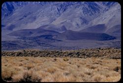
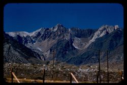
- Description:
- 100 f 6.3
- Subject:
- Rocks, Grasses, Mountains, Sierra Nevada (Calif. and Nev.), and Hills
- Series:
- 26-55
- Creator:
- Cushman, Charles W., 1896-1972
- Date Created:
- 1955-09-25
- Genre:
- Landscape photographs
- Frame Number:
- 3
- County:
- Inyo
- Abstract:
- Looking at base of range to SSW
- Call Number:
- P08386
- City:
- Big Pine and Independence
- Country:
- United States
- State/Province:
- California
- Alternate Identifier:
- 2655.3
- Persistent URL:
- http://purl.dlib.indiana.edu/iudl/archives/cushman/P08386
- Holding Location:
- Bloomington - University Archives
Wells Library E460
1320 E 10th St.
Bloomington, IN 47405
Contact at archives@indiana.edu, 812-855-1127
-
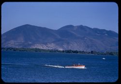
- Description:
- 100 f 5.6 TL
- Subject:
- Trees, Konocti, Mount (Calif.), Mountains, Lakes & ponds, Clear Lake (Lake County, Calif.), and Boats
- Series:
- 24-55
- Creator:
- Cushman, Charles W., 1896-1972
- Date Created:
- 1955-08-10
- Genre:
- Landscape photographs
- Frame Number:
- 3
- County:
- Lake
- Abstract:
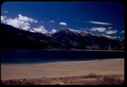
- Mt. Konocti across Clear Lake from Lake port
- Call Number:
- P08312
- City:
- Lakeport
- Country:
- United States
- State/Province:
- California
- Alternate Identifier:
- 2455.3
- Persistent URL:
- http://purl.dlib.indiana.edu/iudl/archives/cushman/P08312
- Holding Location:
- Bloomington - University Archives
Wells Library E460
1320 E 10th St.
Bloomington, IN 47405
Contact at archives@indiana.edu, 812-855-1127
-
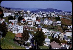
- Description:
- 200 f 4 tl
- Subject:
- Valleys, Trees, Diamond Heights (San Francisco, Calif.), Streets, Mountains, Fences, Dwellings, Hills, Utility poles, Buildings, and Lawns
- Series:
- 6-55
- Creator:
- Cushman, Charles W., 1896-1972
- Date Created:
- 1955-03-14
- Genre:
- Cityscape photographs
- Frame Number:
- 3
- Street Address:
- Farnum Street
- County:
- San Francisco
- Abstract:
- View north from top of Farnum St. on Diamond Heights Three in one views from Diamond Hts - near top of Farnum St. all in high wind
- Call Number:
- P07705
- City:
- San Francisco
- Country:
- United States
- State/Province:
- California
- Alternate Identifier:
- 655.3
- Persistent URL:
- http://purl.dlib.indiana.edu/iudl/archives/cushman/P07705
- Holding Location:
- Bloomington - University Archives
Wells Library E460
1320 E 10th St.
Bloomington, IN 47405
Contact at archives@indiana.edu, 812-855-1127
-
- Description:
- 100 f 6.3 tl
- Subject:
- Valleys, Mountains, Death Valley National Park (Calif. and Nev.), Hills, and Artists Palette (Calif.)
- Series:
- 10-55
- Creator:
- Cushman, Charles W., 1896-1972
- Date Created:
- 1955-03-22
- Genre:
- Landscape photographs
- Frame Number:
- 3
- County:
- Inyo
- Abstract:
- The artists Palette
- Call Number:
- P07831
- Country:
- United States
- State/Province:
- California
- Alternate Identifier:
- 1055.3
- Persistent URL:
- http://purl.dlib.indiana.edu/iudl/archives/cushman/P07831
- Holding Location:
- Bloomington - University Archives
Wells Library E460
1320 E 10th St.
Bloomington, IN 47405
Contact at archives@indiana.edu, 812-855-1127
-
- Description:
- 100 f 6.3 tl
- Subject:
- Bodies of water, Trees, Streets, Telegraph Hill (San Francisco, Calif.), Buildings, Clouds, Dwellings, Hills, Mountains, and Domes
- Series:
- 19-55
- Creator:
- Cushman, Charles W., 1896-1972
- Date Created:
- 1955-07-02
- Genre:
- Cityscape photographs
- Frame Number:
- 3
- County:
- San Francisco
- Abstract:
- Toward Telegraph Hill
- Call Number:
- P08156
- City:
- San Francisco
- Country:
- United States
- State/Province:
- California
- Alternate Identifier:
- 1955.3
- Persistent URL:
- http://purl.dlib.indiana.edu/iudl/archives/cushman/P08156
- Holding Location:
- Bloomington - University Archives
Wells Library E460
1320 E 10th St.
Bloomington, IN 47405
Contact at archives@indiana.edu, 812-855-1127
-
- Description:
- 100 f 8 tl
- Subject:
- Rocks, Mountains, Fences, Lake Crowley (Calif.), Sierra Nevada (Calif. and Nev.), and Utility poles
- Series:
- 27-55
- Creator:
- Cushman, Charles W., 1896-1972
- Date Created:
- 1955-09-26
- Genre:
- Landscape photographs
- Frame Number:
- 3
- County:
- Mono
- Abstract:
- Red & gray [jagged] peak west of Crowley Lake
- Call Number:
- P08423
- Country:
- United States
- State/Province:
- California
- Alternate Identifier:
- 2755.3
- Persistent URL:
- http://purl.dlib.indiana.edu/iudl/archives/cushman/P08423
- Holding Location:
- Bloomington - University Archives
Wells Library E460
1320 E 10th St.
Bloomington, IN 47405
Contact at archives@indiana.edu, 812-855-1127
-
- Description:
- 100 f 6 tl
- Subject:
- Valleys, Roads, Trees, Mountains, Buildings, Clouds, Tamalpais, Mount (Calif.), Hills, Utility poles, Fences, and Dwellings
- Series:
- 5-55
- Creator:
- Cushman, Charles W., 1896-1972
- Date Created:
- 1955-03-10
- Genre:
- Landscape photographs
- Frame Number:
- 3
- County:
- Marin
- Abstract:
- Cloud mass above Mt. Tamalpais from top of Sausalito
- Call Number:
- P07668
- City:
- Sausalito
- Country:
- United States
- State/Province:
- California
- Alternate Identifier:
- 555.3
- Persistent URL:
- http://purl.dlib.indiana.edu/iudl/archives/cushman/P07668
- Holding Location:
- Bloomington - University Archives
Wells Library E460
1320 E 10th St.
Bloomington, IN 47405
Contact at archives@indiana.edu, 812-855-1127
-
- Description:
- 100 f 5.6 tl (error)
- Subject:
- Yosemite Valley (Calif.), Scenic overlooks, Yosemite National Park (Calif.), Trees, Half Dome (Calif.), Hoffman, Mount (Calif.), Basket Dome (Calif.), Mounta...
- Series:
- 21-55
- Creator:
- Cushman, Charles W., 1896-1972
- Date Created:
- 1955-07-08
- Genre:
- Landscape photographs
- Frame Number:
- 3
- County:
- Mariposa
- Abstract:
- Toward Mt. Hoffman and North Dome & Basket Dome
- Call Number:
- P08222
- Country:
- United States
- State/Province:
- California
- Alternate Identifier:
- 2155.3
- Persistent URL:
- http://purl.dlib.indiana.edu/iudl/archives/cushman/P08222
- Holding Location:
- Bloomington - University Archives
Wells Library E460
1320 E 10th St.
Bloomington, IN 47405
Contact at archives@indiana.edu, 812-855-1127
-
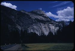
- Description:
- 100 f 8 sl
- Subject:
- North Dome (Mariposa County, Calif.), Yosemite Valley (Calif.), Valleys, Roads, Yosemite National Park (Calif.), Trees, Mountains, National parks & reser...
- Series:
- 22-55
- Creator:
- Cushman, Charles W., 1896-1972
- Date Created:
- 1955-07-09
- Genre:
- Landscape photographs
- Frame Number:
- 3
- County:
- Mariposa
- Abstract:
- North Dome & Royal Arches from valley floor
- Call Number:
- P08256
- Country:
- United States
- State/Province:
- California
- Alternate Identifier:
- 2255.3
- Persistent URL:
- http://purl.dlib.indiana.edu/iudl/archives/cushman/P08256
- Holding Location:
- Bloomington - University Archives
Wells Library E460
1320 E 10th St.
Bloomington, IN 47405
Contact at archives@indiana.edu, 812-855-1127
-
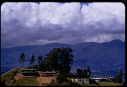
![Mountains of Gabilau Range on east side of Salinas Valley from US 101 [zuni] south of Greenfield, Monterey County](https://iiif.uits.iu.edu/iiif/2/f4752h29j%2Ffiles%2F3fdde8f0-e7ec-432e-891b-88663a382edf/full/250,/0/default.jpg)
- Description:
- 100 f 6.3 tl
- Subject:
- Valleys, Hills, Salinas Valley (Calif.), Gabilan Range (Calif.), Mountains, Dwellings, Trees, Plants, Farms, and Agricultural facilities
- Series:
- 7-55
- Creator:
- Cushman, Charles W., 1896-1972
- Date Created:
- 1955-03-20
- Genre:
- Landscape photographs
- Frame Number:
- 3
- Street Address:
- United States Highway 101
- County:
- Monterey
- Abstract:
- Mtns part of Gabilau range on east side of Salinas Valley from zuni south of Greenfield on US 101
- Call Number:
- P07727
- City:
- Greenfield
- Country:
- United States
- State/Province:
- California
- Alternate Identifier:
- 755.3
- Persistent URL:
- http://purl.dlib.indiana.edu/iudl/archives/cushman/P07727
- Holding Location:
- Bloomington - University Archives
Wells Library E460
1320 E 10th St.
Bloomington, IN 47405
Contact at archives@indiana.edu, 812-855-1127
-
- Description:
- 100 f 8 tl
- Subject:
- Greenwater Range (Calif.), Valleys, Mountains, Shrubs, and Rock formations
- Series:
- 12-55
- Creator:
- Cushman, Charles W., 1896-1972
- Date Created:
- 1955-03-24
- Genre:
- Landscape photographs
- Frame Number:
- 3
- County:
- Inyo
- Abstract:
- Greenwater Mtns west of Shoshone
- Call Number:
- P07899
- City:
- Shoshone
- Country:
- United States
- State/Province:
- California
- Alternate Identifier:
- 1255.3
- Persistent URL:
- http://purl.dlib.indiana.edu/iudl/archives/cushman/P07899
- Holding Location:
- Bloomington - University Archives
Wells Library E460
1320 E 10th St.
Bloomington, IN 47405
Contact at archives@indiana.edu, 812-855-1127
-
- Description:
- 100 f 5.6 TL
- Subject:
- Echo Summit (El Dorado County, Calif.), Trees, Mountains, Tahoe, Lake (Calif. and Nev.), and Lakes & ponds
- Series:
- 25-55
- Creator:
- Cushman, Charles W., 1896-1972
- Date Created:
- 1955-09-24
- Genre:
- Landscape photographs
- Frame Number:
- 3
- Street Address:
- United States Highway 50
- County:
- Placer
- Abstract:
- North from just below (NE) of Echo Summit toward L. Tahoe
- Call Number:
- P08351
- Country:
- United States
- State/Province:
- California
- Alternate Identifier:
- 2555.3
- Persistent URL:
- http://purl.dlib.indiana.edu/iudl/archives/cushman/P08351
- Holding Location:
- Bloomington - University Archives
Wells Library E460
1320 E 10th St.
Bloomington, IN 47405
Contact at archives@indiana.edu, 812-855-1127