
Search Constraints
You searched for:
Campus
IUB
Remove constraint Campus: IUB
Frame Number
3
Remove constraint Frame Number: 3
Subject
Mountains
Remove constraint Subject: Mountains
« Previous |
1 - 50 of 95
|
Next »
Search Results
-
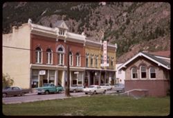
- Description:
- 100 f 11
- Subject:
- Cornices, Sprinklers, Gables, Red Ram (Georgetown, Colo.), Signs (Notices), Streets, Mountains, Buildings, Windows, Architectural decorations & ornaments...
- Series:
- 9-66
- Creator:
- Cushman, Charles W., 1896-1972
- Date Created:
- 1966-06-13
- Genre:
- Cityscape photographs
- Frame Number:
- 3
- County:
- Clear Creek
- Call Number:
- P15406
- City:
- Georgetown
- Country:
- United States
- State/Province:
- Colorado
- Alternate Identifier:
- 966.3
- Persistent URL:
- http://purl.dlib.indiana.edu/iudl/archives/cushman/P15406
- Holding Location:
- Bloomington - University Archives
Wells Library E460
1320 E 10th St.
Bloomington, IN 47405
Contact at archives@indiana.edu, 812-855-1127
-
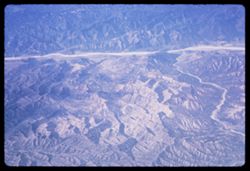
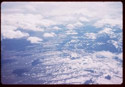
- Description:
- 200 f 5.6
- Subject:
- Pan American World Airways, inc., Channels, Air travel, Mountains, and Rivers
- Series:
- 1-65
- Creator:
- Cushman, Charles W., 1896-1972
- Date Created:
- 1965-03-30
- Genre:
- Aerial photographs and Landscape photographs
- Frame Number:
- 3
- County:
- Los Angeles
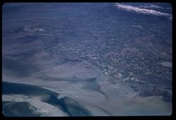
- Abstract:
- Over mountains and fields on way to L.A. and California Fields north of Los Angeles
- Call Number:
- P13867
- City:
- Los Angeles
- Country:
- United States
- State/Province:
- California
- Alternate Identifier:
- 165.3
- Persistent URL:
- http://purl.dlib.indiana.edu/iudl/archives/cushman/P13867
- Holding Location:
- Bloomington - University Archives
Wells Library E460
1320 E 10th St.
Bloomington, IN 47405
Contact at archives@indiana.edu, 812-855-1127
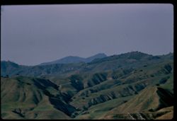
-
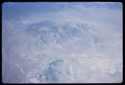
- Description:
- 200 f 5.6
- Subject:
- Valleys, Mountains, Land, Air travel, and Pan American World Airways, inc.
- Series:
- 2-65
- Creator:
- Cushman, Charles W., 1896-1972
- Date Created:
- 1965-03-30
- Genre:
- Aerial photographs and Landscape photographs
- Frame Number:
- 3
- Call Number:
- P13888
- Country:
- United States
- State/Province:
- Utah
- Alternate Identifier:
- 265.3
- Persistent URL:
- http://purl.dlib.indiana.edu/iudl/archives/cushman/P13888
- Holding Location:
- Bloomington - University Archives
Wells Library E460
1320 E 10th St.
Bloomington, IN 47405
Contact at archives@indiana.edu, 812-855-1127
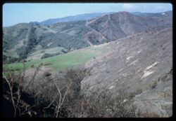
-
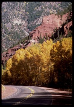
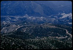
- Description:
- 100 f 11 TL
- Subject:
- Canyons, Forests, Roads, Cliffs, Mountains, Trees, and San Miguel River (Colo.)
- Series:
- 36-65
- Creator:
- Cushman, Charles W., 1896-1972
- Date Created:
- 1965-10-05
- Genre:
- Landscape photographs
- Frame Number:
- 3
- Street Address:
- Colorado State Highway 145
- County:
- San Miguel
- Abstract:
- Rd to Telluride, Colo. Hwy 45.
- Call Number:
- P15071
- City:
- Telluride
- Country:
- United States
- State/Province:
- Colorado
- Alternate Identifier:
- 3665.3
- Persistent URL:
- http://purl.dlib.indiana.edu/iudl/archives/cushman/P15071
- Holding Location:
- Bloomington - University Archives
Wells Library E460
1320 E 10th St.
Bloomington, IN 47405
Contact at archives@indiana.edu, 812-855-1127
-
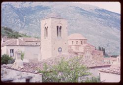
- Description:
- over exposed
- Subject:
- Bell towers, Monasteries, Hosios Loukas (Monastery : Voiotia, Greece), Roofs, Arches, Tree limbs, Mountains, Churches, Clock towers, Domes, and Clocks & ...
- Series:
- 12-65
- Creator:
- Cushman, Charles W., 1896-1972
- Date Created:
- 1965-04-21
- Genre:
- Cityscape photographs and Architectural photographs
- Frame Number:
- 3
- County:
- Voiotia
- Abstract:
- Too light
- Call Number:
- P14241
- Country:
- Greece
- State/Province:
- Central Greece and Euboea
- Alternate Identifier:
- 1265.3
- Persistent URL:
- http://purl.dlib.indiana.edu/iudl/archives/cushman/P14241
- Holding Location:
- Bloomington - University Archives
Wells Library E460
1320 E 10th St.
Bloomington, IN 47405
Contact at archives@indiana.edu, 812-855-1127
-
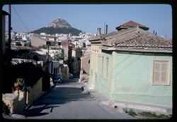
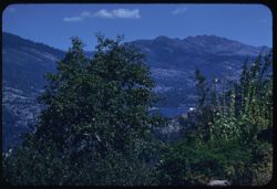
- Subject:
- Automobiles, Likavittós (Greece), Roofs, Streets, Mountains, Buildings, Windows, Dwellings, Plants, Cities & towns, Sidewalks, and Flowerpots
- Series:
- 15-65
- Creator:
- Cushman, Charles W., 1896-1972
- Date Created:
- 1965-04-29
- Genre:
- Cityscape photographs
- Frame Number:
- 3
- Street Address:
- Plaka
- County:
- Attica
- Abstract:
- Likavitos from Plaka
- Call Number:
- P14354
- City:
- Athens
- Country:
- Greece
- State/Province:
- Central Greece and Euboea
- Alternate Identifier:
- 1565.3
- Persistent URL:
- http://purl.dlib.indiana.edu/iudl/archives/cushman/P14354
- Holding Location:
- Bloomington - University Archives
Wells Library E460
1320 E 10th St.
Bloomington, IN 47405
Contact at archives@indiana.edu, 812-855-1127
-
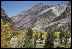
- Description:
- 200 f 8
- Subject:
- Tree limbs, Houses, Forests, Cliffs, Mountains, and Trees
- Series:
- 35-65
- Creator:
- Cushman, Charles W., 1896-1972
- Date Created:
- 1965-10-04
- Genre:
- Landscape photographs
- Frame Number:
- 3
- County:
- Ouray
- Abstract:
- Ouray = cliff NW.
- Call Number:
- P15033
- City:
- Ouray
- Country:
- United States
- State/Province:
- Colorado
- Alternate Identifier:
- 3565.3
- Persistent URL:
- http://purl.dlib.indiana.edu/iudl/archives/cushman/P15033
- Holding Location:
- Bloomington - University Archives
Wells Library E460
1320 E 10th St.
Bloomington, IN 47405
Contact at archives@indiana.edu, 812-855-1127
-
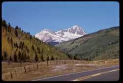
- Description:
- 100 f 16
- Subject:
- Forests, Roads, Mountains, Snow, Trees, Grasses, and Fences
- Series:
- 33-65
- Creator:
- Cushman, Charles W., 1896-1972
- Date Created:
- 1965-10-02
- Genre:
- Landscape photographs
- Frame Number:
- 3
- Street Address:
- United States Highway 550
- County:
- La Plata and San Juan
- Abstract:
- Snow covered Mtn
- Call Number:
- P14958
- City:
- Silverton and Durango
- Country:
- United States
- State/Province:
- Colorado
- Alternate Identifier:
- 3365.3
- Persistent URL:
- http://purl.dlib.indiana.edu/iudl/archives/cushman/P14958
- Holding Location:
- Bloomington - University Archives
Wells Library E460
1320 E 10th St.
Bloomington, IN 47405
Contact at archives@indiana.edu, 812-855-1127
-
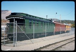
- Description:
- 100 f 11
- Subject:
- Railings, Railroad cabooses, Mountains, Denver and Rio Grande Western Railway Company, Railroad tracks, Railroad cars, Utility poles, Railroads, and Fences
- Series:
- 34-65
- Creator:
- Cushman, Charles W., 1896-1972
- Date Created:
- 1965-10-03
- Genre:
- Identification photographs
- Frame Number:
- 3
- County:
- La Plata
- Abstract:
- Old Rio Grande wooden coaches
- Call Number:
- P14995
- City:
- Durango
- Country:
- United States
- State/Province:
- Colorado
- Alternate Identifier:
- 3465.3
- Persistent URL:
- http://purl.dlib.indiana.edu/iudl/archives/cushman/P14995
- Holding Location:
- Bloomington - University Archives
Wells Library E460
1320 E 10th St.
Bloomington, IN 47405
Contact at archives@indiana.edu, 812-855-1127
-
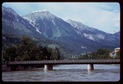
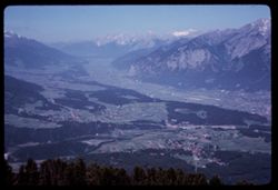
- Description:
- 100 f 11
- Subject:
- Valleys, Forests, Inn River, Bridges, Mountains, Trees, and Rivers
- Series:
- 14-64
- Creator:
- Cushman, Charles W., 1896-1972
- Date Created:
- 1964-06-02
- Genre:
- Landscape photographs
- Frame Number:
- 3
- Abstract:
- The Inn.
- Call Number:
- P13431
- City:
- Innsbruck
- Country:
- Austria
- State/Province:
- Tyrol
- Alternate Identifier:
- 1464.3
- Persistent URL:
- http://purl.dlib.indiana.edu/iudl/archives/cushman/P13431
- Holding Location:
- Bloomington - University Archives
Wells Library E460
1320 E 10th St.
Bloomington, IN 47405
Contact at archives@indiana.edu, 812-855-1127
-
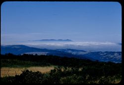
- Description:
- 100 f 11 SL
- Subject:
- Santa Ynez Mountains (Calif.), Tree limbs, Mountains, Disasters, and Fires
- Series:
- 26-64
- Creator:
- Cushman, Charles W., 1896-1972
- Date Created:
- 1964-12-02
- Genre:
- Landscape photographs
- Frame Number:
- 3
- County:
- Santa Barbara
- Abstract:
- After the big fire
- Call Number:
- P13802
- City:
- Santa Barbara
- Country:
- United States
- State/Province:
- California
- Alternate Identifier:
- 2664.3
- Persistent URL:
- http://purl.dlib.indiana.edu/iudl/archives/cushman/P13802
- Holding Location:
- Bloomington - University Archives
Wells Library E460
1320 E 10th St.
Bloomington, IN 47405
Contact at archives@indiana.edu, 812-855-1127
-
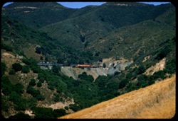
- Description:
- 100 f 11
- Subject:
- Roads, Trees, Mountains, Buildings, Bridges, Railroad tracks, Forests, Hills, Rivers, and Houses
- Series:
- 13-64
- Creator:
- Cushman, Charles W., 1896-1972
- Date Created:
- 1964-05-31
- Genre:
- Landscape photographs and Cityscape photographs
- Frame Number:
- 3
- County:
- Oberbayern
- Abstract:
- Berchtesgaden across the river.
- Call Number:
- P13394
- City:
- Berchtesgaden
- Country:
- Germany
- State/Province:
- Bavaria
- Alternate Identifier:
- 1364.3
- Persistent URL:
- http://purl.dlib.indiana.edu/iudl/archives/cushman/P13394
- Holding Location:
- Bloomington - University Archives
Wells Library E460
1320 E 10th St.
Bloomington, IN 47405
Contact at archives@indiana.edu, 812-855-1127
-
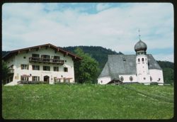
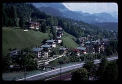
- Description:
- 200 f 8
- Subject:
- Cafes, Meadows, Churches, Umbrellas, Onion domes, Mountains, Trees, Towers, Wildflowers, Fences, and Balconies
- Series:
- 10-64
- Creator:
- Cushman, Charles W., 1896-1972
- Date Created:
- 1964-05-25
- Genre:
- Architectural photographs
- Frame Number:
- 3
- County:
- Oberbayern
- Abstract:
- Trip to Berchtesgaden
- Call Number:
- P13281
- City:
- Berchtesgaden
- Country:
- Germany
- State/Province:
- Bavaria
- Alternate Identifier:
- 1064.3
- Persistent URL:
- http://purl.dlib.indiana.edu/iudl/archives/cushman/P13281
- Holding Location:
- Bloomington - University Archives
Wells Library E460
1320 E 10th St.
Bloomington, IN 47405
Contact at archives@indiana.edu, 812-855-1127
-
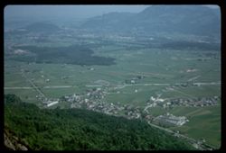
- Description:
- 200 f 5.6
- Subject:
- Croplands, Meadows, Houses, Forests, Untersberg (Austria), Mountains, Buildings, and Hills
- Series:
- 9-64
- Creator:
- Cushman, Charles W., 1896-1972
- Date Created:
- 1964-05-24
- Genre:
- Landscape photographs and Cityscape photographs
- Frame Number:
- 3
- Call Number:
- P13243
- City:
- Salzburg
- Country:
- Austria
- State/Province:
- Salzburg
- Alternate Identifier:
- 964.3
- Persistent URL:
- http://purl.dlib.indiana.edu/iudl/archives/cushman/P13243
- Holding Location:
- Bloomington - University Archives
Wells Library E460
1320 E 10th St.
Bloomington, IN 47405
Contact at archives@indiana.edu, 812-855-1127
-
- Description:
- 100 f 11
- Subject:
- Snow, Valleys, Inn River, Inn River Valley, Croplands, Forests, Hills, Patscherkofel (Austria), Mountains, Alps, Austrian (Austria), and Rivers
- Series:
- 15-64
- Creator:
- Cushman, Charles W., 1896-1972
- Date Created:
- 1964-06-04
- Genre:
- Landscape photographs
- Frame Number:
- 3
- Call Number:
- P13468
- City:
- Innsbruck
- Country:
- Austria
- State/Province:
- Tyrol
- Alternate Identifier:
- 1564.3
- Persistent URL:
- http://purl.dlib.indiana.edu/iudl/archives/cushman/P13468
- Holding Location:
- Bloomington - University Archives
Wells Library E460
1320 E 10th St.
Bloomington, IN 47405
Contact at archives@indiana.edu, 812-855-1127
-
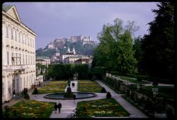
- Description:
- 100 f 5.6
- Subject:
- Pedestrians, Fountains, Forts & fortifications, Trees, Gardens, Mountains, Festung Hohensalzburg (Salzburg, Austria), Shrubs, Garden walls, Steeples, Cat...
- Series:
- 8-64
- Creator:
- Cushman, Charles W., 1896-1972
- Date Created:
- 1964-05-21
- Genre:
- Views and Cityscape photographs
- Frame Number:
- 3
- Abstract:
- Hohensalzberg Fortress from Mirabell Garden
- Call Number:
- P13205
- City:
- Salzburg
- Country:
- Austria
- State/Province:
- Salzburg
- Alternate Identifier:
- 864.3
- Persistent URL:
- http://purl.dlib.indiana.edu/iudl/archives/cushman/P13205
- Holding Location:
- Bloomington - University Archives
Wells Library E460
1320 E 10th St.
Bloomington, IN 47405
Contact at archives@indiana.edu, 812-855-1127
-
- Description:
- 200 f 5.6 ?
- Subject:
- Snow, Mountains, Air travel, Land, and Wasatch Range (Utah and Idaho)
- Series:
- 2-64
- Creator:
- Cushman, Charles W., 1896-1972
- Date Created:
- 1964-04-29
- Genre:
- Aerial photographs
- Frame Number:
- 3
- County:
- Weber
- Abstract:
- Ogden
- Call Number:
- P12995
- City:
- Ogden
- Country:
- United States
- State/Province:
- Utah
- Alternate Identifier:
- 264.3
- Persistent URL:
- http://purl.dlib.indiana.edu/iudl/archives/cushman/P12995
- Holding Location:
- Bloomington - University Archives
Wells Library E460
1320 E 10th St.
Bloomington, IN 47405
Contact at archives@indiana.edu, 812-855-1127
-

- Description:
- 50 f 5.6 SL
- Subject:
- Echo Summit (El Dorado County, Calif.), Trees, Mountains, Sierra Nevada (Calif. and Nev.), Forests, and Hills
- Series:
- 3-62
- Creator:
- Cushman, Charles W., 1896-1972
- Date Created:
- 1962-09-28
- Genre:
- Landscape photographs
- Frame Number:
- 3
- Abstract:
- Down from Echo Sum.
- Call Number:
- P12701
- Country:
- United States
- State/Province:
- California
- Alternate Identifier:
- 362.3
- Persistent URL:
- http://purl.dlib.indiana.edu/iudl/archives/cushman/P12701
- Holding Location:
- Bloomington - University Archives
Wells Library E460
1320 E 10th St.
Bloomington, IN 47405
Contact at archives@indiana.edu, 812-855-1127
-
- Description:
- 100 f 6.3 TL
- Subject:
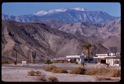
- Stores & shops, Roads, Markets, San Jacinto Peak (Calif.), Signs (Notices), Mountains, Shrubs, Utility poles, and Palms
- Series:
- 24-61
- Creator:
- Cushman, Charles W., 1896-1972
- Date Created:
- 1961-12-25
- Genre:
- Landscape photographs
- Frame Number:
- 3
- County:
- Riverside
- Abstract:
- San Jacinto
- Call Number:
- P12569
- Country:
- United States
- State/Province:
- California
- Alternate Identifier:
- 2461.3
- Persistent URL:
- http://purl.dlib.indiana.edu/iudl/archives/cushman/P12569
- Holding Location:
- Bloomington - University Archives
Wells Library E460
1320 E 10th St.
Bloomington, IN 47405
Contact at archives@indiana.edu, 812-855-1127
-
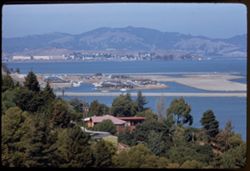
- Description:
- 100 f 6.3 TL
- Subject:
- Paradise Bay (Marin County, Calif.), Hills, Mountains, Trees, Piers & wharves, Houses, Bays (Bodies of water), and Buildings
- Series:
- 22-61
- Creator:
- Cushman, Charles W., 1896-1972
- Date Created:
- 1961-10-06
- Genre:
- Marine photographs and Cityscape photographs
- Frame Number:
- 3
- County:
- Marin
- Abstract:
- Paradise Cay
- Call Number:
- P12494
- Country:
- United States
- State/Province:
- California
- Alternate Identifier:
- 2261.3
- Persistent URL:
- http://purl.dlib.indiana.edu/iudl/archives/cushman/P12494
- Holding Location:
- Bloomington - University Archives
Wells Library E460
1320 E 10th St.
Bloomington, IN 47405
Contact at archives@indiana.edu, 812-855-1127
-
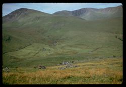
- Description:
- 500 f 2.5
- Subject:
- Meadows, Valleys, Houses, Mountains, Railroad travel, Grasses, Snowdon (Wales), and Stone walls
- Series:
- 12-61
- Creator:
- Cushman, Charles W., 1896-1972
- Date Created:
- 1961-05-25
- Genre:
- Landscape photographs
- Frame Number:
- 3
- Call Number:
- P12125
- Country:
- United Kingdom
- State/Province:
- Wales
- Alternate Identifier:
- 1261.3
- Persistent URL:
- http://purl.dlib.indiana.edu/iudl/archives/cushman/P12125
- Holding Location:
- Bloomington - University Archives
Wells Library E460
1320 E 10th St.
Bloomington, IN 47405
Contact at archives@indiana.edu, 812-855-1127
-
- Subject:
- Snow, Pan American World Airways, inc., Mountains, Clouds, Hills, and Polar Jet
- Series:
- 3-61
- Creator:
- Cushman, Charles W., 1896-1972
- Date Created:
- 1961-04-21
- Genre:
- Aerial photographs
- Frame Number:
- 3
- Call Number:
- P11791
- Alternate Identifier:
- 361.3
- Persistent URL:
- http://purl.dlib.indiana.edu/iudl/archives/cushman/P11791
- Holding Location:
- Bloomington - University Archives
Wells Library E460
1320 E 10th St.
Bloomington, IN 47405
Contact at archives@indiana.edu, 812-855-1127
-
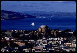
- Description:
- 100 f 8 tl
- Subject:
- Domes, San Francisco Bay Area (Calif.), Palace of Fine Arts (San Francisco), Sailboats, Columns, Mountains, Buildings, Rotundas, Hills, Bays (Bodies of water...
- Series:
- 1-60
- Creator:
- Cushman, Charles W., 1896-1972
- Date Created:
- 1960-01-16
- Genre:
- Marine photographs, Cityscape photographs, and Views
- Frame Number:
- 3
- Street Address:
- Broderick Street and Broadway Street
- County:
- San Francisco
- Abstract:
- North Bay from Broadway + Broderick
- Call Number:
- P10897
- City:
- San Francisco
- Country:
- United States
- State/Province:
- California
- Alternate Identifier:
- 160.3
- Persistent URL:
- http://purl.dlib.indiana.edu/iudl/archives/cushman/P10897
- Holding Location:
- Bloomington - University Archives
Wells Library E460
1320 E 10th St.
Bloomington, IN 47405
Contact at archives@indiana.edu, 812-855-1127
-
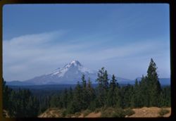
- Description:
- 100 f 9 tl
- Subject:
- Snow, Cascade Range, Trees, Mountains, Hood, Mount (Or.), Shrubs, Forests, and Hills
- Series:
- 24-60
- Creator:
- Cushman, Charles W., 1896-1972
- Date Created:
- 1960-09-17
- Genre:
- Landscape photographs
- Frame Number:
- 3
- County:
- Clackamas
- Abstract:
- Mt. Hood from south
- Call Number:
- P11658
- Country:
- United States
- State/Province:
- Oregon
- Alternate Identifier:
- 2460.3
- Persistent URL:
- http://purl.dlib.indiana.edu/iudl/archives/cushman/P11658
- Holding Location:
- Bloomington - University Archives
Wells Library E460
1320 E 10th St.
Bloomington, IN 47405
Contact at archives@indiana.edu, 812-855-1127
-
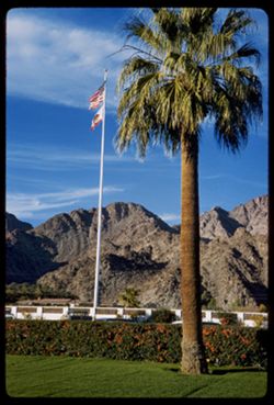
- Description:
- 50 f 8
- Subject:
- Walls, Hedges (Plants), State flags, Flags, Mountains, Lawns, Flagpoles, and Palms
- Series:
- 27-60
- Creator:
- Cushman, Charles W., 1896-1972
- Date Created:
- 1960-12-26
- Genre:
- Landscape photographs
- Frame Number:
- 3
- County:
- Riverside
- Abstract:
- La Quinta- flagstaff and palm
- Call Number:
- P11745
- City:
- La Quinta
- Country:
- United States
- State/Province:
- California
- Alternate Identifier:
- 2760.3
- Persistent URL:
- http://purl.dlib.indiana.edu/iudl/archives/cushman/P11745
- Holding Location:
- Bloomington - University Archives
Wells Library E460
1320 E 10th St.
Bloomington, IN 47405
Contact at archives@indiana.edu, 812-855-1127
-
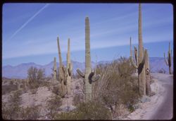
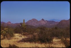
- Description:
- 50 f 11 sl
- Subject:
- Deserts, Roads, Cactus, Mountains, Shrubs, and Saguaro National Park (Ariz.)
- Series:
- 10-59
- Creator:
- Cushman, Charles W., 1896-1972
- Date Created:
- 1959-03-03
- Frame Number:
- 3
- County:
- Pima
- Abstract:
- View north
- Call Number:
- P10691
- City:
- Tucson
- Country:
- United States
- State/Province:
- Arizona
- Alternate Identifier:
- 1059.3
- Persistent URL:
- http://purl.dlib.indiana.edu/iudl/archives/cushman/P10691
- Holding Location:
- Bloomington - University Archives
Wells Library E460
1320 E 10th St.
Bloomington, IN 47405
Contact at archives@indiana.edu, 812-855-1127
-
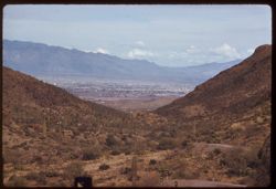
- Description:
- 100 f 6.3 tl
- Subject:
- Roads, Cactus, Cities & towns, Buildings, Gates Pass (Ariz.), Tucson Mountains (Ariz.), Clouds, Dwellings, Mountains, Shrubs, and Traffic signs & sig...
- Series:
- 8-59
- Creator:
- Cushman, Charles W., 1896-1972
- Date Created:
- 1959-02-11
- Genre:
- Cityscape photographs
- Frame Number:
- 3
- County:
- Pima
- Abstract:
- Tucson seen from Gates Pass in Tuscon Mtns.
- Call Number:
- P10617
- City:
- Tucson
- Country:
- United States
- State/Province:
- Arizona
- Alternate Identifier:
- 859.3
- Persistent URL:
- http://purl.dlib.indiana.edu/iudl/archives/cushman/P10617
- Holding Location:
- Bloomington - University Archives
Wells Library E460
1320 E 10th St.
Bloomington, IN 47405
Contact at archives@indiana.edu, 812-855-1127
-
- Description:
- 100 f 6.3 tl
- Subject:
- Cactus, Mountains, Shrubs, and Vulture Mountains (Ariz.)
- Series:
- 11-59
- Creator:
- Cushman, Charles W., 1896-1972
- Date Created:
- 1959-03-23
- Genre:
- Landscape photographs
- Frame Number:
- 3
- County:
- Maricopa
- Abstract:
- The mtn with penthouse late light
- Call Number:
- P10728
- City:
- Wickenburg
- Country:
- United States
- State/Province:
- Arizona
- Alternate Identifier:
- 1159.3
- Persistent URL:
- http://purl.dlib.indiana.edu/iudl/archives/cushman/P10728
- Holding Location:
- Bloomington - University Archives
Wells Library E460
1320 E 10th St.
Bloomington, IN 47405
Contact at archives@indiana.edu, 812-855-1127
-
- Description:
- 100 f 8 tl
- Subject:
- Rocks, Cactus, Buttes, Mountains, Shrubs, Tucson Mountains (Ariz.), and Clouds
- Series:
- 7-59
- Creator:
- Cushman, Charles W., 1896-1972
- Date Created:
- 1959-02-02
- Genre:
- Landscape photographs
- Frame Number:
- 3
- Street Address:
- Ajo Way
- County:
- Pima
- Abstract:
- A small butte commercialized
- Call Number:
- P10579
- City:
- Tucson
- Country:
- United States
- State/Province:
- Arizona
- Alternate Identifier:
- 759.3
- Persistent URL:
- http://purl.dlib.indiana.edu/iudl/archives/cushman/P10579
- Holding Location:
- Bloomington - University Archives
Wells Library E460
1320 E 10th St.
Bloomington, IN 47405
Contact at archives@indiana.edu, 812-855-1127
-
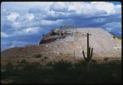
- Description:
- 100 f 9 tl
- Subject:
- Cactus, Mountains, Shrubs, and Roskruge Mountains (Ariz.)
- Series:
- 9-59
- Creator:
- Cushman, Charles W., 1896-1972
- Date Created:
- 1959-02-20
- Genre:
- Landscape photographs
- Frame Number:
- 3
- Street Address:
- Ajo Way
- County:
- Pima
- Abstract:
- Roskruge Mtns. -from Ajo road
- Call Number:
- P10654
- City:
- Tucson
- Country:
- United States
- State/Province:
- Arizona
- Alternate Identifier:
- 959.3
- Persistent URL:
- http://purl.dlib.indiana.edu/iudl/archives/cushman/P10654
- Holding Location:
- Bloomington - University Archives
Wells Library E460
1320 E 10th St.
Bloomington, IN 47405
Contact at archives@indiana.edu, 812-855-1127
-
- Description:
- 100 f 6.3 tl
- Subject:
- Meadows, Lorenz Lumber Company Mill (Burney, Calif.), Mountains, Clouds, Firs, Haynes Ranch (Burney, Calif.), Lumber industry, and Forests
- Series:
- 10-58
- Creator:
- Cushman, Charles W., 1896-1972
- Date Created:
- 1958-06-12
- Genre:
- Landscape photographs
- Frame Number:
- 3
- County:
- Shasta
- Abstract:
- Mill and meadow Haynes Ranch
- Call Number:
- P09941
- City:
- Burney
- Country:
- United States
- State/Province:
- California
- Alternate Identifier:
- 1058.3
- Persistent URL:
- http://purl.dlib.indiana.edu/iudl/archives/cushman/P09941
- Holding Location:
- Bloomington - University Archives
Wells Library E460
1320 E 10th St.
Bloomington, IN 47405
Contact at archives@indiana.edu, 812-855-1127
-
- Description:
- 50 f 8 sl
- Subject:
- Channels, Men, Automobiles, San Francisco Bay (Calif.), Mountains, Golden Gate Bridge (San Francisco, Calif.), Suspension bridges, and Zephyr automobile
- Series:
- 1-58
- Creator:
- Cushman, Charles W., 1896-1972
- Date Created:
- 1958-01-13
- Genre:
- Portraits and Snapshots
- Frame Number:
- 3
- County:
- San Francisco
- Persons Pictured:
- Cushman, Charles W. (Charles Weever), 1896-1972
- Abstract:
- Charles
- Call Number:
- P09663
- City:
- San Francisco
- Country:
- United States
- State/Province:
- California
- Alternate Identifier:
- 158.3
- Persistent URL:
- http://purl.dlib.indiana.edu/iudl/archives/cushman/P09663
- Holding Location:
- Bloomington - University Archives
Wells Library E460
1320 E 10th St.
Bloomington, IN 47405
Contact at archives@indiana.edu, 812-855-1127
-
- Description:
- 100 f 6.3 tl hf
- Subject:
- Forest fires, Smoke, Plains, Mountains, and Oquirrh Mountains (Utah)
- Series:
- 16-58
- Creator:
- Cushman, Charles W., 1896-1972
- Date Created:
- 1958-08-23
- Genre:
- Landscape photographs
- Frame Number:
- 3
- Street Address:
- United States Highway 40
- County:
- Salt Lake
- Abstract:
- West slope of Oquirrh Mtn. From US 40, 25 mi. w of Salt Lake City
- Call Number:
- P10129
- City:
- Salt Lake City
- Country:
- United States
- State/Province:
- Utah
- Alternate Identifier:
- 1658.3
- Persistent URL:
- http://purl.dlib.indiana.edu/iudl/archives/cushman/P10129
- Holding Location:
- Bloomington - University Archives
Wells Library E460
1320 E 10th St.
Bloomington, IN 47405
Contact at archives@indiana.edu, 812-855-1127
-
- Description:
- 100 f 6.3 tl
- Subject:
- Emigrant Gap (Calif. : Gap), Trees, Mountains, Lakes & ponds, Sierra Nevada (Calif. and Nev.), and Plants
- Series:
- 15-58
- Creator:
- Cushman, Charles W., 1896-1972
- Date Created:
- 1958-08-22
- Genre:
- Landscape photographs
- Frame Number:
- 3
- Abstract:
- Toward mtns east of Emigrant Gap
- Call Number:
- P10109
- Country:
- United States
- State/Province:
- California and Nevada
- Alternate Identifier:
- 1558.3
- Persistent URL:
- http://purl.dlib.indiana.edu/iudl/archives/cushman/P10109
- Holding Location:
- Bloomington - University Archives
Wells Library E460
1320 E 10th St.
Bloomington, IN 47405
Contact at archives@indiana.edu, 812-855-1127
-
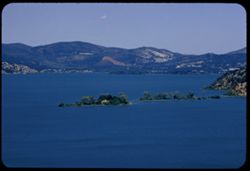
- Description:
- 100 f 8 tl
- Subject:
- Trees, Mountains, Lakes & ponds, Islands, Hills, and Clear Lake (Lake County, Calif.)
- Series:
- 10-57
- Creator:
- Cushman, Charles W., 1896-1972
- Date Created:
- 1957-06-30
- Genre:
- Landscape photographs
- Frame Number:
- 3
- County:
- Lake
- Abstract:
- East across waist of Cl. Lk from Buckingham Pk
- Call Number:
- P09377
- City:
- Buckingham Park
- Country:
- United States
- State/Province:
- California
- Alternate Identifier:
- 1057.3
- Persistent URL:
- http://purl.dlib.indiana.edu/iudl/archives/cushman/P09377
- Holding Location:
- Bloomington - University Archives
Wells Library E460
1320 E 10th St.
Bloomington, IN 47405
Contact at archives@indiana.edu, 812-855-1127
-

- Description:
- 100 f 6.3 tl
- Subject:
- Gabilan Range (Calif.), Trees, Croplands, Salinas River Valley (Calif.), and Mountains
- Series:
- 18-57
- Creator:
- Cushman, Charles W., 1896-1972
- Date Created:
- 1957-11-30
- Genre:
- Landscape photographs
- Frame Number:
- 3
- County:
- Monterey
- Abstract:
- Camel-shaped mountain of Gabilan Range SE of Soledad
- Call Number:
- P09626
- City:
- Soledad
- Country:
- United States
- State/Province:
- California
- Alternate Identifier:
- 1857.3
- Persistent URL:
- http://purl.dlib.indiana.edu/iudl/archives/cushman/P09626
- Holding Location:
- Bloomington - University Archives
Wells Library E460
1320 E 10th St.
Bloomington, IN 47405
Contact at archives@indiana.edu, 812-855-1127
-
- Description:
- 100 f 6.3 tl
- Subject:
- Santa Ynez River Valley (Calif.), Meadows, Bradbury Dam (Calif.), Mountains, Shrubs, and Cachuma, Lake (Calif.)
- Series:
- 15-57
- Creator:
- Cushman, Charles W., 1896-1972
- Date Created:
- 1957-09-20
- Genre:
- Landscape photographs
- Frame Number:
- 3
- County:
- Santa Barbara
- Abstract:
- From height above Cachuma Dam - views north & eastward
- Call Number:
- P09538
- Country:
- United States
- State/Province:
- California
- Alternate Identifier:
- 1557.3
- Persistent URL:
- http://purl.dlib.indiana.edu/iudl/archives/cushman/P09538
- Holding Location:
- Bloomington - University Archives
Wells Library E460
1320 E 10th St.
Bloomington, IN 47405
Contact at archives@indiana.edu, 812-855-1127
-
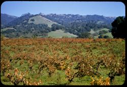
- Description:
- 50 f 6.3 sl
- Subject:
- Grapevines, Trees, Meadows, Mountains, Grapes, Hills, and Alexander Valley (Calif.)
- Series:
- 16-57
- Creator:
- Cushman, Charles W., 1896-1972
- Date Created:
- 1957-11-05
- Genre:
- Landscape photographs
- Frame Number:
- 3
- Street Address:
- California State Highway 128
- County:
- Sonoma
- Call Number:
- P09569
- Country:
- United States
- State/Province:
- California
- Alternate Identifier:
- 1657.3
- Persistent URL:
- http://purl.dlib.indiana.edu/iudl/archives/cushman/P09569
- Holding Location:
- Bloomington - University Archives
Wells Library E460
1320 E 10th St.
Bloomington, IN 47405
Contact at archives@indiana.edu, 812-855-1127
-
- Description:
- 100 f 8 tl
- Subject:
- Canyons, Cajon Canyon (Calif.), Roads, Mountains, Hills, and Cajon Pass (Calif.)
- Series:
- 7-57
- Creator:
- Cushman, Charles W., 1896-1972
- Date Created:
- 1957-05-14
- Genre:
- Landscape photographs
- Frame Number:
- 3
- Street Address:
- United States Highway 66
- County:
- San Bernardino
- Abstract:
- View SW & W from high point on US 66 through Cajon Pass (4255') Down into Cajon canyon
- Call Number:
- P09282
- Country:
- United States
- State/Province:
- California
- Alternate Identifier:
- 957.3
- Persistent URL:
- http://purl.dlib.indiana.edu/iudl/archives/cushman/P09282
- Holding Location:
- Bloomington - University Archives
Wells Library E460
1320 E 10th St.
Bloomington, IN 47405
Contact at archives@indiana.edu, 812-855-1127
-
- Description:
- 100 f 8 tl
- Subject:
- Fog, Mountains, Shrubs, Tamalpais, Mount (Calif.), and Hills
- Series:
- 13-57
- Creator:
- Cushman, Charles W., 1896-1972
- Date Created:
- 1957-08-17
- Genre:
- Landscape photographs
- Frame Number:
- 3
- Street Address:
- 12180 Skyline Drive
- County:
- San Mateo
- Persons Pictured:
- Lolla
- Abstract:
- Fog bank at Tamalpais from Skyline Dr. at Mr. Lolla's, 12180.
- Call Number:
- P09482
- Country:
- United States
- State/Province:
- California
- Alternate Identifier:
- 1357.3
- Persistent URL:
- http://purl.dlib.indiana.edu/iudl/archives/cushman/P09482
- Holding Location:
- Bloomington - University Archives
Wells Library E460
1320 E 10th St.
Bloomington, IN 47405
Contact at archives@indiana.edu, 812-855-1127
-
- Description:
- 100 f 6.3 tl
- Subject:
- Meadows, Mountains, Trees, Buttes, and Sutter Buttes (Calif.)
- Series:
- 11-57
- Creator:
- Cushman, Charles W., 1896-1972
- Date Created:
- 1957-07-22
- Genre:
- Landscape photographs
- Frame Number:
- 3
- Abstract:
- Sutter Buttes Hazy
- Call Number:
- P09412
- Country:
- United States
- State/Province:
- California
- Alternate Identifier:
- 1157.3
- Persistent URL:
- http://purl.dlib.indiana.edu/iudl/archives/cushman/P09412
- Holding Location:
- Bloomington - University Archives
Wells Library E460
1320 E 10th St.
Bloomington, IN 47405
Contact at archives@indiana.edu, 812-855-1127
-
- Description:
- 100 f 5.6 sl
- Subject:
- Feather River Canyon (Calif.), Canyons, Forests, Railroad tracks, Mountains, Electric lines, Trees, Feather River (Calif.), Rivers, and Tree limbs
- Series:
- 12-57
- Creator:
- Cushman, Charles W., 1896-1972
- Date Created:
- 1957-07-25
- Genre:
- Landscape photographs
- Frame Number:
- 3
- County:
- Plumas
- Abstract:
- View down canyon
- Call Number:
- P09448
- City:
- Cromberg
- Country:
- United States
- State/Province:
- California
- Alternate Identifier:
- 1257.3
- Persistent URL:
- http://purl.dlib.indiana.edu/iudl/archives/cushman/P09448
- Holding Location:
- Bloomington - University Archives
Wells Library E460
1320 E 10th St.
Bloomington, IN 47405
Contact at archives@indiana.edu, 812-855-1127
-
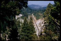
- Description:
- 100 f 4.5 tl
- Subject:
- Canyons, Grasses, Cuesta Pass (Calif.), Southern Pacific Railroad Company, Mountains, Shrubs, Railroad passenger cars, Passes (Landforms), Embankments, Railr...
- Series:
- 14-57
- Creator:
- Cushman, Charles W., 1896-1972
- Date Created:
- 1957-09-19
- Genre:
- Landscape photographs and Snapshots
- Frame Number:
- 3
- County:
- San Luis Obispo
- Abstract:
- Sou. Pac. passenger train north bound
- Call Number:
- P09502
- Country:
- United States
- State/Province:
- California
- Alternate Identifier:
- 1457.3
- Persistent URL:
- http://purl.dlib.indiana.edu/iudl/archives/cushman/P09502
- Holding Location:
- Bloomington - University Archives
Wells Library E460
1320 E 10th St.
Bloomington, IN 47405
Contact at archives@indiana.edu, 812-855-1127
-
- Description:
- 100 f 8 TL
- Subject:
- Valleys, Mustang Ridge (Monterey County, Calif.), Mountains, Hills, Peachtree Valley (Calif.), and Canyons
- Series:
- 6-56
- Creator:
- Cushman, Charles W., 1896-1972
- Date Created:
- 1956-04-21
- Genre:
- Landscape photographs
- Frame Number:
- 3
- Street Address:
- California State Highway 198
- County:
- Monterey
- Abstract:
- View northward across deep (peach tree Valley) from 198 - 13 mi. east of San Lucas toward Mustang Ridge
- Call Number:
- P08713
- City:
- San Lucas
- Country:
- United States
- State/Province:
- California
- Alternate Identifier:
- 656.3
- Persistent URL:
- http://purl.dlib.indiana.edu/iudl/archives/cushman/P08713
- Holding Location:
- Bloomington - University Archives
Wells Library E460
1320 E 10th St.
Bloomington, IN 47405
Contact at archives@indiana.edu, 812-855-1127
-
- Description:
- 100 f 6.3 tl
- Subject:
- Shasta Lake (Calif.), Trees, Coastlines, Mountains, and Lakes & ponds
- Series:
- 11-56
- Creator:
- Cushman, Charles W., 1896-1972
- Date Created:
- 1956-07-14
- Genre:
- Landscape photographs
- Frame Number:
- 3
- County:
- Shasta
- Abstract:
- Shasta Lake near O'Brien
- Call Number:
- P08901
- City:
- O'Brien
- Country:
- United States
- State/Province:
- California
- Alternate Identifier:
- 1156.3
- Persistent URL:
- http://purl.dlib.indiana.edu/iudl/archives/cushman/P08901
- Holding Location:
- Bloomington - University Archives
Wells Library E460
1320 E 10th St.
Bloomington, IN 47405
Contact at archives@indiana.edu, 812-855-1127
-
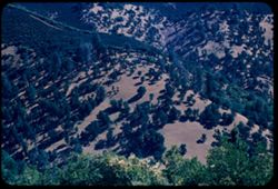
- Description:
- 100 f 5.6 tl
- Subject:
- Mountains, Trees, and Shrubs
- Series:
- 17-55
- Creator:
- Cushman, Charles W., 1896-1972
- Date Created:
- 1955-06-16
- Frame Number:
- 3
- County:
- Trinity and Shasta
- Abstract:
- Tree dotted mtn slope in Shasta County [65568 mi]
- Call Number:
- P08085
- City:
- Weaverville
- Country:
- United States
- State/Province:
- California
- Alternate Identifier:
- 1755.3
- Persistent URL:
- http://purl.dlib.indiana.edu/iudl/archives/cushman/P08085
- Holding Location:
- Bloomington - University Archives
Wells Library E460
1320 E 10th St.
Bloomington, IN 47405
Contact at archives@indiana.edu, 812-855-1127
-
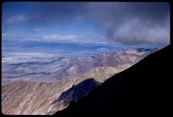
- Description:
- 50 mm lens
- Subject:
- Valleys, Dantes View (Calif.), Mountains, Death Valley (Calif. and Nev.), Black Mountains (Inyo County, Calif.), and Clouds
- Series:
- 3-55
- Creator:
- Cushman, Charles W., 1896-1972
- Date Created:
- 1955-02-27
- Genre:
- Landscape photographs
- Frame Number:
- 3
- County:
- Inyo
- Abstract:
- View north along ridge of Black Mtns
- Call Number:
- P07596
- Country:
- United States
- State/Province:
- California
- Alternate Identifier:
- 355.3
- Persistent URL:
- http://purl.dlib.indiana.edu/iudl/archives/cushman/P07596
- Holding Location:
- Bloomington - University Archives
Wells Library E460
1320 E 10th St.
Bloomington, IN 47405
Contact at archives@indiana.edu, 812-855-1127
-
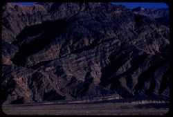
- Description:
- 100 f 6.3 tl
- Subject:
- Valleys, Death Valley (Calif. and Nev.), Mountains, and Tucki Mountain (Calif.)
- Series:
- 8-55
- Creator:
- Cushman, Charles W., 1896-1972
- Date Created:
- 1955-03-21
- Genre:
- Landscape photographs
- Frame Number:
- 3
- Street Address:
- California State Highway 190
- County:
- Inyo
- Abstract:
- South toward Tucki Mtn from near Stovepipe Wells
- Call Number:
- P07764
- City:
- Stovepipe Wells
- Country:
- United States
- State/Province:
- California
- Alternate Identifier:
- 855.3
- Persistent URL:
- http://purl.dlib.indiana.edu/iudl/archives/cushman/P07764
- Holding Location:
- Bloomington - University Archives
Wells Library E460
1320 E 10th St.
Bloomington, IN 47405
Contact at archives@indiana.edu, 812-855-1127
-
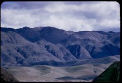
- Description:
- 100 f 5 tl
- Subject:
- Hills, Roads, Mountains, Trees, Buildings, Clouds, and Greenhorn Mountains (Calif.)
- Series:
- 2-55
- Creator:
- Cushman, Charles W., 1896-1972
- Date Created:
- 1955-02-26
- Genre:
- Landscape photographs
- Frame Number:
- 3
- Street Address:
- California State Highway 178
- County:
- Kern
- Abstract:
- From pt. 12 mi E of Bakersfield view east toward Greenhorn Mtns
- Call Number:
- P07561
- City:
- Bakersfield
- Country:
- United States
- State/Province:
- California
- Alternate Identifier:
- 255.3
- Persistent URL:
- http://purl.dlib.indiana.edu/iudl/archives/cushman/P07561
- Holding Location:
- Bloomington - University Archives
Wells Library E460
1320 E 10th St.
Bloomington, IN 47405
Contact at archives@indiana.edu, 812-855-1127
-
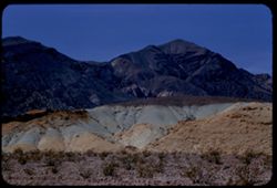
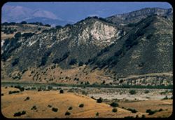
- Description:
- 100 f 8 tl
- Subject:
- Valleys, Buttes, Mountains, Shrubs, Death Valley National Park (Calif. and Nev.), and Black Mountains (Inyo County, Calif.)
- Series:
- 9-55
- Creator:
- Cushman, Charles W., 1896-1972
- Date Created:
- 1955-03-22
- Genre:
- Landscape photographs
- Frame Number:
- 3
- County:
- Inyo
- Abstract:
- Green & brown butte below east side of Black Mtns
- Call Number:
- P07795
- Country:
- United States
- State/Province:
- California
- Alternate Identifier:
- 955.3
- Persistent URL:
- http://purl.dlib.indiana.edu/iudl/archives/cushman/P07795
- Holding Location:
- Bloomington - University Archives
Wells Library E460
1320 E 10th St.
Bloomington, IN 47405
Contact at archives@indiana.edu, 812-855-1127