The Pauline Montgomery Indiana Tombstone Photographs collection contains approximately 1,600 images of grave markers. The images from the 1960s were predomin...
The Gugler collection contains a variety of formats such as posters, handbills, flyers, lobby and window cards, and postcards used to promote films created by and featuring African and Middle Eastern filmmakers and artists. The items represent a wide range of countries throughout these regions and include nearly 1200 posters and 12 boxes of smaller sized promotional items representing over 500 unique works by approximately 350 filmmakers. French and German releases of films are particularly well represented, but a large number of items are also in Polish, Arabic, Hebrew, Japanese, and various other languages. More information on the Gugler collection is available at: http://purl.dlib.indiana.edu/iudl/findingaids/bfca/VAD5484.
The William and Gayle Cook Music Library, recognized as one of the largest academic music libraries in the world, serves the world-renowned Jacobs School of ...
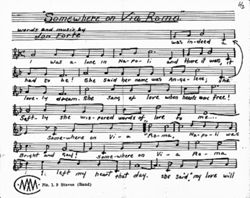
Materials collected from the composition studio of Leonard Bernstein, a conductor, composer, and musician active during the mid-20th century. The collection ...
General meetings of the Indiana University faculty began in 1835, to discuss the industriousness of its students, calling student rolls, and hearing reports ...
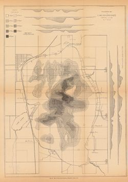
Indiana Historic Maps provides images of a small portion of maps that focus on Indiana. The majority of this collection focuses on maps produced prior to 1923 unless known to be in the public domain as state or federal documents. In addition, Indiana University Bloomington holds an outstanding collection of print maps by and about geographic areas covering the state of Indiana. Most well known of these are the Sanborn Fire Insurance maps which have been digitized through 1923 and now available at: https://libraries.indiana.edu/union-list-sanborn-maps. In addition we own many maps produced by Indiana State government agencies including state and county highway maps, IGS geologic maps and DNR park maps; U.S. Federal agencies such as the USGS topographic maps, Congressional survey maps and AMS maps from the 1940s; as well as privately produced maps for the state but also cities and counties.
The IUB Map Collections contain digitized public domain maps from the Indiana University Bloomington Libraries print map collections. Maps in the digital collection range from the early nineteenth century to the present and feature: Geologic, topographic, and highway maps of Indiana in the Indiana Historic Maps Collection; Russian military topographic maps produced for defense and economic planning in the Russian Military Topographic Map Collection. The print IUB Map Collections are located on the 2nd floor of the East Tower of the Herman B Wells Library, 1320 East Tenth Street, Bloomington, Indiana 47405. To suggest maps to add to the digital collection or for more information, please contact us at libgimms@indiana.edu.
This collection includes photographs documenting the activities of the Black Filmmakers Hall of Fame as well as images used to publicize film screenings and ...

 2265Works
 2223Works
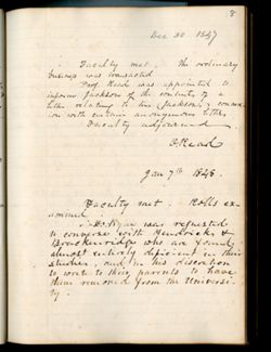 1958Works
 1325Works