
Search Constraints
You searched for:
Campus
IUB
Remove constraint Campus: IUB
Type
Image
Remove constraint Type: Image
Pages
0-99 pages
Remove constraint Pages: 0-99 pages
Subject
Hills
Remove constraint Subject: Hills
State/Province
Texas
Remove constraint State/Province: Texas
« Previous |
1 - 20 of 42
|
Next »
Search Results
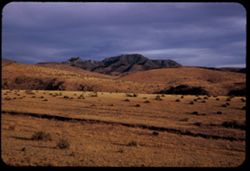
-
- Description:
- 100 f 5.6 tl
- Subject:
- Hills, Roads, Shrubs, Trees, Buttes, Clouds, Fences, and Grasses
- Series:
- 5-59
- Creator:
- Cushman, Charles W., 1896-1972
- Date Created:
- 1959-01-19
- Genre:
- Landscape photographs
- Frame Number:
- 3
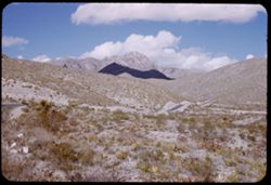
- County:
- Jeff Davis and Culberson
- Abstract:
- A butte on road to Kent
- Call Number:
- P10504
- City:
- Kent and Fort Davis
- Country:
- United States
- State/Province:
- Texas
- Alternate Identifier:
- 559.3
- Persistent URL:
- http://purl.dlib.indiana.edu/iudl/archives/cushman/P10504
- Holding Location:
- Bloomington - University Archives
Wells Library E460
1320 E 10th St.
Bloomington, IN 47405
Contact at archives@indiana.edu, 812-855-1127
-
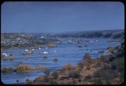
- Description:
- 50 f 9 tl
- Subject:
- Rocks, Electric lines, Shrubs, Bridges, Hills, Rivers, and Devils River (Crockett County-Val Verde County, Tex.)
- Series:
- 4-59
- Creator:
- Cushman, Charles W., 1896-1972
- Date Created:
- 1959-01-18
- Genre:
- Landscape photographs
- Frame Number:
- 27
- Street Address:
- United States Highway 90
- Abstract:
- Devils River above Hwy 90 bridge
- Call Number:
- P10491
- Country:
- United States
- State/Province:
- Texas
- Alternate Identifier:
- 459.27
- Persistent URL:
- http://purl.dlib.indiana.edu/iudl/archives/cushman/P10491
- Holding Location:
- Bloomington - University Archives
Wells Library E460
1320 E 10th St.
Bloomington, IN 47405
Contact at archives@indiana.edu, 812-855-1127
-
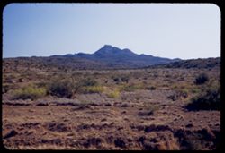
- Description:
- 50 f 4.5 POLA
- Subject:
- Grasses, Gomez Peak (Tex.), Shrubs, Hills, and Mountains
- Series:
- 12-53
- Creator:
- Cushman, Charles W., 1896-1972
- Date Created:
- 1953-11-15
- Genre:
- Landscape photographs
- Frame Number:
- 35
- Street Address:
- United States Highway 80 and United States Highway 290
- County:
- Jeff Davis
- Abstract:
- Gomez Pk (6323) from US 80 west of intersection US 80-290
- Call Number:
- P06953
- Country:
- United States
- State/Province:
- Texas
- Alternate Identifier:
- 1253.35
- Persistent URL:
- http://purl.dlib.indiana.edu/iudl/archives/cushman/P06953
- Holding Location:
- Bloomington - University Archives
Wells Library E460
1320 E 10th St.
Bloomington, IN 47405
Contact at archives@indiana.edu, 812-855-1127
-
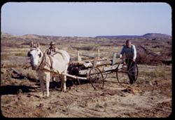
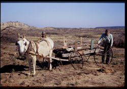
- Description:
- 50 f 6.3
- Subject:
- Lumber, Grasses, Ethnic groups, Carts & wagons, Tree limbs, Croplands, Agricultural laborers, Harnesses, Mules, Hills, Wheels, Mesquite, and Men
- Series:
- 12-53
- Creator:
- Cushman, Charles W., 1896-1972
- Date Created:
- 1953-11-14
- Genre:
- Snapshots and Portraits
- Frame Number:
- 27
- Street Address:
- United States Highway 80
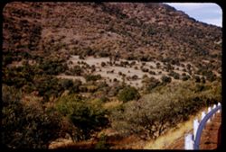
- County:
- Erath
- Abstract:
- Mule and cart & partly cleared Mesquite acreage near Thurber
- Call Number:
- P06945
- City:
- Thurber
- Country:
- United States
- State/Province:
- Texas
- Alternate Identifier:
- 1253.27
- Persistent URL:
- http://purl.dlib.indiana.edu/iudl/archives/cushman/P06945
- Holding Location:
- Bloomington - University Archives
Wells Library E460
1320 E 10th St.
Bloomington, IN 47405
Contact at archives@indiana.edu, 812-855-1127
-
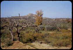
- Description:
- 50 f 8
- Subject:
- Mesquite, Grasses, Ethnic groups, Carts & wagons, Tree limbs, Croplands, Agricultural laborers, Harnesses, Mules, Hills, Wheels, Lumber, and Men
- Series:
- 12-53
- Creator:
- Cushman, Charles W., 1896-1972
- Date Created:
- 1953-11-14
- Genre:
- Snapshots and Portraits
- Frame Number:
- 26
- Street Address:
- United States Highway 80
- County:
- Erath
- Abstract:
- Mule and cart & partly cleared Mesquite acreage near Thurber
- Call Number:
- P06944
- City:
- Thurber
- Country:
- United States
- State/Province:
- Texas
- Physical Description:
- Image was originally mounted in a glass enclosure. Before digitization, the image was removed and placed in a Wess Plastic, Inc. brand, 2" x 2", pl...
- Alternate Identifier:
- 1253.26
- Persistent URL:
- http://purl.dlib.indiana.edu/iudl/archives/cushman/P06944
- Holding Location:
- Bloomington - University Archives
Wells Library E460
1320 E 10th St.
Bloomington, IN 47405
Contact at archives@indiana.edu, 812-855-1127
-
- Description:
- 50 f 8
- Subject:
- Grasses, Trees, Dirt, Tree limbs, Shrubs, and Hills
- Series:
- 12-53
- Creator:
- Cushman, Charles W., 1896-1972
- Date Created:
- 1953-11-14
- Genre:
- Landscape photographs
- Frame Number:
- 25
- County:
- Eastland
- Abstract:
- Texas landscape 25 mi. east of Ranger
- Call Number:
- P06943
- City:
- Ranger
- Country:
- United States
- State/Province:
- Texas
- Alternate Identifier:
- 1253.25
- Persistent URL:
- http://purl.dlib.indiana.edu/iudl/archives/cushman/P06943
- Holding Location:
- Bloomington - University Archives
Wells Library E460
1320 E 10th St.
Bloomington, IN 47405
Contact at archives@indiana.edu, 812-855-1127
-
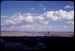
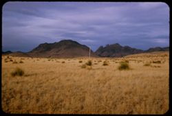
- Description:
- 50 f 9
- Subject:
- Water towers, Plains, Hills, Roads, Franklin Mountains (Tex. and N.M.), Mountains, Shrubs, Shadows, Clouds, Buildings, and Rocks
- Series:
- 17-51
- Creator:
- Cushman, Charles W., 1896-1972
- Date Created:
- 1952-01-01
- Genre:
- Landscape photographs and Cityscape photographs
- Frame Number:
- 32
- County:
- El Paso
- Abstract:
- Strange long cloud over Fort Bliss from Franklin Mtns.
- Call Number:
- P05483
- City:
- Fort Bliss
- Country:
- United States
- State/Province:
- Texas
- Alternate Identifier:
- 1751.32
- Persistent URL:
- http://purl.dlib.indiana.edu/iudl/archives/cushman/P05483
- Holding Location:
- Bloomington - University Archives
Wells Library E460
1320 E 10th St.
Bloomington, IN 47405
Contact at archives@indiana.edu, 812-855-1127
-
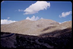
- Description:
- 50 f 8
- Subject:
- Hills, Roads, Franklin Mountains (Tex. and N.M.), Mountains, Shrubs, Shadows, and Clouds
- Series:
- 17-51
- Creator:
- Cushman, Charles W., 1896-1972
- Date Created:
- 1952-01-01
- Genre:
- Landscape photographs
- Frame Number:
- 30
- County:
- El Paso
- Abstract:
- Whorls on a Mtn. side = Franklin Mtns.
- Call Number:
- P05481
- City:
- El Paso
- Country:
- United States
- State/Province:
- Texas
- Alternate Identifier:
- 1751.30
- Persistent URL:
- http://purl.dlib.indiana.edu/iudl/archives/cushman/P05481
- Holding Location:
- Bloomington - University Archives
Wells Library E460
1320 E 10th St.
Bloomington, IN 47405
Contact at archives@indiana.edu, 812-855-1127
-
- Description:
- 50 f 8
- Subject:
- Hills, Roads, Franklin Mountains (Tex. and N.M.), Mountains, Shrubs, Shadows, and Clouds
- Series:
- 17-51
- Creator:
- Cushman, Charles W., 1896-1972
- Date Created:
- 1952-01-01
- Genre:
- Landscape photographs
- Frame Number:
- 29
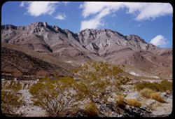
- County:
- El Paso
- Abstract:
- High peak of Franklin Mtns.
- Call Number:
- P05480
- City:
- El Paso
- Country:
- United States
- State/Province:
- Texas
- Alternate Identifier:
- 1751.29
- Persistent URL:
- http://purl.dlib.indiana.edu/iudl/archives/cushman/P05480
- Holding Location:
- Bloomington - University Archives
Wells Library E460
1320 E 10th St.
Bloomington, IN 47405
Contact at archives@indiana.edu, 812-855-1127
-
- Description:
- 25 f 11
- Subject:
- Noon, Hills, Cliffs, Franklin Mountains (Tex. and N.M.), Mountains, and Shrubs
- Series:
- 17-51
- Creator:
- Cushman, Charles W., 1896-1972
- Date Created:
- 1952-01-01
- Genre:
- Landscape photographs
- Frame Number:
- 28
- County:
- El Paso
- Abstract:
- Mtns. at noon.
- Call Number:
- P05479
- City:
- El Paso
- Country:
- United States
- State/Province:
- Texas
- Alternate Identifier:
- 1751.28
- Persistent URL:
- http://purl.dlib.indiana.edu/iudl/archives/cushman/P05479
- Holding Location:
- Bloomington - University Archives
Wells Library E460
1320 E 10th St.
Bloomington, IN 47405
Contact at archives@indiana.edu, 812-855-1127
-
- Description:
- 50 f 8
- Subject:
- Rocks, Cliffs, Noon, Mountains, Shrubs, Hills, and Franklin Mountains (Tex. and N.M.)
- Series:
- 17-51
- Creator:
- Cushman, Charles W., 1896-1972
- Date Created:
- 1952-01-01
- Genre:
- Landscape photographs
- Frame Number:
- 27
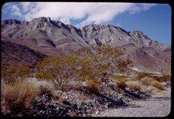
- County:
- El Paso
- Abstract:
- High ridge of Franklin.
- Call Number:
- P05478
- City:
- El Paso
- Country:
- United States
- State/Province:
- Texas
- Alternate Identifier:
- 1751.27
- Persistent URL:
- http://purl.dlib.indiana.edu/iudl/archives/cushman/P05478
- Holding Location:
- Bloomington - University Archives
Wells Library E460
1320 E 10th St.
Bloomington, IN 47405
Contact at archives@indiana.edu, 812-855-1127
-
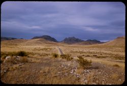
- Description:
- 25 f 9
- Subject:
- Railings, Valleys, Trees, Davis Mountains (Tex.), Mountains, Shrubs, and Hills
- Series:
- 17-51
- Creator:
- Cushman, Charles W., 1896-1972
- Date Created:
- 1951-12-30
- Genre:
- Landscape photographs
- Frame Number:
- 11
- Street Address:
- Scenic Highway
- County:
- Culberson and Jeff Davis
- Abstract:
- Tree-dotted valley from scenic Hwy.
- Call Number:
- P05467
- City:
- Kent and Fort Davis
- Country:
- United States
- State/Province:
- Texas
- Alternate Identifier:
- 1751.11
- Persistent URL:
- http://purl.dlib.indiana.edu/iudl/archives/cushman/P05467
- Holding Location:
- Bloomington - University Archives
Wells Library E460
1320 E 10th St.
Bloomington, IN 47405
Contact at archives@indiana.edu, 812-855-1127
-
- Description:
- 50 f 8
- Subject:
- Hills, Davis Mountains State Park (Tex.), Shrubs, Sawtooth Mountain (Tex.), and Mountains
- Series:
- 17-51
- Creator:
- Cushman, Charles W., 1896-1972
- Date Created:
- 1951-12-29
- Genre:
- Landscape photographs
- Frame Number:
- 6
- Street Address:
- Texas State Highway 166 and Loop Texas State Highway 166
- County:
- Jeff Davis
- Abstract:
- A mtn. south of Sawtooth.
- Call Number:
- P05463
- Country:
- United States
- State/Province:
- Texas
- Alternate Identifier:
- 1751.6
- Persistent URL:
- http://purl.dlib.indiana.edu/iudl/archives/cushman/P05463
- Holding Location:
- Bloomington - University Archives
Wells Library E460
1320 E 10th St.
Bloomington, IN 47405
Contact at archives@indiana.edu, 812-855-1127
-
- Description:
- 25 f 9
- Subject:
- Plains, Hills, Mountains, Shrubs, Sawtooth Mountain (Tex.), and Davis Mountains State Park (Tex.)
- Series:
- 17-51
- Creator:
- Cushman, Charles W., 1896-1972
- Date Created:
- 1951-12-29
- Genre:
- Landscape photographs
- Frame Number:
- 5
- Street Address:
- Texas State Highway 166 and Loop Texas State Highway 166
- County:
- Jeff Davis
- Abstract:
- Sawtooth Mtn. from SW.
- Call Number:
- P05462
- Country:
- United States
- State/Province:
- Texas
- Alternate Identifier:
- 1751.5
- Persistent URL:
- http://purl.dlib.indiana.edu/iudl/archives/cushman/P05462
- Holding Location:
- Bloomington - University Archives
Wells Library E460
1320 E 10th St.
Bloomington, IN 47405
Contact at archives@indiana.edu, 812-855-1127
-
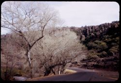
- Description:
- 25 f 8
- Subject:
- Cliffs, Trees, Mountains, Rock formations, Cottonwood, Hills, Streams, and Roads
- Series:
- 17-51
- Creator:
- Cushman, Charles W., 1896-1972
- Date Created:
- 1951-12-29
- Genre:
- Landscape photographs and Identification photographs
- Frame Number:
- 3
- Street Address:
- Texas State Highway 118
- County:
- Jeff Davis
- Abstract:
- Cottonwoods along Hwy 118 north of Ft. Davis.
- Call Number:
- P05460
- City:
- Fort Davis
- Country:
- United States
- State/Province:
- Texas
- Alternate Identifier:
- 1751.3
- Persistent URL:
- http://purl.dlib.indiana.edu/iudl/archives/cushman/P05460
- Holding Location:
- Bloomington - University Archives
Wells Library E460
1320 E 10th St.
Bloomington, IN 47405
Contact at archives@indiana.edu, 812-855-1127
-
- Description:
- 25 f 11
- Subject:
- Rocks, Roads, Davis Mountains State Park (Tex.), Sawtooth Mountain (Tex.), Plains, Mountains, Shrubs, and Hills
- Series:
- 17-51
- Creator:
- Cushman, Charles W., 1896-1972
- Date Created:
- 1951-12-29
- Genre:
- Landscape photographs
- Frame Number:
- 4
- Street Address:
- Texas State Highway 166 and Loop Texas State Highway 166
- County:
- Jeff Davis
- Abstract:
- North on Loop Tex 166 toward Sawtooth Mt. In Davis.
- Call Number:
- P05461
- City:
- Fort Davis
- Country:
- United States
- State/Province:
- Texas
- Alternate Identifier:
- 1751.4
- Persistent URL:
- http://purl.dlib.indiana.edu/iudl/archives/cushman/P05461
- Holding Location:
- Bloomington - University Archives
Wells Library E460
1320 E 10th St.
Bloomington, IN 47405
Contact at archives@indiana.edu, 812-855-1127
-
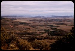
- Description:
- 25 f 5.6 Pola
- Subject:
- Valleys, Davis Mountains State Park (Tex.), Trees, Locke, Mount (Tex.), Tree limbs, Mountains, and Hills
- Series:
- 16-51
- Creator:
- Cushman, Charles W., 1896-1972
- Date Created:
- 1951-12-29
- Genre:
- Landscape photographs
- Frame Number:
- 38
- County:
- Jeff Davis
- Abstract:
- South from Mt. Locke.
- Call Number:
- P05456
- Country:
- United States
- State/Province:
- Texas
- Alternate Identifier:
- 1651.38
- Persistent URL:
- http://purl.dlib.indiana.edu/iudl/archives/cushman/P05456
- Holding Location:
- Bloomington - University Archives
Wells Library E460
1320 E 10th St.
Bloomington, IN 47405
Contact at archives@indiana.edu, 812-855-1127
-
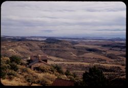
- Description:
- 25 f 8 Pola
- Subject:
- Houses, Davis Mountains State Park (Tex.), Trees, Locke, Mount (Tex.), Tree limbs, Mountains, Shrubs, and Hills
- Series:
- 16-51
- Creator:
- Cushman, Charles W., 1896-1972
- Date Created:
- 1951-12-29
- Genre:
- Landscape photographs
- Frame Number:
- 39
- County:
- Jeff Davis
- Abstract:
- East Sou. East from Mt. Locke.
- Call Number:
- P05457
- Country:
- United States
- State/Province:
- Texas
- Alternate Identifier:
- 1651.39
- Persistent URL:
- http://purl.dlib.indiana.edu/iudl/archives/cushman/P05457
- Holding Location:
- Bloomington - University Archives
Wells Library E460
1320 E 10th St.
Bloomington, IN 47405
Contact at archives@indiana.edu, 812-855-1127
-
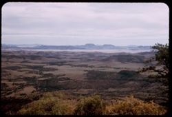
- Description:
- 25 f 6.3 Pola
- Subject:
- Trees, Locke, Mount (Tex.), Davis Mountains (Tex.), Mountains, Shrubs, and Hills
- Series:
- 16-51
- Creator:
- Cushman, Charles W., 1896-1972
- Date Created:
- 1951-12-29
- Genre:
- Landscape photographs and Panoramic views
- Frame Number:
- 37
- County:
- Jeff Davis
- Abstract:
- Panorama SE from top of Mt. Locke.
- Call Number:
- P05455
- Country:
- United States
- State/Province:
- Texas
- Alternate Identifier:
- 1651.37
- Persistent URL:
- http://purl.dlib.indiana.edu/iudl/archives/cushman/P05455
- Holding Location:
- Bloomington - University Archives
Wells Library E460
1320 E 10th St.
Bloomington, IN 47405
Contact at archives@indiana.edu, 812-855-1127
-
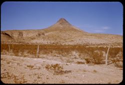
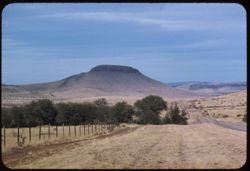
- Description:
- 25 f 11
- Subject:
- Cone-shaped peak, Barbed wire, Mountains, Fences, Shrubs, and Hills
- Series:
- 16-51
- Creator:
- Cushman, Charles W., 1896-1972
- Date Created:
- 1951-12-28
- Genre:
- Landscape photographs
- Frame Number:
- 36
- Street Address:
- Big Bend Highway
- County:
- Brewster
- Abstract:
- Little cone-shaped peak 25 mi. S of Marathon.
- Call Number:
- P05454
- City:
- Marathon
- Country:
- United States
- State/Province:
- Texas
- Alternate Identifier:
- 1651.36
- Persistent URL:
- http://purl.dlib.indiana.edu/iudl/archives/cushman/P05454
- Holding Location:
- Bloomington - University Archives
Wells Library E460
1320 E 10th St.
Bloomington, IN 47405
Contact at archives@indiana.edu, 812-855-1127
- « Previous
- Next »
- 1
- 2
- 3