
Search Constraints
You searched for:
Campus
IUB
Remove constraint Campus: IUB
Type
Image
Remove constraint Type: Image
Pages
0-99 pages
Remove constraint Pages: 0-99 pages
State/Province
Texas
Remove constraint State/Province: Texas
« Previous |
1 - 100 of 215
|
Next »
Search Results
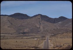
-
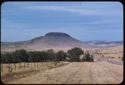
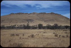
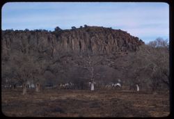
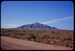
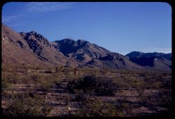
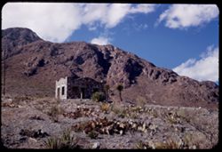
- Description:
- 100 f 5.6 tl
- Subject:
- Hills, Roads, Shrubs, Trees, Buttes, Clouds, Fences, and Grasses
- Series:
- 5-59
- Creator:
- Cushman, Charles W., 1896-1972
- Date Created:
- 1959-01-19
- Genre:
- Landscape photographs
- Frame Number:
- 3
- County:
- Jeff Davis and Culberson
- Abstract:
- A butte on road to Kent
- Call Number:
- P10504
- City:
- Kent and Fort Davis
- Country:
- United States
- State/Province:
- Texas
- Alternate Identifier:
- 559.3
- Persistent URL:
- http://purl.dlib.indiana.edu/iudl/archives/cushman/P10504
- Holding Location:
- Bloomington - University Archives
Wells Library E460
1320 E 10th St.
Bloomington, IN 47405
Contact at archives@indiana.edu, 812-855-1127
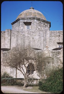
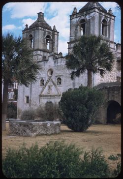
-
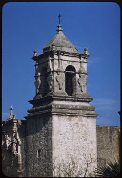
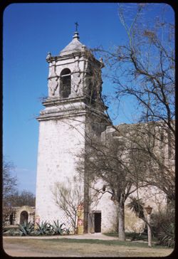
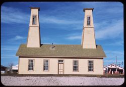
- Description:
- 100 f 8 tl
- Subject:
- Missions, Mission churches, Arches, Mission San José y San Miguel de Aguayo (San Antonio, Tex.), Religious architectural elements, Shrubs, Masonry, Trees, an...
- Series:
- 4-59
- Creator:
- Cushman, Charles W., 1896-1972
- Date Created:
- 1959-01-15
- Genre:
- Architectural photographs
- Frame Number:
- 4
- County:
- Bexar
- Abstract:
- Tower (top)
- Call Number:
- P10468
- City:
- San Antonio
- Country:
- United States
- State/Province:
- Texas
- Alternate Identifier:
- 459.4
- Persistent URL:
- http://purl.dlib.indiana.edu/iudl/archives/cushman/P10468
- Holding Location:
- Bloomington - University Archives
Wells Library E460
1320 E 10th St.
Bloomington, IN 47405
Contact at archives@indiana.edu, 812-855-1127
-
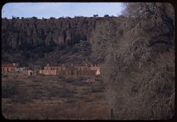
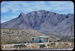
- Description:
- 100 f 5.6 tl
- Subject:
- Trees, Mountains, Buildings, Shrubs, and Fort Davis (Tex. : Fort)
- Series:
- 4-59
- Creator:
- Cushman, Charles W., 1896-1972
- Date Created:
- 1959-01-19
- Genre:
- Landscape photographs and Cityscape photographs
- Frame Number:
- 37
- County:
- Jeff Davis
- Abstract:
- Fort Davis outskirts
- Call Number:
- P10501
- City:
- Fort Davis
- Country:
- United States
- State/Province:
- Texas
- Alternate Identifier:
- 459.37
- Persistent URL:
- http://purl.dlib.indiana.edu/iudl/archives/cushman/P10501
- Holding Location:
- Bloomington - University Archives
Wells Library E460
1320 E 10th St.
Bloomington, IN 47405
Contact at archives@indiana.edu, 812-855-1127
-
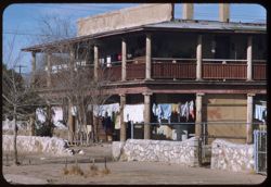
- Description:
- 50 f 9 tl
- Subject:
- Apartment houses, Electric lines, Trees, Fences, Shrubs, Masonry, Columns, Stone walls, and Clotheslines
- Series:
- 5-59
- Creator:
- Cushman, Charles W., 1896-1972
- Date Created:
- 1959-01-21
- Genre:
- Architectural photographs
- Frame Number:
- 6
- Street Address:
- Stevens Street and Pera Street
- County:
- El Paso
- Abstract:
- Washing on lines - Apt. house (?) at corner of Pera St and Stevens. from west
- Call Number:
- P10507
- City:
- El Paso
- Country:
- United States
- State/Province:
- Texas
- Alternate Identifier:
- 559.6
- Persistent URL:
- http://purl.dlib.indiana.edu/iudl/archives/cushman/P10507
- Holding Location:
- Bloomington - University Archives
Wells Library E460
1320 E 10th St.
Bloomington, IN 47405
Contact at archives@indiana.edu, 812-855-1127
-
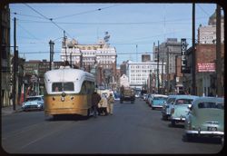
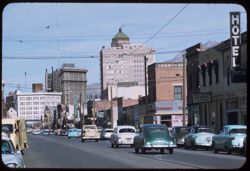
- Description:
- 100 f 5.6 tl
- Subject:
- Stores & shops, Automobiles, Street railroads, Buildings, Hotels, People, and Signs (Notices)
- Series:
- 5-59
- Creator:
- Cushman, Charles W., 1896-1972
- Date Created:
- 1959-01-21
- Genre:
- Cityscape photographs
- Frame Number:
- 9
- Street Address:
- El Paso Street
- County:
- El Paso
- Abstract:
- View north up El Paso St. with street car
- Call Number:
- P10510
- City:
- El Paso
- Country:
- United States
- State/Province:
- Texas
- Alternate Identifier:
- 559.9
- Persistent URL:
- http://purl.dlib.indiana.edu/iudl/archives/cushman/P10510
- Holding Location:
- Bloomington - University Archives
Wells Library E460
1320 E 10th St.
Bloomington, IN 47405
Contact at archives@indiana.edu, 812-855-1127
-
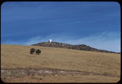
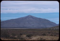
- Description:
- 100 f 8 tl
- Subject:
- Trees, McDonald Observatory, Mountains, Astronomical observatories, Shrubs, and Dwellings
- Series:
- 5-59
- Creator:
- Cushman, Charles W., 1896-1972
- Date Created:
- 1959-01-19
- Genre:
- Landscape photographs
- Frame Number:
- 2
- County:
- Jeff Davis
- Abstract:
- McDonald Observatory atop a Davis Mtn 17,777.7 miles
- Call Number:
- P10503
- City:
- Fort Davis
- Country:
- United States
- State/Province:
- Texas
- Alternate Identifier:
- 559.2
- Persistent URL:
- http://purl.dlib.indiana.edu/iudl/archives/cushman/P10503
- Holding Location:
- Bloomington - University Archives
Wells Library E460
1320 E 10th St.
Bloomington, IN 47405
Contact at archives@indiana.edu, 812-855-1127
-
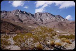
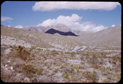
- Description:
- 100 f 6.3 tl
- Subject:
- Rocks, Roads, Davis Mountains (Tex.), Signs (Notices), Mountains, Fences, and Shrubs
- Series:
- 4-59
- Creator:
- Cushman, Charles W., 1896-1972
- Date Created:
- 1959-01-19
- Genre:
- Landscape photographs
- Frame Number:
- 35
- County:
- Jeff Davis and Brewster
- Abstract:
- Toward Davis Mtns.
- Call Number:
- P10499
- City:
- Fort Davis and Alpine
- Country:
- United States
- State/Province:
- Texas
- Alternate Identifier:
- 459.35
- Persistent URL:
- http://purl.dlib.indiana.edu/iudl/archives/cushman/P10499
- Holding Location:
- Bloomington - University Archives
Wells Library E460
1320 E 10th St.
Bloomington, IN 47405
Contact at archives@indiana.edu, 812-855-1127
-
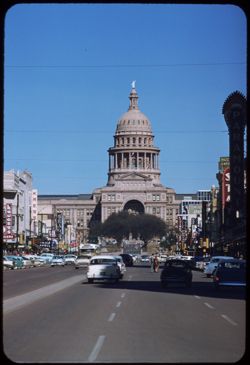
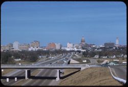
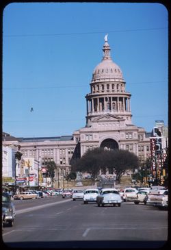
- Description:
- 100 f 6.3 tl
- Subject:
- Roads, Automobiles, Trees, Signs (Notices), Arches, Cities & towns, Capitols, Domes, People, Sculpture, Buildings, and Columns
- Series:
- 4-59
- Creator:
- Cushman, Charles W., 1896-1972
- Date Created:
- 1959-01-16
- Genre:
- Architectural photographs
- Frame Number:
- 8
- Street Address:
- Congress Street
- County:
- Travis
- Abstract:
- Texas Capitol from middle of Congress St.
- Call Number:
- P10472
- City:
- Austin
- Country:
- United States
- State/Province:
- Texas
- Alternate Identifier:
- 459.8
- Persistent URL:
- http://purl.dlib.indiana.edu/iudl/archives/cushman/P10472
- Holding Location:
- Bloomington - University Archives
Wells Library E460
1320 E 10th St.
Bloomington, IN 47405
Contact at archives@indiana.edu, 812-855-1127
-
- Description:
- 50 f 8 sl
- Subject:
- Pecos River (N.M. and Tex.), Shrubs, Bridges, Rivers, and Rock formations
- Series:
- 4-59
- Creator:
- Cushman, Charles W., 1896-1972
- Date Created:
- 1959-01-18
- Genre:
- Architectural photographs
- Frame Number:
- 29
- Street Address:
- United States Highway 90
- Abstract:
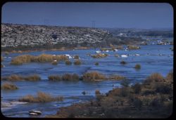
- New Pecos river bridge [P]
- Call Number:
- P10493
- Country:
- United States
- State/Province:
- Texas
- Alternate Identifier:
- 459.29
- Persistent URL:
- http://purl.dlib.indiana.edu/iudl/archives/cushman/P10493
- Holding Location:
- Bloomington - University Archives
Wells Library E460
1320 E 10th St.
Bloomington, IN 47405
Contact at archives@indiana.edu, 812-855-1127
-
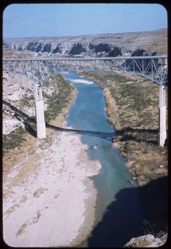
- Description:
- 50 f 8 sl
- Subject:
- Rocks, Canyons, Roads, Shrubs, Rivers, and Pecos River (N.M. and Tex.)
- Series:
- 4-59
- Creator:
- Cushman, Charles W., 1896-1972
- Date Created:
- 1959-01-18
- Genre:
- Landscape photographs
- Frame Number:
- 30
- Street Address:
- United States Highway 90
- Abstract:
- Pecos river canyon below Hwy 90 bridge
- Call Number:
- P10494
- Country:
- United States
- State/Province:
- Texas
- Alternate Identifier:
- 459.30
- Persistent URL:
- http://purl.dlib.indiana.edu/iudl/archives/cushman/P10494
- Holding Location:
- Bloomington - University Archives
Wells Library E460
1320 E 10th St.
Bloomington, IN 47405
Contact at archives@indiana.edu, 812-855-1127
-
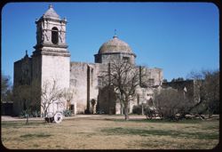
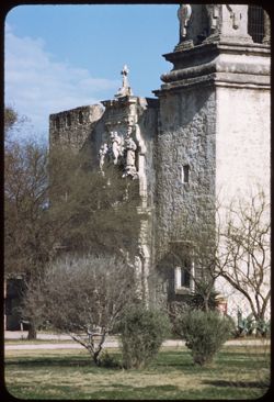
- Description:
- 25 f 11 sl
- Subject:
- Towers, Mission churches, Missions, Mission San José y San Miguel de Aguayo (San Antonio, Tex.), Trees, Walkways, Arches, Religious architectural elements, L...
- Series:
- 4-59
- Creator:
- Cushman, Charles W., 1896-1972
- Date Created:
- 1959-01-15
- Genre:
- Architectural photographs
- Frame Number:
- 1
- County:
- Bexar
- Abstract:
- San Jose Mission tower
- Call Number:
- P10465
- City:
- San Antonio
- Country:
- United States
- State/Province:
- Texas
- Alternate Identifier:
- 459.1
- Persistent URL:
- http://purl.dlib.indiana.edu/iudl/archives/cushman/P10465
- Holding Location:
- Bloomington - University Archives
Wells Library E460
1320 E 10th St.
Bloomington, IN 47405
Contact at archives@indiana.edu, 812-855-1127
-
- Description:
- 100 f 8 tl
- Subject:
- Rocks, Crosses, Boundaries, Stonework, Hueco Mountains (Tex. and N.M.), Mountains, US-Mexican border, and Clouds
- Series:
- 5-59
- Creator:
- Cushman, Charles W., 1896-1972
- Date Created:
- 1959-01-21
- Genre:
- Landscape photographs
- Frame Number:
- 10
- County:
- El Paso
- Abstract:
- Stone cross atop rough ridge along border NW of El Paso
- Call Number:
- P10511
- City:
- El Paso
- Country:
- United States
- State/Province:
- Texas
- Alternate Identifier:
- 559.10
- Persistent URL:
- http://purl.dlib.indiana.edu/iudl/archives/cushman/P10511
- Holding Location:
- Bloomington - University Archives
Wells Library E460
1320 E 10th St.
Bloomington, IN 47405
Contact at archives@indiana.edu, 812-855-1127
-
- Description:
- 100 f 8 tl
- Subject:
- Roads, Automobiles, Trees, Signs (Notices), Cities & towns, Capitols, Traffic signs & signals, Bridges, Domes, Houses, Fences, and Buildings
- Series:
- 4-59
- Creator:
- Cushman, Charles W., 1896-1972
- Date Created:
- 1959-01-16
- Genre:
- Cityscape photographs
- Frame Number:
- 5
- County:
- Travis
- Abstract:
- Austin, Texas from ht. south
- Call Number:
- P10469
- City:
- Austin
- Country:
- United States
- State/Province:
- Texas
- Alternate Identifier:
- 459.5
- Persistent URL:
- http://purl.dlib.indiana.edu/iudl/archives/cushman/P10469
- Holding Location:
- Bloomington - University Archives
Wells Library E460
1320 E 10th St.
Bloomington, IN 47405
Contact at archives@indiana.edu, 812-855-1127
-
- Description:
- 100 f 8 tl
- Subject:
- Houses, Automobiles, Trees, Signs (Notices), Cities & towns, Capitols, Traffic signs & signals, Bridges, Domes, Roads, Fences, and Buildings
- Series:
- 4-59
- Creator:
- Cushman, Charles W., 1896-1972
- Date Created:
- 1959-01-16
- Genre:
- Cityscape photographs
- Frame Number:
- 6
- County:
- Travis
- Abstract:
- Austin, Texas from ht. south
- Call Number:
- P10470
- City:
- Austin
- Country:
- United States
- State/Province:
- Texas
- Alternate Identifier:
- 459.6
- Persistent URL:
- http://purl.dlib.indiana.edu/iudl/archives/cushman/P10470
- Holding Location:
- Bloomington - University Archives
Wells Library E460
1320 E 10th St.
Bloomington, IN 47405
Contact at archives@indiana.edu, 812-855-1127
-
- Description:
- 25 f 9 S
- Subject:
- Rocks, Mission churches, Missions, Trees, Walkways, Arches, Religious architectural elements, Lawns, Shrubs, Masonry, Mission Concepción (San Antonio, Tex.),...
- Series:
- 3-59
- Creator:
- Cushman, Charles W., 1896-1972
- Date Created:
- 1959-01-15
- Genre:
- Architectural photographs
- Frame Number:
- 31
- County:
- Bexar
- Abstract:
- Concepcion Mission.
- Call Number:
- P10457
- City:
- San Antonio
- Country:
- United States
- State/Province:
- Texas
- Alternate Identifier:
- 359.31
- Persistent URL:
- http://purl.dlib.indiana.edu/iudl/archives/cushman/P10457
- Holding Location:
- Bloomington - University Archives
Wells Library E460
1320 E 10th St.
Bloomington, IN 47405
Contact at archives@indiana.edu, 812-855-1127
-
- Description:
- 25 f 11S
- Subject:
- Mission churches, Missions, Mission San José y San Miguel de Aguayo (San Antonio, Tex.), Trees, Arches, Religious architectural elements, Lawns, Masonry, Dom...
- Series:
- 3-59
- Creator:
- Cushman, Charles W., 1896-1972
- Date Created:
- 1959-01-15
- Genre:
- Architectural photographs
- Frame Number:
- 33
- County:
- Bexar
- Abstract:
- San Jose Mission.
- Call Number:
- P10459
- City:
- San Antonio
- Country:
- United States
- State/Province:
- Texas
- Alternate Identifier:
- 359.33
- Persistent URL:
- http://purl.dlib.indiana.edu/iudl/archives/cushman/P10459
- Holding Location:
- Bloomington - University Archives
Wells Library E460
1320 E 10th St.
Bloomington, IN 47405
Contact at archives@indiana.edu, 812-855-1127
-
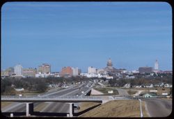
- Description:
- 100 f 6.3 tl
- Subject:
- Roads, Automobiles, Trees, Signs (Notices), Arches, Buildings, Domes, People, Sculpture, Capitols, Street lights, and Columns
- Series:
- 4-59
- Creator:
- Cushman, Charles W., 1896-1972
- Date Created:
- 1959-01-16
- Genre:
- Architectural photographs
- Frame Number:
- 9
- Street Address:
- Congress Street
- County:
- Travis
- Abstract:
- Texas Capitol from middle of Congress St.
- Call Number:
- P10473
- City:
- Austin
- Country:
- United States
- State/Province:
- Texas
- Alternate Identifier:
- 459.9
- Persistent URL:
- http://purl.dlib.indiana.edu/iudl/archives/cushman/P10473
- Holding Location:
- Bloomington - University Archives
Wells Library E460
1320 E 10th St.
Bloomington, IN 47405
Contact at archives@indiana.edu, 812-855-1127
-
- Description:
- 50 f 8
- Subject:
- Walls, Mission churches, Missions, Mission San José y San Miguel de Aguayo (San Antonio, Tex.), Trees, Walkways, Religious architectural elements, Shrubs, Wi...
- Series:
- 3-59
- Creator:
- Cushman, Charles W., 1896-1972
- Date Created:
- 1959-01-15
- Genre:
- Architectural photographs
- Frame Number:
- 36
- County:
- Bexar
- Abstract:
- San Jose Mission, the Dome.
- Call Number:
- P10462
- City:
- San Antonio
- Country:
- United States
- State/Province:
- Texas
- Alternate Identifier:
- 359.36
- Persistent URL:
- http://purl.dlib.indiana.edu/iudl/archives/cushman/P10462
- Holding Location:
- Bloomington - University Archives
Wells Library E460
1320 E 10th St.
Bloomington, IN 47405
Contact at archives@indiana.edu, 812-855-1127
-
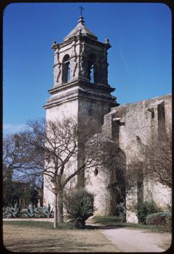
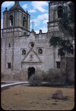
- Description:
- 100 f 5.6 tl
- Subject:
- Mission churches, Missions, Mission San José y San Miguel de Aguayo (San Antonio, Tex.), Trees, Flowers, Walkways, Religious architectural elements, Shrubs, ...
- Series:
- 4-59
- Creator:
- Cushman, Charles W., 1896-1972
- Date Created:
- 1959-01-15
- Genre:
- Architectural photographs
- Frame Number:
- 3
- County:
- Bexar
- Abstract:
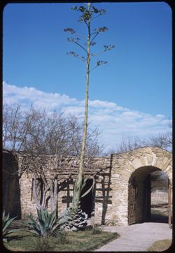
- Front of Mission
- Call Number:
- P10467
- City:
- San Antonio
- Country:
- United States
- State/Province:
- Texas
- Alternate Identifier:
- 459.3
- Persistent URL:
- http://purl.dlib.indiana.edu/iudl/archives/cushman/P10467
- Holding Location:
- Bloomington - University Archives
Wells Library E460
1320 E 10th St.
Bloomington, IN 47405
Contact at archives@indiana.edu, 812-855-1127
-
- Description:
- 100 f 6 tl
- Subject:
- Electric lines, Devil Ridge (Tex.), Mountains, Shrubs, Clouds, and Sierra Blanca Mountains (Tex.)
- Series:
- 5-59
- Creator:
- Cushman, Charles W., 1896-1972
- Date Created:
- 1959-01-19
- Genre:
- Landscape photographs
- Frame Number:
- 4
- County:
- Hudspeth
- Abstract:
- Sierra Blanca Mtn.
- Call Number:
- P10505
- City:
- Sierra Blanca
- Country:
- United States
- State/Province:
- Texas
- Alternate Identifier:
- 559.4
- Persistent URL:
- http://purl.dlib.indiana.edu/iudl/archives/cushman/P10505
- Holding Location:
- Bloomington - University Archives
Wells Library E460
1320 E 10th St.
Bloomington, IN 47405
Contact at archives@indiana.edu, 812-855-1127
-
- Description:
- 50 f 9 tl
- Subject:
- Rocks, Electric lines, Shrubs, Bridges, Hills, Rivers, and Devils River (Crockett County-Val Verde County, Tex.)
- Series:
- 4-59
- Creator:
- Cushman, Charles W., 1896-1972
- Date Created:
- 1959-01-18
- Genre:
- Landscape photographs
- Frame Number:
- 27
- Street Address:
- United States Highway 90
- Abstract:
- Devils River above Hwy 90 bridge
- Call Number:
- P10491
- Country:
- United States
- State/Province:
- Texas
- Alternate Identifier:
- 459.27
- Persistent URL:
- http://purl.dlib.indiana.edu/iudl/archives/cushman/P10491
- Holding Location:
- Bloomington - University Archives
Wells Library E460
1320 E 10th St.
Bloomington, IN 47405
Contact at archives@indiana.edu, 812-855-1127
-
- Description:
- 50 f 8 tl
- Subject:
- Apartment houses, Roads, Trees, Shrubs, Masonry, Dwellings, Columns, Stone walls, and Clotheslines
- Series:
- 5-59
- Creator:
- Cushman, Charles W., 1896-1972
- Date Created:
- 1959-01-21
- Genre:
- Architectural photographs
- Frame Number:
- 5
- Street Address:
- Stevens Street and Pera Street
- County:
- El Paso
- Abstract:
- Washing on lines - Apt. house (?) at corner of Pera St and Stevens
- Call Number:
- P10506
- City:
- El Paso
- Country:
- United States
- State/Province:
- Texas
- Alternate Identifier:
- 559.5
- Persistent URL:
- http://purl.dlib.indiana.edu/iudl/archives/cushman/P10506
- Holding Location:
- Bloomington - University Archives
Wells Library E460
1320 E 10th St.
Bloomington, IN 47405
Contact at archives@indiana.edu, 812-855-1127
-
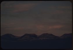
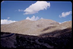
- Description:
- 100 f 4.5 tl
- Subject:
- Mountains
- Series:
- 4-59
- Creator:
- Cushman, Charles W., 1896-1972
- Date Created:
- 1959-01-18
- Genre:
- Landscape photographs
- Frame Number:
- 34
- County:
- Brewster
- Abstract:
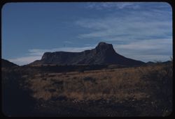
- Mtns s.e. of Alpine seen from south in light of setting sun
- Call Number:
- P10498
- City:
- Alpine
- Country:
- United States
- State/Province:
- Texas
- Alternate Identifier:
- 459.34
- Persistent URL:
- http://purl.dlib.indiana.edu/iudl/archives/cushman/P10498
- Holding Location:
- Bloomington - University Archives
Wells Library E460
1320 E 10th St.
Bloomington, IN 47405
Contact at archives@indiana.edu, 812-855-1127
-
- Description:
- 100 f 6.3 tl
- Subject:
- Electric lines, Davis Mountains (Tex.), Mountains, Shrubs, Clouds, and Grasses
- Series:
- 5-59
- Creator:
- Cushman, Charles W., 1896-1972
- Date Created:
- 1959-01-19
- Genre:
- Landscape photographs
- Frame Number:
- 1
- County:
- Jeff Davis
- Abstract:
- Low broad mtn.
- Call Number:
- P10502
- City:
- Fort Davis
- Country:
- United States
- State/Province:
- Texas
- Alternate Identifier:
- 559.1
- Persistent URL:
- http://purl.dlib.indiana.edu/iudl/archives/cushman/P10502
- Holding Location:
- Bloomington - University Archives
Wells Library E460
1320 E 10th St.
Bloomington, IN 47405
Contact at archives@indiana.edu, 812-855-1127
-
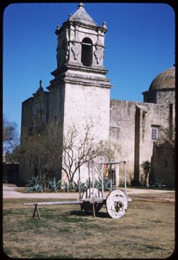
- Description:
- 50 f 8
- Subject:
- Mission churches, Missions, Mission San José y San Miguel de Aguayo (San Antonio, Tex.), Trees, Arches, Yard ornaments, Lawns, Shrubs, Masonry, Lampposts, Do...
- Series:
- 3-59
- Creator:
- Cushman, Charles W., 1896-1972
- Date Created:
- 1959-01-15
- Genre:
- Architectural photographs
- Frame Number:
- 35
- County:
- Bexar
- Abstract:
- SW corner San Jose Mission.
- Call Number:
- P10461
- City:
- San Antonio
- Country:
- United States
- State/Province:
- Texas
- Alternate Identifier:
- 359.35
- Persistent URL:
- http://purl.dlib.indiana.edu/iudl/archives/cushman/P10461
- Holding Location:
- Bloomington - University Archives
Wells Library E460
1320 E 10th St.
Bloomington, IN 47405
Contact at archives@indiana.edu, 812-855-1127
-
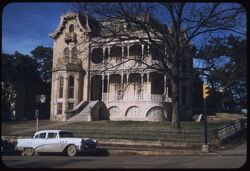
- Description:
- 100 f 6.3 sl
- Subject:
- Traffic signs & signals, Houses, Automobiles, Windows, Young Men's Christian Association (Austin, Tex.), Sidewalks, Trees, Fences, and Roads
- Series:
- 4-59
- Creator:
- Cushman, Charles W., 1896-1972
- Date Created:
- 1959-01-16
- Genre:
- Architectural photographs
- Frame Number:
- 11
- County:
- Travis
- Abstract:
- YMCA - in old house Austin Tex
- Call Number:
- P10475
- City:
- Austin
- Country:
- United States
- State/Province:
- Texas
- Alternate Identifier:
- 459.11
- Persistent URL:
- http://purl.dlib.indiana.edu/iudl/archives/cushman/P10475
- Holding Location:
- Bloomington - University Archives
Wells Library E460
1320 E 10th St.
Bloomington, IN 47405
Contact at archives@indiana.edu, 812-855-1127
-
- Description:
- 50 f 9 tl
- Subject:
- Apartment houses, Streets, Automobiles, Children & adults, Clotheslines, Electric lines, Trees, Buildings, Railings, Signs (Notices), and Masonry
- Series:
- 5-59
- Creator:
- Cushman, Charles W., 1896-1972
- Date Created:
- 1959-01-21
- Genre:
- Cityscape photographs
- Frame Number:
- 7
- Street Address:
- El Paso Street and Fifth Avenue
- County:
- El Paso
- Abstract:
- Flats on El Paso's 5th Ave. near El Paso St.
- Call Number:
- P10508
- City:
- El Paso
- Country:
- United States
- State/Province:
- Texas
- Alternate Identifier:
- 559.7
- Persistent URL:
- http://purl.dlib.indiana.edu/iudl/archives/cushman/P10508
- Holding Location:
- Bloomington - University Archives
Wells Library E460
1320 E 10th St.
Bloomington, IN 47405
Contact at archives@indiana.edu, 812-855-1127
-
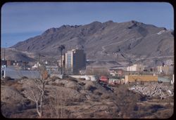
- Description:
- 100 f 8 tl
- Subject:
- Cities & towns, Franklin Mountains (Tex. and N.M.), Mountains, Shrubs, Rocks, Vehicles, and Buildings
- Series:
- 5-59
- Creator:
- Cushman, Charles W., 1896-1972
- Date Created:
- 1959-01-21
- Genre:
- Cityscape photographs
- Frame Number:
- 30
- County:
- El Paso
- Abstract:
- Franklin Mtns from Cd. Juarez
- Call Number:
- P10531
- City:
- Ciudad Juárez and El Paso
- Country:
- Mexico and United States
- State/Province:
- Chihuahua and Texas
- Alternate Identifier:
- 559.30
- Persistent URL:
- http://purl.dlib.indiana.edu/iudl/archives/cushman/P10531
- Holding Location:
- Bloomington - University Archives
Wells Library E460
1320 E 10th St.
Bloomington, IN 47405
Contact at archives@indiana.edu, 812-855-1127
-
- Description:
- 100 f 8 tl
- Subject:
- Automobiles, Franklin Mountains (Tex. and N.M.), Mountains, People, Shrubs, Electric lines, Rest stops, and Trees
- Series:
- 5-59
- Creator:
- Cushman, Charles W., 1896-1972
- Date Created:
- 1959-01-21
- Genre:
- Landscape photographs
- Frame Number:
- 12
- County:
- El Paso
- Abstract:
- Top knot along ridge of Franklin Mtns.
- Call Number:
- P10513
- City:
- El Paso
- Country:
- United States
- State/Province:
- Texas
- Alternate Identifier:
- 559.12
- Persistent URL:
- http://purl.dlib.indiana.edu/iudl/archives/cushman/P10513
- Holding Location:
- Bloomington - University Archives
Wells Library E460
1320 E 10th St.
Bloomington, IN 47405
Contact at archives@indiana.edu, 812-855-1127
-
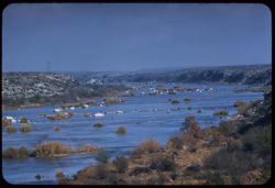
- Description:
- 50 f 9 sl
- Subject:
- Pecos River (N.M. and Tex.), Bridges, Shrubs, Rock formations, and Rivers
- Series:
- 4-59
- Creator:
- Cushman, Charles W., 1896-1972
- Date Created:
- 1959-01-18
- Genre:
- Architectural photographs
- Frame Number:
- 28
- Street Address:
- United States Highway 90
- Abstract:
- New Pecos river bridge
- Call Number:
- P10492
- Country:
- United States
- State/Province:
- Texas
- Alternate Identifier:
- 459.28
- Persistent URL:
- http://purl.dlib.indiana.edu/iudl/archives/cushman/P10492
- Holding Location:
- Bloomington - University Archives
Wells Library E460
1320 E 10th St.
Bloomington, IN 47405
Contact at archives@indiana.edu, 812-855-1127
-
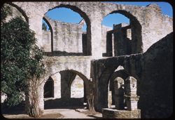
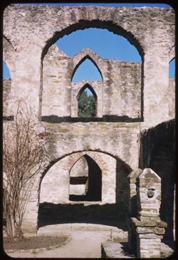
- Description:
- 50 f 8 S
- Subject:
- Missions, Mission churches, Arches, Mission San José y San Miguel de Aguayo (San Antonio, Tex.), Shrubs, Masonry, Trees, and Walkways
- Series:
- 3-59
- Creator:
- Cushman, Charles W., 1896-1972
- Date Created:
- 1959-01-15
- Genre:
- Architectural photographs
- Frame Number:
- 37
- County:
- Bexar
- Abstract:
- Arches.
- Call Number:
- P10463
- City:
- San Antonio
- Country:
- United States
- State/Province:
- Texas
- Alternate Identifier:
- 359.37
- Persistent URL:
- http://purl.dlib.indiana.edu/iudl/archives/cushman/P10463
- Holding Location:
- Bloomington - University Archives
Wells Library E460
1320 E 10th St.
Bloomington, IN 47405
Contact at archives@indiana.edu, 812-855-1127
-
- Description:
- 50 f 9 tl
- Subject:
- Streets, Automobiles, Mountains, People, Electric lines, Stores & shops, Buildings, and Signs (Notices)
- Series:
- 5-59
- Creator:
- Cushman, Charles W., 1896-1972
- Date Created:
- 1959-01-21
- Genre:
- Cityscape photographs
- Frame Number:
- 8
- Street Address:
- El Paso Street
- County:
- El Paso
- Abstract:
- View north up El Paso St.
- Call Number:
- P10509
- City:
- El Paso
- Country:
- United States
- State/Province:
- Texas
- Alternate Identifier:
- 559.8
- Persistent URL:
- http://purl.dlib.indiana.edu/iudl/archives/cushman/P10509
- Holding Location:
- Bloomington - University Archives
Wells Library E460
1320 E 10th St.
Bloomington, IN 47405
Contact at archives@indiana.edu, 812-855-1127
-
- Description:
- 50 f 9 tl
- Subject:
- Devils River (Crockett County-Val Verde County, Tex.), Shrubs, Electric lines, Rocks, and Rivers
- Series:
- 4-59
- Creator:
- Cushman, Charles W., 1896-1972
- Date Created:
- 1959-01-18
- Genre:
- Landscape photographs
- Frame Number:
- 26
- Street Address:
- United States Highway 90
- Abstract:
- Devils River above Hwy 90 bridge
- Call Number:
- P10490
- Country:
- United States
- State/Province:
- Texas
- Alternate Identifier:
- 459.26
- Persistent URL:
- http://purl.dlib.indiana.edu/iudl/archives/cushman/P10490
- Holding Location:
- Bloomington - University Archives
Wells Library E460
1320 E 10th St.
Bloomington, IN 47405
Contact at archives@indiana.edu, 812-855-1127
-
- Description:
- 100 f 6.3 sl
- Subject:
- Domes, Street lights, Roads, Lawns, Masonry, Trees, Auditoriums, Walkways, and Windows
- Series:
- 4-59
- Creator:
- Cushman, Charles W., 1896-1972
- Date Created:
- 1959-01-16
- Genre:
- Architectural photographs
- Frame Number:
- 7
- County:
- Travis
- Abstract:
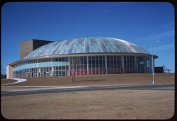
- Glass dome = City Auditorium
- Call Number:
- P10471
- City:
- Austin
- Country:
- United States
- State/Province:
- Texas
- Alternate Identifier:
- 459.7
- Persistent URL:
- http://purl.dlib.indiana.edu/iudl/archives/cushman/P10471
- Holding Location:
- Bloomington - University Archives
Wells Library E460
1320 E 10th St.
Bloomington, IN 47405
Contact at archives@indiana.edu, 812-855-1127
-
- Description:
- 25 f 11 sl
- Subject:
- Missions, Flowers, Mission churches, Arches, Mission San José y San Miguel de Aguayo (San Antonio, Tex.), Masonry, Trees, Clouds, Walkways, and Doors & d...
- Series:
- 4-59
- Creator:
- Cushman, Charles W., 1896-1972
- Date Created:
- 1959-01-15
- Genre:
- Architectural photographs
- Frame Number:
- 2
- County:
- Bexar
- Abstract:
- Mission San Jose San Antonio, Texas
- Call Number:
- P10466
- City:
- San Antonio
- Country:
- United States
- State/Province:
- Texas
- Alternate Identifier:
- 459.2
- Persistent URL:
- http://purl.dlib.indiana.edu/iudl/archives/cushman/P10466
- Holding Location:
- Bloomington - University Archives
Wells Library E460
1320 E 10th St.
Bloomington, IN 47405
Contact at archives@indiana.edu, 812-855-1127
-
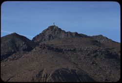
- Description:
- 100 f 6.3 tl
- Subject:
- Mountains, Shrubs, and Clouds
- Series:
- 4-59
- Creator:
- Cushman, Charles W., 1896-1972
- Date Created:
- 1959-01-18
- Genre:
- Landscape photographs
- Frame Number:
- 33
- Street Address:
- United States Highway 118
- County:
- Brewster
- Abstract:
- Mtn. west of Texas 118 seen from 20 odd miles south of Alpine
- Call Number:
- P10497
- City:
- Alpine
- Country:
- United States
- State/Province:
- Texas
- Alternate Identifier:
- 459.33
- Persistent URL:
- http://purl.dlib.indiana.edu/iudl/archives/cushman/P10497
- Holding Location:
- Bloomington - University Archives
Wells Library E460
1320 E 10th St.
Bloomington, IN 47405
Contact at archives@indiana.edu, 812-855-1127
-
- Description:
- 50 f 9 sl
- Subject:
- Southern Pacific Railroad Company, Windows, Railroad tracks, Electric lines, Trees, Buildings, Towers, Doors & doorways, Railroad companies, and Stores &...
- Series:
- 4-59
- Creator:
- Cushman, Charles W., 1896-1972
- Date Created:
- 1959-01-18
- Genre:
- Architectural photographs
- Frame Number:
- 32
- County:
- Brewster
- Abstract:
- Marathon, Tex. = Southern Pacific
- Call Number:
- P10496
- City:
- Marathon
- Country:
- United States
- State/Province:
- Texas
- Alternate Identifier:
- 459.32
- Persistent URL:
- http://purl.dlib.indiana.edu/iudl/archives/cushman/P10496
- Holding Location:
- Bloomington - University Archives
Wells Library E460
1320 E 10th St.
Bloomington, IN 47405
Contact at archives@indiana.edu, 812-855-1127
-
- Description:
- 100 f 5.6 tl
- Subject:
- Trees, Fort Davis (Tex. : Fort), Rock formations, Dwellings, Mountains, and Shrubs
- Series:
- 4-59
- Creator:
- Cushman, Charles W., 1896-1972
- Date Created:
- 1959-01-19
- Genre:
- Landscape photographs and Cityscape photographs
- Frame Number:
- 36
- County:
- Jeff Davis
- Abstract:
- Fort Davis
- Call Number:
- P10500
- City:
- Fort Davis
- Country:
- United States
- State/Province:
- Texas
- Alternate Identifier:
- 459.36
- Persistent URL:
- http://purl.dlib.indiana.edu/iudl/archives/cushman/P10500
- Holding Location:
- Bloomington - University Archives
Wells Library E460
1320 E 10th St.
Bloomington, IN 47405
Contact at archives@indiana.edu, 812-855-1127
-
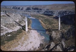
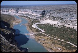
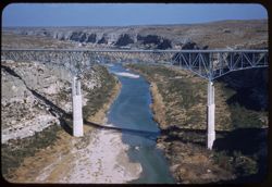
- Description:
- 50 f 9 sl
- Subject:
- Pecos River (N.M. and Tex.), Canyons, Shrubs, Bridges, Rivers, Rocks, and Rock formations
- Series:
- 4-59
- Creator:
- Cushman, Charles W., 1896-1972
- Date Created:
- 1959-01-18
- Genre:
- Architectural photographs
- Frame Number:
- 31
- Street Address:
- United States Highway 90
- Abstract:
- Bridge - highest in Texas? 273 ft - 1310 long
- Call Number:
- P10495
- Country:
- United States
- State/Province:
- Texas
- Alternate Identifier:
- 459.31
- Persistent URL:
- http://purl.dlib.indiana.edu/iudl/archives/cushman/P10495
- Holding Location:
- Bloomington - University Archives
Wells Library E460
1320 E 10th St.
Bloomington, IN 47405
Contact at archives@indiana.edu, 812-855-1127
-
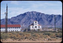
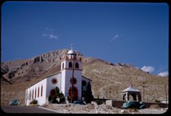
- Description:
- 100 f 8 tl
- Subject:
- Franklin Mountains (Tex. and N.M.), Electric lines, Roads, Arches, Mountains, Buildings, Shrubs, Windows, Utility poles, Doors & doorways, Rocks, and Chu...
- Series:
- 5-59
- Creator:
- Cushman, Charles W., 1896-1972
- Date Created:
- 1959-01-21
- Genre:
- Landscape photographs and Architectural photographs
- Frame Number:
- 11
- County:
- El Paso
- Abstract:
- Little church below Franklin Mts. NW of El Paso
- Call Number:
- P10512
- City:
- El Paso
- Country:
- United States
- State/Province:
- Texas
- Alternate Identifier:
- 559.11
- Persistent URL:
- http://purl.dlib.indiana.edu/iudl/archives/cushman/P10512
- Holding Location:
- Bloomington - University Archives
Wells Library E460
1320 E 10th St.
Bloomington, IN 47405
Contact at archives@indiana.edu, 812-855-1127
-
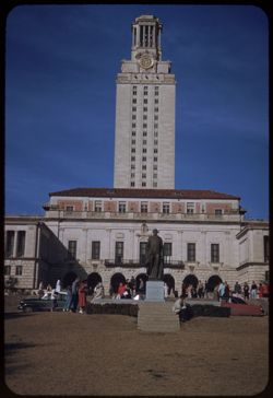
- Description:
- 100 f 8 sl
- Subject:
- Automobiles, Arches, Sculpture, Clock towers, Students, University of Texas at Austin, Columns, Universities & colleges, Lawns, Masonry, and Windows
- Series:
- 4-59
- Creator:
- Cushman, Charles W., 1896-1972
- Date Created:
- 1959-01-16
- Genre:
- Architectural photographs
- Frame Number:
- 10
- County:
- Travis
- Abstract:
- Clock tower Univ of Texas
- Call Number:
- P10474
- City:
- Austin
- Country:
- United States
- State/Province:
- Texas
- Alternate Identifier:
- 459.10
- Persistent URL:
- http://purl.dlib.indiana.edu/iudl/archives/cushman/P10474
- Holding Location:
- Bloomington - University Archives
Wells Library E460
1320 E 10th St.
Bloomington, IN 47405
Contact at archives@indiana.edu, 812-855-1127
-
- Description:
- 25 f 8
- Subject:
- Towers, Mission churches, Missions, Trees, Arches, Religious architectural elements, State parks & reserves, Shrubs, Masonry, Mission Concepción (San Ant...
- Series:
- 3-59
- Creator:
- Cushman, Charles W., 1896-1972
- Date Created:
- 1959-01-15
- Genre:
- Architectural photographs
- Frame Number:
- 32
- County:
- Bexar
- Abstract:
- Concepcion Mission.
- Call Number:
- P10458
- City:
- San Antonio
- Country:
- United States
- State/Province:
- Texas
- Alternate Identifier:
- 359.32
- Persistent URL:
- http://purl.dlib.indiana.edu/iudl/archives/cushman/P10458
- Holding Location:
- Bloomington - University Archives
Wells Library E460
1320 E 10th St.
Bloomington, IN 47405
Contact at archives@indiana.edu, 812-855-1127
-
- Description:
- 25 f 11
- Subject:
- Mission churches, Missions, Mission San José y San Miguel de Aguayo (San Antonio, Tex.), Arches, Shrubs, and Masonry
- Series:
- 3-59
- Creator:
- Cushman, Charles W., 1896-1972
- Date Created:
- 1959-01-15
- Genre:
- Architectural photographs
- Frame Number:
- 38
- County:
- Bexar
- Abstract:
- Arches.
- Call Number:
- P10464
- City:
- San Antonio
- Country:
- United States
- State/Province:
- Texas
- Alternate Identifier:
- 359.38
- Persistent URL:
- http://purl.dlib.indiana.edu/iudl/archives/cushman/P10464
- Holding Location:
- Bloomington - University Archives
Wells Library E460
1320 E 10th St.
Bloomington, IN 47405
Contact at archives@indiana.edu, 812-855-1127
-
- Description:
- 25 f 11
- Subject:
- Mission churches, Missions, Mission San José y San Miguel de Aguayo (San Antonio, Tex.), Trees, Arches, Yard ornaments, Lawns, Shrubs, Masonry, Domes, Religi...
- Series:
- 3-59
- Creator:
- Cushman, Charles W., 1896-1972
- Date Created:
- 1959-01-15
- Genre:
- Architectural photographs
- Frame Number:
- 34
- County:
- Bexar
- Abstract:
- SW corner San Jose Mission.
- Call Number:
- P10460
- City:
- San Antonio
- Country:
- United States
- State/Province:
- Texas
- Alternate Identifier:
- 359.34
- Persistent URL:
- http://purl.dlib.indiana.edu/iudl/archives/cushman/P10460
- Holding Location:
- Bloomington - University Archives
Wells Library E460
1320 E 10th St.
Bloomington, IN 47405
Contact at archives@indiana.edu, 812-855-1127
-
- Description:
- 50 f 8
- Subject:
- Plains, Mountains, Dirt roads, Shrubs, Sierra Blanca Mountains (Tex.), and Grasses
- Series:
- 12-53
- Creator:
- Cushman, Charles W., 1896-1972
- Date Created:
- 1953-11-15
- Genre:
- Landscape photographs
- Frame Number:
- 36
- County:
- Hudspeth
- Abstract:
- Sierra Blanca Mtn. (7000 ft)
- Call Number:
- P06954
- City:
- Sierra Blanca
- Country:
- United States
- State/Province:
- Texas
- Alternate Identifier:
- 1253.36
- Persistent URL:
- http://purl.dlib.indiana.edu/iudl/archives/cushman/P06954
- Holding Location:
- Bloomington - University Archives
Wells Library E460
1320 E 10th St.
Bloomington, IN 47405
Contact at archives@indiana.edu, 812-855-1127
-
- Description:
- 50 f 8
- Subject:
- Sid Richardson Carbon Company, Smoke, Factories, Dirt, Utility poles, Trees, Clouds, and Grasses
- Series:
- 12-53
- Creator:
- Cushman, Charles W., 1896-1972
- Date Created:
- 1953-11-15
- Genre:
- Landscape photographs and Snapshots
- Frame Number:
- 30
- Street Address:
- United States Highway 80
- County:
- Ector
- Abstract:
- View N.E. from west of plant
- Call Number:
- P06948
- City:
- Odessa
- Country:
- United States
- State/Province:
- Texas
- Alternate Identifier:
- 1253.30
- Persistent URL:
- http://purl.dlib.indiana.edu/iudl/archives/cushman/P06948
- Holding Location:
- Bloomington - University Archives
Wells Library E460
1320 E 10th St.
Bloomington, IN 47405
Contact at archives@indiana.edu, 812-855-1127
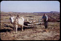
-
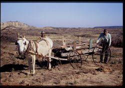
- Description:
- 50 f 8
- Subject:
- Mesquite, Grasses, Ethnic groups, Carts & wagons, Tree limbs, Croplands, Agricultural laborers, Harnesses, Mules, Hills, Wheels, Lumber, and Men
- Series:
- 12-53
- Creator:
- Cushman, Charles W., 1896-1972
- Date Created:
- 1953-11-14
- Genre:
- Snapshots and Portraits
- Frame Number:
- 26
- Street Address:
- United States Highway 80
- County:
- Erath
- Abstract:
- Mule and cart & partly cleared Mesquite acreage near Thurber
- Call Number:
- P06944
- City:
- Thurber
- Country:
- United States
- State/Province:
- Texas
- Physical Description:
- Image was originally mounted in a glass enclosure. Before digitization, the image was removed and placed in a Wess Plastic, Inc. brand, 2" x 2", pl...
- Alternate Identifier:
- 1253.26
- Persistent URL:
- http://purl.dlib.indiana.edu/iudl/archives/cushman/P06944
- Holding Location:
- Bloomington - University Archives
Wells Library E460
1320 E 10th St.
Bloomington, IN 47405
Contact at archives@indiana.edu, 812-855-1127
-
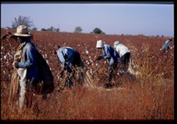
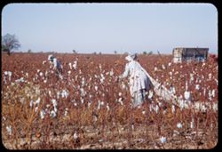
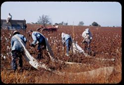
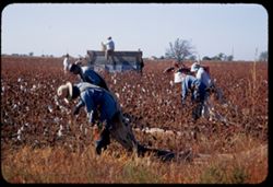
- Description:
- 50 f 8
- Subject:
- Cotton, Grasses, Bags, Trees, Cotton pickers, Harvesting, Croplands, Agricultural laborers, Bonnets, Hats, Tractors, and African Americans
- Series:
- 12-53
- Creator:
- Cushman, Charles W., 1896-1972
- Date Created:
- 1953-11-13
- Genre:
- Snapshots
- Frame Number:
- 18
- Street Address:
- United States Highway 67
- County:
- Hopkins
- Abstract:
- Cotton picking along US 67 near Cumby
- Call Number:
- P06936
- City:
- Cumby
- Country:
- United States
- State/Province:
- Texas
- Physical Description:
- Image was originally mounted in a glass enclosure. Before digitization, the image was removed and placed in a Wess Plastic, Inc. brand, 2" x 2", pl...
- Alternate Identifier:
- 1253.18
- Persistent URL:
- http://purl.dlib.indiana.edu/iudl/archives/cushman/P06936
- Holding Location:
- Bloomington - University Archives
Wells Library E460
1320 E 10th St.
Bloomington, IN 47405
Contact at archives@indiana.edu, 812-855-1127
-
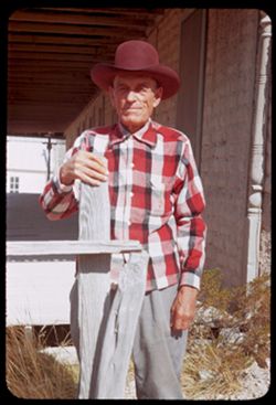
- Description:
- 50 f 6.3
- Subject:
- Men, Grasses, Hands, Cowboy hats, Fences, Porches, Columns, Smiling, and Aged persons
- Series:
- 12-53
- Creator:
- Cushman, Charles W., 1896-1972
- Date Created:
- 1953-11-15
- Genre:
- Portraits
- Frame Number:
- 34
- County:
- Pecos
- Persons Pictured:
- Webber, Gene
- Abstract:
- Gene Webber - Ft Stockton, Tex.
- Call Number:
- P06952
- City:
- Fort Stockton
- Country:
- United States
- State/Province:
- Texas
- Alternate Identifier:
- 1253.34
- Persistent URL:
- http://purl.dlib.indiana.edu/iudl/archives/cushman/P06952
- Holding Location:
- Bloomington - University Archives
Wells Library E460
1320 E 10th St.
Bloomington, IN 47405
Contact at archives@indiana.edu, 812-855-1127
-
- Description:
- 50 f 6.3
- Subject:
- Trailers, Women, Bags, Trees, Cotton pickers, Croplands, Agricultural laborers, Bonnets, Tractors, and Cotton
- Series:
- 12-53
- Creator:
- Cushman, Charles W., 1896-1972
- Date Created:
- 1953-11-13
- Genre:
- Snapshots
- Frame Number:
- 22
- Street Address:
- United States Highway 67
- County:
- Hopkins
- Abstract:
- Cotton picking along US 67 near Cumby
- Call Number:
- P06940
- City:
- Cumby
- Country:
- United States
- State/Province:
- Texas
- Alternate Identifier:
- 1253.22
- Persistent URL:
- http://purl.dlib.indiana.edu/iudl/archives/cushman/P06940
- Holding Location:
- Bloomington - University Archives
Wells Library E460
1320 E 10th St.
Bloomington, IN 47405
Contact at archives@indiana.edu, 812-855-1127
-
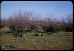
- Description:
- 50 f 8
- Subject:
- Mesquite, Grasses, Cactus, Trees, and Tree limbs
- Series:
- 12-53
- Creator:
- Cushman, Charles W., 1896-1972
- Date Created:
- 1953-11-14
- Genre:
- Landscape photographs and Identification photographs
- Frame Number:
- 28
- Street Address:
- United States Highway 80
- County:
- Erath
- Abstract:
- Mesquite & cactus - west of Thurber
- Call Number:
- P06946
- City:
- Thurber
- Country:
- United States
- State/Province:
- Texas
- Alternate Identifier:
- 1253.28
- Persistent URL:
- http://purl.dlib.indiana.edu/iudl/archives/cushman/P06946
- Holding Location:
- Bloomington - University Archives
Wells Library E460
1320 E 10th St.
Bloomington, IN 47405
Contact at archives@indiana.edu, 812-855-1127
-
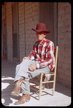
- Description:
- 50 f 5.6
- Subject:
- Men, Hands, Shadows, Bricks, Aged persons, Chairs, Porches, Cowboy boots, Smiling, and Cowboy hats
- Series:
- 12-53
- Creator:
- Cushman, Charles W., 1896-1972
- Date Created:
- 1953-11-15
- Genre:
- Portraits
- Frame Number:
- 33
- County:
- Pecos
- Persons Pictured:
- Webber, Gene
- Abstract:
- Gene Webber - Ft Stockton, Tex.
- Call Number:
- P06951
- City:
- Fort Stockton
- Country:
- United States
- State/Province:
- Texas
- Alternate Identifier:
- 1253.33
- Persistent URL:
- http://purl.dlib.indiana.edu/iudl/archives/cushman/P06951
- Holding Location:
- Bloomington - University Archives
Wells Library E460
1320 E 10th St.
Bloomington, IN 47405
Contact at archives@indiana.edu, 812-855-1127
-
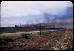
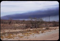
- Description:
- 50 f 8
- Subject:
- Rocks, Electric lines, Roads, Smoke pall, Clouds, Sid Richardson Carbon Company, Utility poles, Water towers, Grasses, Factories, Smoke, and Railroad tracks
- Series:
- 12-53
- Creator:
- Cushman, Charles W., 1896-1972
- Date Created:
- 1953-11-15
- Genre:
- Snapshots
- Frame Number:
- 29
- Street Address:
- United States Highway 80
- County:
- Ector
- Abstract:
- Smoke pall over Sid Richardson Carbon Co. plant from US 80 - 9 mi. west of Odessa
- Call Number:
- P06947
- City:
- Odessa
- Country:
- United States
- State/Province:
- Texas
- Alternate Identifier:
- 1253.29
- Persistent URL:
- http://purl.dlib.indiana.edu/iudl/archives/cushman/P06947
- Holding Location:
- Bloomington - University Archives
Wells Library E460
1320 E 10th St.
Bloomington, IN 47405
Contact at archives@indiana.edu, 812-855-1127
-
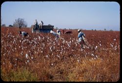
- Description:
- 50 f 8
- Subject:
- Men, Cotton, Grasses, Women, Trees, Cotton pickers, Harvesting, Croplands, Agricultural laborers, Hats, Tractors, and Trailers
- Series:
- 12-53
- Creator:
- Cushman, Charles W., 1896-1972
- Date Created:
- 1953-11-13
- Genre:
- Snapshots
- Frame Number:
- 21
- Street Address:
- United States Highway 67
- County:
- Hopkins
- Abstract:
- Cotton picking along US 67 near Cumby
- Call Number:
- P06939
- City:
- Cumby
- Country:
- United States
- State/Province:
- Texas
- Alternate Identifier:
- 1253.21
- Persistent URL:
- http://purl.dlib.indiana.edu/iudl/archives/cushman/P06939
- Holding Location:
- Bloomington - University Archives
Wells Library E460
1320 E 10th St.
Bloomington, IN 47405
Contact at archives@indiana.edu, 812-855-1127
-
- Description:
- 50 f 6.3
- Subject:
- Lumber, Grasses, Ethnic groups, Carts & wagons, Tree limbs, Croplands, Agricultural laborers, Harnesses, Mules, Hills, Wheels, Mesquite, and Men
- Series:
- 12-53
- Creator:
- Cushman, Charles W., 1896-1972
- Date Created:
- 1953-11-14
- Genre:
- Snapshots and Portraits
- Frame Number:
- 27
- Street Address:
- United States Highway 80
- County:
- Erath
- Abstract:
- Mule and cart & partly cleared Mesquite acreage near Thurber
- Call Number:
- P06945
- City:
- Thurber
- Country:
- United States
- State/Province:
- Texas
- Alternate Identifier:
- 1253.27
- Persistent URL:
- http://purl.dlib.indiana.edu/iudl/archives/cushman/P06945
- Holding Location:
- Bloomington - University Archives
Wells Library E460
1320 E 10th St.
Bloomington, IN 47405
Contact at archives@indiana.edu, 812-855-1127
-
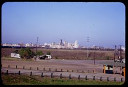
- Description:
- 50 f 8
- Subject:
- Billboards, Electric lines, Roads, Burnett Field (Dallas, Tex.), Stadiums, Business districts, Utility poles, Grasses, Trees, Skyscrapers, Buildings, and Bur...
- Series:
- 12-53
- Creator:
- Cushman, Charles W., 1896-1972
- Date Created:
- 1953-11-13
- Genre:
- Cityscape photographs
- Frame Number:
- 24
- Street Address:
- Jefferson Boulevard
- County:
- Dallas
- Abstract:
- Dallas business center from Jefferson Blvd at Burnett Stadium across the Great Divide SW
- Call Number:
- P06942
- City:
- Dallas
- Country:
- United States
- State/Province:
- Texas
- Alternate Identifier:
- 1253.24
- Persistent URL:
- http://purl.dlib.indiana.edu/iudl/archives/cushman/P06942
- Holding Location:
- Bloomington - University Archives
Wells Library E460
1320 E 10th St.
Bloomington, IN 47405
Contact at archives@indiana.edu, 812-855-1127
-
- Description:
- 50 f 8
- Subject:
- Quitman Mountains (Tex.), Mountains, Shrubs, Rocks, and Grasses
- Series:
- 12-53
- Creator:
- Cushman, Charles W., 1896-1972
- Date Created:
- 1953-11-15
- Genre:
- Landscape photographs
- Frame Number:
- 37
- Street Address:
- United States Highway 80
- County:
- El Paso and Hudspeth
- Abstract:
- Quitman Mtns from loop of US 80 - 75 mi. from El Paso
- Call Number:
- P06955
- City:
- El Paso
- Country:
- United States
- State/Province:
- Texas
- Alternate Identifier:
- 1253.37
- Persistent URL:
- http://purl.dlib.indiana.edu/iudl/archives/cushman/P06955
- Holding Location:
- Bloomington - University Archives
Wells Library E460
1320 E 10th St.
Bloomington, IN 47405
Contact at archives@indiana.edu, 812-855-1127
-
- Description:
- 50 f 6.3
- Subject:
- Cotton, Harvesting, Croplands, Bags, African Americans, Bonnets, Hats, Trees, Trailers, Cotton pickers, Agricultural laborers, and Tractors
- Series:
- 12-53
- Creator:
- Cushman, Charles W., 1896-1972
- Date Created:
- 1953-11-13
- Genre:
- Snapshots
- Frame Number:
- 19
- Street Address:
- United States Highway 67
- County:
- Hopkins
- Abstract:
- Cotton picking along US 67 near Cumby
- Call Number:
- P06937
- City:
- Cumby
- Country:
- United States
- State/Province:
- Texas
- Alternate Identifier:
- 1253.19
- Persistent URL:
- http://purl.dlib.indiana.edu/iudl/archives/cushman/P06937
- Holding Location:
- Bloomington - University Archives
Wells Library E460
1320 E 10th St.
Bloomington, IN 47405
Contact at archives@indiana.edu, 812-855-1127
-
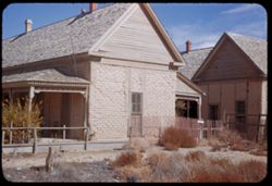
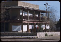
- Description:
- 50 f 8
- Subject:
- Hotels, Chimneys, Railings, Grasses, Porches, Fences, Roofs, Adobe buildings, and Doors & doorways
- Series:
- 12-53
- Creator:
- Cushman, Charles W., 1896-1972
- Date Created:
- 1953-11-15
- Genre:
- Architectural photographs
- Frame Number:
- 32
- County:
- Pecos
- Abstract:
- Fort Stockton - back of old adobe hotel from another angle
- Call Number:
- P06950
- City:
- Fort Stockton
- Country:
- United States
- State/Province:
- Texas
- Alternate Identifier:
- 1253.32
- Persistent URL:
- http://purl.dlib.indiana.edu/iudl/archives/cushman/P06950
- Holding Location:
- Bloomington - University Archives
Wells Library E460
1320 E 10th St.
Bloomington, IN 47405
Contact at archives@indiana.edu, 812-855-1127
-

- Description:
- 50 f 8
- Subject:
- Tree limbs, Chimneys, Houses, Windows, Gables, Shrubs, Railings, Porches, and Roofs
- Series:
- 12-53
- Creator:
- Cushman, Charles W., 1896-1972
- Date Created:
- 1953-11-13
- Genre:
- Architectural photographs
- Frame Number:
- 17
- County:
- Franklin
- Abstract:
- Pink house: Mount Vernon, Texas
- Call Number:
- P06935
- City:
- Mount Vernon
- Country:
- United States
- State/Province:
- Texas
- Physical Description:
- masked.
- Alternate Identifier:
- 1253.17
- Persistent URL:
- http://purl.dlib.indiana.edu/iudl/archives/cushman/P06935
- Holding Location:
- Bloomington - University Archives
Wells Library E460
1320 E 10th St.
Bloomington, IN 47405
Contact at archives@indiana.edu, 812-855-1127
-
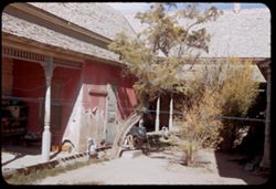
- Description:
- 50 F 6.3
- Subject:
- Grasses, Adobe buildings, Trees, Roofs, Hotels, Porches, Columns, and Building deterioration
- Series:
- 12-53
- Creator:
- Cushman, Charles W., 1896-1972
- Date Created:
- 1953-11-15
- Genre:
- Architectural photographs
- Frame Number:
- 31
- County:
- Pecos
- Abstract:
- Fort Stockton - back of old adobe hotel
- Call Number:
- P06949
- City:
- Fort Stockton
- Country:
- United States
- State/Province:
- Texas
- Alternate Identifier:
- 1253.31
- Persistent URL:
- http://purl.dlib.indiana.edu/iudl/archives/cushman/P06949
- Holding Location:
- Bloomington - University Archives
Wells Library E460
1320 E 10th St.
Bloomington, IN 47405
Contact at archives@indiana.edu, 812-855-1127
-
- Description:
- 50 f 4.5 POLA
- Subject:
- Grasses, Gomez Peak (Tex.), Shrubs, Hills, and Mountains
- Series:
- 12-53
- Creator:
- Cushman, Charles W., 1896-1972
- Date Created:
- 1953-11-15
- Genre:
- Landscape photographs
- Frame Number:
- 35
- Street Address:
- United States Highway 80 and United States Highway 290
- County:
- Jeff Davis
- Abstract:
- Gomez Pk (6323) from US 80 west of intersection US 80-290
- Call Number:
- P06953
- Country:
- United States
- State/Province:
- Texas
- Alternate Identifier:
- 1253.35
- Persistent URL:
- http://purl.dlib.indiana.edu/iudl/archives/cushman/P06953
- Holding Location:
- Bloomington - University Archives
Wells Library E460
1320 E 10th St.
Bloomington, IN 47405
Contact at archives@indiana.edu, 812-855-1127
-
- Description:
- 50 f 8
- Subject:
- Grasses, Trees, Dirt, Tree limbs, Shrubs, and Hills
- Series:
- 12-53
- Creator:
- Cushman, Charles W., 1896-1972
- Date Created:
- 1953-11-14
- Genre:
- Landscape photographs
- Frame Number:
- 25
- County:
- Eastland
- Abstract:
- Texas landscape 25 mi. east of Ranger
- Call Number:
- P06943
- City:
- Ranger
- Country:
- United States
- State/Province:
- Texas
- Alternate Identifier:
- 1253.25
- Persistent URL:
- http://purl.dlib.indiana.edu/iudl/archives/cushman/P06943
- Holding Location:
- Bloomington - University Archives
Wells Library E460
1320 E 10th St.
Bloomington, IN 47405
Contact at archives@indiana.edu, 812-855-1127
-
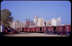
- Description:
- 50 f 8
- Subject:
- Skyscrapers, Buildings, Railroad shops & yards, Trucks, Business districts, Railroad cars, Railroads, and Trees
- Series:
- 12-53
- Creator:
- Cushman, Charles W., 1896-1972
- Date Created:
- 1953-11-13
- Genre:
- Cityscape photographs
- Frame Number:
- 23
- County:
- Dallas
- Abstract:
- Dallas business center seen from RR yards SW
- Call Number:
- P06941
- City:
- Dallas
- Country:
- United States
- State/Province:
- Texas
- Physical Description:
- masked.
- Alternate Identifier:
- 1253.23
- Persistent URL:
- http://purl.dlib.indiana.edu/iudl/archives/cushman/P06941
- Holding Location:
- Bloomington - University Archives
Wells Library E460
1320 E 10th St.
Bloomington, IN 47405
Contact at archives@indiana.edu, 812-855-1127
-
- Description:
- 50 f 6.3
- Subject:
- Trailers, Grasses, Bags, Trees, Cotton pickers, Harvesting, Croplands, Agricultural laborers, Hats, Tractors, African Americans, and Cotton
- Series:
- 12-53
- Creator:
- Cushman, Charles W., 1896-1972
- Date Created:
- 1953-11-13
- Genre:
- Snapshots
- Frame Number:
- 20
- Street Address:
- United States Highway 67
- County:
- Hopkins
- Abstract:
- Cotton picking along US 67 near Cumby
- Call Number:
- P06938
- City:
- Cumby
- Country:
- United States
- State/Province:
- Texas
- Alternate Identifier:
- 1253.20
- Persistent URL:
- http://purl.dlib.indiana.edu/iudl/archives/cushman/P06938
- Holding Location:
- Bloomington - University Archives
Wells Library E460
1320 E 10th St.
Bloomington, IN 47405
Contact at archives@indiana.edu, 812-855-1127
-
- Description:
- 50 f 8
- Subject:
- Hills, Roads, Franklin Mountains (Tex. and N.M.), Mountains, Shrubs, Shadows, and Clouds
- Series:
- 17-51
- Creator:
- Cushman, Charles W., 1896-1972
- Date Created:
- 1952-01-01
- Genre:
- Landscape photographs
- Frame Number:
- 30
- County:
- El Paso
- Abstract:
- Whorls on a Mtn. side = Franklin Mtns.
- Call Number:
- P05481
- City:
- El Paso
- Country:
- United States
- State/Province:
- Texas
- Alternate Identifier:
- 1751.30
- Persistent URL:
- http://purl.dlib.indiana.edu/iudl/archives/cushman/P05481
- Holding Location:
- Bloomington - University Archives
Wells Library E460
1320 E 10th St.
Bloomington, IN 47405
Contact at archives@indiana.edu, 812-855-1127
-

- Description:
- 50 f 8
- Subject:
- Sleeping, Rocks, Ethnic groups, Men, Mexicans, Shadows, Streets, Mexican Americans, and City & town life
- Series:
- 17-51
- Creator:
- Cushman, Charles W., 1896-1972
- Date Created:
- 1952-01-01
- Genre:
- Portraits
- Frame Number:
- 33
- County:
- El Paso
- Abstract:
- Dead Mex.
- Call Number:
- P05484
- City:
- El Paso
- Country:
- United States
- State/Province:
- Texas
- Alternate Identifier:
- 1751.33
- Persistent URL:
- http://purl.dlib.indiana.edu/iudl/archives/cushman/P05484
- Holding Location:
- Bloomington - University Archives
Wells Library E460
1320 E 10th St.
Bloomington, IN 47405
Contact at archives@indiana.edu, 812-855-1127
-
- Description:
- 25 f 11
- Subject:
- Noon, Hills, Cliffs, Franklin Mountains (Tex. and N.M.), Mountains, and Shrubs
- Series:
- 17-51
- Creator:
- Cushman, Charles W., 1896-1972
- Date Created:
- 1952-01-01
- Genre:
- Landscape photographs
- Frame Number:
- 28
- County:
- El Paso
- Abstract:
- Mtns. at noon.
- Call Number:
- P05479
- City:
- El Paso
- Country:
- United States
- State/Province:
- Texas
- Alternate Identifier:
- 1751.28
- Persistent URL:
- http://purl.dlib.indiana.edu/iudl/archives/cushman/P05479
- Holding Location:
- Bloomington - University Archives
Wells Library E460
1320 E 10th St.
Bloomington, IN 47405
Contact at archives@indiana.edu, 812-855-1127
-
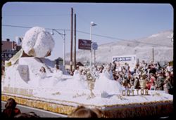
- Subject:
- Cotton queen, Spectators, Chevron Oil Company, Parades & processions, Signs (Notices), Streets, Automobile service stations, Mountains, Street lights, El...
- Series:
- 17-51
- Creator:
- Cushman, Charles W., 1896-1972
- Date Created:
- 1952-01-01
- Genre:
- Snapshots and Portraits
- Frame Number:
- 20
- County:
- El Paso
- Abstract:
- a few at f 5.6, 15 to 26 = Paraders, floats, onlookers. 125 f 4.5, and some at f 4
- Call Number:
- P05472
- City:
- El Paso
- Country:
- United States
- State/Province:
- Texas
- Alternate Identifier:
- 1751.20
- Persistent URL:
- http://purl.dlib.indiana.edu/iudl/archives/cushman/P05472
- Holding Location:
- Bloomington - University Archives
Wells Library E460
1320 E 10th St.
Bloomington, IN 47405
Contact at archives@indiana.edu, 812-855-1127
-
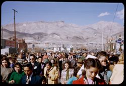
- Subject:
- Crowds, Electric lines, Floats (Parades), Signs (Notices), Sun Bowl Parade (El Paso, Tex.), Onlookers, Mountains, Buildings, Electric signs, Parades & pr...
- Series:
- 17-51
- Creator:
- Cushman, Charles W., 1896-1972
- Date Created:
- 1952-01-01
- Genre:
- Snapshots
- Frame Number:
- 25
- County:
- El Paso
- Abstract:
- a few at f 5.6, 15 to 26 = Paraders, floats, onlookers. 125 f 4.5, and some at f 4
- Call Number:
- P05476
- City:
- El Paso
- Country:
- United States
- State/Province:
- Texas
- Alternate Identifier:
- 1751.25
- Persistent URL:
- http://purl.dlib.indiana.edu/iudl/archives/cushman/P05476
- Holding Location:
- Bloomington - University Archives
Wells Library E460
1320 E 10th St.
Bloomington, IN 47405
Contact at archives@indiana.edu, 812-855-1127
-
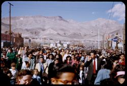
- Subject:
- Crowds, Parades & processions, Signs (Notices), Sun Bowl Parade (El Paso, Tex.), Onlookers, Mountains, Buildings, Festivals, People, Floats (Parades), St...
- Series:
- 17-51
- Creator:
- Cushman, Charles W., 1896-1972
- Date Created:
- 1952-01-01
- Genre:
- Snapshots
- Frame Number:
- 24
- County:
- El Paso
- Abstract:
- a few at f 5.6, 15 to 26 = Paraders, floats, onlookers. 125 f 4.5, and some at f 4
- Call Number:
- P05475
- City:
- El Paso
- Country:
- United States
- State/Province:
- Texas
- Alternate Identifier:
- 1751.24
- Persistent URL:
- http://purl.dlib.indiana.edu/iudl/archives/cushman/P05475
- Holding Location:
- Bloomington - University Archives
Wells Library E460
1320 E 10th St.
Bloomington, IN 47405
Contact at archives@indiana.edu, 812-855-1127
-
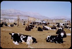
- Description:
- 25 f 11
- Subject:
- Feed lot, Cattle, Animal feeding, Mountains, Fences, and Trucks
- Series:
- 17-51
- Creator:
- Cushman, Charles W., 1896-1972
- Date Created:
- 1952-01-02
- Genre:
- Snapshots
- Frame Number:
- 35
- Street Address:
- Reynolds Street and Montana Street
- County:
- El Paso
- Abstract:
- Feed lot - El Paso - Reynolds St. south of Montana.
- Call Number:
- P05486
- City:
- El Paso
- Country:
- United States
- State/Province:
- Texas
- Alternate Identifier:
- 1751.35
- Persistent URL:
- http://purl.dlib.indiana.edu/iudl/archives/cushman/P05486
- Holding Location:
- Bloomington - University Archives
Wells Library E460
1320 E 10th St.
Bloomington, IN 47405
Contact at archives@indiana.edu, 812-855-1127
-
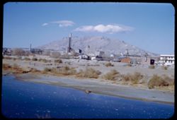
- Description:
- 50 f 8
- Subject:
- Franklin Mountains (Tex. and N.M.), Industrial facilities, Rio Grande, Mountains, Buildings, Shrubs, People, Smokestacks, and Rivers
- Series:
- 1-52
- Creator:
- Cushman, Charles W., 1896-1972
- Date Created:
- 1952-01-02
- Genre:
- Cityscape photographs
- Frame Number:
- 9
- County:
- El Paso
- Abstract:
- El Paso from Juarez.
- Call Number:
- P05499
- City:
- El Paso
- Country:
- United States
- State/Province:
- Texas
- Alternate Identifier:
- 152.9
- Persistent URL:
- http://purl.dlib.indiana.edu/iudl/archives/cushman/P05499
- Holding Location:
- Bloomington - University Archives
Wells Library E460
1320 E 10th St.
Bloomington, IN 47405
Contact at archives@indiana.edu, 812-855-1127
-
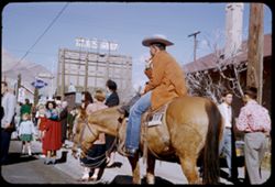
- Subject:
- Horseback riding, Tree limbs, Billboards, Horses, Streets, Sun Bowl Parade (El Paso, Tex.), Spectators, Mountains, People, Onlookers, Floats (Parades), Build...
- Series:
- 17-51
- Creator:
- Cushman, Charles W., 1896-1972
- Date Created:
- 1952-01-01
- Genre:
- Portraits and Snapshots
- Frame Number:
- 22
- County:
- El Paso
- Abstract:
- some at f 4, a few at f 5.6, and 15 to 26 = Paraders, floats, onlookers. 125 f 4.5
- Call Number:
- P05474
- City:
- El Paso
- Country:
- United States
- State/Province:
- Texas
- Alternate Identifier:
- 1751.22
- Persistent URL:
- http://purl.dlib.indiana.edu/iudl/archives/cushman/P05474
- Holding Location:
- Bloomington - University Archives
Wells Library E460
1320 E 10th St.
Bloomington, IN 47405
Contact at archives@indiana.edu, 812-855-1127
-
- Description:
- 50 f 8
- Subject:
- Stone buildings, Houses, Facades, Windows, Franklin Mountains (Tex. and N.M.), Mountains, Stone houses, Utility poles, Cactus, Trees, Doors & doorways, a...
- Series:
- 17-51
- Creator:
- Cushman, Charles W., 1896-1972
- Date Created:
- 1952-01-01
- Genre:
- Landscape photographs and Architectural photographs
- Frame Number:
- 31
- County:
- El Paso
- Abstract:
- Stone house + mtn. backdrop - Franklin Mtns.
- Call Number:
- P05482
- City:
- El Paso
- Country:
- United States
- State/Province:
- Texas
- Alternate Identifier:
- 1751.31
- Persistent URL:
- http://purl.dlib.indiana.edu/iudl/archives/cushman/P05482
- Holding Location:
- Bloomington - University Archives
Wells Library E460
1320 E 10th St.
Bloomington, IN 47405
Contact at archives@indiana.edu, 812-855-1127
-
- Description:
- 50 f 9
- Subject:
- Water towers, Plains, Hills, Roads, Franklin Mountains (Tex. and N.M.), Mountains, Shrubs, Shadows, Clouds, Buildings, and Rocks
- Series:
- 17-51
- Creator:
- Cushman, Charles W., 1896-1972
- Date Created:
- 1952-01-01
- Genre:
- Landscape photographs and Cityscape photographs
- Frame Number:
- 32
- County:
- El Paso
- Abstract:
- Strange long cloud over Fort Bliss from Franklin Mtns.
- Call Number:
- P05483
- City:
- Fort Bliss
- Country:
- United States
- State/Province:
- Texas
- Alternate Identifier:
- 1751.32
- Persistent URL:
- http://purl.dlib.indiana.edu/iudl/archives/cushman/P05483
- Holding Location:
- Bloomington - University Archives
Wells Library E460
1320 E 10th St.
Bloomington, IN 47405
Contact at archives@indiana.edu, 812-855-1127
-
- Subject:
- Domes, Gazebos, Churches, Streets, Automobiles, Windows, Mexican church, Rose windows, Mountains, Towers, Doors & doorways, Stone walls, Crosses, Frankli...
- Series:
- 17-51
- Creator:
- Cushman, Charles W., 1896-1972
- Date Created:
- 1952-01-01
- Genre:
- Architectural photographs
- Frame Number:
- 26
- County:
- El Paso
- Abstract:
- some at f 4, a few at f 5.6 Franklin Mtns. behind little Mex. church., and 15 to 26 = Paraders, floats, onlookers. 125 f 4.5
- Call Number:
- P05477
- City:
- El Paso
- Country:
- United States
- State/Province:
- Texas
- Alternate Identifier:
- 1751.26
- Persistent URL:
- http://purl.dlib.indiana.edu/iudl/archives/cushman/P05477
- Holding Location:
- Bloomington - University Archives
Wells Library E460
1320 E 10th St.
Bloomington, IN 47405
Contact at archives@indiana.edu, 812-855-1127
-
- Description:
- 50 f 8
- Subject:
- Hills, Roads, Franklin Mountains (Tex. and N.M.), Mountains, Shrubs, Shadows, and Clouds
- Series:
- 17-51
- Creator:
- Cushman, Charles W., 1896-1972
- Date Created:
- 1952-01-01
- Genre:
- Landscape photographs
- Frame Number:
- 29
- County:
- El Paso
- Abstract:
- High peak of Franklin Mtns.
- Call Number:
- P05480
- City:
- El Paso
- Country:
- United States
- State/Province:
- Texas
- Alternate Identifier:
- 1751.29
- Persistent URL:
- http://purl.dlib.indiana.edu/iudl/archives/cushman/P05480
- Holding Location:
- Bloomington - University Archives
Wells Library E460
1320 E 10th St.
Bloomington, IN 47405
Contact at archives@indiana.edu, 812-855-1127
-
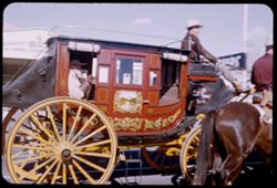
- Subject:
- Men, Parades & processions, Carriages & coaches, Sun Bowl Parade (El Paso, Tex.), Onlookers, Buildings, Horseback riding, Floats (Parades), Horses, S...
- Series:
- 17-51
- Creator:
- Cushman, Charles W., 1896-1972
- Date Created:
- 1952-01-01
- Genre:
- Snapshots and Portraits
- Frame Number:
- 17
- County:
- El Paso
- Abstract:
- a few at f 5.6, 15 to 26 = Paraders, floats, onlookers. 125 f 4.5, and some at f 4
- Call Number:
- P05471
- City:
- El Paso
- Country:
- United States
- State/Province:
- Texas
- Alternate Identifier:
- 1751.17
- Persistent URL:
- http://purl.dlib.indiana.edu/iudl/archives/cushman/P05471
- Holding Location:
- Bloomington - University Archives
Wells Library E460
1320 E 10th St.
Bloomington, IN 47405
Contact at archives@indiana.edu, 812-855-1127
-
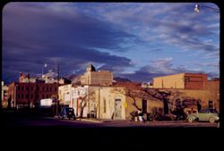
- Description:
- 25 f 11
- Subject:
- Franklin Mountains (Tex. and N.M.), Electric lines, Automobiles, Shadows, Signs (Notices), Streets, Mountains, Buildings, Clouds, Sky, Business districts, Pe...
- Series:
- 17-51
- Creator:
- Cushman, Charles W., 1896-1972
- Date Created:
- 1952-01-01
- Genre:
- Views and Cityscape photographs
- Frame Number:
- 34
- Street Address:
- South Santa Fe Street
- County:
- El Paso
- Abstract:
- El Paso's central district + Franklin Mtns. from So. Santa Fe St.
- Call Number:
- P05485
- City:
- El Paso
- Country:
- United States
- State/Province:
- Texas
- Alternate Identifier:
- 1751.34
- Persistent URL:
- http://purl.dlib.indiana.edu/iudl/archives/cushman/P05485
- Holding Location:
- Bloomington - University Archives
Wells Library E460
1320 E 10th St.
Bloomington, IN 47405
Contact at archives@indiana.edu, 812-855-1127
-
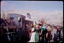
- Subject:
- Spectators, Electric lines, Floats (Parades), Flags, Sun Bowl Carnival, Signs (Notices), Sun Bowl Parade (El Paso, Tex.), Umbrellas, Mountains, Street lights...
- Series:
- 17-51
- Creator:
- Cushman, Charles W., 1896-1972
- Date Created:
- 1952-01-01
- Genre:
- Snapshots
- Frame Number:
- 21
- County:
- El Paso
- Abstract:
- a few at f 5.6, 15 to 26 = Paraders, floats, onlookers. 125 f 4.5, and some at f 4
- Call Number:
- P05473
- City:
- El Paso
- Country:
- United States
- State/Province:
- Texas
- Alternate Identifier:
- 1751.21
- Persistent URL:
- http://purl.dlib.indiana.edu/iudl/archives/cushman/P05473
- Holding Location:
- Bloomington - University Archives
Wells Library E460
1320 E 10th St.
Bloomington, IN 47405
Contact at archives@indiana.edu, 812-855-1127
-
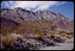
- Description:
- 50 f 8
- Subject:
- Rocks, Cliffs, Noon, Mountains, Shrubs, Hills, and Franklin Mountains (Tex. and N.M.)
- Series:
- 17-51
- Creator:
- Cushman, Charles W., 1896-1972
- Date Created:
- 1952-01-01
- Genre:
- Landscape photographs
- Frame Number:
- 27
- County:
- El Paso
- Abstract:
- High ridge of Franklin.
- Call Number:
- P05478
- City:
- El Paso
- Country:
- United States
- State/Province:
- Texas
- Alternate Identifier:
- 1751.27
- Persistent URL:
- http://purl.dlib.indiana.edu/iudl/archives/cushman/P05478
- Holding Location:
- Bloomington - University Archives
Wells Library E460
1320 E 10th St.
Bloomington, IN 47405
Contact at archives@indiana.edu, 812-855-1127
-
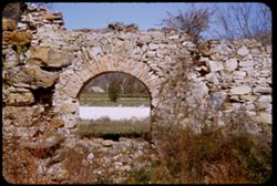
- Description:
- 25 f 9
- Subject:
- National parks & reserves, Stone walls, Ruins, Arches, Mission San Francisco de la Espada (San Antonio, Tex.), Shrubs, San Antonio Missions National Hist...
- Series:
- 15-51
- Creator:
- Cushman, Charles W., 1896-1972
- Date Created:
- 1951-12-23
- Genre:
- Architectural photographs
- Frame Number:
- 8
- County:
- Bexar
- Abstract:
- Another archway-Espada ruins
- Call Number:
- P05390
- City:
- San Antonio
- Country:
- United States
- State/Province:
- Texas
- Alternate Identifier:
- 1551.8
- Persistent URL:
- http://purl.dlib.indiana.edu/iudl/archives/cushman/P05390
- Holding Location:
- Bloomington - University Archives
Wells Library E460
1320 E 10th St.
Bloomington, IN 47405
Contact at archives@indiana.edu, 812-855-1127
-
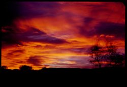
- Description:
- 25 f 2.8
- Subject:
- Sky, Trees, Davis Mountains (Tex.), Clouds, and Sunrises & sunsets
- Series:
- 17-51
- Creator:
- Cushman, Charles W., 1896-1972
- Date Created:
- 1951-12-29
- Genre:
- Landscape photographs
- Frame Number:
- 8
- Street Address:
- Highway 10
- County:
- Jeff Davis
- Abstract:
- Sky from Hwy 10 mi. north of Ft. Davis.
- Call Number:
- P05465
- City:
- Fort Davis
- Country:
- United States
- State/Province:
- Texas
- Alternate Identifier:
- 1751.8
- Persistent URL:
- http://purl.dlib.indiana.edu/iudl/archives/cushman/P05465
- Holding Location:
- Bloomington - University Archives
Wells Library E460
1320 E 10th St.
Bloomington, IN 47405
Contact at archives@indiana.edu, 812-855-1127
-
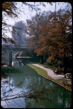
- Description:
- 25 f 8
- Subject:
- San Antonio River (Tex.), Tree limbs, Reflections, Commerce Street Bridge (San Antonio, Tex.), Stairways, Bridges, Lawns, Benches, Trees, Railings, Rivers, a...
- Series:
- 13-51
- Creator:
- Cushman, Charles W., 1896-1972
- Date Created:
- 1951-12-20
- Genre:
- Snapshots
- Frame Number:
- 31
- Street Address:
- Commerce Street
- County:
- Bexar
- Abstract:
- SA river from Commerce St. bridge
- Call Number:
- P05337
- City:
- San Antonio
- Country:
- United States
- State/Province:
- Texas
- Alternate Identifier:
- 1351.31
- Persistent URL:
- http://purl.dlib.indiana.edu/iudl/archives/cushman/P05337
- Holding Location:
- Bloomington - University Archives
Wells Library E460
1320 E 10th St.
Bloomington, IN 47405
Contact at archives@indiana.edu, 812-855-1127
-
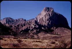
- Description:
- 25 f 11
- Subject:
- National parks & reserves, Pulliam Peak (Tex.), Green Gulch (Tex.), Valleys, Cliffs, Big Bend National Park (Tex.), Mountains, Shrubs, Basin (Big Bend Na...
- Series:
- 16-51
- Creator:
- Cushman, Charles W., 1896-1972
- Date Created:
- 1951-12-27
- Genre:
- Landscape photographs
- Frame Number:
- 4
- County:
- Brewster
- Abstract:
- Great bold front of Pulliam Pk. from Green gulch
- Call Number:
- P05423
- Country:
- United States
- State/Province:
- Texas
- Alternate Identifier:
- 1651.4
- Persistent URL:
- http://purl.dlib.indiana.edu/iudl/archives/cushman/P05423
- Holding Location:
- Bloomington - University Archives
Wells Library E460
1320 E 10th St.
Bloomington, IN 47405
Contact at archives@indiana.edu, 812-855-1127
-
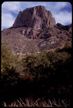
- Description:
- 25 f 9
- Subject:
- National parks & reserves, Casa Grande Peak (Tex.), Cliffs, Big Bend National Park (Tex.), Mountains, Trees, Buttes, and Rock formations
- Series:
- 16-51
- Creator:
- Cushman, Charles W., 1896-1972
- Date Created:
- 1951-12-28
- Genre:
- Landscape photographs
- Frame Number:
- 35
- County:
- Brewster
- Abstract:
- The squarish hump of Casa Grande at 2:30.
- Call Number:
- P05453
- Country:
- United States
- State/Province:
- Texas
- Alternate Identifier:
- 1651.35
- Persistent URL:
- http://purl.dlib.indiana.edu/iudl/archives/cushman/P05453
- Holding Location:
- Bloomington - University Archives
Wells Library E460
1320 E 10th St.
Bloomington, IN 47405
Contact at archives@indiana.edu, 812-855-1127
-
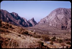
- Description:
- 50 f 8
- Subject:
- Valleys, Hills, Mountains, Lost Mine Trail (Big Bend National Park (Tex.)), Trees, Canyons, National parks & reserves, Big Bend National Park (Tex.), Cli...
- Series:
- 16-51
- Creator:
- Cushman, Charles W., 1896-1972
- Date Created:
- 1951-12-27
- Genre:
- Landscape photographs
- Frame Number:
- 11
- County:
- Brewster
- Abstract:
- Road winds down to The Basin
- Call Number:
- P05430
- Country:
- United States
- State/Province:
- Texas
- Alternate Identifier:
- 1651.11
- Persistent URL:
- http://purl.dlib.indiana.edu/iudl/archives/cushman/P05430
- Holding Location:
- Bloomington - University Archives
Wells Library E460
1320 E 10th St.
Bloomington, IN 47405
Contact at archives@indiana.edu, 812-855-1127
-
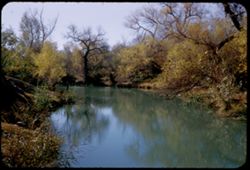
- Description:
- 25 f 9
- Subject:
- San Felipe Creek (Val Verde County, Tex.), Ethnic neighborhoods, Reeds (Plants), Tree limbs, Trees, Streams, Shrubs, and Reflections
- Series:
- 15-51
- Creator:
- Cushman, Charles W., 1896-1972
- Date Created:
- 1951-12-25
- Genre:
- Landscape photographs
- Frame Number:
- 16
- Street Address:
- Mexican section
- County:
- Val Verde
- Abstract:
- San Felipe creek Mex section Del Rio
- Call Number:
- P05398
- City:
- Del Rio
- Country:
- United States
- State/Province:
- Texas
- Alternate Identifier:
- 1551.16
- Persistent URL:
- http://purl.dlib.indiana.edu/iudl/archives/cushman/P05398
- Holding Location:
- Bloomington - University Archives
Wells Library E460
1320 E 10th St.
Bloomington, IN 47405
Contact at archives@indiana.edu, 812-855-1127
-
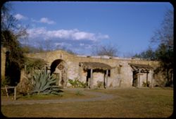
- Description:
- 25 f 11
- Subject:
- Awnings, Missions, Gates, Tree limbs, San Antonio Missions National Historical Park (San Antonio, Tex.), Mission San José y San Miguel de Aguayo (San Antonio...
- Series:
- 14-51
- Creator:
- Cushman, Charles W., 1896-1972
- Date Created:
- 1951-12-20
- Genre:
- Architectural photographs
- Frame Number:
- 12
- County:
- Bexar
- Abstract:
- San Jose Mission
- Call Number:
- P05357
- City:
- San Antonio
- Country:
- United States
- State/Province:
- Texas
- Alternate Identifier:
- 1451.12
- Persistent URL:
- http://purl.dlib.indiana.edu/iudl/archives/cushman/P05357
- Holding Location:
- Bloomington - University Archives
Wells Library E460
1320 E 10th St.
Bloomington, IN 47405
Contact at archives@indiana.edu, 812-855-1127
-
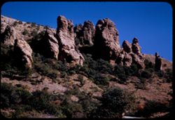
- Description:
- 50 f 8
- Subject:
- National parks & reserves, Thumbs and fingers, Hills, Roads, Cliffs, Big Bend National Park (Tex.), Shrubs, Trees, Buttes, Southwest Texas, and Rock form...
- Series:
- 16-51
- Creator:
- Cushman, Charles W., 1896-1972
- Date Created:
- 1951-12-27
- Genre:
- Landscape photographs
- Frame Number:
- 10
- County:
- Brewster
- Abstract:
- Up at Thumbs & fingers
- Call Number:
- P05429
- Country:
- United States
- State/Province:
- Texas
- Alternate Identifier:
- 1651.10
- Persistent URL:
- http://purl.dlib.indiana.edu/iudl/archives/cushman/P05429
- Holding Location:
- Bloomington - University Archives
Wells Library E460
1320 E 10th St.
Bloomington, IN 47405
Contact at archives@indiana.edu, 812-855-1127
-
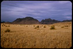
- Description:
- 25 f 9
- Subject:
- Plains, Hills, Mountains, Shrubs, Sawtooth Mountain (Tex.), and Davis Mountains State Park (Tex.)
- Series:
- 17-51
- Creator:
- Cushman, Charles W., 1896-1972
- Date Created:
- 1951-12-29
- Genre:
- Landscape photographs
- Frame Number:
- 5
- Street Address:
- Texas State Highway 166 and Loop Texas State Highway 166
- County:
- Jeff Davis
- Abstract:
- Sawtooth Mtn. from SW.
- Call Number:
- P05462
- Country:
- United States
- State/Province:
- Texas
- Alternate Identifier:
- 1751.5
- Persistent URL:
- http://purl.dlib.indiana.edu/iudl/archives/cushman/P05462
- Holding Location:
- Bloomington - University Archives
Wells Library E460
1320 E 10th St.
Bloomington, IN 47405
Contact at archives@indiana.edu, 812-855-1127
-
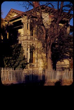
- Description:
- 25 f 9
- Subject:
- Balusters, Tree limbs, Balconies, Houses, Columns, Shrubs, Balustrades, Cornices, Historic buildings, Porches, Fences, and Shadows
- Series:
- 14-51
- Creator:
- Cushman, Charles W., 1896-1972
- Date Created:
- 1951-12-21
- Genre:
- Architectural photographs
- Frame Number:
- 23
- Street Address:
- Dwyer Avenue and Guibeau Street
- County:
- Bexar
- Abstract:
- House of a past era at Guilbeau St. on Dwyer Av.
- Call Number:
- P05368
- City:
- San Antonio
- Country:
- United States
- State/Province:
- Texas
- Physical Description:
- masked.
- Alternate Identifier:
- 1451.23
- Persistent URL:
- http://purl.dlib.indiana.edu/iudl/archives/cushman/P05368
- Holding Location:
- Bloomington - University Archives
Wells Library E460
1320 E 10th St.
Bloomington, IN 47405
Contact at archives@indiana.edu, 812-855-1127
-
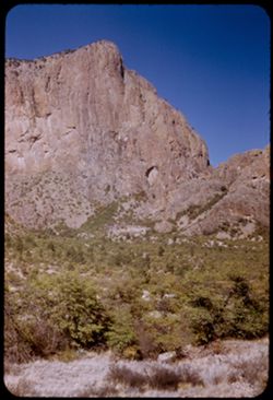
- Description:
- 25 f 11
- Subject:
- Noon, National parks & reserves, Pulliam Peak (Tex.), Canyons, Valleys, Hills, Cliffs, Big Bend National Park (Tex.), Mountains, Shrubs, Trees, Basin (Bi...
- Series:
- 16-51
- Creator:
- Cushman, Charles W., 1896-1972
- Date Created:
- 1951-12-27
- Genre:
- Landscape photographs
- Frame Number:
- 5
- County:
- Brewster
- Abstract:
- Great bold front of Pulliam Pk. From Green gulch from south
- Call Number:
- P05424
- Country:
- United States
- State/Province:
- Texas
- Alternate Identifier:
- 1651.5
- Persistent URL:
- http://purl.dlib.indiana.edu/iudl/archives/cushman/P05424
- Holding Location:
- Bloomington - University Archives
Wells Library E460
1320 E 10th St.
Bloomington, IN 47405
Contact at archives@indiana.edu, 812-855-1127
-
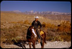
- Description:
- 125 f 4.5
- Subject:
- Horseback riding, Guards, Horses, Men, Hills, Border patrols, Boquillas Canyon (Big Bend National Park (Tex.)), Cliffs, Mountains, Shrubs, Cactus, Mounted po...
- Series:
- 16-51
- Creator:
- Cushman, Charles W., 1896-1972
- Date Created:
- 1951-12-27
- Genre:
- Portraits
- Frame Number:
- 17
- County:
- Brewster
- Abstract:
- Border patrol near Boquillas.
- Call Number:
- P05436
- Country:
- United States
- State/Province:
- Texas
- Alternate Identifier:
- 1651.17
- Persistent URL:
- http://purl.dlib.indiana.edu/iudl/archives/cushman/P05436
- Holding Location:
- Bloomington - University Archives
Wells Library E460
1320 E 10th St.
Bloomington, IN 47405
Contact at archives@indiana.edu, 812-855-1127
-
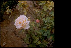
- Description:
- 25 f 6.3
- Subject:
- Leaves, Flowers, Christmas, Shrubs, Christmas rose, Buds, and Roses
- Series:
- 15-51
- Creator:
- Cushman, Charles W., 1896-1972
- Date Created:
- 1951-12-25
- Genre:
- Identification photographs
- Frame Number:
- 12
- County:
- Val Verde
- Abstract:
- A Christmas rose at Del Rio
- Call Number:
- P05394
- City:
- Del Rio
- Country:
- United States
- State/Province:
- Texas
- Physical Description:
- masked.
- Alternate Identifier:
- 1551.12
- Persistent URL:
- http://purl.dlib.indiana.edu/iudl/archives/cushman/P05394
- Holding Location:
- Bloomington - University Archives
Wells Library E460
1320 E 10th St.
Bloomington, IN 47405
Contact at archives@indiana.edu, 812-855-1127
-
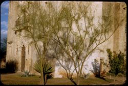
- Description:
- 25 f 9
- Subject:
- National parks & reserves, Balconies, Missions, Mission churches, Mission San José y San Miguel de Aguayo (San Antonio, Tex.), Shrubs, Trees, Stone carvi...
- Series:
- 14-51
- Creator:
- Cushman, Charles W., 1896-1972
- Date Created:
- 1951-12-20
- Genre:
- Identification photographs and Architectural photographs
- Frame Number:
- 16
- County:
- Bexar
- Abstract:
- Little palos verdes perhaps?
- Call Number:
- P05361
- City:
- San Antonio
- Country:
- United States
- State/Province:
- Texas
- Alternate Identifier:
- 1451.16
- Persistent URL:
- http://purl.dlib.indiana.edu/iudl/archives/cushman/P05361
- Holding Location:
- Bloomington - University Archives
Wells Library E460
1320 E 10th St.
Bloomington, IN 47405
Contact at archives@indiana.edu, 812-855-1127
-
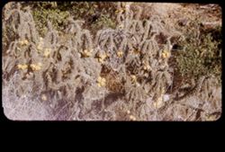
- Description:
- 50 f 8
- Subject:
- Cholla fruit, Fruit, Shrubs, and Cholla
- Series:
- 17-51
- Creator:
- Cushman, Charles W., 1896-1972
- Date Created:
- 1951-12-30
- Genre:
- Identification photographs
- Frame Number:
- 12
- Street Address:
- Texas State Highway 118
- County:
- Jeff Davis and Culberson
- Abstract:
- Cholla along Tex 118 bet. Ft. Davis + Kent..
- Call Number:
- P05468
- City:
- Kent and Fort Davis
- Country:
- United States
- State/Province:
- Texas
- Physical Description:
- masked.
- Alternate Identifier:
- 1751.12
- Persistent URL:
- http://purl.dlib.indiana.edu/iudl/archives/cushman/P05468
- Holding Location:
- Bloomington - University Archives
Wells Library E460
1320 E 10th St.
Bloomington, IN 47405
Contact at archives@indiana.edu, 812-855-1127
-
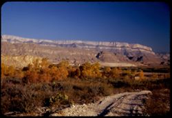
- Description:
- 25 f 6.3 Pola
- Subject:
- Reserva de la Biosfera Santa Elena-Sierra del Carmen (Mexico), Cliffs, Dirt roads, Trails & paths, Trees, Mountains, National parks & reserves, Hills...
- Series:
- 16-51
- Creator:
- Cushman, Charles W., 1896-1972
- Date Created:
- 1951-12-27
- Genre:
- Landscape photographs
- Frame Number:
- 19
- County:
- Brewster
- Abstract:
- Across to Boquillas.
- Call Number:
- P05438
- Country:
- United States and Mexico
- State/Province:
- Texas
- Alternate Identifier:
- 1651.19
- Persistent URL:
- http://purl.dlib.indiana.edu/iudl/archives/cushman/P05438
- Holding Location:
- Bloomington - University Archives
Wells Library E460
1320 E 10th St.
Bloomington, IN 47405
Contact at archives@indiana.edu, 812-855-1127
-
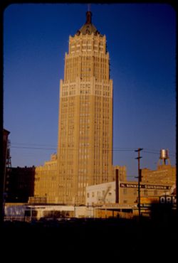
- Description:
- 25 f 11
- Subject:
- Towers, Electric lines, Fire escapes, Skyscrapers, Shadows, Signs (Notices), Buildings, Transit Tower (San Antonio, Tex.), Windows, Utility poles, Smokestack...
- Series:
- 14-51
- Creator:
- Cushman, Charles W., 1896-1972
- Date Created:
- 1951-12-21
- Genre:
- Architectural photographs
- Frame Number:
- 24
- County:
- Bexar
- Abstract:
- Transit Tower
- Call Number:
- P05369
- City:
- San Antonio
- Country:
- United States
- State/Province:
- Texas
- Alternate Identifier:
- 1451.24
- Persistent URL:
- http://purl.dlib.indiana.edu/iudl/archives/cushman/P05369
- Holding Location:
- Bloomington - University Archives
Wells Library E460
1320 E 10th St.
Bloomington, IN 47405
Contact at archives@indiana.edu, 812-855-1127
- « Previous
- Next »
- 1
- 2
- 3