
Search Constraints
You searched for:
Campus
IUB
Remove constraint Campus: IUB
Pages
0-99 pages
Remove constraint Pages: 0-99 pages
Subject
Shrubs
Remove constraint Subject: Shrubs
State/Province
Oregon
Remove constraint State/Province: Oregon
« Previous |
1 - 20 of 45
|
Next »
Search Results
-
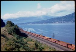
- Description:
- 50 f 6.3
- Subject:
- Railroad freight cars, Union Pacific Railroad Company, Columbia River, Railroad cars, Railroad tracks, Mountains, Utility poles, Electric lines, Trees, Cloud...
- Series:
- 25-60
- Creator:
- Cushman, Charles W., 1896-1972
- Date Created:
- 1960-09-25
- Genre:
- Landscape photographs
- Frame Number:
- 10
- County:
- Hood River
- Abstract:
- Cloud mass above Columbia 16 mi w. of H.R.
- Call Number:
- P11698
- City:
- Hood River
- Country:
- United States
- State/Province:
- Oregon
- Alternate Identifier:
- 2560.10
- Persistent URL:
- http://purl.dlib.indiana.edu/iudl/archives/cushman/P11698
- Holding Location:
- Bloomington - University Archives
Wells Library E460
1320 E 10th St.
Bloomington, IN 47405
Contact at archives@indiana.edu, 812-855-1127
-
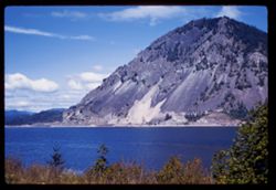
- Description:
- 50 f 8 sl
- Subject:
- Columbia River, Trees, Tree limbs, Mountains, Shrubs, Clouds, and Rivers
- Series:
- 25-60
- Creator:
- Cushman, Charles W., 1896-1972
- Date Created:
- 1960-09-25
- Genre:
- Landscape photographs
- Frame Number:
- 9
- County:
- Hood River
- Abstract:
- Columbia, 12 mi west of Hood River
- Call Number:
- P11697
- City:
- Hood River
- Country:
- United States
- State/Province:
- Oregon
- Alternate Identifier:
- 2560.9
- Persistent URL:
- http://purl.dlib.indiana.edu/iudl/archives/cushman/P11697
- Holding Location:
- Bloomington - University Archives
Wells Library E460
1320 E 10th St.
Bloomington, IN 47405
Contact at archives@indiana.edu, 812-855-1127
-
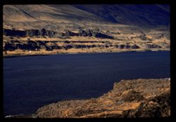
- Description:
- 100 f 6.3 tl
- Subject:
- Rocks, Columbia River, Cliffs, Shadows, Shrubs, Hills, and Rivers
- Series:
- 25-60
- Creator:
- Cushman, Charles W., 1896-1972
- Date Created:
- 1960-09-24
- Genre:
- Landscape photographs
- Frame Number:
- 3
- County:
- Sherman
- Abstract:
- Up river
- Call Number:
- P11691
- City:
- Rufus
- Country:
- United States
- State/Province:
- Oregon
- Alternate Identifier:
- 2560.3
- Persistent URL:
- http://purl.dlib.indiana.edu/iudl/archives/cushman/P11691
- Holding Location:
- Bloomington - University Archives
Wells Library E460
1320 E 10th St.
Bloomington, IN 47405
Contact at archives@indiana.edu, 812-855-1127
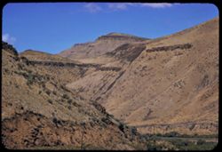
-
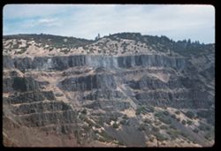
- Description:
- 100 f 6.3 tl
- Subject:
- Columbia River, Cliffs, Columbia River Palisades, Mountains, Shrubs, Columbia Palisades, and Rock formations
- Series:
- 24-60
- Creator:
- Cushman, Charles W., 1896-1972
- Date Created:
- 1960-09-19
- Genre:
- Landscape photographs
- Frame Number:
- 12
- County:
- Wasco
- Abstract:
- Palisades on right bank
- Call Number:
- P11666
- City:
- Rowena
- Country:
- United States
- State/Province:
- Oregon
- Alternate Identifier:
- 2460.12
- Persistent URL:
- http://purl.dlib.indiana.edu/iudl/archives/cushman/P11666
- Holding Location:
- Bloomington - University Archives
Wells Library E460
1320 E 10th St.
Bloomington, IN 47405
Contact at archives@indiana.edu, 812-855-1127
-
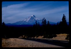
- Description:
- 100 f 11 tl
- Subject:
- Forests, Roads, Dirt, Mountains, Shrubs, Snow, Trees, and Hood, Mount (Or.)
- Series:
- 24-60
- Creator:
- Cushman, Charles W., 1896-1972
- Date Created:
- 1960-09-17
- Genre:
- Landscape photographs
- Frame Number:
- 4
- County:
- Clackamas
- Abstract:
- Mt. Hood from south
- Call Number:
- P11659
- Country:
- United States
- State/Province:
- Oregon
- Alternate Identifier:
- 2460.4
- Persistent URL:
- http://purl.dlib.indiana.edu/iudl/archives/cushman/P11659
- Holding Location:
- Bloomington - University Archives
Wells Library E460
1320 E 10th St.
Bloomington, IN 47405
Contact at archives@indiana.edu, 812-855-1127
-
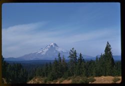
- Description:
- 100 f 9 tl
- Subject:
- Snow, Cascade Range, Trees, Mountains, Hood, Mount (Or.), Shrubs, Forests, and Hills
- Series:
- 24-60
- Creator:
- Cushman, Charles W., 1896-1972
- Date Created:
- 1960-09-17
- Genre:
- Landscape photographs
- Frame Number:
- 3
- County:
- Clackamas
- Abstract:
- Mt. Hood from south
- Call Number:
- P11658
- Country:
- United States
- State/Province:
- Oregon
- Alternate Identifier:
- 2460.3
- Persistent URL:
- http://purl.dlib.indiana.edu/iudl/archives/cushman/P11658
- Holding Location:
- Bloomington - University Archives
Wells Library E460
1320 E 10th St.
Bloomington, IN 47405
Contact at archives@indiana.edu, 812-855-1127
-
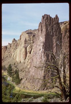
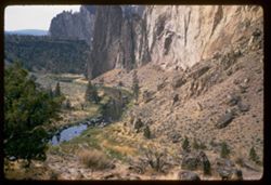
- Description:
- 50 f 8 sl
- Subject:
- Crooked River (Or.), Cliffs, Trees, Buttes, Tree limbs, Rock formations, Smith Rock (Or.), Rivers, and Shrubs
- Series:
- 23-60
- Creator:
- Cushman, Charles W., 1896-1972
- Date Created:
- 1960-09-17
- Genre:
- Landscape photographs
- Frame Number:
- 35
- County:
- Deschutes
- Abstract:
- Smiths Rocks above Crooked river
- Call Number:
- P11654
- Country:
- United States
- State/Province:
- Oregon
- Alternate Identifier:
- 2360.35
- Persistent URL:
- http://purl.dlib.indiana.edu/iudl/archives/cushman/P11654
- Holding Location:
- Bloomington - University Archives
Wells Library E460
1320 E 10th St.
Bloomington, IN 47405
Contact at archives@indiana.edu, 812-855-1127
-
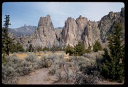
- Description:
- 50 f 9
- Subject:
- Cliffs, Trees, Buttes, Mountains, Rock formations, Smith Rock (Or.), and Shrubs
- Series:
- 23-60
- Creator:
- Cushman, Charles W., 1896-1972
- Date Created:
- 1960-09-17
- Genre:
- Landscape photographs
- Frame Number:
- 33
- County:
- Deschutes
- Abstract:
- Broad view of 29 + 30
- Call Number:
- P11652
- Country:
- United States
- State/Province:
- Oregon
- Alternate Identifier:
- 2360.33
- Persistent URL:
- http://purl.dlib.indiana.edu/iudl/archives/cushman/P11652
- Holding Location:
- Bloomington - University Archives
Wells Library E460
1320 E 10th St.
Bloomington, IN 47405
Contact at archives@indiana.edu, 812-855-1127
-
- Description:
- 50 f 6.3 sl
- Subject:
- Cliffs, Trees, Boulders, Buttes, Mountains, Shrubs, Smith Rock (Or.), Streams, and Rock formations
- Series:
- 23-60
- Creator:
- Cushman, Charles W., 1896-1972
- Date Created:
- 1960-09-17
- Genre:
- Landscape photographs
- Frame Number:
- 32
- County:
- Deschutes
- Abstract:
- Looking down into creek
- Call Number:
- P11651
- Country:
- United States
- State/Province:
- Oregon
- Alternate Identifier:
- 2360.32
- Persistent URL:
- http://purl.dlib.indiana.edu/iudl/archives/cushman/P11651
- Holding Location:
- Bloomington - University Archives
Wells Library E460
1320 E 10th St.
Bloomington, IN 47405
Contact at archives@indiana.edu, 812-855-1127
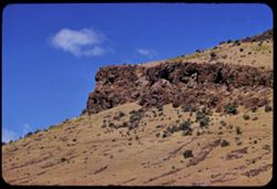
-
- Description:
- 100 f 8 tl
- Subject:
- Cliffs, Buttes, Mountains, Rock formations, Smith Rock (Or.), and Shrubs
- Series:
- 23-60
- Creator:
- Cushman, Charles W., 1896-1972
- Date Created:
- 1960-09-17
- Genre:
- Landscape photographs and Identification photographs
- Frame Number:
- 29
- County:
- Deschutes
- Call Number:
- P11649
- City:
- Terrebonne
- Country:
- United States
- State/Province:
- Oregon
- Alternate Identifier:
- 2360.29
- Persistent URL:
- http://purl.dlib.indiana.edu/iudl/archives/cushman/P11649
- Holding Location:
- Bloomington - University Archives
Wells Library E460
1320 E 10th St.
Bloomington, IN 47405
Contact at archives@indiana.edu, 812-855-1127
-
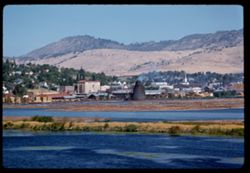
- Description:
- 100 f 5.6 tl
- Subject:
- Sandbars, Industrial facilities, Hills, Bodies of water, Mountains, Shrubs, Buildings, Islands, and Houses
- Series:
- 23-60
- Creator:
- Cushman, Charles W., 1896-1972
- Date Created:
- 1960-09-16
- Genre:
- Landscape photographs, Cityscape photographs, and Views
- Frame Number:
- 10
- County:
- Klamath
- Abstract:
- Klamath Falls from south
- Call Number:
- P11632
- City:
- Klamath Falls
- Country:
- United States
- State/Province:
- Oregon
- Alternate Identifier:
- 2360.10
- Persistent URL:
- http://purl.dlib.indiana.edu/iudl/archives/cushman/P11632
- Holding Location:
- Bloomington - University Archives
Wells Library E460
1320 E 10th St.
Bloomington, IN 47405
Contact at archives@indiana.edu, 812-855-1127
-
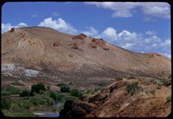
- Description:
- 100 f 8 TL
- Subject:
- Rocks, Shrubs, Clouds, Hills, Malheur River (Or.), Rivers, and Rock formations
- Series:
- 11-58
- Creator:
- Cushman, Charles W., 1896-1972
- Date Created:
- 1958-06-14
- Genre:
- Landscape photographs
- Frame Number:
- 15
- County:
- Malheur and Harney
- Abstract:
- [Nobs]
- Call Number:
- P09990
- City:
- Burns
- Country:
- United States
- State/Province:
- Oregon
- Alternate Identifier:
- 1158.15
- Persistent URL:
- http://purl.dlib.indiana.edu/iudl/archives/cushman/P09990
- Holding Location:
- Bloomington - University Archives
Wells Library E460
1320 E 10th St.
Bloomington, IN 47405
Contact at archives@indiana.edu, 812-855-1127
-
- Description:
- 100 f 8 TL
- Subject:
- Rocks, Trees, Rock formations, Clouds, Hills, Malheur River (Or.), Rivers, and Shrubs
- Series:
- 11-58
- Creator:
- Cushman, Charles W., 1896-1972
- Date Created:
- 1958-06-14
- Genre:
- Landscape photographs
- Frame Number:
- 14
- County:
- Malheur and Harney
- Abstract:
- [P] 88 east of Burns
- Call Number:
- P09989
- City:
- Burns
- Country:
- United States
- State/Province:
- Oregon
- Alternate Identifier:
- 1158.14
- Persistent URL:
- http://purl.dlib.indiana.edu/iudl/archives/cushman/P09989
- Holding Location:
- Bloomington - University Archives
Wells Library E460
1320 E 10th St.
Bloomington, IN 47405
Contact at archives@indiana.edu, 812-855-1127
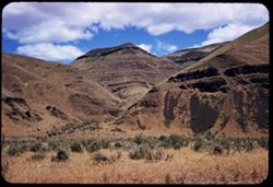
-
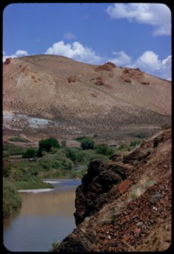
- Description:
- 100 f 6.3 SL
- Subject:
- Mountains, Shrubs, Rock formations, Malheur River (Or.), and Clouds
- Series:
- 11-58
- Creator:
- Cushman, Charles W., 1896-1972
- Date Created:
- 1958-06-14
- Genre:
- Landscape photographs
- Frame Number:
- 11
- County:
- Malheur
- Abstract:
- Tip of nearby
- Call Number:
- P09986
- Country:
- United States
- State/Province:
- Oregon
- Alternate Identifier:
- 1158.11
- Persistent URL:
- http://purl.dlib.indiana.edu/iudl/archives/cushman/P09986
- Holding Location:
- Bloomington - University Archives
Wells Library E460
1320 E 10th St.
Bloomington, IN 47405
Contact at archives@indiana.edu, 812-855-1127
-
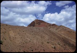
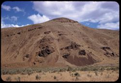
- Description:
- 100 f 6.3 SL
- Subject:
- Rocks, Canyons, Roads, Malheur Canyon (Or.), Volcanic rock, Mountains, Shrubs, and Clouds
- Series:
- 11-58
- Creator:
- Cushman, Charles W., 1896-1972
- Date Created:
- 1958-06-14
- Genre:
- Landscape photographs
- Frame Number:
- 10
- County:
- Malheur and Harney
- Abstract:
- Great red hunk
- Call Number:
- P09985
- City:
- Burns
- Country:
- United States
- State/Province:
- Oregon
- Alternate Identifier:
- 1158.10
- Persistent URL:
- http://purl.dlib.indiana.edu/iudl/archives/cushman/P09985
- Holding Location:
- Bloomington - University Archives
Wells Library E460
1320 E 10th St.
Bloomington, IN 47405
Contact at archives@indiana.edu, 812-855-1127
-
- Description:
- 100 f 6.3 SL
- Subject:
- Rocks, Shrubs, Clouds, and Hills
- Series:
- 11-58
- Creator:
- Cushman, Charles W., 1896-1972
- Date Created:
- 1958-06-14
- Genre:
- Landscape photographs
- Frame Number:
- 7
- Street Address:
- United States Highway 20
- County:
- Malheur
- Abstract:
- On south sid
- Call Number:
- P09982
- Country:
- United States
- State/Province:
- Oregon
- Alternate Identifier:
- 1158.7
- Persistent URL:
- http://purl.dlib.indiana.edu/iudl/archives/cushman/P09982
- Holding Location:
- Bloomington - University Archives
Wells Library E460
1320 E 10th St.
Bloomington, IN 47405
Contact at archives@indiana.edu, 812-855-1127
-
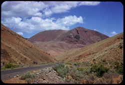
- Description:
- 100 f 6.3 SL
- Subject:
- Grasses, Volcanic rock, Shrubs, Clouds, and Hills
- Series:
- 11-58
- Creator:
- Cushman, Charles W., 1896-1972
- Date Created:
- 1958-06-14
- Genre:
- Landscape photographs
- Frame Number:
- 6
- Street Address:
- United States Highway 20
- County:
- Malheur
- Abstract:
- Great brown lava
- Call Number:
- P09981
- Country:
- United States
- State/Province:
- Oregon
- Alternate Identifier:
- 1158.6
- Persistent URL:
- http://purl.dlib.indiana.edu/iudl/archives/cushman/P09981
- Holding Location:
- Bloomington - University Archives
Wells Library E460
1320 E 10th St.
Bloomington, IN 47405
Contact at archives@indiana.edu, 812-855-1127
-
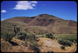
- Description:
- 100 f 6.3 SL
- Subject:
- Grasses, Volcanic rock, Mountains, Shrubs, and Clouds
- Series:
- 11-58
- Creator:
- Cushman, Charles W., 1896-1972
- Date Created:
- 1958-06-14
- Genre:
- Landscape photographs
- Frame Number:
- 5
- Street Address:
- United States Highway 20
- County:
- Malheur
- Abstract:
- Great brown lava
- Call Number:
- P09980
- Country:
- United States
- State/Province:
- Oregon
- Alternate Identifier:
- 1158.5
- Persistent URL:
- http://purl.dlib.indiana.edu/iudl/archives/cushman/P09980
- Holding Location:
- Bloomington - University Archives
Wells Library E460
1320 E 10th St.
Bloomington, IN 47405
Contact at archives@indiana.edu, 812-855-1127
-
- Description:
- 100 f 8 TL
- Subject:
- Canyons, Roads, Shrubs, Trees, and Malheur River (Or.)
- Series:
- 11-58
- Creator:
- Cushman, Charles W., 1896-1972
- Date Created:
- 1958-06-14
- Genre:
- Landscape photographs
- Frame Number:
- 4
- County:
- Malheur
- Abstract:
- View back up Malheur
- Call Number:
- P09979
- Country:
- United States
- State/Province:
- Oregon
- Alternate Identifier:
- 1158.4
- Persistent URL:
- http://purl.dlib.indiana.edu/iudl/archives/cushman/P09979
- Holding Location:
- Bloomington - University Archives
Wells Library E460
1320 E 10th St.
Bloomington, IN 47405
Contact at archives@indiana.edu, 812-855-1127
-
- Description:
- 100 f 7 TL
- Subject:
- Volcanic rock, Rock formations, Clouds, Malheur River (Or.), and Shrubs
- Series:
- 11-58
- Creator:
- Cushman, Charles W., 1896-1972
- Date Created:
- 1958-06-14
- Genre:
- Landscape photographs
- Frame Number:
- 1
- County:
- Malheur
- Abstract:
- Lava headland above bend in Malheur river
- Call Number:
- P09976
- Country:
- United States
- State/Province:
- Oregon
- Alternate Identifier:
- 1158.1
- Persistent URL:
- http://purl.dlib.indiana.edu/iudl/archives/cushman/P09976
- Holding Location:
- Bloomington - University Archives
Wells Library E460
1320 E 10th St.
Bloomington, IN 47405
Contact at archives@indiana.edu, 812-855-1127
- « Previous
- Next »
- 1
- 2
- 3