
Search Constraints
You searched for:
Campus
IUB
Remove constraint Campus: IUB
Pages
0-99 pages
Remove constraint Pages: 0-99 pages
State/Province
Utah
Remove constraint State/Province: Utah
« Previous |
1 - 100 of 368
|
Next »
Search Results
-
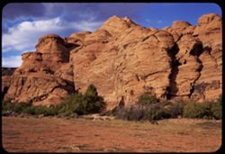
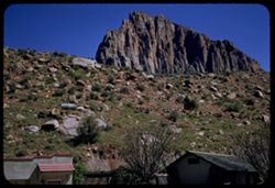
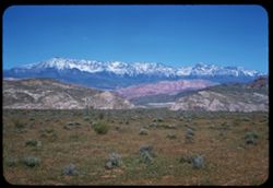
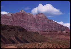
- Description:
- ?
- Subject:
- Canyons, Snow Canyon (Washington County, Utah), Plants, Rock formations, and Clouds
- Series:
- 8-58
- Creator:
- Cushman, Charles W., 1896-1972
- Date Created:
- 1958-04-28
- Genre:
- Landscape photographs
- Frame Number:
- 5
- County:
- Washington
- Abstract:
- big rock - Snow's Canyon
- Call Number:
- P09893
- City:
- Saint George
- Country:
- United States
- State/Province:
- Utah
- Alternate Identifier:
- 858.5
- Persistent URL:
- http://purl.dlib.indiana.edu/iudl/archives/cushman/P09893
- Holding Location:
- Bloomington - University Archives
Wells Library E460
1320 E 10th St.
Bloomington, IN 47405
Contact at archives@indiana.edu, 812-855-1127
-
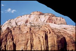
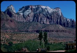
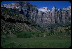
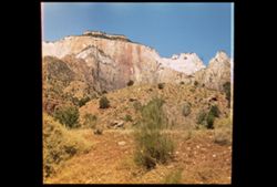
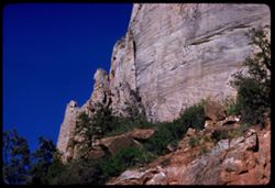
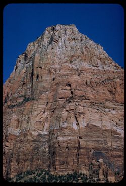
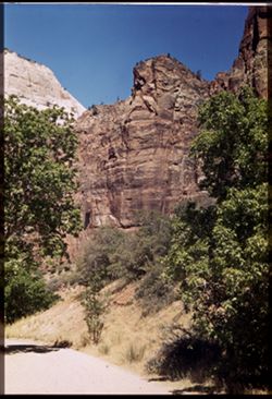
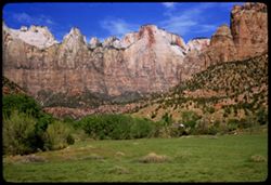
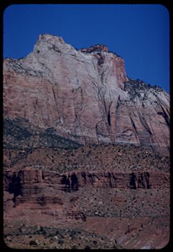
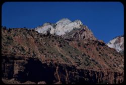
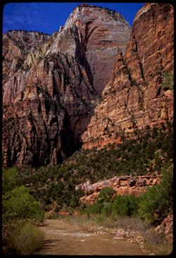
- Subject:
- Cliffs, Trees, Mountains, National parks & reserves, Zion National Park (Utah), Clouds, East Temple (Utah), and Shrubs
- Series:
- 11-40
- Creator:
- Cushman, Charles W., 1896-1972
- Date Created:
- 1940-07-11
- Genre:
- Landscape photographs
- Frame Number:
- 11
- County:
- Washington
- Abstract:
- Zion's East Temple from tunnel window.
- Call Number:
- P01971
- Country:
- United States
- State/Province:
- Utah
- Physical Description:
- Image was originally mounted in a glass enclosure. Before digitization, the image was removed and placed in a Wess Plastic, Inc. brand, 2" x 2", pl...
- Alternate Identifier:
- 1140.11
- Persistent URL:
- http://purl.dlib.indiana.edu/iudl/archives/cushman/P01971
- Holding Location:
- Bloomington - University Archives
Wells Library E460
1320 E 10th St.
Bloomington, IN 47405
Contact at archives@indiana.edu, 812-855-1127
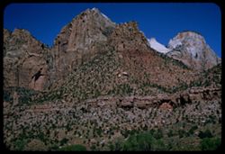
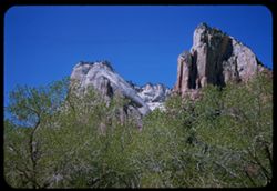
-
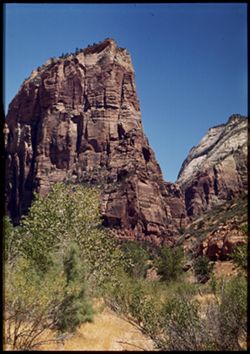
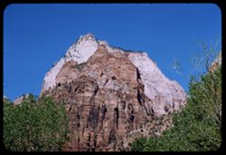
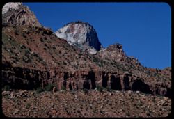
- Subject:
- Angels Landing (Utah), Cliffs, Trees, Virgin River, Mountains, Shrubs, Zion National Park (Utah), and National parks & reserves
- Series:
- 11-40
- Creator:
- Cushman, Charles W., 1896-1972
- Date Created:
- 1940-07-11
- Genre:
- Landscape photographs
- Frame Number:
- 3
- County:
- Washington
- Abstract:
- Angel's Landing. View is north from river bank.
- Call Number:
- P01963
- Country:
- United States
- State/Province:
- Utah
- Physical Description:
- Image was originally mounted in a glass enclosure. Before digitization, the image was removed and placed in a Wess Plastic, Inc. brand, 2" x 2", pl...
- Alternate Identifier:
- 1140.3
- Persistent URL:
- http://purl.dlib.indiana.edu/iudl/archives/cushman/P01963
- Holding Location:
- Bloomington - University Archives
Wells Library E460
1320 E 10th St.
Bloomington, IN 47405
Contact at archives@indiana.edu, 812-855-1127
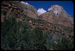
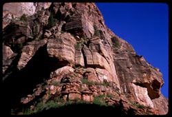
-
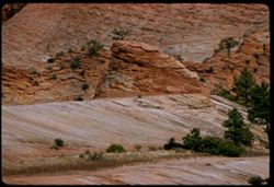
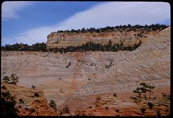
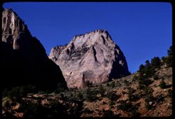
- Description:
- 100 f 5.6 tl
- Subject:
- Mesas, Rock formations, Zion National Park (Utah), Trees, and National parks & reserves
- Series:
- 7-58
- Creator:
- Cushman, Charles W., 1896-1972
- Date Created:
- 1958-04-27
- Genre:
- Landscape photographs
- Frame Number:
- 7
- County:
- Washington
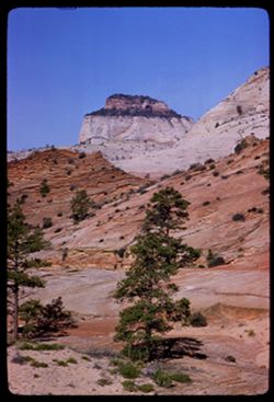
- Abstract:
- A small cap
- Call Number:
- P09861
- Country:
- United States
- State/Province:
- Utah
- Alternate Identifier:
- 758.7
- Persistent URL:
- http://purl.dlib.indiana.edu/iudl/archives/cushman/P09861
- Holding Location:
- Bloomington - University Archives
Wells Library E460
1320 E 10th St.
Bloomington, IN 47405
Contact at archives@indiana.edu, 812-855-1127
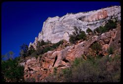
-
- Description:
- 100 f 8 tl
- Subject:
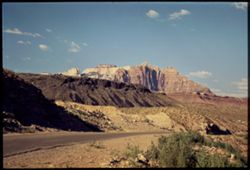
- Eagle's Nest Trading Post (Washington County, Utah), Cliffs, Trees, Mountains, National parks & reserves, Zion National Park (Utah), West Temple (Uta...
- Series:
- 4-58
- Creator:
- Cushman, Charles W., 1896-1972
- Date Created:
- 1958-04-26
- Genre:
- Landscape photographs
- Frame Number:
- 8
- County:
- Washington
- Abstract:
- West Temple Rock ridge above Eagle's Nest Trading Post
- Call Number:
- P09760
- Country:
- United States
- State/Province:
- Utah
- Alternate Identifier:
- 458.8
- Persistent URL:
- http://purl.dlib.indiana.edu/iudl/archives/cushman/P09760
- Holding Location:
- Bloomington - University Archives
Wells Library E460
1320 E 10th St.
Bloomington, IN 47405
Contact at archives@indiana.edu, 812-855-1127
-
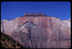
- Subject:
- Cliffs, Trees, Mountains, Shrubs, Zion National Park (Utah), Temple of Sinawava (Utah), and National parks & reserves
- Series:
- 11-40
- Creator:
- Cushman, Charles W., 1896-1972
- Date Created:
- 1940-07-11
- Genre:
- Landscape photographs
- Frame Number:
- 9
- County:
- Washington
- Abstract:
- Temple of Sinawara - the Attar.
- Call Number:
- P01969
- Country:
- United States
- State/Province:
- Utah
- Alternate Identifier:
- 1140.9
- Persistent URL:
- http://purl.dlib.indiana.edu/iudl/archives/cushman/P01969
- Holding Location:
- Bloomington - University Archives
Wells Library E460
1320 E 10th St.
Bloomington, IN 47405
Contact at archives@indiana.edu, 812-855-1127
-
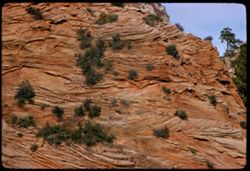
- Description:
- 100 f 6.3 tl
- Subject:
- Trees, National parks & reserves, Zion National Park (Utah), Shrubs, and Rock formations
- Series:
- 7-58
- Creator:
- Cushman, Charles W., 1896-1972
- Date Created:
- 1958-04-27
- Genre:
- Landscape photographs
- Frame Number:
- 8
- County:
- Washington
- Abstract:
- Scroll-work on side of a large reddish rock
- Call Number:
- P09862
- Country:
- United States
- State/Province:
- Utah
- Alternate Identifier:
- 758.8
- Persistent URL:
- http://purl.dlib.indiana.edu/iudl/archives/cushman/P09862
- Holding Location:
- Bloomington - University Archives
Wells Library E460
1320 E 10th St.
Bloomington, IN 47405
Contact at archives@indiana.edu, 812-855-1127
-
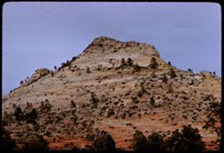
- Description:
- 100 f 8 tl
- Subject:
- Trees, Mountains, Rock formations, Zion National Park (Utah), and National parks & reserves
- Series:
- 7-58
- Creator:
- Cushman, Charles W., 1896-1972
- Date Created:
- 1958-04-27
- Genre:
- Landscape photographs
- Frame Number:
- 9
- County:
- Washington
- Abstract:
- Top knot of light gray-green rock
- Call Number:
- P09863
- Country:
- United States
- State/Province:
- Utah
- Alternate Identifier:
- 758.9
- Persistent URL:
- http://purl.dlib.indiana.edu/iudl/archives/cushman/P09863
- Holding Location:
- Bloomington - University Archives
Wells Library E460
1320 E 10th St.
Bloomington, IN 47405
Contact at archives@indiana.edu, 812-855-1127
-
- Description:
- 100 f 6.3 tl
- Subject:
- Mesas, Rock formations, Zion National Park (Utah), Clouds, Trees, and National parks & reserves
- Series:
- 7-58
- Creator:
- Cushman, Charles W., 1896-1972
- Date Created:
- 1958-04-27
- Genre:
- Landscape photographs
- Frame Number:
- 6
- County:
- Washington
- Abstract:
- In same vicinity
- Call Number:
- P09860
- Country:
- United States
- State/Province:
- Utah
- Alternate Identifier:
- 758.6
- Persistent URL:
- http://purl.dlib.indiana.edu/iudl/archives/cushman/P09860
- Holding Location:
- Bloomington - University Archives
Wells Library E460
1320 E 10th St.
Bloomington, IN 47405
Contact at archives@indiana.edu, 812-855-1127
-
- Description:
- 100 f 6.3 sl
- Subject:
- National parks & reserves, Zion National Park (Utah), Cliffs, Trees, and Rock formations
- Series:
- 5-58
- Creator:
- Cushman, Charles W., 1896-1972
- Date Created:
- 1958-04-26
- Genre:
- Landscape photographs
- Frame Number:
- 2
- County:
- Washington
- Abstract:
- Gargoyles ?
- Call Number:
- P09792
- Country:
- United States
- State/Province:
- Utah
- Alternate Identifier:
- 558.2
- Persistent URL:
- http://purl.dlib.indiana.edu/iudl/archives/cushman/P09792
- Holding Location:
- Bloomington - University Archives
Wells Library E460
1320 E 10th St.
Bloomington, IN 47405
Contact at archives@indiana.edu, 812-855-1127
-
- Description:
- 100 f 6.3 sl
- Subject:
- Rocks, Canyons, Cliffs, National parks & reserves, Zion National Park (Utah), and Plants
- Series:
- 4-58
- Creator:
- Cushman, Charles W., 1896-1972
- Date Created:
- 1958-04-26
- Genre:
- Landscape photographs
- Frame Number:
- 11
- County:
- Washington
- Abstract:
- Inside the Park - west side
- Call Number:
- P09763
- Country:
- United States
- State/Province:
- Utah
- Alternate Identifier:
- 458.11
- Persistent URL:
- http://purl.dlib.indiana.edu/iudl/archives/cushman/P09763
- Holding Location:
- Bloomington - University Archives
Wells Library E460
1320 E 10th St.
Bloomington, IN 47405
Contact at archives@indiana.edu, 812-855-1127
-
- Description:
- 100 f 8 sl
- Subject:
- Rocks, Canyons, Cliffs, Trees, Mountains, National parks & reserves, and Zion National Park (Utah)
- Series:
- 4-58
- Creator:
- Cushman, Charles W., 1896-1972
- Date Created:
- 1958-04-26
- Genre:
- Landscape photographs
- Frame Number:
- 14
- County:
- Washington
- Abstract:
- One of the bee-hives
- Call Number:
- P09766
- Country:
- United States
- State/Province:
- Utah
- Alternate Identifier:
- 458.14
- Persistent URL:
- http://purl.dlib.indiana.edu/iudl/archives/cushman/P09766
- Holding Location:
- Bloomington - University Archives
Wells Library E460
1320 E 10th St.
Bloomington, IN 47405
Contact at archives@indiana.edu, 812-855-1127
-
- Description:
- 100 f 6.3 sl
- Subject:
- National parks & reserves, Meadows, Canyons, Valleys, Zion National Park (Utah), Cliffs, West Temple (Utah), Trees, and Rocks
- Series:
- 4-58
- Creator:
- Cushman, Charles W., 1896-1972
- Date Created:
- 1958-04-26
- Genre:
- Landscape photographs
- Frame Number:
- 12
- County:
- Washington
- Abstract:
- West Temple
- Call Number:
- P09764
- Country:
- United States
- State/Province:
- Utah
- Alternate Identifier:
- 458.12
- Persistent URL:
- http://purl.dlib.indiana.edu/iudl/archives/cushman/P09764
- Holding Location:
- Bloomington - University Archives
Wells Library E460
1320 E 10th St.
Bloomington, IN 47405
Contact at archives@indiana.edu, 812-855-1127
-
- Description:
- 100 f 8 sl
- Subject:
- Rocks, Valleys, Cliffs, Trees, Meadows, Mountains, National parks & reserves, Zion National Park (Utah), West Temple (Utah), and Canyons
- Series:
- 4-58
- Creator:
- Cushman, Charles W., 1896-1972
- Date Created:
- 1958-04-26
- Genre:
- Landscape photographs
- Frame Number:
- 13
- County:
- Washington
- Abstract:
- Ridge next to it
- Call Number:
- P09765
- Country:
- United States
- State/Province:
- Utah
- Alternate Identifier:
- 458.13
- Persistent URL:
- http://purl.dlib.indiana.edu/iudl/archives/cushman/P09765
- Holding Location:
- Bloomington - University Archives
Wells Library E460
1320 E 10th St.
Bloomington, IN 47405
Contact at archives@indiana.edu, 812-855-1127
-
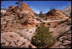
- Description:
- 50 f 6.3 tl
- Subject:
- Pines, Shrubs, Zion National Park (Utah), Mounds (Landforms), National parks & reserves, and Rock formations
- Series:
- 7-58
- Creator:
- Cushman, Charles W., 1896-1972
- Date Created:
- 1958-04-27
- Genre:
- Landscape photographs
- Frame Number:
- 1
- County:
- Washington
- Abstract:
- Reddish double-hump
- Call Number:
- P09855
- Country:
- United States
- State/Province:
- Utah
- Alternate Identifier:
- 758.1
- Persistent URL:
- http://purl.dlib.indiana.edu/iudl/archives/cushman/P09855
- Holding Location:
- Bloomington - University Archives
Wells Library E460
1320 E 10th St.
Bloomington, IN 47405
Contact at archives@indiana.edu, 812-855-1127
-
- Description:
- 50 f 6.3 s
- Subject:
- Mesas, Pines, National parks & reserves, Zion National Park (Utah), and Rock formations
- Series:
- 7-58
- Creator:
- Cushman, Charles W., 1896-1972
- Date Created:
- 1958-04-27
- Genre:
- Landscape photographs
- Frame Number:
- 3
- County:
- Washington
- Abstract:
- Lone pine
- Call Number:
- P09857
- Country:
- United States
- State/Province:
- Utah
- Alternate Identifier:
- 758.3
- Persistent URL:
- http://purl.dlib.indiana.edu/iudl/archives/cushman/P09857
- Holding Location:
- Bloomington - University Archives
Wells Library E460
1320 E 10th St.
Bloomington, IN 47405
Contact at archives@indiana.edu, 812-855-1127
-
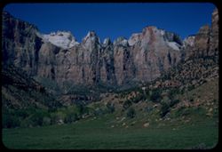
- Subject:
- Rocks, Cliffs, Trees, Mountains, National parks & reserves, Zion National Park (Utah), and Shrubs
- Series:
- 11-40
- Creator:
- Cushman, Charles W., 1896-1972
- Date Created:
- 1940-07-11
- Genre:
- Landscape photographs
- Frame Number:
- 1
- County:
- Washington
- Abstract:
- Zion's West Temple in the Morning Sun
- Call Number:
- P01960
- Country:
- United States
- State/Province:
- Utah
- Physical Description:
- masked. Image was originally mounted in a glass enclosure. Before digitization, the image was removed and placed in a Wess Plastic, Inc. brand, 2" x 2&q...
- Alternate Identifier:
- 1140.00
- Persistent URL:
- http://purl.dlib.indiana.edu/iudl/archives/cushman/P01960
- Holding Location:
- Bloomington - University Archives
Wells Library E460
1320 E 10th St.
Bloomington, IN 47405
Contact at archives@indiana.edu, 812-855-1127
-
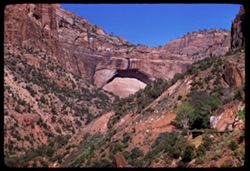
- Description:
- 100 f 6.3 tl
- Subject:
- Rocks, Valleys, Trees, National parks & reserves, Zion National Park (Utah), Great Arch (Utah), Shrubs, and Rock formations
- Series:
- 5-58
- Creator:
- Cushman, Charles W., 1896-1972
- Date Created:
- 1958-04-26
- Genre:
- Landscape photographs
- Frame Number:
- 19
- County:
- Washington
- Abstract:
- The Great Arch
- Call Number:
- P09806
- Country:
- United States
- State/Province:
- Utah
- Alternate Identifier:
- 558.19
- Persistent URL:
- http://purl.dlib.indiana.edu/iudl/archives/cushman/P09806
- Holding Location:
- Bloomington - University Archives
Wells Library E460
1320 E 10th St.
Bloomington, IN 47405
Contact at archives@indiana.edu, 812-855-1127
-
- Subject:
- Cliffs, Trees, Mountains, National parks & reserves, Zion National Park (Utah), and Rock formations
- Series:
- 4-58
- Creator:
- Cushman, Charles W., 1896-1972
- Date Created:
- 1958-04-26
- Genre:
- Landscape photographs
- Frame Number:
- 24
- County:
- Washington
- Call Number:
- P09776
- Country:
- United States
- State/Province:
- Utah
- Alternate Identifier:
- 458.24
- Persistent URL:
- http://purl.dlib.indiana.edu/iudl/archives/cushman/P09776
- Holding Location:
- Bloomington - University Archives
Wells Library E460
1320 E 10th St.
Bloomington, IN 47405
Contact at archives@indiana.edu, 812-855-1127
-
- Description:
- 50 f 8 sl
- Subject:
- Cliffs, Great White Throne (Utah), Shadows, National parks & reserves, Zion National Park (Utah), Plants, and Rock formations
- Series:
- 5-58
- Creator:
- Cushman, Charles W., 1896-1972
- Date Created:
- 1958-04-26
- Genre:
- Landscape photographs
- Frame Number:
- 16
- County:
- Washington
- Abstract:
- Looking up at red rock below Grt Wht Throne
- Call Number:
- P09804
- Country:
- United States
- State/Province:
- Utah
- Alternate Identifier:
- 558.16
- Persistent URL:
- http://purl.dlib.indiana.edu/iudl/archives/cushman/P09804
- Holding Location:
- Bloomington - University Archives
Wells Library E460
1320 E 10th St.
Bloomington, IN 47405
Contact at archives@indiana.edu, 812-855-1127
-
- Description:
- 100 f 6 sl
- Subject:
- Cliffs, Trees, Boulders, National parks & reserves, Zion National Park (Utah), Houses, and Rock formations
- Series:
- 4-58
- Creator:
- Cushman, Charles W., 1896-1972
- Date Created:
- 1958-04-26
- Genre:
- Landscape photographs
- Frame Number:
- 30
- County:
- Washington
- Abstract:
- High rock
- Call Number:
- P09782
- Country:
- United States
- State/Province:
- Utah
- Alternate Identifier:
- 458.30
- Persistent URL:
- http://purl.dlib.indiana.edu/iudl/archives/cushman/P09782
- Holding Location:
- Bloomington - University Archives
Wells Library E460
1320 E 10th St.
Bloomington, IN 47405
Contact at archives@indiana.edu, 812-855-1127
-
- Description:
- 100 f 8 tl
- Subject:
- Rocks, Cliffs, Trees, Shrubs, Zion National Park (Utah), National parks & reserves, and Rock formations
- Series:
- 5-58
- Creator:
- Cushman, Charles W., 1896-1972
- Date Created:
- 1958-04-26
- Genre:
- Landscape photographs
- Frame Number:
- 3
- County:
- Washington
- Abstract:
- Gargoyles ?
- Call Number:
- P09793
- Country:
- United States
- State/Province:
- Utah
- Alternate Identifier:
- 558.3
- Persistent URL:
- http://purl.dlib.indiana.edu/iudl/archives/cushman/P09793
- Holding Location:
- Bloomington - University Archives
Wells Library E460
1320 E 10th St.
Bloomington, IN 47405
Contact at archives@indiana.edu, 812-855-1127
-
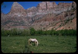
- Description:
- 50 f 11 sl
- Subject:
- Cliffs, Grazing, Horses, Meadows, Mountains, National parks & reserves, and Zion National Park (Utah)
- Series:
- 4-58
- Creator:
- Cushman, Charles W., 1896-1972
- Date Created:
- 1958-04-26
- Genre:
- Landscape photographs
- Frame Number:
- 26
- County:
- Washington
- Abstract:
- Blonde Mare & Mtns
- Call Number:
- P09778
- Country:
- United States
- State/Province:
- Utah
- Alternate Identifier:
- 458.26
- Persistent URL:
- http://purl.dlib.indiana.edu/iudl/archives/cushman/P09778
- Holding Location:
- Bloomington - University Archives
Wells Library E460
1320 E 10th St.
Bloomington, IN 47405
Contact at archives@indiana.edu, 812-855-1127
-
- Description:
- 100 f 6.3 tl
- Subject:
- National parks & reserves, Zion National Park (Utah), Mountains, Trees, Rocks, and Shadows
- Series:
- 5-58
- Creator:
- Cushman, Charles W., 1896-1972
- Date Created:
- 1958-04-26
- Genre:
- Landscape photographs
- Frame Number:
- 20
- County:
- Washington
- Call Number:
- P09807
- Country:
- United States
- State/Province:
- Utah
- Alternate Identifier:
- 558.20
- Persistent URL:
- http://purl.dlib.indiana.edu/iudl/archives/cushman/P09807
- Holding Location:
- Bloomington - University Archives
Wells Library E460
1320 E 10th St.
Bloomington, IN 47405
Contact at archives@indiana.edu, 812-855-1127
-
- Description:
- 100 f 8 tl
- Subject:
- Cliffs, Rock formations, Zion National Park (Utah), and National parks & reserves
- Series:
- 4-58
- Creator:
- Cushman, Charles W., 1896-1972
- Date Created:
- 1958-04-26
- Genre:
- Landscape photographs
- Frame Number:
- 34
- County:
- Washington
- Abstract:
- High point
- Call Number:
- P09786
- Country:
- United States
- State/Province:
- Utah
- Alternate Identifier:
- 458.34
- Persistent URL:
- http://purl.dlib.indiana.edu/iudl/archives/cushman/P09786
- Holding Location:
- Bloomington - University Archives
Wells Library E460
1320 E 10th St.
Bloomington, IN 47405
Contact at archives@indiana.edu, 812-855-1127
-
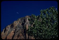
- Description:
- 100 f 8 tl
- Subject:
- Rocks, Cliffs, Trees, Moon, National parks & reserves, and Zion National Park (Utah)
- Series:
- 4-58
- Creator:
- Cushman, Charles W., 1896-1972
- Date Created:
- 1958-04-26
- Genre:
- Landscape photographs
- Frame Number:
- 36
- County:
- Washington
- Abstract:
- Moon & mountain
- Call Number:
- P09788
- Country:
- United States
- State/Province:
- Utah
- Alternate Identifier:
- 458.36
- Persistent URL:
- http://purl.dlib.indiana.edu/iudl/archives/cushman/P09788
- Holding Location:
- Bloomington - University Archives
Wells Library E460
1320 E 10th St.
Bloomington, IN 47405
Contact at archives@indiana.edu, 812-855-1127
-
- Description:
- 100 f 8 tl
- Subject:
- Cliffs, Shadows, National parks & reserves, Zion National Park (Utah), Plants, and Rock formations
- Series:
- 4-58
- Creator:
- Cushman, Charles W., 1896-1972
- Date Created:
- 1958-04-26
- Genre:
- Landscape photographs
- Frame Number:
- 38
- County:
- Washington
- Call Number:
- P09790
- Country:
- United States
- State/Province:
- Utah
- Alternate Identifier:
- 458.38
- Persistent URL:
- http://purl.dlib.indiana.edu/iudl/archives/cushman/P09790
- Holding Location:
- Bloomington - University Archives
Wells Library E460
1320 E 10th St.
Bloomington, IN 47405
Contact at archives@indiana.edu, 812-855-1127
-
- Subject:
- Cliffs, Trees, Mountains, National parks & reserves, and Zion National Park (Utah)
- Series:
- 4-58
- Creator:
- Cushman, Charles W., 1896-1972
- Date Created:
- 1958-04-26
- Genre:
- Landscape photographs
- Frame Number:
- 25
- County:
- Washington
- Call Number:
- P09777
- Country:
- United States
- State/Province:
- Utah
- Alternate Identifier:
- 458.25
- Persistent URL:
- http://purl.dlib.indiana.edu/iudl/archives/cushman/P09777
- Holding Location:
- Bloomington - University Archives
Wells Library E460
1320 E 10th St.
Bloomington, IN 47405
Contact at archives@indiana.edu, 812-855-1127
-
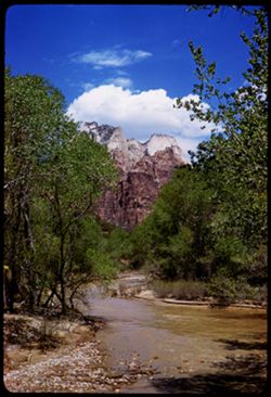
- Subject:
- Weeping Rock (Utah), Mountains, Trees, Temple of Sinawava (Utah), Zion Canyon (Utah), Zion National Park (Utah), Cliffs, Roads, National parks & reserves...
- Series:
- 11-40
- Creator:
- Cushman, Charles W., 1896-1972
- Date Created:
- 1940-07-11/1940-07-12
- Genre:
- Landscape photographs
- Frame Number:
- 2
- County:
- Washington
- Abstract:
- Bed of mountain stream below Weeping Rock.
- Call Number:
- P01962
- Country:
- United States
- State/Province:
- Utah
- Physical Description:
- Image was originally mounted in a glass enclosure. Before digitization, the image was removed and placed in a Wess Plastic, Inc. brand, 2" x 2", pl...
- Alternate Identifier:
- 1140.2
- Persistent URL:
- http://purl.dlib.indiana.edu/iudl/archives/cushman/P01962
- Holding Location:
- Bloomington - University Archives
Wells Library E460
1320 E 10th St.
Bloomington, IN 47405
Contact at archives@indiana.edu, 812-855-1127
-
- Description:
- 100 f 8 tl
- Subject:
- Rocks, Cliffs, Trees, National parks & reserves, and Zion National Park (Utah)
- Series:
- 4-58
- Creator:
- Cushman, Charles W., 1896-1972
- Date Created:
- 1958-04-26
- Genre:
- Landscape photographs
- Frame Number:
- 37
- County:
- Washington
- Call Number:
- P09789
- Country:
- United States
- State/Province:
- Utah
- Alternate Identifier:
- 458.37
- Persistent URL:
- http://purl.dlib.indiana.edu/iudl/archives/cushman/P09789
- Holding Location:
- Bloomington - University Archives
Wells Library E460
1320 E 10th St.
Bloomington, IN 47405
Contact at archives@indiana.edu, 812-855-1127
-
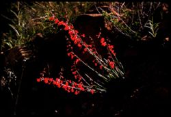
- Description:
- 100 f 8 tl
- Subject:
- Wildflowers, Shadows, Light, Zion National Park (Utah), Zion Canyon (Utah), and National parks & reserves
- Series:
- 7-58
- Creator:
- Cushman, Charles W., 1896-1972
- Date Created:
- 1958-04-28
- Genre:
- Identification photographs
- Frame Number:
- 14
- County:
- Washington
- Abstract:
- Roadside flower
- Call Number:
- P09868
- Country:
- United States
- State/Province:
- Utah
- Alternate Identifier:
- 758.14
- Persistent URL:
- http://purl.dlib.indiana.edu/iudl/archives/cushman/P09868
- Holding Location:
- Bloomington - University Archives
Wells Library E460
1320 E 10th St.
Bloomington, IN 47405
Contact at archives@indiana.edu, 812-855-1127
-
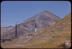
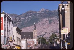
- Description:
- 100 f 8 t
- Subject:
- Rocks, Factories, Mountains, Rock formations, and Smokestacks
- Series:
- 16-58
- Creator:
- Cushman, Charles W., 1896-1972
- Date Created:
- 1958-08-23
- Genre:
- Landscape photographs
- Frame Number:
- 9
- Street Address:
- United States Highway 50 and United States Highway 40
- County:
- Salt Lake
- Abstract:
- Where 50 leaves 40 at entrance to S.L.C
- Call Number:
- P10135
- City:
- Salt Lake City
- Country:
- United States
- State/Province:
- Utah
- Alternate Identifier:
- 1658.9
- Persistent URL:
- http://purl.dlib.indiana.edu/iudl/archives/cushman/P10135
- Holding Location:
- Bloomington - University Archives
Wells Library E460
1320 E 10th St.
Bloomington, IN 47405
Contact at archives@indiana.edu, 812-855-1127
-
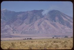
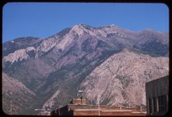
- Description:
- 100 f 6.3 tl hf
- Subject:
- Forest fires, Smoke, Plains, Mountains, and Oquirrh Mountains (Utah)
- Series:
- 16-58
- Creator:
- Cushman, Charles W., 1896-1972
- Date Created:
- 1958-08-23
- Genre:
- Landscape photographs
- Frame Number:
- 3
- Street Address:
- United States Highway 40
- County:
- Salt Lake
- Abstract:
- West slope of Oquirrh Mtn. From US 40, 25 mi. w of Salt Lake City
- Call Number:
- P10129
- City:
- Salt Lake City
- Country:
- United States
- State/Province:
- Utah
- Alternate Identifier:
- 1658.3
- Persistent URL:
- http://purl.dlib.indiana.edu/iudl/archives/cushman/P10129
- Holding Location:
- Bloomington - University Archives
Wells Library E460
1320 E 10th St.
Bloomington, IN 47405
Contact at archives@indiana.edu, 812-855-1127
-
- Description:
- 50 f 11 sl
- Subject:
- Rocks, Canyons, Cliffs, Trees, Meadows, Mountains, National parks & reserves, Zion National Park (Utah), Zion Canyon (Utah), and West Temple (Utah)
- Series:
- 7-58
- Creator:
- Cushman, Charles W., 1896-1972
- Date Created:
- 1958-04-28
- Genre:
- Landscape photographs
- Frame Number:
- 12
- County:
- Washington
- Abstract:
- Wall next to West Temple
- Call Number:
- P09866
- Country:
- United States
- State/Province:
- Utah
- Alternate Identifier:
- 758.12
- Persistent URL:
- http://purl.dlib.indiana.edu/iudl/archives/cushman/P09866
- Holding Location:
- Bloomington - University Archives
Wells Library E460
1320 E 10th St.
Bloomington, IN 47405
Contact at archives@indiana.edu, 812-855-1127
-
- Description:
- 100 f 8 tl
- Subject:
- Rocks, Canyons, Cliffs, National parks & reserves, Zion National Park (Utah), and Plants
- Series:
- 4-58
- Creator:
- Cushman, Charles W., 1896-1972
- Date Created:
- 1958-04-26
- Genre:
- Landscape photographs
- Frame Number:
- 32
- County:
- Washington
- Abstract:
- Up to left from south of entrance
- Call Number:
- P09784
- Country:
- United States
- State/Province:
- Utah
- Alternate Identifier:
- 458.32
- Persistent URL:
- http://purl.dlib.indiana.edu/iudl/archives/cushman/P09784
- Holding Location:
- Bloomington - University Archives
Wells Library E460
1320 E 10th St.
Bloomington, IN 47405
Contact at archives@indiana.edu, 812-855-1127
-
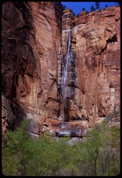
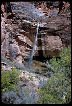
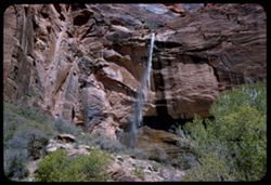
- Description:
- 50 f 6.3 sl
- Subject:
- Sinewava, Temple of (Utah), Cliffs, Waterfalls, Trees, National parks & reserves, and Zion National Park (Utah)
- Series:
- 7-58
- Creator:
- Cushman, Charles W., 1896-1972
- Date Created:
- 1958-04-28
- Genre:
- Landscape photographs
- Frame Number:
- 22
- County:
- Washington
- Abstract:
- Waterfall at Sinewava Temple
- Call Number:
- P09874
- Country:
- United States
- State/Province:
- Utah
- Alternate Identifier:
- 758.22
- Persistent URL:
- http://purl.dlib.indiana.edu/iudl/archives/cushman/P09874
- Holding Location:
- Bloomington - University Archives
Wells Library E460
1320 E 10th St.
Bloomington, IN 47405
Contact at archives@indiana.edu, 812-855-1127
-
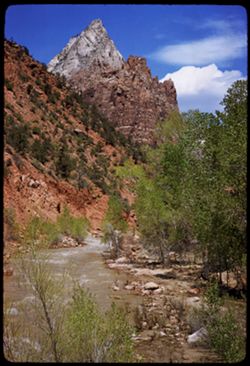
- Subject:
- Rocks, Roads, Mountains, Shrubs, Zion National Park (Utah), Clouds, Zion Canyon (Utah), and National parks & reserves
- Series:
- 10-40
- Creator:
- Cushman, Charles W., 1896-1972
- Date Created:
- 1940-07-10
- Genre:
- Landscape photographs
- Frame Number:
- 19
- County:
- Washington
- Abstract:
- Zion's West Temple, late afternoon.
- Call Number:
- P01941
- Country:
- United States
- State/Province:
- Utah
- Physical Description:
- Image was originally mounted in a glass enclosure. Before digitization, the image was removed and placed in a Wess Plastic, Inc. brand, 2" x 2", pl...
- Alternate Identifier:
- 1040.19
- Persistent URL:
- http://purl.dlib.indiana.edu/iudl/archives/cushman/P01941
- Holding Location:
- Bloomington - University Archives
Wells Library E460
1320 E 10th St.
Bloomington, IN 47405
Contact at archives@indiana.edu, 812-855-1127
-
- Description:
- 100 f 8 tl
- Subject:
- Eagle's Nest Trading Post (Washington County, Utah), Cliffs, Mountains, Rock formations, Zion National Park (Utah), West Temple (Utah), and National park...
- Series:
- 4-58
- Creator:
- Cushman, Charles W., 1896-1972
- Date Created:
- 1958-04-26
- Genre:
- Landscape photographs
- Frame Number:
- 9
- County:
- Washington
- Abstract:
- West Temple Rock ridge above Eagle's Nest Trading Post
- Call Number:
- P09761
- Country:
- United States
- State/Province:
- Utah
- Alternate Identifier:
- 458.9
- Persistent URL:
- http://purl.dlib.indiana.edu/iudl/archives/cushman/P09761
- Holding Location:
- Bloomington - University Archives
Wells Library E460
1320 E 10th St.
Bloomington, IN 47405
Contact at archives@indiana.edu, 812-855-1127
-
- Description:
- 100 f 8 tl
- Subject:
- Cliffs, Mountains, Rock formations, Zion National Park (Utah), West Temple (Utah), Plants, and National parks & reserves
- Series:
- 5-58
- Creator:
- Cushman, Charles W., 1896-1972
- Date Created:
- 1958-04-27
- Genre:
- Landscape photographs
- Frame Number:
- 31
- Street Address:
- Mount Camel Road
- County:
- Washington
- Abstract:
- West Temple
- Call Number:
- P09816
- Country:
- United States
- State/Province:
- Utah
- Alternate Identifier:
- 558.31
- Persistent URL:
- http://purl.dlib.indiana.edu/iudl/archives/cushman/P09816
- Holding Location:
- Bloomington - University Archives
Wells Library E460
1320 E 10th St.
Bloomington, IN 47405
Contact at archives@indiana.edu, 812-855-1127
-
- Description:
- 50 f 11 sl
- Subject:
- Canyons, Cliffs, Trees, Meadows, Mountains, National parks & reserves, Zion National Park (Utah), Zion Canyon (Utah), West Temple (Utah), and Rock format...
- Series:
- 7-58
- Creator:
- Cushman, Charles W., 1896-1972
- Date Created:
- 1958-04-28
- Genre:
- Landscape photographs
- Frame Number:
- 11
- County:
- Washington
- Abstract:
- West Temple from Canyon floor
- Call Number:
- P09865
- Country:
- United States
- State/Province:
- Utah
- Alternate Identifier:
- 758.11
- Persistent URL:
- http://purl.dlib.indiana.edu/iudl/archives/cushman/P09865
- Holding Location:
- Bloomington - University Archives
Wells Library E460
1320 E 10th St.
Bloomington, IN 47405
Contact at archives@indiana.edu, 812-855-1127
-
- Description:
- 50 f 5.6 sl
- Subject:
- National parks & reserves, Zion National Park (Utah), Weeping Rock (Utah), Cliffs, Waterfalls, Trees, and Rocks
- Series:
- 4-58
- Creator:
- Cushman, Charles W., 1896-1972
- Date Created:
- 1958-04-26
- Genre:
- Landscape photographs
- Frame Number:
- 21
- County:
- Washington
- Abstract:
- Weeping Rock
- Call Number:
- P09773
- Country:
- United States
- State/Province:
- Utah
- Alternate Identifier:
- 458.21
- Persistent URL:
- http://purl.dlib.indiana.edu/iudl/archives/cushman/P09773
- Holding Location:
- Bloomington - University Archives
Wells Library E460
1320 E 10th St.
Bloomington, IN 47405
Contact at archives@indiana.edu, 812-855-1127
-
- Description:
- 50 f 5.6 sl
- Subject:
- National parks & reserves, Zion National Park (Utah), Weeping Rock (Utah), Cliffs, Waterfalls, Trees, and Rocks
- Series:
- 4-58
- Creator:
- Cushman, Charles W., 1896-1972
- Date Created:
- 1958-04-26
- Genre:
- Landscape photographs
- Frame Number:
- 20
- County:
- Washington
- Abstract:
- Weeping Rock
- Call Number:
- P09772
- Country:
- United States
- State/Province:
- Utah
- Alternate Identifier:
- 458.20
- Persistent URL:
- http://purl.dlib.indiana.edu/iudl/archives/cushman/P09772
- Holding Location:
- Bloomington - University Archives
Wells Library E460
1320 E 10th St.
Bloomington, IN 47405
Contact at archives@indiana.edu, 812-855-1127
-
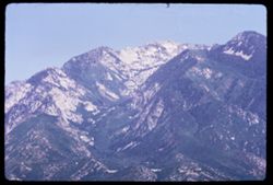
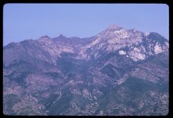
- Description:
- 100 f 11TL
- Subject:
- Wasatch Range (Utah and Idaho) and Mountains
- Series:
- 10-66
- Creator:
- Cushman, Charles W., 1896-1972
- Date Created:
- 1966-06-19
- Genre:
- Landscape photographs
- Frame Number:
- 16
- County:
- Salt Lake
- Abstract:
- Wasatch Mts.
- Call Number:
- P15456
- City:
- Salt Lake City
- Country:
- United States
- State/Province:
- Utah
- Alternate Identifier:
- 1066.16
- Persistent URL:
- http://purl.dlib.indiana.edu/iudl/archives/cushman/P15456
- Holding Location:
- Bloomington - University Archives
Wells Library E460
1320 E 10th St.
Bloomington, IN 47405
Contact at archives@indiana.edu, 812-855-1127
-
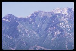
- Description:
- 100 f 11 TL
- Subject:
- Wasatch Range (Utah and Idaho) and Mountains
- Series:
- 10-66
- Creator:
- Cushman, Charles W., 1896-1972
- Date Created:
- 1966-06-19
- Genre:
- Landscape photographs
- Frame Number:
- 15
- County:
- Salt Lake
- Abstract:
- Wasatch Mts.
- Call Number:
- P15455
- City:
- Salt Lake City
- Country:
- United States
- State/Province:
- Utah
- Alternate Identifier:
- 1066.15
- Persistent URL:
- http://purl.dlib.indiana.edu/iudl/archives/cushman/P15455
- Holding Location:
- Bloomington - University Archives
Wells Library E460
1320 E 10th St.
Bloomington, IN 47405
Contact at archives@indiana.edu, 812-855-1127
-
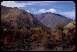
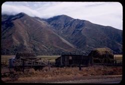
- Description:
- 50 f 8
- Subject:
- Wasatch Range (Utah and Idaho), Grasses, Plains, Croplands, Fences, Clouds, and Mountains
- Series:
- 9-53
- Creator:
- Cushman, Charles W., 1896-1972
- Date Created:
- 1953-10-11
- Genre:
- Landscape photographs
- Frame Number:
- 13
- Street Address:
- United States Highway 50
- County:
- Utah
- Abstract:
- Mtn so. of Mapleton along US 50.
- Call Number:
- P06814
- City:
- Mapleton
- Country:
- United States
- State/Province:
- Utah
- Physical Description:
- Image was originally mounted in a glass enclosure. Before digitization, the image was removed and placed in a Wess Plastic, Inc. brand, 2" x 2", pl...
- Alternate Identifier:
- 953.13
- Persistent URL:
- http://purl.dlib.indiana.edu/iudl/archives/cushman/P06814
- Holding Location:
- Bloomington - University Archives
Wells Library E460
1320 E 10th St.
Bloomington, IN 47405
Contact at archives@indiana.edu, 812-855-1127
-
- Description:
- 100 f 16 TL
- Subject:
- Wasatch Range (Utah and Idaho) and Mountains
- Series:
- 10-66
- Creator:
- Cushman, Charles W., 1896-1972
- Date Created:
- 1966-06-19
- Genre:
- Landscape photographs
- Frame Number:
- 13
- County:
- Salt Lake
- Abstract:
- Wasatch Mtns.
- Call Number:
- P15453
- City:
- Salt Lake City
- Country:
- United States
- State/Province:
- Utah
- Alternate Identifier:
- 1066.13
- Persistent URL:
- http://purl.dlib.indiana.edu/iudl/archives/cushman/P15453
- Holding Location:
- Bloomington - University Archives
Wells Library E460
1320 E 10th St.
Bloomington, IN 47405
Contact at archives@indiana.edu, 812-855-1127
-
- Description:
- 100 f 16 TL
- Subject:
- Wasatch Range (Utah and Idaho), Plains, and Mountains
- Series:
- 10-66
- Creator:
- Cushman, Charles W., 1896-1972
- Date Created:
- 1966-06-19
- Genre:
- Landscape photographs
- Frame Number:
- 14
- County:
- Salt Lake
- Abstract:
- Wasatch Mtns.
- Call Number:
- P15454
- City:
- Salt Lake City
- Country:
- United States
- State/Province:
- Utah
- Alternate Identifier:
- 1066.14
- Persistent URL:
- http://purl.dlib.indiana.edu/iudl/archives/cushman/P15454
- Holding Location:
- Bloomington - University Archives
Wells Library E460
1320 E 10th St.
Bloomington, IN 47405
Contact at archives@indiana.edu, 812-855-1127
-
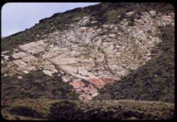
- Description:
- 100 f 5.6 tl
- Subject:
- Volcanic rock, Canyons, Snow Canyon (Washington County, Utah), and Rock formations
- Series:
- 8-58
- Creator:
- Cushman, Charles W., 1896-1972
- Date Created:
- 1958-04-29
- Genre:
- Landscape photographs
- Frame Number:
- 24
- County:
- Washington
- Abstract:
- Sandstone & lava
- Call Number:
- P09909
- City:
- Saint George
- Country:
- United States
- State/Province:
- Utah
- Alternate Identifier:
- 858.24
- Persistent URL:
- http://purl.dlib.indiana.edu/iudl/archives/cushman/P09909
- Holding Location:
- Bloomington - University Archives
Wells Library E460
1320 E 10th St.
Bloomington, IN 47405
Contact at archives@indiana.edu, 812-855-1127
-
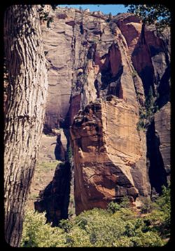
- Description:
- 100 f 5.6 tl
- Subject:
- Sinewava, Temple of (Utah), Cliffs, Trees, Rock formations, Zion National Park (Utah), and National parks & reserves
- Series:
- 5-58
- Creator:
- Cushman, Charles W., 1896-1972
- Date Created:
- 1958-04-26
- Genre:
- Landscape photographs
- Frame Number:
- 7
- County:
- Washington
- Abstract:
- Ledge high above Sinewava Temple
- Call Number:
- P09796
- Country:
- United States
- State/Province:
- Utah
- Alternate Identifier:
- 558.7
- Persistent URL:
- http://purl.dlib.indiana.edu/iudl/archives/cushman/P09796
- Holding Location:
- Bloomington - University Archives
Wells Library E460
1320 E 10th St.
Bloomington, IN 47405
Contact at archives@indiana.edu, 812-855-1127
-
- Description:
- 50 f 9 sl
- Subject:
- Canyons, Trees, Virgin River, National parks & reserves, Zion National Park (Utah), and Rivers
- Series:
- 7-58
- Creator:
- Cushman, Charles W., 1896-1972
- Date Created:
- 1958-04-28
- Genre:
- Landscape photographs
- Frame Number:
- 16
- County:
- Washington
- Abstract:
- Virgin river
- Call Number:
- P09869
- Country:
- United States
- State/Province:
- Utah
- Alternate Identifier:
- 758.16
- Persistent URL:
- http://purl.dlib.indiana.edu/iudl/archives/cushman/P09869
- Holding Location:
- Bloomington - University Archives
Wells Library E460
1320 E 10th St.
Bloomington, IN 47405
Contact at archives@indiana.edu, 812-855-1127
-
- Description:
- 50 f 8 sl
- Subject:
- National parks & reserves, Canyons, Zion National Park (Utah), Virgin River, Cliffs, Shrubs, Trees, and Rivers
- Series:
- 4-58
- Creator:
- Cushman, Charles W., 1896-1972
- Date Created:
- 1958-04-26
- Genre:
- Landscape photographs
- Frame Number:
- 19
- County:
- Washington
- Abstract:
- Looking downstream Virgin river - same spot
- Call Number:
- P09771
- Country:
- United States
- State/Province:
- Utah
- Alternate Identifier:
- 458.19
- Persistent URL:
- http://purl.dlib.indiana.edu/iudl/archives/cushman/P09771
- Holding Location:
- Bloomington - University Archives
Wells Library E460
1320 E 10th St.
Bloomington, IN 47405
Contact at archives@indiana.edu, 812-855-1127
-
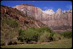
- Subject:
- Rocks, Cliffs, Trees, Virgin River, Mountains, Shrubs, Zion National Park (Utah), Clouds, Zion Canyon (Utah), Rivers, and National parks & reserves
- Series:
- 11-40
- Creator:
- Cushman, Charles W., 1896-1972
- Date Created:
- 1940-07-11/1940-07-12
- Genre:
- Landscape photographs
- Frame Number:
- 5
- County:
- Washington
- Abstract:
- Looking up the Virgin river
- Call Number:
- P01965
- Country:
- United States
- State/Province:
- Utah
- Physical Description:
- Image was originally mounted in a glass enclosure. Before digitization, the image was removed and placed in a Wess Plastic, Inc. brand, 2" x 2", pl...
- Alternate Identifier:
- 1140.5
- Persistent URL:
- http://purl.dlib.indiana.edu/iudl/archives/cushman/P01965
- Holding Location:
- Bloomington - University Archives
Wells Library E460
1320 E 10th St.
Bloomington, IN 47405
Contact at archives@indiana.edu, 812-855-1127
-
- Description:
- 100 f 8 tl
- Subject:
- Rocks, Mesas, Mountains, and Plants
- Series:
- 4-58
- Creator:
- Cushman, Charles W., 1896-1972
- Date Created:
- 1958-04-26
- Genre:
- Landscape photographs
- Frame Number:
- 5
- County:
- Washington
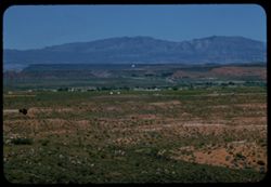
- Abstract:
- Looking back toward St. George
- Call Number:
- P09757
- City:
- Saint George
- Country:
- United States
- State/Province:
- Utah
- Alternate Identifier:
- 458.5
- Persistent URL:
- http://purl.dlib.indiana.edu/iudl/archives/cushman/P09757
- Holding Location:
- Bloomington - University Archives
Wells Library E460
1320 E 10th St.
Bloomington, IN 47405
Contact at archives@indiana.edu, 812-855-1127
-
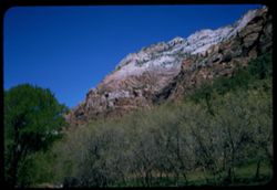
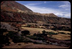
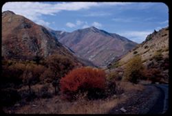
- Description:
- 100 f 8 tl
- Subject:
- Great Arch (Utah), Grasses, Trees, Mountains, National parks & reserves, Zion National Park (Utah), and Rock formations
- Series:
- 5-58
- Creator:
- Cushman, Charles W., 1896-1972
- Date Created:
- 1958-04-27
- Genre:
- Landscape photographs
- Frame Number:
- 33
- Street Address:
- Tunnel Road
- County:
- Washington
- Abstract:
- West from pt. Below Great Arch
- Call Number:
- P09817
- Country:
- United States
- State/Province:
- Utah
- Alternate Identifier:
- 558.33
- Persistent URL:
- http://purl.dlib.indiana.edu/iudl/archives/cushman/P09817
- Holding Location:
- Bloomington - University Archives
Wells Library E460
1320 E 10th St.
Bloomington, IN 47405
Contact at archives@indiana.edu, 812-855-1127
-
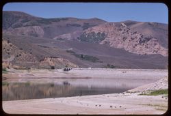
- Description:
- 100 f 5.6 sl
- Subject:
- Reservoirs, Sand, Mountains, Weber River (Utah), Clouds, Hills, Reflections, Rivers, and Echo Reservoir (Utah)
- Series:
- 16-58
- Creator:
- Cushman, Charles W., 1896-1972
- Date Created:
- 1958-08-25
- Genre:
- Landscape photographs
- Frame Number:
- 27
- County:
- Summit
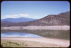
- Abstract:
- West across Echo Reservoir
- Call Number:
- P10153
- Country:
- United States
- State/Province:
- Utah
- Alternate Identifier:
- 1658.27
- Persistent URL:
- http://purl.dlib.indiana.edu/iudl/archives/cushman/P10153
- Holding Location:
- Bloomington - University Archives
Wells Library E460
1320 E 10th St.
Bloomington, IN 47405
Contact at archives@indiana.edu, 812-855-1127
-
- Description:
- 100 f 5.6 tl
- Subject:
- Electric lines, Union Station (Ogden, Utah), Trees, Mountains, Street lights, Hotels, Buildings, and Ogden, Mount (Utah)
- Series:
- 16-58
- Creator:
- Cushman, Charles W., 1896-1972
- Date Created:
- 1958-08-24
- Genre:
- Landscape photographs and Cityscape photographs
- Frame Number:
- 24
- County:
- Weber
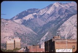
- Abstract:
- Up The draw below Ogden Pk.
- Call Number:
- P10150
- City:
- Ogden
- Country:
- United States
- State/Province:
- Utah
- Alternate Identifier:
- 1658.24
- Persistent URL:
- http://purl.dlib.indiana.edu/iudl/archives/cushman/P10150
- Holding Location:
- Bloomington - University Archives
Wells Library E460
1320 E 10th St.
Bloomington, IN 47405
Contact at archives@indiana.edu, 812-855-1127
-
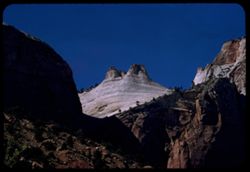
- Description:
- 50 f 9 sl
- Subject:
- Rocks, Angels Landing (Utah), Cliffs, Trees, Virgin River, Mountains, National parks & reserves, Zion National Park (Utah), Clouds, and Rivers
- Series:
- 7-58
- Creator:
- Cushman, Charles W., 1896-1972
- Date Created:
- 1958-04-28
- Genre:
- Landscape photographs
- Frame Number:
- 26
- County:
- Washington
- Abstract:
- View up Virgin toward Angels Landing
- Call Number:
- P09878
- Country:
- United States
- State/Province:
- Utah
- Alternate Identifier:
- 758.26
- Persistent URL:
- http://purl.dlib.indiana.edu/iudl/archives/cushman/P09878
- Holding Location:
- Bloomington - University Archives
Wells Library E460
1320 E 10th St.
Bloomington, IN 47405
Contact at archives@indiana.edu, 812-855-1127
-
- Description:
- 100 f 6.3 sl
- Subject:
- National parks & reserves, Three Patriarchs (Utah), Zion National Park (Utah), Hills, Virgin River, Moroni, Mount (Utah), Mountains, Trees, Rocks, Rivers...
- Series:
- 7-58
- Creator:
- Cushman, Charles W., 1896-1972
- Date Created:
- 1958-04-28
- Genre:
- Landscape photographs
- Frame Number:
- 28
- County:
- Washington
- Abstract:
- View up the Virgin toward one of the Patriarchs and Mt. Moroni
- Call Number:
- P09880
- Country:
- United States
- State/Province:
- Utah
- Alternate Identifier:
- 758.28
- Persistent URL:
- http://purl.dlib.indiana.edu/iudl/archives/cushman/P09880
- Holding Location:
- Bloomington - University Archives
Wells Library E460
1320 E 10th St.
Bloomington, IN 47405
Contact at archives@indiana.edu, 812-855-1127
-
- Description:
- 100 f 8 tl
- Subject:
- Canyons, Cliffs, Mountains, National parks & reserves, Zion National Park (Utah), and Plants
- Series:
- 4-58
- Creator:
- Cushman, Charles W., 1896-1972
- Date Created:
- 1958-04-26
- Genre:
- Landscape photographs
- Frame Number:
- 31
- County:
- Washington
- Abstract:
- Up to left from south of entrance
- Call Number:
- P09783
- Country:
- United States
- State/Province:
- Utah
- Alternate Identifier:
- 458.31
- Persistent URL:
- http://purl.dlib.indiana.edu/iudl/archives/cushman/P09783
- Holding Location:
- Bloomington - University Archives
Wells Library E460
1320 E 10th St.
Bloomington, IN 47405
Contact at archives@indiana.edu, 812-855-1127
-
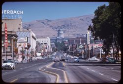
- Description:
- 25 f 8
- Subject:
- Parking, Cities & towns, Streets, Capitol Hill (Salt Lake City, Utah), Automobiles, Mountains, Lawns, Trees, Buildings, and Sculpture
- Series:
- 28-52
- Creator:
- Cushman, Charles W., 1896-1972
- Date Created:
- 1952-11-06
- Genre:
- Landscape photographs and Cityscape photographs
- Frame Number:
- 7
- County:
- Salt Lake
- Abstract:
- View SE from Capitol late aft.
- Call Number:
- P06491
- City:
- Salt Lake City
- Country:
- United States
- State/Province:
- Utah
- Alternate Identifier:
- 2852.7
- Persistent URL:
- http://purl.dlib.indiana.edu/iudl/archives/cushman/P06491
- Holding Location:
- Bloomington - University Archives
Wells Library E460
1320 E 10th St.
Bloomington, IN 47405
Contact at archives@indiana.edu, 812-855-1127
-
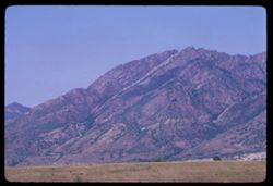
- Description:
- 100 f 5.6 sl
- Subject:
- Snow, Plains, Mountains, Plants, and Pine Valley Mountain (Utah)
- Series:
- 4-58
- Creator:
- Cushman, Charles W., 1896-1972
- Date Created:
- 1958-04-26
- Genre:
- Landscape photographs
- Frame Number:
- 7
- County:
- Washington
- Abstract:
- Pine Valley Mtn.
- Call Number:
- P09759
- Country:
- United States
- State/Province:
- Utah
- Alternate Identifier:
- 458.7
- Persistent URL:
- http://purl.dlib.indiana.edu/iudl/archives/cushman/P09759
- Holding Location:
- Bloomington - University Archives
Wells Library E460
1320 E 10th St.
Bloomington, IN 47405
Contact at archives@indiana.edu, 812-855-1127
-
- Description:
- 100 f 5.6 tl
- Subject:
- Capitols, Hills, Automobiles, Buildings, Signs (Notices), and Streets
- Series:
- 16-58
- Creator:
- Cushman, Charles W., 1896-1972
- Date Created:
- 1958-08-24
- Genre:
- Cityscape photographs
- Frame Number:
- 12
- Street Address:
- State Street
- County:
- Salt Lake
- Abstract:
- View north on State St. toward Capitol (closer)
- Call Number:
- P10138
- City:
- Salt Lake City
- Country:
- United States
- State/Province:
- Utah
- Alternate Identifier:
- 1658.12
- Persistent URL:
- http://purl.dlib.indiana.edu/iudl/archives/cushman/P10138
- Holding Location:
- Bloomington - University Archives
Wells Library E460
1320 E 10th St.
Bloomington, IN 47405
Contact at archives@indiana.edu, 812-855-1127
-
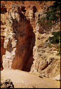
- Subject:
- National parks & reserves, Bryce Natural Bridge (Utah), Canyons, Bryce Canyon National Park (Utah), Cliffs, Bryce Canyon (Utah : Valley), Trees, Trails &...
- Series:
- 12-40
- Creator:
- Cushman, Charles W., 1896-1972
- Date Created:
- 1940-07-01
- Genre:
- Landscape photographs
- Frame Number:
- 2
- County:
- Garfield
- Abstract:
- View from Top of rocks near Natural Bridge
- Call Number:
- P01981
- Country:
- United States
- State/Province:
- Utah
- Physical Description:
- Image was originally mounted in a glass enclosure. Before digitization, the image was removed and placed in a Wess Plastic, Inc. brand, 2" x 2", pl...
- Alternate Identifier:
- 1240.2
- Persistent URL:
- http://purl.dlib.indiana.edu/iudl/archives/cushman/P01981
- Holding Location:
- Bloomington - University Archives
Wells Library E460
1320 E 10th St.
Bloomington, IN 47405
Contact at archives@indiana.edu, 812-855-1127
-
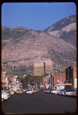
- Description:
- 100 f 6.3 tl
- Subject:
- Hotels, Union Station (Ogden, Utah), Streets, Automobiles, Street lights, Mountains, and Buildings
- Series:
- 16-58
- Creator:
- Cushman, Charles W., 1896-1972
- Date Created:
- 1958-08-24
- Genre:
- Landscape photographs and Cityscape photographs
- Frame Number:
- 23
- Street Address:
- Twenty-fifth Street
- County:
- Weber
- Abstract:
- East on 25th from Union Station
- Call Number:
- P10149
- City:
- Ogden
- Country:
- United States
- State/Province:
- Utah
- Alternate Identifier:
- 1658.23
- Persistent URL:
- http://purl.dlib.indiana.edu/iudl/archives/cushman/P10149
- Holding Location:
- Bloomington - University Archives
Wells Library E460
1320 E 10th St.
Bloomington, IN 47405
Contact at archives@indiana.edu, 812-855-1127
-
- Description:
- 100 f 6.3 tl
- Subject:
- Western Union Telegraph Company, Churches, Streets, Mountains, Trees, Coca-Cola Company, Signs (Notices), Advertisements, Ogden First Federal Insured Savings...
- Series:
- 16-58
- Creator:
- Cushman, Charles W., 1896-1972
- Date Created:
- 1958-08-24
- Genre:
- Cityscape photographs
- Frame Number:
- 22
- Street Address:
- Twenty-fourth Street
- County:
- Weber
- Abstract:
- View east on 24th St.
- Call Number:
- P10148
- City:
- Ogden
- Country:
- United States
- State/Province:
- Utah
- Alternate Identifier:
- 1658.22
- Persistent URL:
- http://purl.dlib.indiana.edu/iudl/archives/cushman/P10148
- Holding Location:
- Bloomington - University Archives
Wells Library E460
1320 E 10th St.
Bloomington, IN 47405
Contact at archives@indiana.edu, 812-855-1127
-
- Description:
- 100 f 6.3 tl
- Subject:
- Union Station (Ogden, Utah), Street lights, Mountains, Buildings, and Ogden, Mount (Utah)
- Series:
- 16-58
- Creator:
- Cushman, Charles W., 1896-1972
- Date Created:
- 1958-08-24
- Genre:
- Landscape photographs
- Frame Number:
- 25
- County:
- Weber
- Abstract:
- Ogden Pk. From Union Station
- Call Number:
- P10151
- City:
- Ogden
- Country:
- United States
- State/Province:
- Utah
- Alternate Identifier:
- 1658.25
- Persistent URL:
- http://purl.dlib.indiana.edu/iudl/archives/cushman/P10151
- Holding Location:
- Bloomington - University Archives
Wells Library E460
1320 E 10th St.
Bloomington, IN 47405
Contact at archives@indiana.edu, 812-855-1127
-
- Description:
- 100 f 6.3 sl
- Subject:
- Canyons, Cliffs, Trees, Swing bridge, Grotto Campground (Utah), Mountains, Shrubs, Zion National Park (Utah), Rivers, National parks & reserves, and Rock...
- Series:
- 7-58
- Creator:
- Cushman, Charles W., 1896-1972
- Date Created:
- 1958-04-28
- Genre:
- Landscape photographs
- Frame Number:
- 17
- County:
- Washington
- Abstract:
- View downstream from Swing Bridge at Grotto Campground
- Call Number:
- P09870
- Country:
- United States
- State/Province:
- Utah
- Alternate Identifier:
- 758.17
- Persistent URL:
- http://purl.dlib.indiana.edu/iudl/archives/cushman/P09870
- Holding Location:
- Bloomington - University Archives
Wells Library E460
1320 E 10th St.
Bloomington, IN 47405
Contact at archives@indiana.edu, 812-855-1127
-
- Description:
- 100 f 6.3 tl
- Subject:
- Canyons, Cliffs, Snow Canyon (Washington County, Utah), Rocks, Plants, and Rock formations
- Series:
- 8-58
- Creator:
- Cushman, Charles W., 1896-1972
- Date Created:
- 1958-04-29
- Genre:
- Landscape photographs
- Frame Number:
- 11
- County:
- Washington
- Abstract:
- View across Snow's Canyon, to left
- Call Number:
- P09899
- City:
- Saint George
- Country:
- United States
- State/Province:
- Utah
- Alternate Identifier:
- 858.11
- Persistent URL:
- http://purl.dlib.indiana.edu/iudl/archives/cushman/P09899
- Holding Location:
- Bloomington - University Archives
Wells Library E460
1320 E 10th St.
Bloomington, IN 47405
Contact at archives@indiana.edu, 812-855-1127
-
- Description:
- 100 f 5.6 sl
- Subject:
- Canyons, Mountains, Snow Canyon (Washington County, Utah), Plants, and Rock formations
- Series:
- 8-58
- Creator:
- Cushman, Charles W., 1896-1972
- Date Created:
- 1958-04-29
- Genre:
- Landscape photographs
- Frame Number:
- 10
- Street Address:
- Utah State Highway 18
- County:
- Washington
- Abstract:
- View across Snow's Canyon, to left
- Call Number:
- P09898
- City:
- Saint George
- Country:
- United States
- State/Province:
- Utah
- Alternate Identifier:
- 858.10
- Persistent URL:
- http://purl.dlib.indiana.edu/iudl/archives/cushman/P09898
- Holding Location:
- Bloomington - University Archives
Wells Library E460
1320 E 10th St.
Bloomington, IN 47405
Contact at archives@indiana.edu, 812-855-1127
-
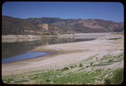
- Description:
- 100 f 8 tl
- Subject:
- Mountains, Dams, Reservoirs, Echo Reservoir (Utah), Weber River (Utah), Reflections, and Sand
- Series:
- 16-58
- Creator:
- Cushman, Charles W., 1896-1972
- Date Created:
- 1958-08-25
- Genre:
- Landscape photographs
- Frame Number:
- 28
- County:
- Summit
- Abstract:
- NW above Echo Res.
- Call Number:
- P10154
- Country:
- United States
- State/Province:
- Utah
- Alternate Identifier:
- 1658.28
- Persistent URL:
- http://purl.dlib.indiana.edu/iudl/archives/cushman/P10154
- Holding Location:
- Bloomington - University Archives
Wells Library E460
1320 E 10th St.
Bloomington, IN 47405
Contact at archives@indiana.edu, 812-855-1127
-
- Description:
- 100 f 6.3 tl
- Subject:
- Snow, Canyons, Mountains, Rock formations, Hills, Plants, Valleys, and Snow Canyon (Washington County, Utah)
- Series:
- 8-58
- Creator:
- Cushman, Charles W., 1896-1972
- Date Created:
- 1958-04-29
- Genre:
- Landscape photographs
- Frame Number:
- 9
- Street Address:
- Utah State Highway 18
- County:
- Washington
- Abstract:
- View across Snow's Canyon
- Call Number:
- P09897
- City:
- Saint George
- Country:
- United States
- State/Province:
- Utah
- Alternate Identifier:
- 858.9
- Persistent URL:
- http://purl.dlib.indiana.edu/iudl/archives/cushman/P09897
- Holding Location:
- Bloomington - University Archives
Wells Library E460
1320 E 10th St.
Bloomington, IN 47405
Contact at archives@indiana.edu, 812-855-1127
-
- Description:
- 100 f 8 sl
- Subject:
- Hills, Grasses, Reservoirs, Echo Reservoir (Utah), Weber River (Utah), Rivers, and Sand
- Series:
- 16-58
- Creator:
- Cushman, Charles W., 1896-1972
- Date Created:
- 1958-08-25
- Genre:
- Landscape photographs
- Frame Number:
- 26
- County:
- Summit
- Abstract:
- NW across Echo Reservoir of Weber river
- Call Number:
- P10152
- Country:
- United States
- State/Province:
- Utah
- Alternate Identifier:
- 1658.26
- Persistent URL:
- http://purl.dlib.indiana.edu/iudl/archives/cushman/P10152
- Holding Location:
- Bloomington - University Archives
Wells Library E460
1320 E 10th St.
Bloomington, IN 47405
Contact at archives@indiana.edu, 812-855-1127
-
- Description:
- 100 f 8 tl
- Subject:
- Rocks, Dirt, Mountains, National parks & reserves, Zion National Park (Utah), Clouds, Hills, and Plants
- Series:
- 7-58
- Creator:
- Cushman, Charles W., 1896-1972
- Date Created:
- 1958-04-28
- Genre:
- Landscape photographs
- Frame Number:
- 34
- County:
- Washington
- Abstract:
- Ridge to right
- Call Number:
- P09886
- Country:
- United States
- State/Province:
- Utah
- Alternate Identifier:
- 758.34
- Persistent URL:
- http://purl.dlib.indiana.edu/iudl/archives/cushman/P09886
- Holding Location:
- Bloomington - University Archives
Wells Library E460
1320 E 10th St.
Bloomington, IN 47405
Contact at archives@indiana.edu, 812-855-1127
-

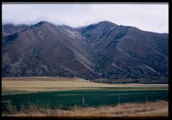
- Description:
- 50 f 5.6
- Subject:
- Wasatch Range (Utah and Idaho), Grasses, Trees, Plains, Mountains, and Fences
- Series:
- 9-53
- Creator:
- Cushman, Charles W., 1896-1972
- Date Created:
- 1953-10-11
- Genre:
- Landscape photographs
- Frame Number:
- 10
- Street Address:
- United States Highway 50
- County:
- Salt Lake
- Abstract:
- One of Wasatch mtns from US 50 south of Murray. dull[?] overcast.
- Call Number:
- P06811
- City:
- Murray
- Country:
- United States
- State/Province:
- Utah
- Alternate Identifier:
- 953.10
- Persistent URL:
- http://purl.dlib.indiana.edu/iudl/archives/cushman/P06811
- Holding Location:
- Bloomington - University Archives
Wells Library E460
1320 E 10th St.
Bloomington, IN 47405
Contact at archives@indiana.edu, 812-855-1127
-
- Description:
- 50 f 9
- Subject:
- Passes (Landforms), Mountains, Shrubs, Trees, Clouds, Fences, and Grasses
- Series:
- 9-53
- Creator:
- Cushman, Charles W., 1896-1972
- Date Created:
- 1953-10-11
- Genre:
- Landscape photographs
- Frame Number:
- 19
- Street Address:
- United States Highway 50
- County:
- Utah
- Abstract:
- West through same mtn. pass.
- Call Number:
- P06820
- City:
- Thistle
- Country:
- United States
- State/Province:
- Utah
- Alternate Identifier:
- 953.19
- Persistent URL:
- http://purl.dlib.indiana.edu/iudl/archives/cushman/P06820
- Holding Location:
- Bloomington - University Archives
Wells Library E460
1320 E 10th St.
Bloomington, IN 47405
Contact at archives@indiana.edu, 812-855-1127
-
- Description:
- 50 f 8
- Subject:
- Grasses, Dirt roads, Trees, Mountains, Shrubs, Railroad tracks, Passes (Landforms), Utility poles, Railroads, and Gates
- Series:
- 9-53
- Creator:
- Cushman, Charles W., 1896-1972
- Date Created:
- 1953-10-11
- Genre:
- Views
- Frame Number:
- 16
- Street Address:
- United States Highway 50
- County:
- Utah
- Abstract:
- Mtn pass 5 mi w. of Thistle.
- Call Number:
- P06817
- City:
- Thistle
- Country:
- United States
- State/Province:
- Utah
- Alternate Identifier:
- 953.16
- Persistent URL:
- http://purl.dlib.indiana.edu/iudl/archives/cushman/P06817
- Holding Location:
- Bloomington - University Archives
Wells Library E460
1320 E 10th St.
Bloomington, IN 47405
Contact at archives@indiana.edu, 812-855-1127
-
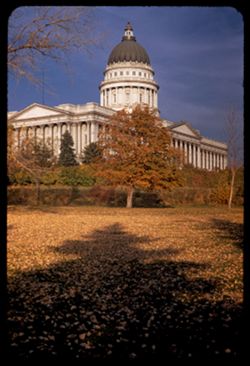
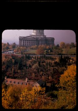
- Description:
- 25 f 9
- Subject:
- Capitol Hill (Salt Lake City, Utah), Colonnades, Shadows, Tree limbs, Lawns, Shrubs, Utah Capitol, Pediments, Domes, Columns, Leaves, Trees, Capitols, and Hills
- Series:
- 28-52
- Creator:
- Cushman, Charles W., 1896-1972
- Date Created:
- 1952-11-06
- Genre:
- Architectural photographs
- Frame Number:
- 6
- County:
- Salt Lake
- Abstract:
- Capitol from SW.
- Call Number:
- P06490
- City:
- Salt Lake City
- Country:
- United States
- State/Province:
- Utah
- Alternate Identifier:
- 2852.6
- Persistent URL:
- http://purl.dlib.indiana.edu/iudl/archives/cushman/P06490
- Holding Location:
- Bloomington - University Archives
Wells Library E460
1320 E 10th St.
Bloomington, IN 47405
Contact at archives@indiana.edu, 812-855-1127
-
- Description:
- 50 f 5.6 Pola
- Subject:
- Grasses, Trees, Mountains, Fences, Shrubs, Clouds, and Hills
- Series:
- 9-53
- Creator:
- Cushman, Charles W., 1896-1972
- Date Created:
- 1953-10-11
- Genre:
- Landscape photographs
- Frame Number:
- 14
- Street Address:
- United States Highway 50
- County:
- Utah
- Abstract:
- From US 50 6 mi w of Thistle.
- Call Number:
- P06815
- City:
- Thistle
- Country:
- United States
- State/Province:
- Utah
- Alternate Identifier:
- 953.14
- Persistent URL:
- http://purl.dlib.indiana.edu/iudl/archives/cushman/P06815
- Holding Location:
- Bloomington - University Archives
Wells Library E460
1320 E 10th St.
Bloomington, IN 47405
Contact at archives@indiana.edu, 812-855-1127
-

- Description:
- 25 f 9
- Subject:
- Capitol Hill (Salt Lake City, Utah), Trees, Lawns, Shrubs, Utah Capitol, Windows, Pediments, Domes, Columns, Leaves, Colonnades, and Capitols
- Series:
- 28-52
- Creator:
- Cushman, Charles W., 1896-1972
- Date Created:
- 1952-11-06
- Genre:
- Architectural photographs
- Frame Number:
- 5
- County:
- Salt Lake
- Abstract:
- Capitol from SW.
- Call Number:
- P06489
- City:
- Salt Lake City
- Country:
- United States
- State/Province:
- Utah
- Physical Description:
- masked.
- Alternate Identifier:
- 2852.5
- Persistent URL:
- http://purl.dlib.indiana.edu/iudl/archives/cushman/P06489
- Holding Location:
- Bloomington - University Archives
Wells Library E460
1320 E 10th St.
Bloomington, IN 47405
Contact at archives@indiana.edu, 812-855-1127
-
- Description:
- 25 f 4.8 Pola
- Subject:
- City Creek (Salt Lake County, Utah), Automobiles, Trees, Streets, Tree limbs, Cities & towns, Capitols, Utah Capitol, Hills, Columns, Capitol Hill (Salt ...
- Series:
- 27-52
- Creator:
- Cushman, Charles W., 1896-1972
- Date Created:
- 1952-11-06
- Genre:
- Views
- Frame Number:
- 39
- County:
- Salt Lake
- Abstract:
- Utah Capitol across City Creek.
- Call Number:
- P06484
- City:
- Salt Lake City
- Country:
- United States
- State/Province:
- Utah
- Physical Description:
- masked.
- Alternate Identifier:
- 2752.39
- Persistent URL:
- http://purl.dlib.indiana.edu/iudl/archives/cushman/P06484
- Holding Location:
- Bloomington - University Archives
Wells Library E460
1320 E 10th St.
Bloomington, IN 47405
Contact at archives@indiana.edu, 812-855-1127
-
- Description:
- 50 f 5.3 Pola
- Subject:
- Croplands, Light, Haystacks, Mountains, Dirt roads, Agricultural facilities, Carts & wagons, Wasatch Range (Utah and Idaho), Wood poles, Grasses, Fire hy...
- Series:
- 9-53
- Creator:
- Cushman, Charles W., 1896-1972
- Date Created:
- 1953-10-11
- Genre:
- Landscape photographs
- Frame Number:
- 12
- Street Address:
- United States Highway 50
- County:
- Utah
- Abstract:
- Mountain in new sun light. From US 50 so. of Mapleton.
- Call Number:
- P06813
- City:
- Mapleton
- Country:
- United States
- State/Province:
- Utah
- Alternate Identifier:
- 953.12
- Persistent URL:
- http://purl.dlib.indiana.edu/iudl/archives/cushman/P06813
- Holding Location:
- Bloomington - University Archives
Wells Library E460
1320 E 10th St.
Bloomington, IN 47405
Contact at archives@indiana.edu, 812-855-1127
-
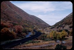
- Description:
- 50 f 9
- Subject:
- Rocks, Grasses, Roads, Trees, Mountains, Fences, Shrubs, Clouds, and Passes (Landforms)
- Series:
- 9-53
- Creator:
- Cushman, Charles W., 1896-1972
- Date Created:
- 1953-10-11
- Genre:
- Landscape photographs
- Frame Number:
- 20
- Street Address:
- United States Highway 50
- County:
- Utah
- Abstract:
- West through same mtn. pass.
- Call Number:
- P06821
- City:
- Thistle
- Country:
- United States
- State/Province:
- Utah
- Alternate Identifier:
- 953.20
- Persistent URL:
- http://purl.dlib.indiana.edu/iudl/archives/cushman/P06821
- Holding Location:
- Bloomington - University Archives
Wells Library E460
1320 E 10th St.
Bloomington, IN 47405
Contact at archives@indiana.edu, 812-855-1127
-
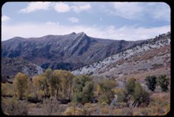
- Description:
- 50 f 8
- Subject:
- Grasses, Trees, Mountains, Shrubs, Clouds, and Hills
- Series:
- 9-53
- Creator:
- Cushman, Charles W., 1896-1972
- Date Created:
- 1953-10-11
- Genre:
- Landscape photographs
- Frame Number:
- 21
- County:
- Utah
- Abstract:
- Looking back from 1 mile east of Thistle.
- Call Number:
- P06822
- City:
- Thistle
- Country:
- United States
- State/Province:
- Utah
- Alternate Identifier:
- 953.21
- Persistent URL:
- http://purl.dlib.indiana.edu/iudl/archives/cushman/P06822
- Holding Location:
- Bloomington - University Archives
Wells Library E460
1320 E 10th St.
Bloomington, IN 47405
Contact at archives@indiana.edu, 812-855-1127
-
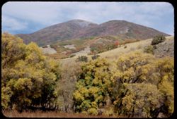
- Description:
- 50 f 9
- Subject:
- Hills, Mountains, Trees, and Grasses
- Series:
- 9-53
- Creator:
- Cushman, Charles W., 1896-1972
- Date Created:
- 1953-10-11
- Genre:
- Landscape photographs
- Frame Number:
- 17
- Street Address:
- United States Highway 50
- County:
- Utah
- Abstract:
- Up at mtn 4 mi w of Thistle.
- Call Number:
- P06818
- City:
- Thistle
- Country:
- United States
- State/Province:
- Utah
- Alternate Identifier:
- 953.17
- Persistent URL:
- http://purl.dlib.indiana.edu/iudl/archives/cushman/P06818
- Holding Location:
- Bloomington - University Archives
Wells Library E460
1320 E 10th St.
Bloomington, IN 47405
Contact at archives@indiana.edu, 812-855-1127
-

- Description:
- 100 f 5.6 tl
- Subject:
- Railroad stations, Buses, Trees, Streets, Street lights, Union Pacific Railroad Company, Automobiles, and Parking lots
- Series:
- 16-58
- Creator:
- Cushman, Charles W., 1896-1972
- Date Created:
- 1958-08-24
- Genre:
- Architectural photographs
- Frame Number:
- 17
- County:
- Salt Lake
- Abstract:
- UP depot
- Call Number:
- P10143
- City:
- Salt Lake City
- Country:
- United States
- State/Province:
- Utah
- Physical Description:
- masked.
- Alternate Identifier:
- 1658.17
- Persistent URL:
- http://purl.dlib.indiana.edu/iudl/archives/cushman/P10143
- Holding Location:
- Bloomington - University Archives
Wells Library E460
1320 E 10th St.
Bloomington, IN 47405
Contact at archives@indiana.edu, 812-855-1127
-
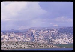
- Description:
- 100 f 14 tl
- Subject:
- Bodies of water, Coastlines, Mountains, Rock formations, Clouds, Hills, and Uinta Mountains (Utah and Wyo.)
- Series:
- 10-66
- Creator:
- Cushman, Charles W., 1896-1972
- Date Created:
- 1966-06-18
- Genre:
- Landscape photographs
- Frame Number:
- 6
- County:
- Uintah
- Abstract:
- Mtns north of Vernal
- Call Number:
- P15446
- City:
- Vernal
- Country:
- United States
- State/Province:
- Utah
- Alternate Identifier:
- 1066.6
- Persistent URL:
- http://purl.dlib.indiana.edu/iudl/archives/cushman/P15446
- Holding Location:
- Bloomington - University Archives
Wells Library E460
1320 E 10th St.
Bloomington, IN 47405
Contact at archives@indiana.edu, 812-855-1127
-
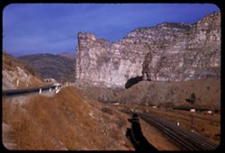
- Description:
- 25 f 9
- Subject:
- Canyons, Roads, Mountains, Denver and Rio Grande Western Railway Company, Rock formations, Railroad tracks, Railroad cars, Coal, Cliffs, Buildings, Price Riv...
- Series:
- 27-52
- Creator:
- Cushman, Charles W., 1896-1972
- Date Created:
- 1952-11-05
- Genre:
- Landscape photographs
- Frame Number:
- 31
- Street Address:
- United States Highway 50
- County:
- Carbon
- Abstract:
- Hwy 50 runs through Price river gorge along with D + RGW at Royal, north of Helper.
- Call Number:
- P06476
- City:
- Royal and Helper
- Country:
- United States
- State/Province:
- Utah
- Alternate Identifier:
- 2752.31
- Persistent URL:
- http://purl.dlib.indiana.edu/iudl/archives/cushman/P06476
- Holding Location:
- Bloomington - University Archives
Wells Library E460
1320 E 10th St.
Bloomington, IN 47405
Contact at archives@indiana.edu, 812-855-1127
-
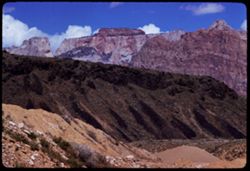
- Description:
- 100 f 8 tl
- Subject:
- Dirt, Mountains, National parks & reserves, Zion National Park (Utah), Clouds, Hills, West Temple (Utah), and Plants
- Series:
- 7-58
- Creator:
- Cushman, Charles W., 1896-1972
- Date Created:
- 1958-04-28
- Genre:
- Landscape photographs
- Frame Number:
- 33
- County:
- Washington
- Abstract:
- West Temple of Zion from SW.
- Call Number:
- P09885
- Country:
- United States
- State/Province:
- Utah
- Alternate Identifier:
- 758.33
- Persistent URL:
- http://purl.dlib.indiana.edu/iudl/archives/cushman/P09885
- Holding Location:
- Bloomington - University Archives
Wells Library E460
1320 E 10th St.
Bloomington, IN 47405
Contact at archives@indiana.edu, 812-855-1127
-
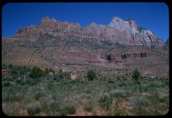
- Description:
- 100 f 6.3 sl
- Subject:
- Cliffs, Mountains, Rock formations, Zion National Park (Utah), West Temple (Utah), Plants, and National parks & reserves
- Series:
- 4-58
- Creator:
- Cushman, Charles W., 1896-1972
- Date Created:
- 1958-04-26
- Genre:
- Landscape photographs
- Frame Number:
- 10
- County:
- Washington
- Abstract:
- West Temple
- Call Number:
- P09762
- Country:
- United States
- State/Province:
- Utah
- Alternate Identifier:
- 458.10
- Persistent URL:
- http://purl.dlib.indiana.edu/iudl/archives/cushman/P09762
- Holding Location:
- Bloomington - University Archives
Wells Library E460
1320 E 10th St.
Bloomington, IN 47405
Contact at archives@indiana.edu, 812-855-1127
-
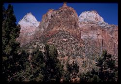
- Description:
- 100 f 6.3 sl
- Subject:
- Canyons, Cliffs, Trees, Pines, National parks & reserves, Zion National Park (Utah), and Rock formations
- Series:
- 5-58
- Creator:
- Cushman, Charles W., 1896-1972
- Date Created:
- 1958-04-26
- Genre:
- Landscape photographs
- Frame Number:
- 1
- County:
- Washington
- Abstract:
- [G] View up & NE from Park Hdqtrs
- Call Number:
- P09791
- Country:
- United States
- State/Province:
- Utah
- Physical Description:
- Image was originally mounted in a glass enclosure. Before digitization, the image was removed and placed in a Wess Plastic, Inc. brand, 2" x 2", pl...
- Alternate Identifier:
- 558.1
- Persistent URL:
- http://purl.dlib.indiana.edu/iudl/archives/cushman/P09791
- Holding Location:
- Bloomington - University Archives
Wells Library E460
1320 E 10th St.
Bloomington, IN 47405
Contact at archives@indiana.edu, 812-855-1127
-
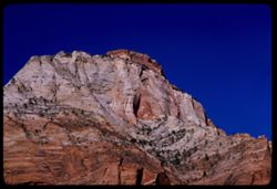
- Description:
- 100 f 8 tl
- Subject:
- Rock formations, Mountains, Plants, East Temple (Utah), Zion National Park (Utah), and National parks & reserves
- Series:
- 5-58
- Creator:
- Cushman, Charles W., 1896-1972
- Date Created:
- 1958-04-26
- Genre:
- Landscape photographs
- Frame Number:
- 21
- County:
- Washington
- Abstract:
- Penthouse on East Temple
- Call Number:
- P09808
- Country:
- United States
- State/Province:
- Utah
- Alternate Identifier:
- 558.21
- Persistent URL:
- http://purl.dlib.indiana.edu/iudl/archives/cushman/P09808
- Holding Location:
- Bloomington - University Archives
Wells Library E460
1320 E 10th St.
Bloomington, IN 47405
Contact at archives@indiana.edu, 812-855-1127
-
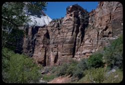
- Description:
- 50 f 8 sl
- Subject:
- National parks & reserves, Zion National Park (Utah), Weeping Rock (Utah), Cliffs, and Trees
- Series:
- 4-58
- Creator:
- Cushman, Charles W., 1896-1972
- Date Created:
- 1958-04-26
- Genre:
- Landscape photographs
- Frame Number:
- 22
- County:
- Washington
- Abstract:
- From same point - to nw
- Call Number:
- P09774
- Country:
- United States
- State/Province:
- Utah
- Alternate Identifier:
- 458.22
- Persistent URL:
- http://purl.dlib.indiana.edu/iudl/archives/cushman/P09774
- Holding Location:
- Bloomington - University Archives
Wells Library E460
1320 E 10th St.
Bloomington, IN 47405
Contact at archives@indiana.edu, 812-855-1127
-
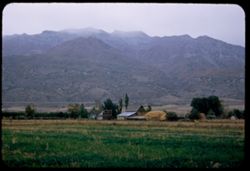
- Description:
- 50 f 4.5
- Subject:
- Wasatch Range (Utah and Idaho), Barns, Grasses, Trees, Plains, Mountains, Fences, Hay, Timpanogos, Mount (Utah), Haystacks, and Farmhouses
- Series:
- 9-53
- Creator:
- Cushman, Charles W., 1896-1972
- Date Created:
- 1953-10-11
- Genre:
- Landscape photographs
- Frame Number:
- 11
- County:
- Utah
- Abstract:
- Timpanogos from Orem.
- Call Number:
- P06812
- City:
- Orem
- Country:
- United States
- State/Province:
- Utah
- Alternate Identifier:
- 953.11
- Persistent URL:
- http://purl.dlib.indiana.edu/iudl/archives/cushman/P06812
- Holding Location:
- Bloomington - University Archives
Wells Library E460
1320 E 10th St.
Bloomington, IN 47405
Contact at archives@indiana.edu, 812-855-1127
-
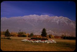
- Description:
- 25 f 6.3 Pola
- Subject:
- Trees, Flowers, Mountains, Lawns, Shrubs, Timpanogos, Mount (Utah), and Utility poles
- Series:
- 27-52
- Creator:
- Cushman, Charles W., 1896-1972
- Date Created:
- 1952-11-05
- Genre:
- Landscape photographs
- Frame Number:
- 38
- County:
- Utah
- Abstract:
- Great rock mtn north of Provo. 11,957 ft.
- Call Number:
- P06483
- City:
- Provo
- Country:
- United States
- State/Province:
- Utah
- Alternate Identifier:
- 2752.38
- Persistent URL:
- http://purl.dlib.indiana.edu/iudl/archives/cushman/P06483
- Holding Location:
- Bloomington - University Archives
Wells Library E460
1320 E 10th St.
Bloomington, IN 47405
Contact at archives@indiana.edu, 812-855-1127
-
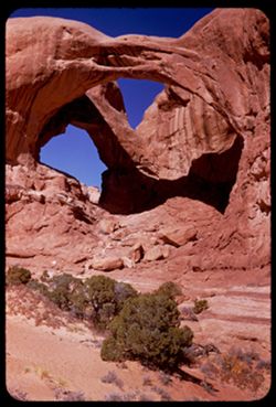
- Description:
- 50 f 8
- Subject:
- Rocks, Cliffs, Trees, Boulders, Shadows, Rock formations, Arches National Park (Utah), Double Arch (Utah), National parks & reserves, and Shrubs
- Series:
- 27-52
- Creator:
- Cushman, Charles W., 1896-1972
- Date Created:
- 1952-11-04
- Genre:
- Landscape photographs
- Frame Number:
- 10
- County:
- Grand
- Abstract:
- Double Arch.
- Call Number:
- P06455
- City:
- Moab
- Country:
- United States
- State/Province:
- Utah
- Alternate Identifier:
- 2752.10
- Persistent URL:
- http://purl.dlib.indiana.edu/iudl/archives/cushman/P06455
- Holding Location:
- Bloomington - University Archives
Wells Library E460
1320 E 10th St.
Bloomington, IN 47405
Contact at archives@indiana.edu, 812-855-1127
-
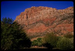
- Description:
- 100 f 6.3 sl
- Subject:
- Rocks, Trees, Driftwood Lodge (Springdale, Utah), National parks & reserves, Zion National Park (Utah), Watchman (Utah), and Rock formations
- Series:
- 5-58
- Creator:
- Cushman, Charles W., 1896-1972
- Date Created:
- 1958-04-26
- Genre:
- Landscape photographs
- Frame Number:
- 27
- County:
- Washington
- Abstract:
- from balcony of Driftwood Lodge - The Watchman
- Call Number:
- P09813
- City:
- Springdale
- Country:
- United States
- State/Province:
- Utah
- Alternate Identifier:
- 558.27
- Persistent URL:
- http://purl.dlib.indiana.edu/iudl/archives/cushman/P09813
- Holding Location:
- Bloomington - University Archives
Wells Library E460
1320 E 10th St.
Bloomington, IN 47405
Contact at archives@indiana.edu, 812-855-1127
-
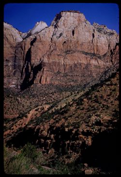
- Description:
- 100 f 8 sl
- Subject:
- Rocks, Canyons, Cliffs, Sentinel (Washington County, Utah), Rock formations, Zion National Park (Utah), Zion Canyon (Utah), Plants, and National parks & ...
- Series:
- 5-58
- Creator:
- Cushman, Charles W., 1896-1972
- Date Created:
- 1958-04-27
- Genre:
- Landscape photographs
- Frame Number:
- 29
- County:
- Washington
- Abstract:
- The Sentinel [L]
- Call Number:
- P09815
- Country:
- United States
- State/Province:
- Utah
- Alternate Identifier:
- 558.29
- Persistent URL:
- http://purl.dlib.indiana.edu/iudl/archives/cushman/P09815
- Holding Location:
- Bloomington - University Archives
Wells Library E460
1320 E 10th St.
Bloomington, IN 47405
Contact at archives@indiana.edu, 812-855-1127
-
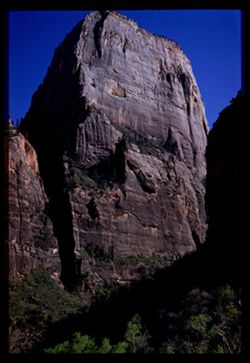
- Description:
- 50 f 9 sl
- Subject:
- National parks & reserves, Zion National Park (Utah), Cliffs, Great White Throne (Utah), Trees, Shadows, and Rock formations
- Series:
- 5-58
- Creator:
- Cushman, Charles W., 1896-1972
- Date Created:
- 1958-04-26
- Genre:
- Landscape photographs
- Frame Number:
- 13
- County:
- Washington
- Abstract:
- [G] G W Throne
- Call Number:
- P09801
- Country:
- United States
- State/Province:
- Utah
- Physical Description:
- Image was originally mounted in a glass enclosure. Before digitization, the image was removed and placed in a Wess Plastic, Inc. brand, 2" x 2", pl...
- Alternate Identifier:
- 558.13
- Persistent URL:
- http://purl.dlib.indiana.edu/iudl/archives/cushman/P09801
- Holding Location:
- Bloomington - University Archives
Wells Library E460
1320 E 10th St.
Bloomington, IN 47405
Contact at archives@indiana.edu, 812-855-1127
-
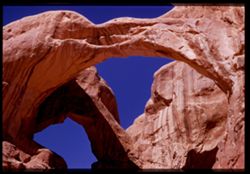
- Description:
- 50 f 6
- Subject:
- Cliffs, Shadows, National parks & reserves, Arches National Park (Utah), Double Arch (Utah), and Rock formations
- Series:
- 27-52
- Creator:
- Cushman, Charles W., 1896-1972
- Date Created:
- 1952-11-04
- Genre:
- Snapshots
- Frame Number:
- 18
- County:
- Grand
- Abstract:
- Up into Double Arch.
- Call Number:
- P06463
- Country:
- United States
- State/Province:
- Utah
- Physical Description:
- Image was originally mounted in a glass enclosure. Before digitization, the image was removed and placed in a Wess Plastic, Inc. brand, 2" x 2", pl...
- Alternate Identifier:
- 2752.18
- Persistent URL:
- http://purl.dlib.indiana.edu/iudl/archives/cushman/P06463
- Holding Location:
- Bloomington - University Archives
Wells Library E460
1320 E 10th St.
Bloomington, IN 47405
Contact at archives@indiana.edu, 812-855-1127
-
- Description:
- 100 f 16 TL
- Subject:
- Boundaries, Dogs, Posing, Four Corners Region, Automobiles, Children, Families, Rocks, Sightseers, Railings, Plaques, Sites, and Mesas
- Series:
- 36-65
- Creator:
- Cushman, Charles W., 1896-1972
- Date Created:
- 1965-10-07
- Genre:
- Portraits, Snapshots, and Ethnographic photographs
- Frame Number:
- 11
- Abstract:
- At 4 Corners.
- Call Number:
- P15079
- Country:
- United States
- State/Province:
- New Mexico, Colorado, Arizona, and Utah
- Alternate Identifier:
- 3665.11
- Persistent URL:
- http://purl.dlib.indiana.edu/iudl/archives/cushman/P15079
- Holding Location:
- Bloomington - University Archives
Wells Library E460
1320 E 10th St.
Bloomington, IN 47405
Contact at archives@indiana.edu, 812-855-1127
- « Previous
- Next »
- 1
- 2
- 3
- 4