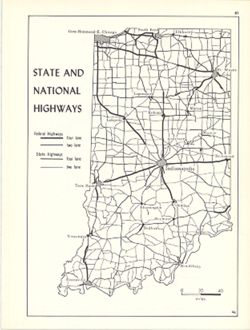
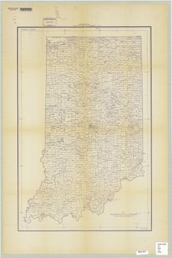
Shows two lane and four lane federal highways and two lane and four lane state highways. Detached from: An atlas of Indiana / by Robert C. Kingsbury , wit...
Call Number:
G4091.P2 1970 .K56
Caption:
Imprint: Bloomington, Indiana : Department of Geography, Indiana University, [1970]
Physical Description:
Scale: Approximately 1:2,000,000 and Dimensions: 26 x 18 cm, on sheet 28 x 21 cm
Alternate Identifier:
Alternate ID: 317383IP and Title Control Number: a15938064
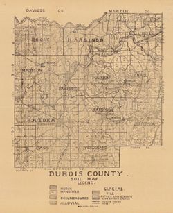
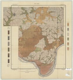
Shows school houses, public roads, and railroads. Detached from: A soil survey of four counties of southern Indiana / Chas. W. Shannon and L.C. Snider. In...
Call Number:
G4093.D8J3 1908 .I53
Caption:
Imprint: [Indianapolis] : [Indiana Department of Geology and Natural Resources], [1909]
Physical Description:
Scale: Approximately 1:126,720 and Dimensions: 39 x 33 cm
Alternate Identifier:
Title Control Number: a16091036 and Alternate ID: 390726IP
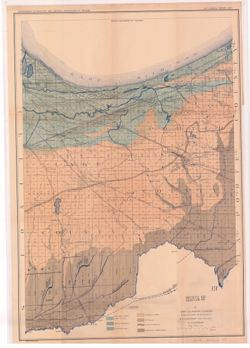
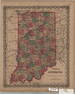
Shows lakes, beaches, sand-dune area, morainic area, till plains, crest of moraine, and Kankakee Marsh area. Detached from: The geology of Lake and Porter...
Call Number:
G4093.L3C5 1897 .A8
Caption:
Imprint: [Indianapolis] : Department of Geology and Natural Resources of Indiana, [1898] and Imprint: Indianapolis, Ind. : Wm. B. Burford, lith., [1898]
Physical Description:
Dimensions: 55 x 42 cm and Scale: Approximately 1:126,720. 2 miles = 1 inch
Alternate Identifier:
Title Control Number: a17035654 and Alternate ID: 390726IP
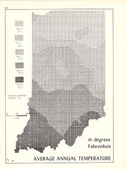
Computer generated isometric map obtained through use of the facilities of Indiana University's Research Computer Center. ASCII-art map created using SYM...
Call Number:
G4091.C82 1970 .K56
Caption:
Imprint: Bloomington, Indiana : Department of Geography, Indiana University, [1970]
Physical Description:
Dimensions: 26 x 18 cm and Scale: Approximately 1:1,950,000
Alternate Identifier:
Alternate ID: 317383IP and Title Control Number: a15995471
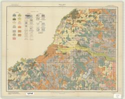
Topical Subject: Soils, Geographic Subject: Spencer County (Ind.), Geographic Subject: Warrick County (Ind.), Geographic Subject: Boonville (Ind.), and Topic...
Creator:
Mangum, A. W.
Publisher:
United States. Bureau of Soils
Date Created:
1904
Identifier:
VAC3073-M-00804
Genre:
Thematic maps
Geographic Location:
Coordinates: W0871000 W0870000 N0380500 N0374600
Related URL:
Catalog URL: https://iucat.iu.edu/catalog/2874208
Abstract:
Relief shown by contours. Map covers portions of Spencer and Warrick Counties in Indiana. Shows soil types classification by colors and symbols. "Field ...
Call Number:
G4093 .S5J3 1904 .M36
Caption:
Imprint: [Washington, D.C.?] : The Bureau, [1904?]

![Jackson County [Indiana] land use map [map] : preliminary](https://iiif.uits.iu.edu/iiif/2/b27750001%2Ffiles%2F79afb54a-ede0-4189-97ab-813c27a4f6d8/full/250,/0/default.jpg)