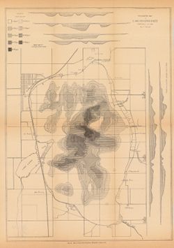
Depth shown by isolines, patterning, and profile. In addition to Lake Maxinkuckee, the map shows local sites including Marmont (now Culver), a railroad, mill...
Call Number:
G4092.M33 1900 .S36
Caption:
Imprint: [Indianapolis] : [Indiana. Department of Geology and Natural Resources], [1901]
Physical Description:
Scale: Approximately 1:14,630 and Dimensions: on sheet 44 x 33 cm
Alternate Identifier:
Title Control Number: a18279165 and Alternate ID: 390726IP