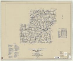
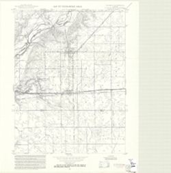
Topical Subject: Roads and Geographic Subject: Owen County (Ind.)
Creator:
Indiana. State Highway Commission (1919-1953)
Publisher:
State Highway Commission of Indiana
Date Created:
1949
Identifier:
VAC3073-M-00310
Genre:
Road maps
Geographic Location:
Coordinates: W0870300 W0863800 N0392800 N0391000
Related URL:
Catalog URL: https://iucat.iu.edu/catalog/5707900
Abstract:
Blueline. "State roads revised to January 1, 1949." "1937." "Data obtained from State-wide Highway Planning Survey." Includes l...
Call Number:
G4093.O8 P2 1949 .I53
Caption:
Imprint: [Indianapolis?] : State Highway Commission of Indiana, 1949.
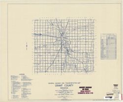
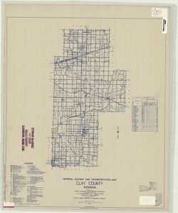
Geographic Subject: Grant County (Ind.) and Topical Subject: Roads
Creator:
Indiana. State Highway Commission (1919-1953)
Publisher:
State Highway Commission of Indiana
Date Created:
1949
Identifier:
VAC3073-M-00309
Genre:
Road maps
Geographic Location:
Coordinates: W0855200 W0852700 N0403900 N0402300
Related URL:
Catalog URL: https://iucat.iu.edu/catalog/5706036
Abstract:
Blueline. "State roads revised to January 1, 1949." "1937." "Data obtained from Statewide Highway Planning Survey." Includes lo...
Call Number:
G4093.G6P2 1949 .I53
Caption:
Imprint: [Indianapolis?] : State Highway Commission of Indiana, 1949.
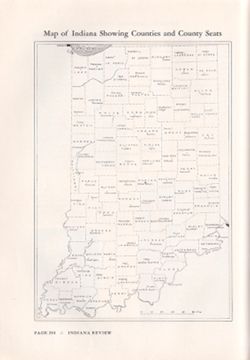
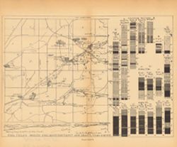
Appears in Indiana review, pictorial, political, historical, the story of the State of Indiana from its beginning and a general survey of progress to the pre...
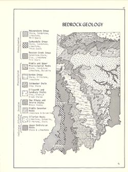
Includes geological time table. Detached from: An atlas of Indiana / by Robert C. Kingsbury , with contributions from John M. Hollingsworth and others. Bl...
Call Number:
G4091.C5 1970 .K57
Caption:
Imprint: Bloomington, Indiana : Department of Geography, Indiana University, [1970]
Physical Description:
Dimensions: 26 x 18 cm, on sheet 28 x 21 cm and Scale: Approximately 1:2,150,000
Alternate Identifier:
Title Control Number: a15939159 and Alternate ID: 317383IP
Geographic Subject: Henry County (Ind.), Geographic Subject: Rush County (Ind.), Topical Subject: Floods, Topical Subject: Floodplains, and Topical Subject: ...
Creator:
Geological Survey (U.S.)
Publisher:
Geological Survey (U.S.)
Date Created:
1970
Identifier:
VAC3073-M-00304
Genre:
Quadrangle maps, Topographic maps, and 7.5 minute topographic maps
Filing title: Dunreith, Ind. Relief shown by contours and spot heights. Contour interval 10 feet. Includes quadrangle location map. Flood prone areas and occ...
Relief shown by profile. Includes map showing locations of coal fields in Vigo County, Indiana, as well as 2 geological cross sections along the north and so...
Call Number:
G4093.V5H9 1898 .C63
Caption:
Imprint: [Indianapolis] : [Indiana Department of Geology and Natural Resources], [1899]
Physical Description:
Scale: Approximately 1:63,360. Vertical scale varies and Dimensions: 23 x 27 cm
Alternate Identifier:
Title Control Number: a18214647 and Alternate ID: 390726IP
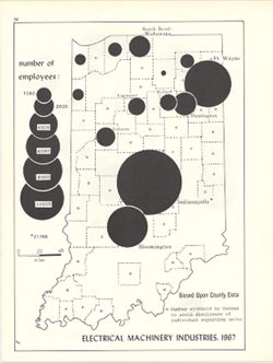
Graduated symbol map. Shows number of employees by county. Detached from: An atlas of Indiana / by Robert C. Kingsbury , with contributions from John M. H...
Call Number:
G4091.G8 1967 .K5
Caption:
Imprint: Bloomington, Indiana : Department of Geography, Indiana University, [1970]
Physical Description:
Dimensions: 26 x 18 cm, on sheet 28 x 21 cm and Scale: Approximately 1:1,950,000
Alternate Identifier:
Alternate ID: 317383IP and Title Control Number: a15951253

![[Bloomington, Indiana, cadastral map]](https://iiif.uits.iu.edu/iiif/2/0r9686792%2Ffiles%2F47529974-267a-4ca2-bcce-8ead7355fbf3/full/250,/0/default.jpg)
![Jefferson County [Indiana] preliminary land use map](https://iiif.uits.iu.edu/iiif/2/2f75sc94w%2Ffiles%2F7a98897d-f193-46e6-9bdf-a873b1f3fc06/full/250,/0/default.jpg)
