
Search Constraints
You searched for:
Campus
IUB
Remove constraint Campus: IUB
Subject
Deserts
Remove constraint Subject: Deserts
« Previous |
1 - 50 of 415
|
Next »
Search Results
-
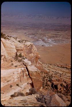
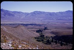
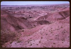
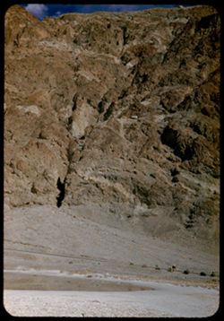
- Description:
- 25 f 8 Pola
- Subject:
- Colorado River Valley (Colo.-Mexico), National parks & reserves, Deserts, Valleys, Colorado National Monument (Colo.), Cliffs, Mountains, Shrubs, Buttes,...
- Series:
- 26-52
- Creator:
- Cushman, Charles W., 1896-1972
- Date Created:
- 1952-11-03
- Genre:
- Landscape photographs
- Frame Number:
- 6
- County:
- Mesa
- Abstract:
- View down [P] across buttes + valley of Colo. River.
- Call Number:
- P06413
- City:
- Grand Junction
- Country:
- United States
- State/Province:
- Colorado
- Alternate Identifier:
- 2652.6
- Persistent URL:
- http://purl.dlib.indiana.edu/iudl/archives/cushman/P06413
- Holding Location:
- Bloomington - University Archives
Wells Library E460
1320 E 10th St.
Bloomington, IN 47405
Contact at archives@indiana.edu, 812-855-1127
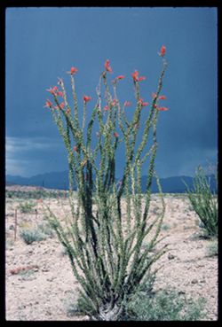
-
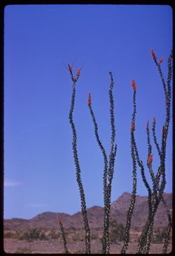
- Description:
- 100 f 8 tl
- Subject:
- Deserts, Flowers, Ocotillo, Mountains, Shrubs, and Clouds
- Series:
- 11-59
- Creator:
- Cushman, Charles W., 1896-1972
- Date Created:
- 1959-03-24
- Genre:
- Identification photographs
- Frame Number:
- 11
- County:
- Yuma and Riverside
- Abstract:
- Our finest ocotillo - 15-20 mi east of Blythe
- Call Number:
- P10736
- City:
- Blythe and Quartzsite
- Country:
- United States
- State/Province:
- Arizona and California
- Alternate Identifier:
- 1159.11
- Persistent URL:
- http://purl.dlib.indiana.edu/iudl/archives/cushman/P10736
- Holding Location:
- Bloomington - University Archives
Wells Library E460
1320 E 10th St.
Bloomington, IN 47405
Contact at archives@indiana.edu, 812-855-1127
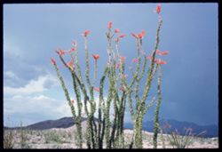
-
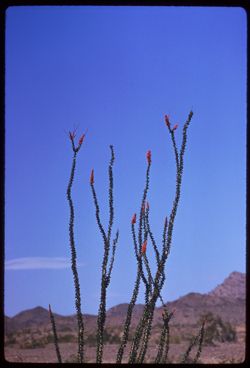
- Description:
- 250 f 5.6
- Subject:
- Deserts, Flowers, Ocotillo, Mountains, Shrubs, and Clouds
- Series:
- 11-59
- Creator:
- Cushman, Charles W., 1896-1972
- Date Created:
- 1959-03-24
- Genre:
- Identification photographs
- Frame Number:
- 12
- County:
- Yuma and Riverside
- Abstract:
- Our finest ocotillo - 15-20 mi east of Blythe
- Call Number:
- P10737
- City:
- Blythe and Quartzsite
- Country:
- United States
- State/Province:
- Arizona and California
- Alternate Identifier:
- 1159.12
- Persistent URL:
- http://purl.dlib.indiana.edu/iudl/archives/cushman/P10737
- Holding Location:
- Bloomington - University Archives
Wells Library E460
1320 E 10th St.
Bloomington, IN 47405
Contact at archives@indiana.edu, 812-855-1127
-
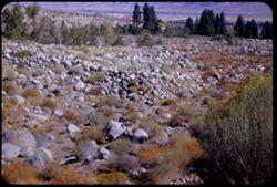
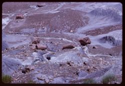
- Description:
- 50 f 9
- Subject:
- Deserts, Glacier Lodge (Calif.), Shrubs, Trees, and Rocks
- Series:
- 12-54
- Creator:
- Cushman, Charles W., 1896-1972
- Date Created:
- 1954-09-18
- Genre:
- Landscape photographs
- Frame Number:
- 14
- County:
- Inyo
- Abstract:
- Tumbled rocks in dry river bed.
- Call Number:
- P07404
- City:
- Big Pine
- Country:
- United States
- State/Province:
- California
- Alternate Identifier:
- 1254.14
- Persistent URL:
- http://purl.dlib.indiana.edu/iudl/archives/cushman/P07404
- Holding Location:
- Bloomington - University Archives
Wells Library E460
1320 E 10th St.
Bloomington, IN 47405
Contact at archives@indiana.edu, 812-855-1127
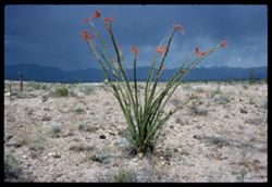
-
- Description:
- 100 f 8 tl
- Subject:
- Deserts and Flowers
- Series:
- 11-59
- Creator:
- Cushman, Charles W., 1896-1972
- Date Created:
- 1959-03-24
- Genre:
- Identification photographs
- Frame Number:
- 9
- County:
- Yuma
- Abstract:
- Flowers of
- Call Number:
- P10734
- City:
- Quartzsite
- Country:
- United States
- State/Province:
- Arizona
- Alternate Identifier:
- 1159.9
- Persistent URL:
- http://purl.dlib.indiana.edu/iudl/archives/cushman/P10734
- Holding Location:
- Bloomington - University Archives
Wells Library E460
1320 E 10th St.
Bloomington, IN 47405
Contact at archives@indiana.edu, 812-855-1127
-
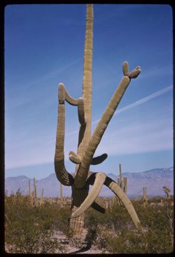
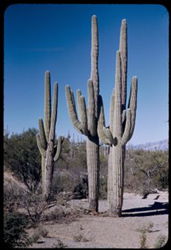
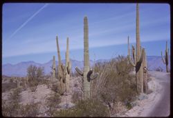
- Description:
- 25 f 12
- Subject:
- National parks & reserves, Deserts, Saguaro, Mountains, Saguaro National Park (Ariz.), Cactus, and Shrubs
- Series:
- 3-52
- Creator:
- Cushman, Charles W., 1896-1972
- Date Created:
- 1952-01-15
- Genre:
- Identification photographs
- Frame Number:
- 4
- County:
- Pima
- Abstract:
- Multi branched Sahuaro showing nobbins.
- Call Number:
- P05573
- City:
- Tucson
- Country:
- United States
- State/Province:
- Arizona
- Alternate Identifier:
- 352.4
- Persistent URL:
- http://purl.dlib.indiana.edu/iudl/archives/cushman/P05573
- Holding Location:
- Bloomington - University Archives
Wells Library E460
1320 E 10th St.
Bloomington, IN 47405
Contact at archives@indiana.edu, 812-855-1127
-
- Description:
- 200 f 8
- Subject:
- Pan American World Airways, inc., Air travel, Deserts, and Croplands
- Series:
- 1-65
- Creator:
- Cushman, Charles W., 1896-1972
- Date Created:
- 1965-03-30
- Genre:
- Aerial photographs and Landscape photographs
- Frame Number:
- 11
- Abstract:
- over high Calif desert and Over high Calif. desert en route to Las Vegas
- Call Number:
- P13875
- Country:
- United States
- State/Province:
- California
- Alternate Identifier:
- 165.11
- Persistent URL:
- http://purl.dlib.indiana.edu/iudl/archives/cushman/P13875
- Holding Location:
- Bloomington - University Archives
Wells Library E460
1320 E 10th St.
Bloomington, IN 47405
Contact at archives@indiana.edu, 812-855-1127
-
- Description:
- 100 f 11 SL
- Subject:
- Valleys, Grasses, Monument Valley (Ariz. and Utah), Deserts, Cliffs, Rock formations, and Shrubs
- Series:
- 37-65
- Creator:
- Cushman, Charles W., 1896-1972
- Date Created:
- 1965-10-09
- Genre:
- Landscape photographs
- Frame Number:
- 9
- Street Address:
- Arizona State Highway 64 and Navajo Trail
- County:
- Navajo
- Abstract:
- Red stone.
- Call Number:
- P15115
- City:
- Kayenta
- Country:
- United States
- State/Province:
- Arizona
- Alternate Identifier:
- 3765.9
- Persistent URL:
- http://purl.dlib.indiana.edu/iudl/archives/cushman/P15115
- Holding Location:
- Bloomington - University Archives
Wells Library E460
1320 E 10th St.
Bloomington, IN 47405
Contact at archives@indiana.edu, 812-855-1127
-
- Description:
- 100 f 11 SL
- Subject:
- Rock formations, Trails & paths, Grasses, Deserts, Cliffs, and Buttes
- Series:
- 37-65
- Creator:
- Cushman, Charles W., 1896-1972
- Date Created:
- 1965-10-09
- Genre:
- Landscape photographs
- Frame Number:
- 8
- Street Address:
- Arizona State Highway 64 and Navajo Trail
- County:
- Navajo
- Abstract:
- Red stone.
- Call Number:
- P15114
- City:
- Kayenta
- Country:
- United States
- State/Province:
- Arizona
- Alternate Identifier:
- 3765.8
- Persistent URL:
- http://purl.dlib.indiana.edu/iudl/archives/cushman/P15114
- Holding Location:
- Bloomington - University Archives
Wells Library E460
1320 E 10th St.
Bloomington, IN 47405
Contact at archives@indiana.edu, 812-855-1127
-
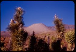
- Description:
- 100 f 11 + f 12/13
- Subject:
- Mountains, Plants, Ocotillo, Deserts, Storms, and Flowers
- Series:
- 1-66
- Creator:
- Cushman, Charles W., 1896-1972
- Date Created:
- 1966-04-22
- Genre:
- Identification photographs and Landscape photographs
- Frame Number:
- 6
- Street Address:
- United States Highway 66
- County:
- Mohave
- Abstract:
- Ocotillo along U.S. 66- Mojave county and Little red head and friend at drinking fountain - same in error
- Call Number:
- P15247
- Country:
- United States
- State/Province:
- Arizona
- Alternate Identifier:
- 166.6
- Persistent URL:
- http://purl.dlib.indiana.edu/iudl/archives/cushman/P15247
- Holding Location:
- Bloomington - University Archives
Wells Library E460
1320 E 10th St.
Bloomington, IN 47405
Contact at archives@indiana.edu, 812-855-1127
-
- Description:
- 100 f 13 ?
- Subject:
- Hills, Mountains, Plants, Ocotillo, Deserts, Storms, Flowers, Clouds, and Grasses
- Series:
- 1-66
- Creator:
- Cushman, Charles W., 1896-1972
- Date Created:
- 1966-04-22
- Genre:
- Identification photographs and Landscape photographs
- Frame Number:
- 7
- Street Address:
- United States Highway 66
- County:
- Mohave
- Abstract:
- Ocotillo along U.S. 66- Mojave county
- Call Number:
- P15248
- Country:
- United States
- State/Province:
- Arizona
- Alternate Identifier:
- 166.7
- Persistent URL:
- http://purl.dlib.indiana.edu/iudl/archives/cushman/P15248
- Holding Location:
- Bloomington - University Archives
Wells Library E460
1320 E 10th St.
Bloomington, IN 47405
Contact at archives@indiana.edu, 812-855-1127
-
- Description:
- 100 f 12?
- Subject:
- Rocks, Hills, Mountains, Grasses, Ocotillo, Deserts, Storms, Flowers, and Plants
- Series:
- 1-66
- Creator:
- Cushman, Charles W., 1896-1972
- Date Created:
- 1966-04-22
- Genre:
- Identification photographs and Landscape photographs
- Frame Number:
- 8
- Street Address:
- United States Highway 66
- County:
- Mohave
- Abstract:
- Ocotillo along U.S. 66- Mojave county
- Call Number:
- P15249
- Country:
- United States
- State/Province:
- Arizona
- Alternate Identifier:
- 166.8
- Persistent URL:
- http://purl.dlib.indiana.edu/iudl/archives/cushman/P15249
- Holding Location:
- Bloomington - University Archives
Wells Library E460
1320 E 10th St.
Bloomington, IN 47405
Contact at archives@indiana.edu, 812-855-1127
-
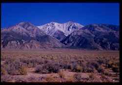
- Description:
- 50 f 11
- Subject:
- Mountains, Deserts, Shrubs, and Boundary Peak (Nev.)
- Series:
- 12-54
- Creator:
- Cushman, Charles W., 1896-1972
- Date Created:
- 1954-09-17
- Genre:
- Landscape photographs
- Frame Number:
- 4
- Street Address:
- United States Highway 6
- County:
- Esmeralda
- Abstract:
- Boundary Line Peak from north, just inside Nevada.
- Call Number:
- P07394
- Country:
- United States
- State/Province:
- Nevada
- Physical Description:
- Image was originally mounted in a glass enclosure. Before digitization, the image was removed and placed in a Wess Plastic, Inc. brand, 2" x 2", pl...
- Alternate Identifier:
- 1254.4
- Persistent URL:
- http://purl.dlib.indiana.edu/iudl/archives/cushman/P07394
- Holding Location:
- Bloomington - University Archives
Wells Library E460
1320 E 10th St.
Bloomington, IN 47405
Contact at archives@indiana.edu, 812-855-1127
-
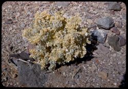
- Description:
- 25 f 16
- Subject:
- Valleys, Rocks, Death Valley (Calif. and Nev.), Deserts, and Shrubs
- Series:
- 15-52
- Creator:
- Cushman, Charles W., 1896-1972
- Date Created:
- 1952-04-09
- Genre:
- Identification photographs
- Frame Number:
- 32
- County:
- Inyo
- Abstract:
- Desert holly.
- Call Number:
- P06051
- Country:
- United States
- State/Province:
- California
- Alternate Identifier:
- 1552.32
- Persistent URL:
- http://purl.dlib.indiana.edu/iudl/archives/cushman/P06051
- Holding Location:
- Bloomington - University Archives
Wells Library E460
1320 E 10th St.
Bloomington, IN 47405
Contact at archives@indiana.edu, 812-855-1127
-
- Description:
- 100 f 11 TL
- Subject:
- Logs, Valleys, Rocks, Blue Mesa (Ariz.), Grasses, National parks & reserves, Deserts, Petrified forests, Petrified Forest National Park (Ariz.), and Hills
- Series:
- 6-63
- Creator:
- Cushman, Charles W., 1896-1972
- Date Created:
- 1963-06-27
- Genre:
- Identification photographs and Landscape photographs
- Frame Number:
- 7
- County:
- Navajo and Apache
- Abstract:
- Distantly Down from Blue Mesa
- Call Number:
- P12960
- City:
- Holbrook
- Country:
- United States
- State/Province:
- Arizona
- Alternate Identifier:
- 663.7
- Persistent URL:
- http://purl.dlib.indiana.edu/iudl/archives/cushman/P12960
- Holding Location:
- Bloomington - University Archives
Wells Library E460
1320 E 10th St.
Bloomington, IN 47405
Contact at archives@indiana.edu, 812-855-1127
-
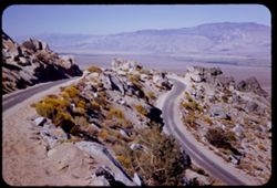
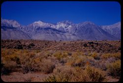
- Description:
- 50 f 11 HF
- Subject:
- Valleys, Inyo Mountains (Calif.), Mountains, Owens Valley (Calif.), Deserts, Shrubs, Roads, and Rocks
- Series:
- 12-54
- Creator:
- Cushman, Charles W., 1896-1972
- Date Created:
- 1954-09-18
- Genre:
- Landscape photographs
- Frame Number:
- 27
- Street Address:
- Mt. Whitney Road
- County:
- Inyo
- Abstract:
- Switch-back coming down Mt Whitney rd.
- Call Number:
- P07417
- Country:
- United States
- State/Province:
- California
- Alternate Identifier:
- 1254.27
- Persistent URL:
- http://purl.dlib.indiana.edu/iudl/archives/cushman/P07417
- Holding Location:
- Bloomington - University Archives
Wells Library E460
1320 E 10th St.
Bloomington, IN 47405
Contact at archives@indiana.edu, 812-855-1127
-
- Description:
- 50 f 11 sl
- Subject:
- Deserts, Mountains, Shrubs, Cactus, and Saguaro National Park (Ariz.)
- Series:
- 10-59
- Creator:
- Cushman, Charles W., 1896-1972
- Date Created:
- 1959-03-03
- Genre:
- Identification photographs
- Frame Number:
- 5
- County:
- Pima
- Abstract:
- Multi-branched Giant Sohuaro
- Call Number:
- P10693
- City:
- Tucson
- Country:
- United States
- State/Province:
- Arizona
- Alternate Identifier:
- 1059.5
- Persistent URL:
- http://purl.dlib.indiana.edu/iudl/archives/cushman/P10693
- Holding Location:
- Bloomington - University Archives
Wells Library E460
1320 E 10th St.
Bloomington, IN 47405
Contact at archives@indiana.edu, 812-855-1127
-
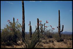
- Subject:
- Deserts, Flowers, Saguaro, Ocotillo, Mountains, Shrubs, Cactus, and Clouds
- Series:
- 4-40
- Creator:
- Cushman, Charles W., 1896-1972
- Date Created:
- 1940-04-01
- Genre:
- Identification photographs
- Frame Number:
- 18
- County:
- Pima
- Abstract:
- Desert blooms: Flaming Ocotillo: Giant Sahuaras
- Call Number:
- P01805
- Country:
- United States
- State/Province:
- Arizona
- Physical Description:
- Image was originally mounted in a glass enclosure. Before digitization, the image was removed and placed in a Wess Plastic, Inc. brand, 2" x 2", pl...
- Alternate Identifier:
- 440.18
- Persistent URL:
- http://purl.dlib.indiana.edu/iudl/archives/cushman/P01805
- Holding Location:
- Bloomington - University Archives
Wells Library E460
1320 E 10th St.
Bloomington, IN 47405
Contact at archives@indiana.edu, 812-855-1127
-
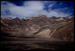
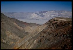
- Description:
- 25 f 11 Pola
- Subject:
- Deserts, Amargosa Range (Nev. and Calif.), Valleys, Death Valley (Calif. and Nev.), Mountains, and Rocks
- Series:
- 15-52
- Creator:
- Cushman, Charles W., 1896-1972
- Date Created:
- 1952-04-09
- Genre:
- Landscape photographs
- Frame Number:
- 27
- County:
- Inyo
- Abstract:
- Amargosa Mtns near Bad Water.
- Call Number:
- P06047
- City:
- Badwater
- Country:
- United States
- State/Province:
- California
- Physical Description:
- Image was originally mounted in a glass enclosure. Before digitization, the image was removed and placed in a Wess Plastic, Inc. brand, 2" x 2", pl...
- Alternate Identifier:
- 1552.27
- Persistent URL:
- http://purl.dlib.indiana.edu/iudl/archives/cushman/P06047
- Holding Location:
- Bloomington - University Archives
Wells Library E460
1320 E 10th St.
Bloomington, IN 47405
Contact at archives@indiana.edu, 812-855-1127
-
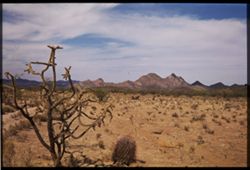
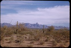
- Subject:
- Deserts, Roskruge Mountains (Ariz.), Mountains, Shrubs, Cactus, and Clouds
- Series:
- 5-40
- Creator:
- Cushman, Charles W., 1896-1972
- Date Created:
- 1940-05-01
- Genre:
- Landscape photographs
- Frame Number:
- 17
- County:
- Pima
- Abstract:
- An Arizona desert . Roskruge Mtns. In distance. View is northeast.
- Call Number:
- P01835
- Country:
- United States
- State/Province:
- Arizona
- Physical Description:
- Image was originally mounted in a glass enclosure. Before digitization, the image was removed and placed in a Wess Plastic, Inc. brand, 2" x 2", pl...
- Alternate Identifier:
- 540.17
- Persistent URL:
- http://purl.dlib.indiana.edu/iudl/archives/cushman/P01835
- Holding Location:
- Bloomington - University Archives
Wells Library E460
1320 E 10th St.
Bloomington, IN 47405
Contact at archives@indiana.edu, 812-855-1127
-
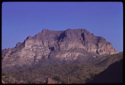
- Description:
- 100 f 13 TL
- Subject:
- Erosion, National parks & reserves, Deserts, Valleys, Hills, Cliffs, Blue Mesa (Ariz.), Rock formations, Mesas, Petrified Forest National Park (Ariz.), a...
- Series:
- 6-63
- Creator:
- Cushman, Charles W., 1896-1972
- Date Created:
- 1963-06-27
- Genre:
- Landscape photographs
- Frame Number:
- 1
- County:
- Navajo and Apache
- Abstract:
- Cliff of Blue Mesa
- Call Number:
- P12954
- City:
- Holbrook
- Country:
- United States
- State/Province:
- Arizona
- Alternate Identifier:
- 663.1
- Persistent URL:
- http://purl.dlib.indiana.edu/iudl/archives/cushman/P12954
- Holding Location:
- Bloomington - University Archives
Wells Library E460
1320 E 10th St.
Bloomington, IN 47405
Contact at archives@indiana.edu, 812-855-1127
-
- Description:
- 100 f 9 TL
- Subject:
- Deserts, Mojave Desert (Calif.), Hills, Mountains, and Tehachapi Mountains (Calif.)
- Series:
- 3-69
- Creator:
- Cushman, Charles W., 1896-1972
- Date Created:
- 1969-03-21
- Genre:
- Landscape photographs
- Frame Number:
- 16
- Street Address:
- California State Highway 14
- County:
- Los Angeles and Kern
- Abstract:
- Toward Tehachapi Mtns from Hwy 14
- Call Number:
- P15768
- City:
- Mojave and Lancaster
- Country:
- United States
- State/Province:
- California
- Alternate Identifier:
- 369.16
- Persistent URL:
- http://purl.dlib.indiana.edu/iudl/archives/cushman/P15768
- Holding Location:
- Bloomington - University Archives
Wells Library E460
1320 E 10th St.
Bloomington, IN 47405
Contact at archives@indiana.edu, 812-855-1127
-
- Description:
- 50 f 9
- Subject:
- National parks & reserves, Deserts, Devils Garden (Grand County, Utah), Hills, Sand, Mountains, Shrubs, Arches National Park (Utah), Wildflowers, Rock fo...
- Series:
- 27-52
- Creator:
- Cushman, Charles W., 1896-1972
- Date Created:
- 1952-11-04
- Genre:
- Landscape photographs
- Frame Number:
- 21
- County:
- Grand
- Abstract:
- En route to Devil's Garden. Sandstone Dunes.
- Call Number:
- P06466
- Country:
- United States
- State/Province:
- Utah
- Alternate Identifier:
- 2752.21
- Persistent URL:
- http://purl.dlib.indiana.edu/iudl/archives/cushman/P06466
- Holding Location:
- Bloomington - University Archives
Wells Library E460
1320 E 10th St.
Bloomington, IN 47405
Contact at archives@indiana.edu, 812-855-1127
-
- Description:
- 100 f 11 TL
- Subject:
- Petrified Forest National Park (Ariz.), National parks & reserves, Deserts, Valleys, Hills, Blue Mesa (Ariz.), Rivers, Mesas, Petrified forests, Erosion,...
- Series:
- 6-63
- Creator:
- Cushman, Charles W., 1896-1972
- Date Created:
- 1963-06-27
- Genre:
- Landscape photographs
- Frame Number:
- 11
- County:
- Navajo and Apache
- Abstract:
- Distantly Down from Blue Mesa
- Call Number:
- P12964
- City:
- Holbrook
- Country:
- United States
- State/Province:
- Arizona
- Alternate Identifier:
- 663.11
- Persistent URL:
- http://purl.dlib.indiana.edu/iudl/archives/cushman/P12964
- Holding Location:
- Bloomington - University Archives
Wells Library E460
1320 E 10th St.
Bloomington, IN 47405
Contact at archives@indiana.edu, 812-855-1127
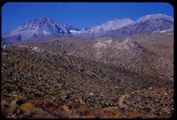
-
- Description:
- 50 f 11 HF
- Subject:
- Deserts, Striped Mountain (Inyo County, Calif.), Mountains, and Shrubs
- Series:
- 12-54
- Creator:
- Cushman, Charles W., 1896-1972
- Date Created:
- 1954-09-18
- Genre:
- Landscape photographs
- Frame Number:
- 15
- Street Address:
- United States Highway 395 and United States Highway 6
- County:
- Inyo
- Abstract:
- High Sierra wall including Striped Mtn. - 13,160 ft. seen from US 6 - 395 about 10 mi. south of Big Pine.
- Call Number:
- P07405
- City:
- Big Pine
- Country:
- United States
- State/Province:
- California
- Alternate Identifier:
- 1254.15
- Persistent URL:
- http://purl.dlib.indiana.edu/iudl/archives/cushman/P07405
- Holding Location:
- Bloomington - University Archives
Wells Library E460
1320 E 10th St.
Bloomington, IN 47405
Contact at archives@indiana.edu, 812-855-1127
-
- Description:
- 50 f 11
- Subject:
- Deserts, Glacier Lodge (Calif.), Mountains, Shrubs, Sierra Nevada (Calif. and Nev.), and Middle Palisade Glacier (Calif.)
- Series:
- 12-54
- Creator:
- Cushman, Charles W., 1896-1972
- Date Created:
- 1954-09-18
- Genre:
- Landscape photographs
- Frame Number:
- 13
- Street Address:
- Glacier Lodge Road
- County:
- Inyo
- Abstract:
- Looking SW up Glacier Lodge road at 1020 am DST.
- Call Number:
- P07403
- City:
- Big Pine
- Country:
- United States
- State/Province:
- California
- Alternate Identifier:
- 1254.13
- Persistent URL:
- http://purl.dlib.indiana.edu/iudl/archives/cushman/P07403
- Holding Location:
- Bloomington - University Archives
Wells Library E460
1320 E 10th St.
Bloomington, IN 47405
Contact at archives@indiana.edu, 812-855-1127
-
- Description:
- 100 f 8 tl 5 1/2 ft
- Subject:
- Deserts, Mojave Desert (Calif.), and Wildflowers
- Series:
- 7-55
- Creator:
- Cushman, Charles W., 1896-1972
- Date Created:
- 1955-03-21
- Genre:
- Identification photographs
- Frame Number:
- 25
- County:
- San Bernardino
- Abstract:
- Tiny blue flowers from 5 1/2 ft
- Call Number:
- P07749
- Country:
- United States
- State/Province:
- California
- Alternate Identifier:
- 755.25
- Persistent URL:
- http://purl.dlib.indiana.edu/iudl/archives/cushman/P07749
- Holding Location:
- Bloomington - University Archives
Wells Library E460
1320 E 10th St.
Bloomington, IN 47405
Contact at archives@indiana.edu, 812-855-1127
-
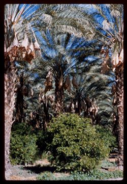
- Description:
- 25 f 8
- Subject:
- Deserts, Date palm, Shrubs, Trees, and Palms
- Series:
- 26-60
- Creator:
- Cushman, Charles W., 1896-1972
- Date Created:
- 1960-12-25
- Genre:
- Identification photographs
- Frame Number:
- 21
- County:
- Riverside
- Abstract:
- Date Palm grove near Thousand Palms
- Call Number:
- P11743
- City:
- Thousand Palms
- Country:
- United States
- State/Province:
- California
- Alternate Identifier:
- 2660.21
- Persistent URL:
- http://purl.dlib.indiana.edu/iudl/archives/cushman/P11743
- Holding Location:
- Bloomington - University Archives
Wells Library E460
1320 E 10th St.
Bloomington, IN 47405
Contact at archives@indiana.edu, 812-855-1127
-
- Description:
- 50 f 8
- Subject:
- Deserts, Valleys, Glacier Lodge (Calif.), Roads, Mountains, Shrubs, Trees, Rocks, and Owens Valley (Calif.)
- Series:
- 12-54
- Creator:
- Cushman, Charles W., 1896-1972
- Date Created:
- 1954-09-18
- Genre:
- Landscape photographs
- Frame Number:
- 12
- Street Address:
- Glacier Lodge Road
- County:
- Inyo
- Abstract:
- Looking down on Big Pine from Glacier Lodge road.
- Call Number:
- P07402
- City:
- Big Pine
- Country:
- United States
- State/Province:
- California
- Alternate Identifier:
- 1254.12
- Persistent URL:
- http://purl.dlib.indiana.edu/iudl/archives/cushman/P07402
- Holding Location:
- Bloomington - University Archives
Wells Library E460
1320 E 10th St.
Bloomington, IN 47405
Contact at archives@indiana.edu, 812-855-1127
-
- Description:
- 100 f 11TL
- Subject:
- Petrified Forest National Park (Ariz.), National parks & reserves, Deserts, Cliffs, Blue Mesa (Ariz.), Rock formations, Mesas, and Petrified forests
- Series:
- 6-63
- Creator:
- Cushman, Charles W., 1896-1972
- Date Created:
- 1963-06-27
- Genre:
- Landscape photographs
- Frame Number:
- 5
- County:
- Navajo and Apache
- Abstract:
- Down from Blue Mesa
- Call Number:
- P12958
- City:
- Holbrook
- Country:
- United States
- State/Province:
- Arizona
- Alternate Identifier:
- 663.5
- Persistent URL:
- http://purl.dlib.indiana.edu/iudl/archives/cushman/P12958
- Holding Location:
- Bloomington - University Archives
Wells Library E460
1320 E 10th St.
Bloomington, IN 47405
Contact at archives@indiana.edu, 812-855-1127
-

- Description:
- 25 f 14
- Subject:
- Deserts, Amargosa Range (Nev. and Calif.), Valleys, Hills, Death Valley (Calif. and Nev.), Cliffs, Mountains, Shrubs, Rocks, Canyons, and Desolation Canyon (...
- Series:
- 15-52
- Creator:
- Cushman, Charles W., 1896-1972
- Date Created:
- 1952-04-09
- Genre:
- Landscape photographs
- Frame Number:
- 21
- Street Address:
- Bad Water Road
- County:
- Inyo
- Abstract:
- Approx. same.
- Call Number:
- P06041
- City:
- Furnace Creek
- Country:
- United States
- State/Province:
- California
- Alternate Identifier:
- 1552.21
- Persistent URL:
- http://purl.dlib.indiana.edu/iudl/archives/cushman/P06041
- Holding Location:
- Bloomington - University Archives
Wells Library E460
1320 E 10th St.
Bloomington, IN 47405
Contact at archives@indiana.edu, 812-855-1127
-
- Description:
- 100 f 8 tl
- Subject:
- Deserts, Hills, Mountains, Picketpost Mountain (Ariz.), and Cactus
- Series:
- 10-59
- Creator:
- Cushman, Charles W., 1896-1972
- Date Created:
- 1959-02-27
- Frame Number:
- 1
- County:
- Pinal
- Abstract:
- Pickett Post Mtn.
- Call Number:
- P10689
- City:
- Superior
- Country:
- United States
- State/Province:
- Arizona
- Alternate Identifier:
- 1059.1
- Persistent URL:
- http://purl.dlib.indiana.edu/iudl/archives/cushman/P10689
- Holding Location:
- Bloomington - University Archives
Wells Library E460
1320 E 10th St.
Bloomington, IN 47405
Contact at archives@indiana.edu, 812-855-1127
-

- Description:
- 25 f 9 Pola
- Subject:
- Deserts, Valleys, Hills, Death Valley (Calif. and Nev.), Mountains, Colored mountains, Rocks, Rock formations, and Black Mountains (Inyo County, Calif.)
- Series:
- 15-52
- Creator:
- Cushman, Charles W., 1896-1972
- Date Created:
- 1952-04-09
- Genre:
- Landscape photographs
- Frame Number:
- 23
- County:
- Inyo
- Abstract:
- Colored Mtns. The Black Mtns.
- Call Number:
- P06043
- Country:
- United States
- State/Province:
- California
- Alternate Identifier:
- 1552.23
- Persistent URL:
- http://purl.dlib.indiana.edu/iudl/archives/cushman/P06043
- Holding Location:
- Bloomington - University Archives
Wells Library E460
1320 E 10th St.
Bloomington, IN 47405
Contact at archives@indiana.edu, 812-855-1127
-
- Description:
- 100 f 8 tl
- Subject:
- Deserts, Mountains, Dirt roads, Shrubs, Picacho Mountains (Ariz.), and Fences
- Series:
- 10-59
- Creator:
- Cushman, Charles W., 1896-1972
- Date Created:
- 1959-03-22
- Genre:
- Landscape photographs
- Frame Number:
- 31
- County:
- Pima and Pinal
- Abstract:
- Picacho, near Red Rock
- Call Number:
- P10719
- City:
- Tucson and Red Rock
- Country:
- United States
- State/Province:
- Arizona
- Alternate Identifier:
- 1059.31
- Persistent URL:
- http://purl.dlib.indiana.edu/iudl/archives/cushman/P10719
- Holding Location:
- Bloomington - University Archives
Wells Library E460
1320 E 10th St.
Bloomington, IN 47405
Contact at archives@indiana.edu, 812-855-1127
-
- Description:
- 100 f 8
- Subject:
- Petrified Forest National Park (Ariz.), National parks & reserves, Deserts, Valleys, Hills, Painted Desert (Ariz.), Shrubs, and Mesas
- Series:
- 5-63
- Creator:
- Cushman, Charles W., 1896-1972
- Date Created:
- 1963-06-26
- Genre:
- Landscape photographs
- Frame Number:
- 23
- County:
- Navajo and Apache
- Abstract:
- Painted Desert near Holbrook, Ariz
- Call Number:
- P12939
- City:
- Holbrook
- Country:
- United States
- State/Province:
- Arizona
- Alternate Identifier:
- 563.23
- Persistent URL:
- http://purl.dlib.indiana.edu/iudl/archives/cushman/P12939
- Holding Location:
- Bloomington - University Archives
Wells Library E460
1320 E 10th St.
Bloomington, IN 47405
Contact at archives@indiana.edu, 812-855-1127
-
- Description:
- 50 f 8
- Subject:
- Baboquivari Peak (Ariz.), Deserts, Mountains, Shrubs, and Cactus
- Series:
- 2-52
- Creator:
- Cushman, Charles W., 1896-1972
- Date Created:
- 1952-01-09
- Genre:
- Landscape photographs
- Frame Number:
- 10
- Street Address:
- San Miguel Road
- County:
- Pima
- Abstract:
- Baboquivari Pk from Sells - San Miguel Rd.
- Call Number:
- P05540
- City:
- Sells
- Country:
- United States
- State/Province:
- Arizona
- Alternate Identifier:
- 252.10
- Persistent URL:
- http://purl.dlib.indiana.edu/iudl/archives/cushman/P05540
- Holding Location:
- Bloomington - University Archives
Wells Library E460
1320 E 10th St.
Bloomington, IN 47405
Contact at archives@indiana.edu, 812-855-1127
-
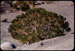
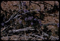
- Description:
- 100 f 6.3 tl 35 ft
- Subject:
- Deserts, Death Valley National Park (Calif. and Nev.), Furnace Creek Wash (Calif.), Shrubs, and Rocks
- Series:
- 10-55
- Creator:
- Cushman, Charles W., 1896-1972
- Date Created:
- 1955-03-23
- Genre:
- Identification photographs
- Frame Number:
- 25
- County:
- Inyo
- Abstract:
- Desert bush
- Call Number:
- P07850
- Country:
- United States
- State/Province:
- California
- Alternate Identifier:
- 1055.25
- Persistent URL:
- http://purl.dlib.indiana.edu/iudl/archives/cushman/P07850
- Holding Location:
- Bloomington - University Archives
Wells Library E460
1320 E 10th St.
Bloomington, IN 47405
Contact at archives@indiana.edu, 812-855-1127
-
- Description:
- 50 f 8
- Subject:
- National parks & reserves, Deserts, Saguaro, Shrubs, Cactus, and Saguaro National Park (Ariz.)
- Series:
- 3-52
- Creator:
- Cushman, Charles W., 1896-1972
- Date Created:
- 1952-01-15
- Genre:
- Identification photographs
- Frame Number:
- 1
- County:
- Pima
- Abstract:
- Sahuaro group = in Sahuaro Nat'l Mon.
- Call Number:
- P05570
- City:
- Tucson and Tanque Verde
- Country:
- United States
- State/Province:
- Arizona
- Alternate Identifier:
- 352.1
- Persistent URL:
- http://purl.dlib.indiana.edu/iudl/archives/cushman/P05570
- Holding Location:
- Bloomington - University Archives
Wells Library E460
1320 E 10th St.
Bloomington, IN 47405
Contact at archives@indiana.edu, 812-855-1127
-
- Description:
- 25 f 9 Pola
- Subject:
- Lakes & ponds, Deserts, Valleys, Death Valley (Calif. and Nev.), Roads, Cliffs, Mountains, Boulders, and Rocks
- Series:
- 15-52
- Creator:
- Cushman, Charles W., 1896-1972
- Date Created:
- 1952-04-09
- Genre:
- Snapshots
- Frame Number:
- 29
- County:
- Inyo
- Abstract:
- Mtns at Bad Water, 279.6 ft. below
- Call Number:
- P06049
- City:
- Badwater
- Country:
- United States
- State/Province:
- California
- Alternate Identifier:
- 1552.29
- Persistent URL:
- http://purl.dlib.indiana.edu/iudl/archives/cushman/P06049
- Holding Location:
- Bloomington - University Archives
Wells Library E460
1320 E 10th St.
Bloomington, IN 47405
Contact at archives@indiana.edu, 812-855-1127
-
- Description:
- 25 f 9
- Subject:
- Panamint Mountains (Calif.), Deserts, Canyons, Valleys, Death Valley (Calif. and Nev.), Panamint Valley (Calif.), Mountains, Cliffs, and Panamint Range (Calif.)
- Series:
- 15-52
- Creator:
- Cushman, Charles W., 1896-1972
- Date Created:
- 1952-04-01
- Genre:
- Landscape photographs
- Frame Number:
- 3
- County:
- Inyo
- Abstract:
- Mouth of Canyon into Panamint Valley - Panamint Mtns in distance.
- Call Number:
- P06024
- Country:
- United States
- State/Province:
- California
- Physical Description:
- Image was originally mounted in a glass enclosure. Before digitization, the image was removed and placed in a Wess Plastic, Inc. brand, 2" x 2", pl...
- Alternate Identifier:
- 1552.3
- Persistent URL:
- http://purl.dlib.indiana.edu/iudl/archives/cushman/P06024
- Holding Location:
- Bloomington - University Archives
Wells Library E460
1320 E 10th St.
Bloomington, IN 47405
Contact at archives@indiana.edu, 812-855-1127
-
- Description:
- 50 f 8 sl
- Subject:
- Deserts, Trees, Saguaro National Park (Ariz.), and Leaves
- Series:
- 10-59
- Creator:
- Cushman, Charles W., 1896-1972
- Date Created:
- 1959-03-05
- Genre:
- Identification photographs
- Frame Number:
- 14
- County:
- Pima
- Abstract:
- Foliage of Mesquite
- Call Number:
- P10702
- City:
- Tucson
- Country:
- United States
- State/Province:
- Arizona
- Alternate Identifier:
- 1059.14
- Persistent URL:
- http://purl.dlib.indiana.edu/iudl/archives/cushman/P10702
- Holding Location:
- Bloomington - University Archives
Wells Library E460
1320 E 10th St.
Bloomington, IN 47405
Contact at archives@indiana.edu, 812-855-1127
-
- Description:
- 25 f 13
- Subject:
- Deserts, Mojave Desert (Calif.), Walker Pass (Calif.), Joshua trees, Mountains, Shrubs, and Hills
- Series:
- 12-54
- Creator:
- Cushman, Charles W., 1896-1972
- Date Created:
- 1954-09-18
- Genre:
- Identification photographs
- Frame Number:
- 30
- Street Address:
- California State Highway 178 and Walker Pass Road
- County:
- Kern
- Abstract:
- Joshua trees along Walker Pass Rd.
- Call Number:
- P07420
- Country:
- United States
- State/Province:
- California
- Alternate Identifier:
- 1254.30
- Persistent URL:
- http://purl.dlib.indiana.edu/iudl/archives/cushman/P07420
- Holding Location:
- Bloomington - University Archives
Wells Library E460
1320 E 10th St.
Bloomington, IN 47405
Contact at archives@indiana.edu, 812-855-1127
-
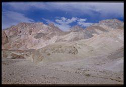
- Description:
- 50 mm lens
- Subject:
- Deserts, Craters, Valleys, Dantes View (Calif.), Mountains, Clouds, Death Valley (Calif. and Nev.), and Black Mountains (Inyo County, Calif.)
- Series:
- 3-55
- Creator:
- Cushman, Charles W., 1896-1972
- Date Created:
- 1955-02-27
- Genre:
- Landscape photographs
- Frame Number:
- 4
- County:
- Inyo
- Abstract:
- West across floor of Death Valley
- Call Number:
- P07597
- Country:
- United States
- State/Province:
- California
- Alternate Identifier:
- 355.4
- Persistent URL:
- http://purl.dlib.indiana.edu/iudl/archives/cushman/P07597
- Holding Location:
- Bloomington - University Archives
Wells Library E460
1320 E 10th St.
Bloomington, IN 47405
Contact at archives@indiana.edu, 812-855-1127
-
- Description:
- 50 f 9 sl
- Subject:
- Deserts, Deterioration, Cactus, Mountains, Shrubs, and Saguaro National Park (Ariz.)
- Series:
- 10-59
- Creator:
- Cushman, Charles W., 1896-1972
- Date Created:
- 1959-03-03
- Genre:
- Identification photographs
- Frame Number:
- 6
- County:
- Pima
- Abstract:
- A skeleton
- Call Number:
- P10694
- City:
- Tucson
- Country:
- United States
- State/Province:
- Arizona
- Alternate Identifier:
- 1059.6
- Persistent URL:
- http://purl.dlib.indiana.edu/iudl/archives/cushman/P10694
- Holding Location:
- Bloomington - University Archives
Wells Library E460
1320 E 10th St.
Bloomington, IN 47405
Contact at archives@indiana.edu, 812-855-1127
-
- Subject:
- Deserts, Channels, Air France, Air travel, Land, and Rivers
- Series:
- 3-60
- Creator:
- Cushman, Charles W., 1896-1972
- Date Created:
- 1960-05-07
- Genre:
- Aerial photographs and Landscape photographs
- Frame Number:
- 14
- Abstract:
- River
- Call Number:
- P10974
- Country:
- United States
- Alternate Identifier:
- 360.14
- Persistent URL:
- http://purl.dlib.indiana.edu/iudl/archives/cushman/P10974
- Holding Location:
- Bloomington - University Archives
Wells Library E460
1320 E 10th St.
Bloomington, IN 47405
Contact at archives@indiana.edu, 812-855-1127
-
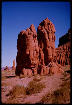
- Description:
- 100 f 11 TL
- Subject:
- Deserts, Cliffs, Buttes, and Rock formations
- Series:
- 37-65
- Creator:
- Cushman, Charles W., 1896-1972
- Date Created:
- 1965-10-09
- Genre:
- Landscape photographs
- Frame Number:
- 13
- Street Address:
- Arizona State Highway 64
- County:
- Navajo
- Abstract:
- Church Rock.
- Call Number:
- P15119
- City:
- Kayenta
- Country:
- United States
- State/Province:
- Arizona
- Alternate Identifier:
- 3765.13
- Persistent URL:
- http://purl.dlib.indiana.edu/iudl/archives/cushman/P15119
- Holding Location:
- Bloomington - University Archives
Wells Library E460
1320 E 10th St.
Bloomington, IN 47405
Contact at archives@indiana.edu, 812-855-1127
-
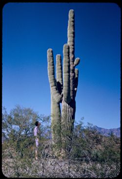
- Description:
- 25 f 12
- Subject:
- Deserts, Cactus, Mountains, National parks & reserves, Saguaro, Saguaro National Park (Ariz.), Women, and Shrubs
- Series:
- 3-52
- Creator:
- Cushman, Charles W., 1896-1972
- Date Created:
- 1952-01-15
- Genre:
- Portraits and Identification photographs
- Frame Number:
- 5
- County:
- Pima
- Persons Pictured:
- Cushman, Jean
- Abstract:
- Jean look at tall sahuaro.
- Call Number:
- P05574
- City:
- Tucson
- Country:
- United States
- State/Province:
- Arizona
- Alternate Identifier:
- 352.5
- Persistent URL:
- http://purl.dlib.indiana.edu/iudl/archives/cushman/P05574
- Holding Location:
- Bloomington - University Archives
Wells Library E460
1320 E 10th St.
Bloomington, IN 47405
Contact at archives@indiana.edu, 812-855-1127
-
- Description:
- 50 f 11 sl
- Subject:
- Deserts, Roads, Cactus, Mountains, Shrubs, and Saguaro National Park (Ariz.)
- Series:
- 10-59
- Creator:
- Cushman, Charles W., 1896-1972
- Date Created:
- 1959-03-03
- Frame Number:
- 3
- County:
- Pima
- Abstract:
- View north
- Call Number:
- P10691
- City:
- Tucson
- Country:
- United States
- State/Province:
- Arizona
- Alternate Identifier:
- 1059.3
- Persistent URL:
- http://purl.dlib.indiana.edu/iudl/archives/cushman/P10691
- Holding Location:
- Bloomington - University Archives
Wells Library E460
1320 E 10th St.
Bloomington, IN 47405
Contact at archives@indiana.edu, 812-855-1127
-

- Description:
- 25 f 13
- Subject:
- Rocks, Colored mountains, Valleys, Cliffs, Mountains, Rock formations, Death Valley (Calif. and Nev.), Deserts, and Hills
- Series:
- 15-52
- Creator:
- Cushman, Charles W., 1896-1972
- Date Created:
- 1952-04-09
- Genre:
- Landscape photographs
- Frame Number:
- 38
- Street Address:
- Artists Drive
- County:
- Inyo
- Abstract:
- From top of Artists Drive. Off Artists Drive.
- Call Number:
- P06057
- Country:
- United States
- State/Province:
- California
- Alternate Identifier:
- 1552.38
- Persistent URL:
- http://purl.dlib.indiana.edu/iudl/archives/cushman/P06057
- Holding Location:
- Bloomington - University Archives
Wells Library E460
1320 E 10th St.
Bloomington, IN 47405
Contact at archives@indiana.edu, 812-855-1127
-
- Description:
- 25 f 13
- Subject:
- Deserts, Valleys, Mountains, Hills, Rocks, and Death Valley (Calif. and Nev.)
- Series:
- 15-52
- Creator:
- Cushman, Charles W., 1896-1972
- Date Created:
- 1952-04-09
- Genre:
- Landscape photographs
- Frame Number:
- 31
- Street Address:
- Artists Drive
- County:
- Inyo
- Abstract:
- Mtns from Atrists Drive.
- Call Number:
- P06050
- Country:
- United States
- State/Province:
- California
- Physical Description:
- Image was originally mounted in a glass enclosure. Before digitization, the image was removed and placed in a Wess Plastic, Inc. brand, 2" x 2", pl...
- Alternate Identifier:
- 1552.31
- Persistent URL:
- http://purl.dlib.indiana.edu/iudl/archives/cushman/P06050
- Holding Location:
- Bloomington - University Archives
Wells Library E460
1320 E 10th St.
Bloomington, IN 47405
Contact at archives@indiana.edu, 812-855-1127