
Search Constraints
You searched for:
Campus
IUB
Remove constraint Campus: IUB
Subject
Rock formations
Remove constraint Subject: Rock formations
State/Province
Colorado
Remove constraint State/Province: Colorado
« Previous |
1 - 100 of 115
|
Next »
Search Results
-
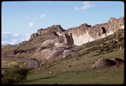
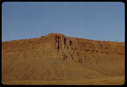
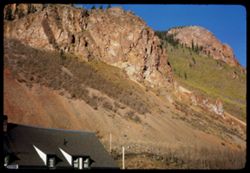
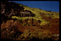
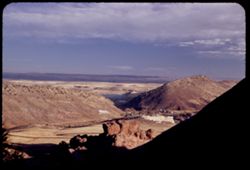
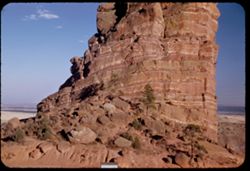
- Description:
- 100 f 11 tl
- Subject:
- Rocks, Cliffs, Grazing, Trees, Mining, Cattle, Mountains, Rock formations, Clouds, Utility poles, and Roads
- Series:
- 9-66
- Creator:
- Cushman, Charles W., 1896-1972
- Date Created:
- 1966-06-14
- Genre:
- Landscape photographs
- Frame Number:
- 23
- Street Address:
- Colorado State Highway 93
- County:
- Jefferson and Boulder
- Call Number:
- P15426
- City:
- Golden and Boulder
- Country:
- United States
- State/Province:
- Colorado
- Alternate Identifier:
- 966.23
- Persistent URL:
- http://purl.dlib.indiana.edu/iudl/archives/cushman/P15426
- Holding Location:
- Bloomington - University Archives
Wells Library E460
1320 E 10th St.
Bloomington, IN 47405
Contact at archives@indiana.edu, 812-855-1127
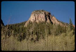
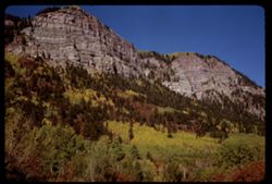
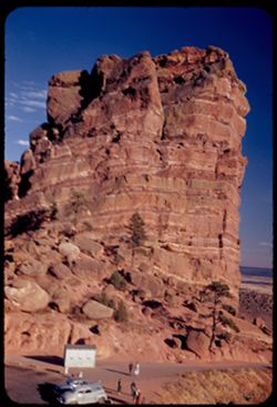
-
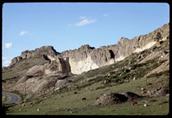
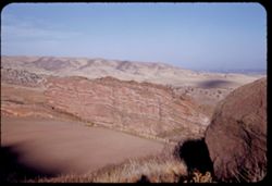
- Description:
- 100 f 11 tl
- Subject:
- Rocks, Cliffs, Grazing, Mining, Cattle, Mountains, Rock formations, Utility poles, Roads, and Shrubs
- Series:
- 9-66
- Creator:
- Cushman, Charles W., 1896-1972
- Date Created:
- 1966-06-14
- Genre:
- Landscape photographs
- Frame Number:
- 22
- Street Address:
- Colorado State Highway 93
- County:
- Jefferson and Boulder
- Call Number:
- P15425
- City:
- Golden and Boulder
- Country:
- United States
- State/Province:
- Colorado
- Alternate Identifier:
- 966.22
- Persistent URL:
- http://purl.dlib.indiana.edu/iudl/archives/cushman/P15425
- Holding Location:
- Bloomington - University Archives
Wells Library E460
1320 E 10th St.
Bloomington, IN 47405
Contact at archives@indiana.edu, 812-855-1127
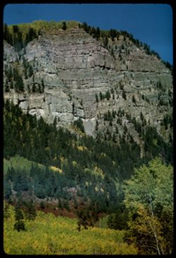
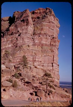
-
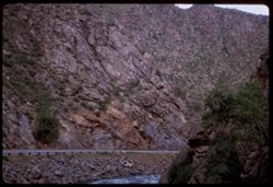
- Description:
- 100 f 4.5
- Subject:
- Canyons, Roads, Cliffs, Trees, Rocks, Clear Creek (Clear Creek County, Colo.), Rivers, Clear Creek Canyon (Colo.), and Rock formations
- Series:
- 9-66
- Creator:
- Cushman, Charles W., 1896-1972
- Date Created:
- 1966-06-13
- Genre:
- Landscape photographs
- Frame Number:
- 14
- County:
- Clear Creek
- Call Number:
- P15417
- Country:
- United States
- State/Province:
- Colorado
- Alternate Identifier:
- 966.14
- Persistent URL:
- http://purl.dlib.indiana.edu/iudl/archives/cushman/P15417
- Holding Location:
- Bloomington - University Archives
Wells Library E460
1320 E 10th St.
Bloomington, IN 47405
Contact at archives@indiana.edu, 812-855-1127
-
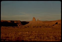
- Description:
- 100 f 16 TL
- Subject:
- Erosion, Plains, Canyons, Grasses, Mesas, and Rock formations
- Series:
- 36-65
- Creator:
- Cushman, Charles W., 1896-1972
- Date Created:
- 1965-10-07
- Genre:
- Landscape photographs
- Frame Number:
- 22
- Street Address:
- United States Highway 666
- County:
- Montezuma
- Abstract:
- Squaw + papoose along Hwy 666.
- Call Number:
- P15090
- City:
- Cortez
- Country:
- United States
- State/Province:
- Colorado
- Alternate Identifier:
- 3665.22
- Persistent URL:
- http://purl.dlib.indiana.edu/iudl/archives/cushman/P15090
- Holding Location:
- Bloomington - University Archives
Wells Library E460
1320 E 10th St.
Bloomington, IN 47405
Contact at archives@indiana.edu, 812-855-1127
-
- Description:
- 100 f 16 TL
- Subject:
- Erosion, Sand, Buttes, Rock formations, Mesas, and Cliffs
- Series:
- 36-65
- Creator:
- Cushman, Charles W., 1896-1972
- Date Created:
- 1965-10-07
- Genre:
- Landscape photographs
- Frame Number:
- 21
- Street Address:
- United States Highway 666
- County:
- Montezuma
- Abstract:
- Sad rock.
- Call Number:
- P15089
- City:
- Cortez
- Country:
- United States
- State/Province:
- Colorado
- Alternate Identifier:
- 3665.21
- Persistent URL:
- http://purl.dlib.indiana.edu/iudl/archives/cushman/P15089
- Holding Location:
- Bloomington - University Archives
Wells Library E460
1320 E 10th St.
Bloomington, IN 47405
Contact at archives@indiana.edu, 812-855-1127
-
- Description:
- 100 f 16 TL
- Subject:
- Erosion, Cliffs, Buttes, Rock formations, and Mesas
- Series:
- 36-65
- Creator:
- Cushman, Charles W., 1896-1972
- Date Created:
- 1965-10-07
- Genre:
- Landscape photographs
- Frame Number:
- 20
- Street Address:
- United States Highway 666
- County:
- Montezuma
- Abstract:
- Sad rock
- Call Number:
- P15088
- City:
- Cortez
- Country:
- United States
- State/Province:
- Colorado
- Alternate Identifier:
- 3665.20
- Persistent URL:
- http://purl.dlib.indiana.edu/iudl/archives/cushman/P15088
- Holding Location:
- Bloomington - University Archives
Wells Library E460
1320 E 10th St.
Bloomington, IN 47405
Contact at archives@indiana.edu, 812-855-1127
-
- Description:
- 100 f 16 TL
- Subject:
- Plains, Cliffs, Buttes, Rock formations, Mesas, and Grasses
- Series:
- 36-65
- Creator:
- Cushman, Charles W., 1896-1972
- Date Created:
- 1965-10-07
- Genre:
- Landscape photographs
- Frame Number:
- 19
- Street Address:
- United States Highway 666
- County:
- Montezuma
- Abstract:
- Sad rock.
- Call Number:
- P15087
- City:
- Cortez
- Country:
- United States
- State/Province:
- Colorado
- Alternate Identifier:
- 3665.19
- Persistent URL:
- http://purl.dlib.indiana.edu/iudl/archives/cushman/P15087
- Holding Location:
- Bloomington - University Archives
Wells Library E460
1320 E 10th St.
Bloomington, IN 47405
Contact at archives@indiana.edu, 812-855-1127
-
- Description:
- 100 f 11 TL
- Subject:
- Erosion, Cliffs, Electric lines, Rock formations, Mesas, and Sand
- Series:
- 36-65
- Creator:
- Cushman, Charles W., 1896-1972
- Date Created:
- 1965-10-07
- Genre:
- Landscape photographs
- Frame Number:
- 18
- Street Address:
- United States Highway 666
- County:
- Montezuma
- Abstract:
- Corner of fine Mesa in Colo. from N.W.
- Call Number:
- P15086
- City:
- Cortez
- Country:
- United States
- State/Province:
- Colorado
- Alternate Identifier:
- 3665.18
- Persistent URL:
- http://purl.dlib.indiana.edu/iudl/archives/cushman/P15086
- Holding Location:
- Bloomington - University Archives
Wells Library E460
1320 E 10th St.
Bloomington, IN 47405
Contact at archives@indiana.edu, 812-855-1127
-
- Description:
- 100 f 11 TL
- Subject:
- Erosion, Sand, Rock formations, Mesas, and Cliffs
- Series:
- 36-65
- Creator:
- Cushman, Charles W., 1896-1972
- Date Created:
- 1965-10-07
- Genre:
- Landscape photographs
- Frame Number:
- 17
- Street Address:
- United States Highway 666
- County:
- Montezuma
- Abstract:
- Corner of fine Mesa in Colo.
- Call Number:
- P15085
- City:
- Cortez
- Country:
- United States
- State/Province:
- Colorado
- Alternate Identifier:
- 3665.17
- Persistent URL:
- http://purl.dlib.indiana.edu/iudl/archives/cushman/P15085
- Holding Location:
- Bloomington - University Archives
Wells Library E460
1320 E 10th St.
Bloomington, IN 47405
Contact at archives@indiana.edu, 812-855-1127
-
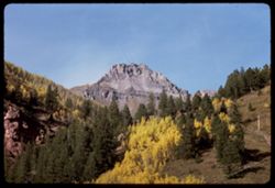
- Description:
- 100 f 11 TL
- Subject:
- Forests, Cliffs, San Juan Mountains (Colo. and N.M.), Mountains, Trees, and Rock formations
- Series:
- 36-65
- Creator:
- Cushman, Charles W., 1896-1972
- Date Created:
- 1965-10-05
- Genre:
- Landscape photographs
- Frame Number:
- 5
- County:
- San Miguel
- Abstract:
- Up from Telluride.
- Call Number:
- P15073
- City:
- Telluride
- Country:
- United States
- State/Province:
- Colorado
- Alternate Identifier:
- 3665.5
- Persistent URL:
- http://purl.dlib.indiana.edu/iudl/archives/cushman/P15073
- Holding Location:
- Bloomington - University Archives
Wells Library E460
1320 E 10th St.
Bloomington, IN 47405
Contact at archives@indiana.edu, 812-855-1127
-
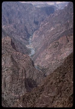
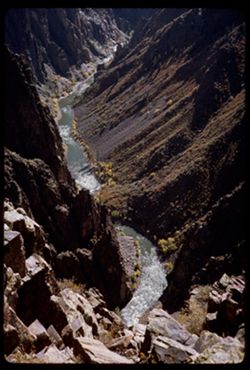
- Description:
- 100 f 13 TL
- Subject:
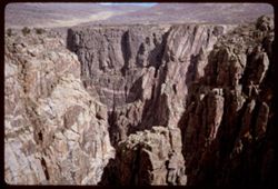
- Black Canyon of the Gunnison National Park (Colo.), Canyons, Cliffs, Mountains, Black Canyon of the Gunnison (Colo.), Rock formations, National parks & r...
- Series:
- 35-65
- Creator:
- Cushman, Charles W., 1896-1972
- Date Created:
- 1965-10-05
- Genre:
- Landscape photographs
- Frame Number:
- 30
- County:
- Montrose
- Abstract:
- Downstream from Sunset View
- Call Number:
- P15060
- Country:
- United States
- State/Province:
- Colorado
- Alternate Identifier:
- 3565.30
- Persistent URL:
- http://purl.dlib.indiana.edu/iudl/archives/cushman/P15060
- Holding Location:
- Bloomington - University Archives
Wells Library E460
1320 E 10th St.
Bloomington, IN 47405
Contact at archives@indiana.edu, 812-855-1127
-
- Description:
- 100 f 13
- Subject:
- Black Canyon of the Gunnison National Park (Colo.), Canyons, Cliffs, Mountains, Black Canyon of the Gunnison (Colo.), Rock formations, National parks & r...
- Series:
- 35-65
- Creator:
- Cushman, Charles W., 1896-1972
- Date Created:
- 1965-10-05
- Genre:
- Landscape photographs
- Frame Number:
- 28
- County:
- Montrose
- Abstract:
- Downstream from Sunset View.
- Call Number:
- P15058
- Country:
- United States
- State/Province:
- Colorado
- Alternate Identifier:
- 3565.28
- Persistent URL:
- http://purl.dlib.indiana.edu/iudl/archives/cushman/P15058
- Holding Location:
- Bloomington - University Archives
Wells Library E460
1320 E 10th St.
Bloomington, IN 47405
Contact at archives@indiana.edu, 812-855-1127
-
- Description:
- 100 f 11 TL
- Subject:
- Canyons, Cliffs, Black Canyon of the Gunnison National Park (Colo.), Mountains, National parks & reserves, Black Canyon of the Gunnison (Colo.), Rivers, ...
- Series:
- 35-65
- Creator:
- Cushman, Charles W., 1896-1972
- Date Created:
- 1965-10-05
- Genre:
- Landscape photographs
- Frame Number:
- 29
- County:
- Montrose
- Abstract:
- Downstream from Sunset View
- Call Number:
- P15059
- Country:
- United States
- State/Province:
- Colorado
- Alternate Identifier:
- 3565.29
- Persistent URL:
- http://purl.dlib.indiana.edu/iudl/archives/cushman/P15059
- Holding Location:
- Bloomington - University Archives
Wells Library E460
1320 E 10th St.
Bloomington, IN 47405
Contact at archives@indiana.edu, 812-855-1127
-
- Description:
- 100 f 11
- Subject:
- Canyons, Cliffs, Black Canyon of the Gunnison National Park (Colo.), Mountains, Rock formations, Black Canyon of the Gunnison (Colo.), Rivers, and National p...
- Series:
- 35-65
- Creator:
- Cushman, Charles W., 1896-1972
- Date Created:
- 1965-10-05
- Genre:
- Landscape photographs
- Frame Number:
- 27
- County:
- Montrose
- Abstract:
- Downstream from Sunset View.
- Call Number:
- P15057
- Country:
- United States
- State/Province:
- Colorado
- Alternate Identifier:
- 3565.27
- Persistent URL:
- http://purl.dlib.indiana.edu/iudl/archives/cushman/P15057
- Holding Location:
- Bloomington - University Archives
Wells Library E460
1320 E 10th St.
Bloomington, IN 47405
Contact at archives@indiana.edu, 812-855-1127
-
- Description:
- 100 f 9
- Subject:
- Rocks, Canyons, Cliffs, Black Canyon of the Gunnison National Park (Colo.), Rock formations, Black Canyon of the Gunnison (Colo.), Rivers, and National parks...
- Series:
- 35-65
- Creator:
- Cushman, Charles W., 1896-1972
- Date Created:
- 1965-10-05
- Genre:
- Landscape photographs
- Frame Number:
- 26
- County:
- Montrose
- Abstract:
- Down into Chasm.
- Call Number:
- P15056
- Country:
- United States
- State/Province:
- Colorado
- Alternate Identifier:
- 3565.26
- Persistent URL:
- http://purl.dlib.indiana.edu/iudl/archives/cushman/P15056
- Holding Location:
- Bloomington - University Archives
Wells Library E460
1320 E 10th St.
Bloomington, IN 47405
Contact at archives@indiana.edu, 812-855-1127
-
- Description:
- 100 f 11
- Subject:
- National parks & reserves, Canyons, Cliffs, Black Canyon of the Gunnison (Colo.), Rock formations, and Black Canyon of the Gunnison National Park (Colo.)
- Series:
- 35-65
- Creator:
- Cushman, Charles W., 1896-1972
- Date Created:
- 1965-10-05
- Genre:
- Landscape photographs
- Frame Number:
- 25
- County:
- Montrose
- Abstract:
- From Chasm view.
- Call Number:
- P15055
- Country:
- United States
- State/Province:
- Colorado
- Alternate Identifier:
- 3565.25
- Persistent URL:
- http://purl.dlib.indiana.edu/iudl/archives/cushman/P15055
- Holding Location:
- Bloomington - University Archives
Wells Library E460
1320 E 10th St.
Bloomington, IN 47405
Contact at archives@indiana.edu, 812-855-1127
-
- Description:
- 100 f 11
- Subject:
- Walls, Canyons, Cliffs, Black Canyon of the Gunnison National Park (Colo.), Rock formations, Black Canyon of the Gunnison (Colo.), and National parks & r...
- Series:
- 35-65
- Creator:
- Cushman, Charles W., 1896-1972
- Date Created:
- 1965-10-05
- Genre:
- Landscape photographs
- Frame Number:
- 24
- County:
- Montrose
- Abstract:
- From Chasm view.
- Call Number:
- P15054
- Country:
- United States
- State/Province:
- Colorado
- Alternate Identifier:
- 3565.24
- Persistent URL:
- http://purl.dlib.indiana.edu/iudl/archives/cushman/P15054
- Holding Location:
- Bloomington - University Archives
Wells Library E460
1320 E 10th St.
Bloomington, IN 47405
Contact at archives@indiana.edu, 812-855-1127
-
- Description:
- 100 f 13
- Subject:
- Canyons, Cliffs, Black Canyon of the Gunnison National Park (Colo.), National parks & reserves, Black Canyon of the Gunnison (Colo.), and Rock formations
- Series:
- 35-65
- Creator:
- Cushman, Charles W., 1896-1972
- Date Created:
- 1965-10-05
- Genre:
- Landscape photographs
- Frame Number:
- 23
- County:
- Montrose
- Abstract:
- From cross canyon overlk.
- Call Number:
- P15053
- Country:
- United States
- State/Province:
- Colorado
- Alternate Identifier:
- 3565.23
- Persistent URL:
- http://purl.dlib.indiana.edu/iudl/archives/cushman/P15053
- Holding Location:
- Bloomington - University Archives
Wells Library E460
1320 E 10th St.
Bloomington, IN 47405
Contact at archives@indiana.edu, 812-855-1127
-
- Description:
- 100 f 13
- Subject:
- Black Canyon of the Gunnison National Park (Colo.), Canyons, Cliffs, Black Canyon of the Gunnison (Colo.), Rock formations, and National parks & reserves
- Series:
- 35-65
- Creator:
- Cushman, Charles W., 1896-1972
- Date Created:
- 1965-10-05
- Genre:
- Landscape photographs
- Frame Number:
- 21
- County:
- Montrose
- Abstract:
- From cross canyon overlk.
- Call Number:
- P15051
- Country:
- United States
- State/Province:
- Colorado
- Alternate Identifier:
- 3565.21
- Persistent URL:
- http://purl.dlib.indiana.edu/iudl/archives/cushman/P15051
- Holding Location:
- Bloomington - University Archives
Wells Library E460
1320 E 10th St.
Bloomington, IN 47405
Contact at archives@indiana.edu, 812-855-1127
-
- Description:
- 100 f 11
- Subject:
- National parks & reserves, Canyons, Cliffs, Mountains, Black Canyon of the Gunnison (Colo.), Rock formations, and Black Canyon of the Gunnison National P...
- Series:
- 35-65
- Creator:
- Cushman, Charles W., 1896-1972
- Date Created:
- 1965-10-05
- Genre:
- Landscape photographs
- Frame Number:
- 22
- County:
- Montrose
- Abstract:
- From cross canyon overlk.
- Call Number:
- P15052
- Country:
- United States
- State/Province:
- Colorado
- Alternate Identifier:
- 3565.22
- Persistent URL:
- http://purl.dlib.indiana.edu/iudl/archives/cushman/P15052
- Holding Location:
- Bloomington - University Archives
Wells Library E460
1320 E 10th St.
Bloomington, IN 47405
Contact at archives@indiana.edu, 812-855-1127
-
- Description:
- 100 f 13
- Subject:
- National parks & reserves, Canyons, Cliffs, Black Canyon of the Gunnison (Colo.), Rock formations, and Black Canyon of the Gunnison National Park (Colo.)
- Series:
- 35-65
- Creator:
- Cushman, Charles W., 1896-1972
- Date Created:
- 1965-10-05
- Genre:
- Landscape photographs
- Frame Number:
- 20
- County:
- Montrose
- Abstract:
- From cross canyon overlk.
- Call Number:
- P15050
- Country:
- United States
- State/Province:
- Colorado
- Alternate Identifier:
- 3565.20
- Persistent URL:
- http://purl.dlib.indiana.edu/iudl/archives/cushman/P15050
- Holding Location:
- Bloomington - University Archives
Wells Library E460
1320 E 10th St.
Bloomington, IN 47405
Contact at archives@indiana.edu, 812-855-1127
-
- Description:
- 200 f 11
- Subject:
- National parks & reserves, Canyons, Cliffs, Black Canyon of the Gunnison (Colo.), Rock formations, and Black Canyon of the Gunnison National Park (Colo.)
- Series:
- 35-65
- Creator:
- Cushman, Charles W., 1896-1972
- Date Created:
- 1965-10-05
- Genre:
- Landscape photographs
- Frame Number:
- 19
- County:
- Montrose
- Abstract:
- From cross canyon overlk.
- Call Number:
- P15049
- Country:
- United States
- State/Province:
- Colorado
- Alternate Identifier:
- 3565.19
- Persistent URL:
- http://purl.dlib.indiana.edu/iudl/archives/cushman/P15049
- Holding Location:
- Bloomington - University Archives
Wells Library E460
1320 E 10th St.
Bloomington, IN 47405
Contact at archives@indiana.edu, 812-855-1127
-
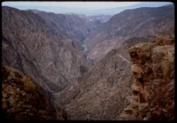
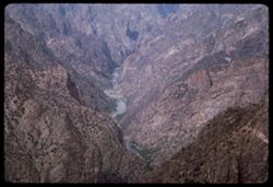
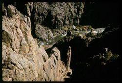
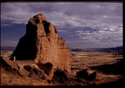
- Description:
- 100 f 9
- Subject:
- Black Canyon of the Gunnison National Park (Colo.), Pulpit Rock (Colo.), Canyons, Cliffs, Mountains, Black Canyon of the Gunnison (Colo.), Rivers, National p...
- Series:
- 35-65
- Creator:
- Cushman, Charles W., 1896-1972
- Date Created:
- 1965-10-05
- Genre:
- Landscape photographs
- Frame Number:
- 17
- County:
- Montrose
- Abstract:
- From Pulpit Rock Overlook.
- Call Number:
- P15047
- Country:
- United States
- State/Province:
- Colorado
- Alternate Identifier:
- 3565.17
- Persistent URL:
- http://purl.dlib.indiana.edu/iudl/archives/cushman/P15047
- Holding Location:
- Bloomington - University Archives
Wells Library E460
1320 E 10th St.
Bloomington, IN 47405
Contact at archives@indiana.edu, 812-855-1127
-
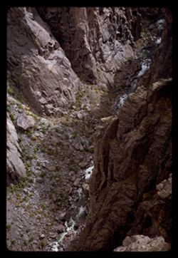
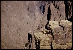
- Description:
- 100 f 11
- Subject:
- Black Canyon of the Gunnison National Park (Colo.), Canyons, Cliffs, Black Canyon of the Gunnison (Colo.), Rivers, National parks & reserves, and Rock fo...
- Series:
- 35-65
- Creator:
- Cushman, Charles W., 1896-1972
- Date Created:
- 1965-10-05
- Genre:
- Landscape photographs
- Frame Number:
- 15
- County:
- Montrose
- Abstract:
- Straight down.
- Call Number:
- P15045
- Country:
- United States
- State/Province:
- Colorado
- Alternate Identifier:
- 3565.15
- Persistent URL:
- http://purl.dlib.indiana.edu/iudl/archives/cushman/P15045
- Holding Location:
- Bloomington - University Archives
Wells Library E460
1320 E 10th St.
Bloomington, IN 47405
Contact at archives@indiana.edu, 812-855-1127
-
- Description:
- 100 f 11
- Subject:
- Canyons, Cliffs, Black Canyon of the Gunnison National Park (Colo.), Pulpit Rock (Colo.), Mountains, National parks & reserves, Rapids, Black Canyon of t...
- Series:
- 35-65
- Creator:
- Cushman, Charles W., 1896-1972
- Date Created:
- 1965-10-05
- Genre:
- Landscape photographs
- Frame Number:
- 16
- County:
- Montrose
- Abstract:
- From Pulpit Rock Overlook.
- Call Number:
- P15046
- Country:
- United States
- State/Province:
- Colorado
- Alternate Identifier:
- 3565.16
- Persistent URL:
- http://purl.dlib.indiana.edu/iudl/archives/cushman/P15046
- Holding Location:
- Bloomington - University Archives
Wells Library E460
1320 E 10th St.
Bloomington, IN 47405
Contact at archives@indiana.edu, 812-855-1127
-
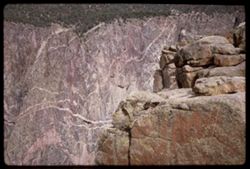
- Description:
- 100 f 16
- Subject:
- Cliffs, Black Canyon of the Gunnison National Park (Colo.), Pulpit Rock (Colo.), Rock formations, Black Canyon of the Gunnison (Colo.), and National parks &a...
- Series:
- 35-65
- Creator:
- Cushman, Charles W., 1896-1972
- Date Created:
- 1965-10-05
- Genre:
- Landscape photographs
- Frame Number:
- 18
- County:
- Montrose
- Abstract:
- From cross canyon overlk.
- Call Number:
- P15048
- Country:
- United States
- State/Province:
- Colorado
- Alternate Identifier:
- 3565.18
- Persistent URL:
- http://purl.dlib.indiana.edu/iudl/archives/cushman/P15048
- Holding Location:
- Bloomington - University Archives
Wells Library E460
1320 E 10th St.
Bloomington, IN 47405
Contact at archives@indiana.edu, 812-855-1127
-
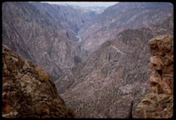
- Description:
- 100 f 11
- Subject:
- Black Canyon of the Gunnison National Park (Colo.), Canyons, Cliffs, Trees, Black Canyon of the Gunnison (Colo.), Rock formations, National parks & reser...
- Series:
- 35-65
- Creator:
- Cushman, Charles W., 1896-1972
- Date Created:
- 1965-10-05
- Genre:
- Landscape photographs
- Frame Number:
- 14
- County:
- Montrose
- Abstract:
- Straight down.
- Call Number:
- P15044
- Country:
- United States
- State/Province:
- Colorado
- Alternate Identifier:
- 3565.14
- Persistent URL:
- http://purl.dlib.indiana.edu/iudl/archives/cushman/P15044
- Holding Location:
- Bloomington - University Archives
Wells Library E460
1320 E 10th St.
Bloomington, IN 47405
Contact at archives@indiana.edu, 812-855-1127
-
- Description:
- 100 f 13
- Subject:
- Canyons, Cliffs, Black Canyon of the Gunnison National Park (Colo.), National parks & reserves, Black Canyon of the Gunnison (Colo.), Rivers, and Rock fo...
- Series:
- 35-65
- Creator:
- Cushman, Charles W., 1896-1972
- Date Created:
- 1965-10-05
- Genre:
- Landscape photographs
- Frame Number:
- 12
- County:
- Montrose
- Abstract:
- Black Canyon of the Gunnison.
- Call Number:
- P15042
- Country:
- United States
- State/Province:
- Colorado
- Alternate Identifier:
- 3565.12
- Persistent URL:
- http://purl.dlib.indiana.edu/iudl/archives/cushman/P15042
- Holding Location:
- Bloomington - University Archives
Wells Library E460
1320 E 10th St.
Bloomington, IN 47405
Contact at archives@indiana.edu, 812-855-1127
-
- Description:
- 200 f 11
- Subject:
- Canyons, Cliffs, Black Canyon of the Gunnison National Park (Colo.), Trees, National parks & reserves, Black Canyon of the Gunnison (Colo.), Rivers, and ...
- Series:
- 35-65
- Creator:
- Cushman, Charles W., 1896-1972
- Date Created:
- 1965-10-05
- Genre:
- Landscape photographs
- Frame Number:
- 13
- County:
- Montrose
- Abstract:
- Down + down stream.
- Call Number:
- P15043
- Country:
- United States
- State/Province:
- Colorado
- Alternate Identifier:
- 3565.13
- Persistent URL:
- http://purl.dlib.indiana.edu/iudl/archives/cushman/P15043
- Holding Location:
- Bloomington - University Archives
Wells Library E460
1320 E 10th St.
Bloomington, IN 47405
Contact at archives@indiana.edu, 812-855-1127
-
- Description:
- 100 f 13
- Subject:
- Canyons, Cliffs, Black Canyon of the Gunnison National Park (Colo.), National parks & reserves, Black Canyon of the Gunnison (Colo.), Rivers, and Rock fo...
- Series:
- 35-65
- Creator:
- Cushman, Charles W., 1896-1972
- Date Created:
- 1965-10-05
- Genre:
- Landscape photographs
- Frame Number:
- 11
- County:
- Montrose
- Abstract:
- Black Canyon of the Gunnison.
- Call Number:
- P15041
- Country:
- United States
- State/Province:
- Colorado
- Alternate Identifier:
- 3565.11
- Persistent URL:
- http://purl.dlib.indiana.edu/iudl/archives/cushman/P15041
- Holding Location:
- Bloomington - University Archives
Wells Library E460
1320 E 10th St.
Bloomington, IN 47405
Contact at archives@indiana.edu, 812-855-1127
-
- Description:
- 100 f 11
- Subject:
- Canyons, Cliffs, Black Canyon of the Gunnison National Park (Colo.), Trees, Mountains, National parks & reserves, Black Canyon of the Gunnison (Colo.), R...
- Series:
- 35-65
- Creator:
- Cushman, Charles W., 1896-1972
- Date Created:
- 1965-10-05
- Genre:
- Landscape photographs
- Frame Number:
- 9
- County:
- Montrose
- Abstract:
- Black Canyon of the Gunnison.
- Call Number:
- P15039
- Country:
- United States
- State/Province:
- Colorado
- Alternate Identifier:
- 3565.9
- Persistent URL:
- http://purl.dlib.indiana.edu/iudl/archives/cushman/P15039
- Holding Location:
- Bloomington - University Archives
Wells Library E460
1320 E 10th St.
Bloomington, IN 47405
Contact at archives@indiana.edu, 812-855-1127
-
- Description:
- 100 f 11
- Subject:
- Canyons, Cliffs, Black Canyon of the Gunnison National Park (Colo.), Rock formations, Black Canyon of the Gunnison (Colo.), and National parks & reserves
- Series:
- 35-65
- Creator:
- Cushman, Charles W., 1896-1972
- Date Created:
- 1965-10-05
- Genre:
- Landscape photographs
- Frame Number:
- 10
- County:
- Montrose
- Abstract:
- Black Canyon of the Gunnison.
- Call Number:
- P15040
- Country:
- United States
- State/Province:
- Colorado
- Alternate Identifier:
- 3565.10
- Persistent URL:
- http://purl.dlib.indiana.edu/iudl/archives/cushman/P15040
- Holding Location:
- Bloomington - University Archives
Wells Library E460
1320 E 10th St.
Bloomington, IN 47405
Contact at archives@indiana.edu, 812-855-1127
-
- Description:
- 100 f 13
- Subject:
- Canyons, Cliffs, Black Canyon of the Gunnison National Park (Colo.), Trees, Rock formations, Black Canyon of the Gunnison (Colo.), Rivers, and National parks...
- Series:
- 35-65
- Creator:
- Cushman, Charles W., 1896-1972
- Date Created:
- 1965-10-05
- Genre:
- Landscape photographs
- Frame Number:
- 8
- County:
- Montrose
- Abstract:
- Black Canyon of the Gunnison.
- Call Number:
- P15038
- Country:
- United States
- State/Province:
- Colorado
- Alternate Identifier:
- 3565.8
- Persistent URL:
- http://purl.dlib.indiana.edu/iudl/archives/cushman/P15038
- Holding Location:
- Bloomington - University Archives
Wells Library E460
1320 E 10th St.
Bloomington, IN 47405
Contact at archives@indiana.edu, 812-855-1127
-
- Description:
- 200 f 11
- Subject:
- Canyons, Cliffs, Black Canyon of the Gunnison National Park (Colo.), Trees, Mountains, Rock formations, Black Canyon of the Gunnison (Colo.), and Rivers
- Series:
- 35-65
- Creator:
- Cushman, Charles W., 1896-1972
- Date Created:
- 1965-10-05
- Genre:
- Landscape photographs
- Frame Number:
- 7
- County:
- Montrose
- Abstract:
- Black Canyon of the Gunnison.
- Call Number:
- P15037
- Country:
- United States
- State/Province:
- Colorado
- Alternate Identifier:
- 3565.7
- Persistent URL:
- http://purl.dlib.indiana.edu/iudl/archives/cushman/P15037
- Holding Location:
- Bloomington - University Archives
Wells Library E460
1320 E 10th St.
Bloomington, IN 47405
Contact at archives@indiana.edu, 812-855-1127
-
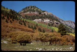
- Description:
- 100 f 13 sl
- Subject:
- Trees, Mountains, Rock formations, and Shrubs
- Series:
- 34-65
- Creator:
- Cushman, Charles W., 1896-1972
- Date Created:
- 1965-10-03
- Genre:
- Landscape photographs
- Frame Number:
- 15
- County:
- La Plata
- Abstract:
- 2 truncated pyramids w. of Durango
- Call Number:
- P15007
- City:
- Durango
- Country:
- United States
- State/Province:
- Colorado
- Alternate Identifier:
- 3465.15
- Persistent URL:
- http://purl.dlib.indiana.edu/iudl/archives/cushman/P15007
- Holding Location:
- Bloomington - University Archives
Wells Library E460
1320 E 10th St.
Bloomington, IN 47405
Contact at archives@indiana.edu, 812-855-1127
-
- Description:
- 100 f 13 sl
- Subject:
- Grasses, Trees, Mountains, Fences, Shrubs, and Rock formations
- Series:
- 34-65
- Creator:
- Cushman, Charles W., 1896-1972
- Date Created:
- 1965-10-03
- Genre:
- Landscape photographs
- Frame Number:
- 14
- County:
- La Plata
- Abstract:
- 2 truncated pyramids w. of Durango
- Call Number:
- P15006
- City:
- Durango
- Country:
- United States
- State/Province:
- Colorado
- Alternate Identifier:
- 3465.14
- Persistent URL:
- http://purl.dlib.indiana.edu/iudl/archives/cushman/P15006
- Holding Location:
- Bloomington - University Archives
Wells Library E460
1320 E 10th St.
Bloomington, IN 47405
Contact at archives@indiana.edu, 812-855-1127
-
- Description:
- 100 f 13
- Subject:
- Houses, Trees, Roofs, Mountains, Rock formations, Dormers, and Cliffs
- Series:
- 33-65
- Creator:
- Cushman, Charles W., 1896-1972
- Date Created:
- 1965-10-02
- Genre:
- Landscape photographs
- Frame Number:
- 31
- Street Address:
- Molas Pass
- County:
- San Juan and La Plata
- Abstract:
- Looking up
- Call Number:
- P14986
- City:
- Durango
- Country:
- United States
- State/Province:
- Colorado
- Alternate Identifier:
- 3365.31
- Persistent URL:
- http://purl.dlib.indiana.edu/iudl/archives/cushman/P14986
- Holding Location:
- Bloomington - University Archives
Wells Library E460
1320 E 10th St.
Bloomington, IN 47405
Contact at archives@indiana.edu, 812-855-1127
-
- Description:
- 100 f 11 sl
- Subject:
- Cliffs, Trees, Tree limbs, Mountains, Rock formations, and Forests
- Series:
- 33-65
- Creator:
- Cushman, Charles W., 1896-1972
- Date Created:
- 1965-10-02
- Genre:
- Landscape photographs
- Frame Number:
- 28
- Street Address:
- United States Highway 550
- County:
- La Plata and Ouray
- Abstract:
- Pink [mountain]
- Call Number:
- P14983
- City:
- Durango and Ouray
- Country:
- United States
- State/Province:
- Colorado
- Alternate Identifier:
- 3365.28
- Persistent URL:
- http://purl.dlib.indiana.edu/iudl/archives/cushman/P14983
- Holding Location:
- Bloomington - University Archives
Wells Library E460
1320 E 10th St.
Bloomington, IN 47405
Contact at archives@indiana.edu, 812-855-1127
-
- Description:
- 100 f 11 sl
- Subject:
- Rocks, Valleys, Cliffs, Trees, Mountains, Fences, Rock formations, and Forests
- Series:
- 32-65
- Creator:
- Cushman, Charles W., 1896-1972
- Date Created:
- 1965-10-02
- Genre:
- Landscape photographs
- Frame Number:
- 37
- Street Address:
- United States Highway 550
- County:
- San Juan and La Plata
- Abstract:
- Maybe [Hernora] cliffs
- Call Number:
- P14955
- City:
- Durango and Silverton
- Country:
- United States
- State/Province:
- Colorado
- Alternate Identifier:
- 3265.37
- Persistent URL:
- http://purl.dlib.indiana.edu/iudl/archives/cushman/P14955
- Holding Location:
- Bloomington - University Archives
Wells Library E460
1320 E 10th St.
Bloomington, IN 47405
Contact at archives@indiana.edu, 812-855-1127
-
- Description:
- 100 f 11 sl
- Subject:
- Valleys, Cliffs, Trees, Mountains, Rock formations, and Forests
- Series:
- 32-65
- Creator:
- Cushman, Charles W., 1896-1972
- Date Created:
- 1965-10-02
- Genre:
- Landscape photographs
- Frame Number:
- 36
- Street Address:
- United States Highway 550
- County:
- San Juan and La Plata
- Abstract:
- Cliffs and fall colors
- Call Number:
- P14954
- City:
- Durango and Silverton
- Country:
- United States
- State/Province:
- Colorado
- Alternate Identifier:
- 3265.36
- Persistent URL:
- http://purl.dlib.indiana.edu/iudl/archives/cushman/P14954
- Holding Location:
- Bloomington - University Archives
Wells Library E460
1320 E 10th St.
Bloomington, IN 47405
Contact at archives@indiana.edu, 812-855-1127
-
- Description:
- 100 f 11 sl
- Subject:
- Forests, Mountains, Trees, and Rock formations
- Series:
- 32-65
- Creator:
- Cushman, Charles W., 1896-1972
- Date Created:
- 1965-10-02
- Genre:
- Landscape photographs
- Frame Number:
- 35
- Street Address:
- United States Highway 550
- County:
- La Plata and San Juan
- Abstract:
- Cliffs and fall colors
- Call Number:
- P14953
- City:
- Silverton and Durango
- Country:
- United States
- State/Province:
- Colorado
- Alternate Identifier:
- 3265.35
- Persistent URL:
- http://purl.dlib.indiana.edu/iudl/archives/cushman/P14953
- Holding Location:
- Bloomington - University Archives
Wells Library E460
1320 E 10th St.
Bloomington, IN 47405
Contact at archives@indiana.edu, 812-855-1127
-

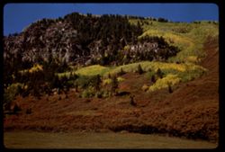
- Description:
- 100 f 11 sl
- Subject:
- Cliffs, Trees, Mountains, Rock formations, and Forests
- Series:
- 32-65
- Creator:
- Cushman, Charles W., 1896-1972
- Date Created:
- 1965-10-02
- Genre:
- Landscape photographs
- Frame Number:
- 34
- Street Address:
- United States Highway 550
- County:
- San Juan and La Plata
- Abstract:
- Cliffs and fall colors
- Call Number:
- P14952
- City:
- Durango and Silverton
- Country:
- United States
- State/Province:
- Colorado
- Alternate Identifier:
- 3265.34
- Persistent URL:
- http://purl.dlib.indiana.edu/iudl/archives/cushman/P14952
- Holding Location:
- Bloomington - University Archives
Wells Library E460
1320 E 10th St.
Bloomington, IN 47405
Contact at archives@indiana.edu, 812-855-1127
-
- Description:
- 100 f 16 sl
- Subject:
- Cliffs, Trees, Mountains, Rock formations, Firs, Animas River (Colo. and N.M.), and Forests
- Series:
- 32-65
- Creator:
- Cushman, Charles W., 1896-1972
- Date Created:
- 1965-10-02
- Genre:
- Landscape photographs
- Frame Number:
- 32
- Street Address:
- United States Highway 550
- County:
- La Plata
- Abstract:
- Cliffs and fall colors
- Call Number:
- P14950
- City:
- Durango
- Country:
- United States
- State/Province:
- Colorado
- Alternate Identifier:
- 3265.32
- Persistent URL:
- http://purl.dlib.indiana.edu/iudl/archives/cushman/P14950
- Holding Location:
- Bloomington - University Archives
Wells Library E460
1320 E 10th St.
Bloomington, IN 47405
Contact at archives@indiana.edu, 812-855-1127
-
- Description:
- 100 f 16 tl
- Subject:
- Canyons, Cliffs, Trees, Mountains, Rock formations, Forests, and Firs
- Series:
- 32-65
- Creator:
- Cushman, Charles W., 1896-1972
- Date Created:
- 1965-10-02
- Genre:
- Landscape photographs
- Frame Number:
- 31
- Street Address:
- United States Highway 550
- County:
- San Juan and La Plata
- Abstract:
- Cliffs and fall colors
- Call Number:
- P14949
- City:
- Durango and Silverton
- Country:
- United States
- State/Province:
- Colorado
- Alternate Identifier:
- 3265.31
- Persistent URL:
- http://purl.dlib.indiana.edu/iudl/archives/cushman/P14949
- Holding Location:
- Bloomington - University Archives
Wells Library E460
1320 E 10th St.
Bloomington, IN 47405
Contact at archives@indiana.edu, 812-855-1127
-
- Description:
- 100 f 13 tl
- Subject:
- Firs, Forests, Cliffs, Mountains, Trees, and Rock formations
- Series:
- 32-65
- Creator:
- Cushman, Charles W., 1896-1972
- Date Created:
- 1965-10-02
- Genre:
- Landscape photographs
- Frame Number:
- 29
- Street Address:
- United States Highway 550
- County:
- La Plata and San Juan
- Abstract:
- Cliffs & fall colors
- Call Number:
- P14947
- City:
- Silverton and Durango
- Country:
- United States
- State/Province:
- Colorado
- Alternate Identifier:
- 3265.29
- Persistent URL:
- http://purl.dlib.indiana.edu/iudl/archives/cushman/P14947
- Holding Location:
- Bloomington - University Archives
Wells Library E460
1320 E 10th St.
Bloomington, IN 47405
Contact at archives@indiana.edu, 812-855-1127
-
- Description:
- 100 f 13 tl
- Subject:
- Forests, Cliffs, Mountains, Trees, and Rock formations
- Series:
- 32-65
- Creator:
- Cushman, Charles W., 1896-1972
- Date Created:
- 1965-10-02
- Genre:
- Landscape photographs
- Frame Number:
- 27
- Street Address:
- United States Highway 550
- County:
- La Plata
- Abstract:
- Waterfall nearby
- Call Number:
- P14945
- City:
- Durango
- Country:
- United States
- State/Province:
- Colorado
- Alternate Identifier:
- 3265.27
- Persistent URL:
- http://purl.dlib.indiana.edu/iudl/archives/cushman/P14945
- Holding Location:
- Bloomington - University Archives
Wells Library E460
1320 E 10th St.
Bloomington, IN 47405
Contact at archives@indiana.edu, 812-855-1127
-
- Description:
- 100 f 13 tl
- Subject:
- Grasses, Houses, Waterfalls, Trees, Meadows, Mountains, Fences, Rock formations, Trucks, and Cliffs
- Series:
- 32-65
- Creator:
- Cushman, Charles W., 1896-1972
- Date Created:
- 1965-10-02
- Genre:
- Landscape photographs
- Frame Number:
- 26
- Street Address:
- United States Highway 550
- County:
- La Plata
- Abstract:
- Waterfall nearby
- Call Number:
- P14944
- City:
- Durango
- Country:
- United States
- State/Province:
- Colorado
- Alternate Identifier:
- 3265.26
- Persistent URL:
- http://purl.dlib.indiana.edu/iudl/archives/cushman/P14944
- Holding Location:
- Bloomington - University Archives
Wells Library E460
1320 E 10th St.
Bloomington, IN 47405
Contact at archives@indiana.edu, 812-855-1127
-
- Description:
- 100 f 13
- Subject:
- Grasses, Cliffs, Trees, Meadows, Mountains, Rock formations, and Houses
- Series:
- 32-65
- Creator:
- Cushman, Charles W., 1896-1972
- Date Created:
- 1965-10-02
- Genre:
- Landscape photographs
- Frame Number:
- 25
- Street Address:
- United States Highway 550
- County:
- La Plata
- Abstract:
- Horses below mtn side
- Call Number:
- P14943
- City:
- Durango
- Country:
- United States
- State/Province:
- Colorado
- Alternate Identifier:
- 3265.25
- Persistent URL:
- http://purl.dlib.indiana.edu/iudl/archives/cushman/P14943
- Holding Location:
- Bloomington - University Archives
Wells Library E460
1320 E 10th St.
Bloomington, IN 47405
Contact at archives@indiana.edu, 812-855-1127
-
- Description:
- 100 f 11
- Subject:
- Electric lines, Houses, Mountains, Rock formations, Utility poles, and Croplands
- Series:
- 32-65
- Creator:
- Cushman, Charles W., 1896-1972
- Date Created:
- 1965-10-02
- Genre:
- Landscape photographs
- Frame Number:
- 21
- Street Address:
- United States Highway 550
- County:
- La Plata
- Abstract:
- few miles north of Durango
- Call Number:
- P14939
- City:
- Durango
- Country:
- United States
- State/Province:
- Colorado
- Alternate Identifier:
- 3265.21
- Persistent URL:
- http://purl.dlib.indiana.edu/iudl/archives/cushman/P14939
- Holding Location:
- Bloomington - University Archives
Wells Library E460
1320 E 10th St.
Bloomington, IN 47405
Contact at archives@indiana.edu, 812-855-1127
-
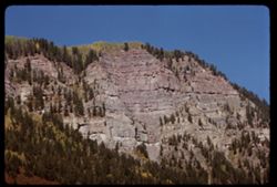
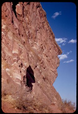
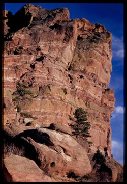
- Description:
- 50 f 8
- Subject:
- Canyons, Grasses, Cliffs, Trees, Red Canyon (Garfield County, Colo.), Tree limbs, Mountains, Rock formations, Clouds, and Hills
- Series:
- 9-53
- Creator:
- Cushman, Charles W., 1896-1972
- Date Created:
- 1953-10-13
- Genre:
- Landscape photographs
- Frame Number:
- 38
- County:
- Garfield
- Abstract:
- Red Canyon, south of Glenwood Spgs.
- Call Number:
- P06839
- City:
- Glenwood Springs
- Country:
- United States
- State/Province:
- Colorado
- Alternate Identifier:
- 953.38
- Persistent URL:
- http://purl.dlib.indiana.edu/iudl/archives/cushman/P06839
- Holding Location:
- Bloomington - University Archives
Wells Library E460
1320 E 10th St.
Bloomington, IN 47405
Contact at archives@indiana.edu, 812-855-1127
-
- Description:
- 50 f 7 Pola
- Subject:
- Pyramidal mountain, Grasses, Trees, Mountains, Rock formations, Clouds, Rivers, Erosion, Mesas, and Formations (Geology)
- Series:
- 9-53
- Creator:
- Cushman, Charles W., 1896-1972
- Date Created:
- 1953-10-12
- Genre:
- Landscape photographs
- Frame Number:
- 28
- Street Address:
- United States Highway 6
- County:
- Mesa
- Abstract:
- Pyramid above Co[?] Colorado river.
- Call Number:
- P06829
- City:
- Grand Junction
- Country:
- United States
- State/Province:
- Colorado
- Physical Description:
- Image was originally mounted in a glass enclosure. Before digitization, the image was removed and placed in a Wess Plastic, Inc. brand, 2" x 2", pl...
- Alternate Identifier:
- 953.28
- Persistent URL:
- http://purl.dlib.indiana.edu/iudl/archives/cushman/P06829
- Holding Location:
- Bloomington - University Archives
Wells Library E460
1320 E 10th St.
Bloomington, IN 47405
Contact at archives@indiana.edu, 812-855-1127
-
- Description:
- 25 f 11
- Subject:
- Valleys, Cliffs, Colorado National Monument (Colo.), Grand View Overlook (Colo.), Mesas, Colorado River (Colo.-Mexico), Buttes, Mountains, Rock formations, C...
- Series:
- 26-52
- Creator:
- Cushman, Charles W., 1896-1972
- Date Created:
- 1952-11-03
- Genre:
- Landscape photographs
- Frame Number:
- 19
- County:
- Mesa
- Abstract:
- from Grandview Overlook.
- Call Number:
- P06425
- City:
- Grand Junction
- Country:
- United States
- State/Province:
- Colorado
- Alternate Identifier:
- 2652.19
- Persistent URL:
- http://purl.dlib.indiana.edu/iudl/archives/cushman/P06425
- Holding Location:
- Bloomington - University Archives
Wells Library E460
1320 E 10th St.
Bloomington, IN 47405
Contact at archives@indiana.edu, 812-855-1127
-
- Description:
- 25 f 11
- Subject:
- Valleys, Cliffs, Colorado National Monument (Colo.), Mesas, Buttes, Rock formations, Trees, National parks & reserves, and Shrubs
- Series:
- 26-52
- Creator:
- Cushman, Charles W., 1896-1972
- Date Created:
- 1952-11-03
- Genre:
- Landscape photographs
- Frame Number:
- 18
- Abstract:
- view north.
- Call Number:
- P06424
- Country:
- United States
- State/Province:
- Colorado
- Alternate Identifier:
- 2652.18
- Persistent URL:
- http://purl.dlib.indiana.edu/iudl/archives/cushman/P06424
- Holding Location:
- Bloomington - University Archives
Wells Library E460
1320 E 10th St.
Bloomington, IN 47405
Contact at archives@indiana.edu, 812-855-1127
-
- Description:
- 25 f 11
- Subject:
- Valleys, Bodies of water, Cliffs, Colorado National Monument (Colo.), Mesas, Colorado River (Colo.-Mexico), Shadows, Mountains, Rock formations, Colorado Riv...
- Series:
- 26-52
- Creator:
- Cushman, Charles W., 1896-1972
- Date Created:
- 1952-11-03
- Genre:
- Landscape photographs
- Frame Number:
- 17
- County:
- Mesa
- Abstract:
- view north.
- Call Number:
- P06423
- City:
- Grand Junction
- Country:
- United States
- State/Province:
- Colorado
- Alternate Identifier:
- 2652.17
- Persistent URL:
- http://purl.dlib.indiana.edu/iudl/archives/cushman/P06423
- Holding Location:
- Bloomington - University Archives
Wells Library E460
1320 E 10th St.
Bloomington, IN 47405
Contact at archives@indiana.edu, 812-855-1127
-
- Description:
- 25 f 11
- Subject:
- Tree limbs, Valleys, Colorado National Monument (Colo.), Cliffs, Grand View Overlook (Colo.), Buttes, Scenic overlooks, Mesas, National parks & reserves,...
- Series:
- 26-52
- Creator:
- Cushman, Charles W., 1896-1972
- Date Created:
- 1952-11-03
- Genre:
- Landscape photographs
- Frame Number:
- 16
- Abstract:
- view north.
- Call Number:
- P06422
- Country:
- United States
- State/Province:
- Colorado
- Alternate Identifier:
- 2652.16
- Persistent URL:
- http://purl.dlib.indiana.edu/iudl/archives/cushman/P06422
- Holding Location:
- Bloomington - University Archives
Wells Library E460
1320 E 10th St.
Bloomington, IN 47405
Contact at archives@indiana.edu, 812-855-1127
-
- Description:
- 25 f 6.3 Pola
- Subject:
- Rocks, Canyons, Cliffs, Colorado National Monument (Colo.), Shadows, Buttes, Shrubs, National parks & reserves, and Rock formations
- Series:
- 26-52
- Creator:
- Cushman, Charles W., 1896-1972
- Date Created:
- 1952-11-03
- Genre:
- Landscape photographs
- Frame Number:
- 14
- County:
- Mesa
- Abstract:
- Grand.
- Call Number:
- P06421
- City:
- Grand Junction
- Country:
- United States
- State/Province:
- Colorado
- Alternate Identifier:
- 2652.14
- Persistent URL:
- http://purl.dlib.indiana.edu/iudl/archives/cushman/P06421
- Holding Location:
- Bloomington - University Archives
Wells Library E460
1320 E 10th St.
Bloomington, IN 47405
Contact at archives@indiana.edu, 812-855-1127
-
- Description:
- 25 f 12
- Subject:
- Canyons, Cliffs, Colorado National Monument (Colo.), Mesas, Shadows, Mountains, Rock formations, Roads, National parks & reserves, and Shrubs
- Series:
- 26-52
- Creator:
- Cushman, Charles W., 1896-1972
- Date Created:
- 1952-11-03
- Genre:
- Landscape photographs
- Frame Number:
- 12
- County:
- Mesa
- Abstract:
- Grand shelves.
- Call Number:
- P06419
- City:
- Grand Junction
- Country:
- United States
- State/Province:
- Colorado
- Alternate Identifier:
- 2652.12
- Persistent URL:
- http://purl.dlib.indiana.edu/iudl/archives/cushman/P06419
- Holding Location:
- Bloomington - University Archives
Wells Library E460
1320 E 10th St.
Bloomington, IN 47405
Contact at archives@indiana.edu, 812-855-1127
-
- Description:
- 25 f 11
- Subject:
- Rocks, Cliffs, Colorado National Monument (Colo.), Trees, Boulders, National parks & reserves, and Rock formations
- Series:
- 26-52
- Creator:
- Cushman, Charles W., 1896-1972
- Date Created:
- 1952-11-03
- Genre:
- Landscape photographs
- Frame Number:
- 2
- County:
- Mesa
- Abstract:
- Looking up at odd shapes.
- Call Number:
- P06409
- City:
- Grand Junction
- Country:
- United States
- State/Province:
- Colorado
- Alternate Identifier:
- 2652.2
- Persistent URL:
- http://purl.dlib.indiana.edu/iudl/archives/cushman/P06409
- Holding Location:
- Bloomington - University Archives
Wells Library E460
1320 E 10th St.
Bloomington, IN 47405
Contact at archives@indiana.edu, 812-855-1127
-
- Description:
- 25 f 11
- Subject:
- Rocks, Cliffs, Colorado National Monument (Colo.), Trees, Boulders, National parks & reserves, and Rock formations
- Series:
- 26-52
- Creator:
- Cushman, Charles W., 1896-1972
- Date Created:
- 1952-11-03
- Genre:
- Landscape photographs
- Frame Number:
- 1
- County:
- Mesa
- Abstract:
- Looking up at odd shapes.
- Call Number:
- P06408
- City:
- Grand Junction
- Country:
- United States
- State/Province:
- Colorado
- Alternate Identifier:
- 2652.1
- Persistent URL:
- http://purl.dlib.indiana.edu/iudl/archives/cushman/P06408
- Holding Location:
- Bloomington - University Archives
Wells Library E460
1320 E 10th St.
Bloomington, IN 47405
Contact at archives@indiana.edu, 812-855-1127
-
- Description:
- 25 f 6.3 Pola
- Subject:
- National parks & reserves, Hills, Colorado National Monument (Colo.), Cliffs, Mountains, Boulders, Rocks, Buttes, Rock formations, Junipers, and Trees
- Series:
- 25-52
- Creator:
- Cushman, Charles W., 1896-1972
- Date Created:
- 1952-11-03
- Genre:
- Landscape photographs
- Frame Number:
- 38
- County:
- Mesa
- Abstract:
- Across juniper tops.
- Call Number:
- P06407
- City:
- Grand Junction
- Country:
- United States
- State/Province:
- Colorado
- Alternate Identifier:
- 2552.38
- Persistent URL:
- http://purl.dlib.indiana.edu/iudl/archives/cushman/P06407
- Holding Location:
- Bloomington - University Archives
Wells Library E460
1320 E 10th St.
Bloomington, IN 47405
Contact at archives@indiana.edu, 812-855-1127
-
- Description:
- 50 f 8
- Subject:
- Rocks, Rocky Mountains, Boulders, Rock formations, Passes (Landforms), Rocky Mountain National Park (Colo.), and National parks & reserves
- Series:
- 25-52
- Creator:
- Cushman, Charles W., 1896-1972
- Date Created:
- 1952-11-01
- Genre:
- Snapshots
- Frame Number:
- 4
- Abstract:
- Rocks above pass at 12,110 ft. elev.
- Call Number:
- P06373
- Country:
- United States
- State/Province:
- Colorado
- Alternate Identifier:
- 2552.4
- Persistent URL:
- http://purl.dlib.indiana.edu/iudl/archives/cushman/P06373
- Holding Location:
- Bloomington - University Archives
Wells Library E460
1320 E 10th St.
Bloomington, IN 47405
Contact at archives@indiana.edu, 812-855-1127
-
- Description:
- 50 f 8
- Subject:
- Rocks, Rocky Mountains, Cliffs, Boulders, National parks & reserves, Passes (Landforms), Rocky Mountain National Park (Colo.), and Rock formations
- Series:
- 25-52
- Creator:
- Cushman, Charles W., 1896-1972
- Date Created:
- 1952-11-01
- Genre:
- Snapshots
- Frame Number:
- 3
- Abstract:
- Rocks above pass at 12,110 ft. elev.
- Call Number:
- P06372
- Country:
- United States
- State/Province:
- Colorado
- Alternate Identifier:
- 2552.3
- Persistent URL:
- http://purl.dlib.indiana.edu/iudl/archives/cushman/P06372
- Holding Location:
- Bloomington - University Archives
Wells Library E460
1320 E 10th St.
Bloomington, IN 47405
Contact at archives@indiana.edu, 812-855-1127
-
- Description:
- 25 f 9
- Subject:
- Rocks, Cliffs, Trees, Clear Creek (Clear Creek County, Colo.), Mountains, and Rock formations
- Series:
- 24-52
- Creator:
- Cushman, Charles W., 1896-1972
- Date Created:
- 1952-10-31
- Genre:
- Landscape photographs
- Frame Number:
- 16
- Street Address:
- United States Highway 6
- County:
- Denver
- Abstract:
- Craggy pinnacle above bend of Clear Creek - Hwy US 6.
- Call Number:
- P06347
- City:
- Denver
- Country:
- United States
- State/Province:
- Colorado
- Alternate Identifier:
- 2452.16
- Persistent URL:
- http://purl.dlib.indiana.edu/iudl/archives/cushman/P06347
- Holding Location:
- Bloomington - University Archives
Wells Library E460
1320 E 10th St.
Bloomington, IN 47405
Contact at archives@indiana.edu, 812-855-1127
-
- Description:
- 25 f 11
- Subject:
- Croplands, Red Rocks Park (Jefferson County, Colo.), Rocky Mountains, Houses, Outbuildings, Mountains, Trees, Rock formations, Fences, Red Rocks Amphitheatre...
- Series:
- 24-52
- Creator:
- Cushman, Charles W., 1896-1972
- Date Created:
- 1952-10-31
- Genre:
- Landscape photographs
- Frame Number:
- 15
- Street Address:
- Colorado State Highway 74
- County:
- Jefferson
- Abstract:
- Along Colo 74 - mtn side near Red Rocks theatre.
- Call Number:
- P06346
- City:
- Morrison
- Country:
- United States
- State/Province:
- Colorado
- Physical Description:
- Image was originally mounted in a glass enclosure. Before digitization, the image was removed and placed in a Wess Plastic, Inc. brand, 2" x 2", pl...
- Alternate Identifier:
- 2452.15
- Persistent URL:
- http://purl.dlib.indiana.edu/iudl/archives/cushman/P06346
- Holding Location:
- Bloomington - University Archives
Wells Library E460
1320 E 10th St.
Bloomington, IN 47405
Contact at archives@indiana.edu, 812-855-1127
-
- Description:
- 25 f 8
- Subject:
- Grasses, Cliffs, Parks, Trees, Boulders, Shadows, Buttes, Shrubs, Red Rocks Park (Jefferson County, Colo.), and Rock formations
- Series:
- 24-52
- Creator:
- Cushman, Charles W., 1896-1972
- Date Created:
- 1952-10-30
- Genre:
- Landscape photographs
- Frame Number:
- 12
- County:
- Jefferson
- Abstract:
- Tilted rock on road down
- Call Number:
- P06343
- City:
- Morrison
- Country:
- United States
- State/Province:
- Colorado
- Alternate Identifier:
- 2452.12
- Persistent URL:
- http://purl.dlib.indiana.edu/iudl/archives/cushman/P06343
- Holding Location:
- Bloomington - University Archives
Wells Library E460
1320 E 10th St.
Bloomington, IN 47405
Contact at archives@indiana.edu, 812-855-1127
-
- Description:
- 25 f 4.5 POLA
- Subject:
- Red Rocks Amphitheatre, Rock formations, Rocks, Red Rocks Park (Jefferson County, Colo.), Hills, Mountains, Shadows, Clouds, Amphitheaters, Parks, and Boulders
- Series:
- 24-52
- Creator:
- Cushman, Charles W., 1896-1972
- Date Created:
- 1952-10-30
- Genre:
- Landscape photographs
- Frame Number:
- 11
- County:
- Jefferson and Denver
- Abstract:
- View SE and down from Red Rocks Amphitheatre
- Call Number:
- P06342
- City:
- Morrison and Denver
- Country:
- United States
- State/Province:
- Colorado
- Alternate Identifier:
- 2452.11
- Persistent URL:
- http://purl.dlib.indiana.edu/iudl/archives/cushman/P06342
- Holding Location:
- Bloomington - University Archives
Wells Library E460
1320 E 10th St.
Bloomington, IN 47405
Contact at archives@indiana.edu, 812-855-1127
-

- Description:
- 25 f 8
- Subject:
- Red Rocks Park (Jefferson County, Colo.), Parks, Cliffs, Shadows, Buttes, and Rock formations
- Series:
- 24-52
- Creator:
- Cushman, Charles W., 1896-1972
- Date Created:
- 1952-10-30
- Genre:
- Views
- Frame Number:
- 10
- County:
- Jefferson and Denver
- Abstract:
- 2nd red rock - west face from NW
- Call Number:
- P06341
- City:
- Morrison and Denver
- Country:
- United States
- State/Province:
- Colorado
- Alternate Identifier:
- 2452.10
- Persistent URL:
- http://purl.dlib.indiana.edu/iudl/archives/cushman/P06341
- Holding Location:
- Bloomington - University Archives
Wells Library E460
1320 E 10th St.
Bloomington, IN 47405
Contact at archives@indiana.edu, 812-855-1127
-
- Description:
- 25 f 9
- Subject:
- Red Rocks Park (Jefferson County, Colo.), Parks, Red beds, Cliffs, Shrubs, Shadows, Buttes, and Rock formations
- Series:
- 24-52
- Creator:
- Cushman, Charles W., 1896-1972
- Date Created:
- 1952-10-30
- Genre:
- Views
- Frame Number:
- 9
- County:
- Jefferson
- Abstract:
- Looking up at south face
- Call Number:
- P06340
- City:
- Morrison
- Country:
- United States
- State/Province:
- Colorado
- Alternate Identifier:
- 2452.9
- Persistent URL:
- http://purl.dlib.indiana.edu/iudl/archives/cushman/P06340
- Holding Location:
- Bloomington - University Archives
Wells Library E460
1320 E 10th St.
Bloomington, IN 47405
Contact at archives@indiana.edu, 812-855-1127
-
- Description:
- 25 f 10
- Subject:
- Rocks, Cliffs, Parks, Trees, Boulders, Buttes, Shrubs, Red beds, Rock formations, and Red Rocks Park (Jefferson County, Colo.)
- Series:
- 24-52
- Creator:
- Cushman, Charles W., 1896-1972
- Date Created:
- 1952-10-30
- Genre:
- Landscape photographs
- Frame Number:
- 8
- County:
- Jefferson and Denver
- Abstract:
- Looking up at huge red rock
- Call Number:
- P06339
- City:
- Denver and Morrison
- Country:
- United States
- State/Province:
- Colorado
- Physical Description:
- Image was originally mounted in a glass enclosure. Before digitization, the image was removed and placed in a Wess Plastic, Inc. brand, 2" x 2", pl...
- Alternate Identifier:
- 2452.8
- Persistent URL:
- http://purl.dlib.indiana.edu/iudl/archives/cushman/P06339
- Holding Location:
- Bloomington - University Archives
Wells Library E460
1320 E 10th St.
Bloomington, IN 47405
Contact at archives@indiana.edu, 812-855-1127
-
- Description:
- 25 f 11
- Subject:
- Cliffs, Parks, Shadows, Buttes, Mountains, Fences, Rock formations, Red Rocks Park (Jefferson County, Colo.), Hills, Roads, and Shrubs
- Series:
- 24-52
- Creator:
- Cushman, Charles W., 1896-1972
- Date Created:
- 1952-10-30
- Genre:
- Landscape photographs
- Frame Number:
- 7
- County:
- Jefferson
- Abstract:
- NE from Red Rock Park
- Call Number:
- P06338
- City:
- Morrison
- Country:
- United States
- State/Province:
- Colorado
- Alternate Identifier:
- 2452.7
- Persistent URL:
- http://purl.dlib.indiana.edu/iudl/archives/cushman/P06338
- Holding Location:
- Bloomington - University Archives
Wells Library E460
1320 E 10th St.
Bloomington, IN 47405
Contact at archives@indiana.edu, 812-855-1127
-
- Description:
- 25 f 6 POLA
- Subject:
- Rocks, Cliffs, Parks, Boulders, Buttes, Buildings, Rock formations, Red Rocks Park (Jefferson County, Colo.), and Red beds
- Series:
- 24-52
- Creator:
- Cushman, Charles W., 1896-1972
- Date Created:
- 1952-10-30
- Genre:
- Landscape photographs
- Frame Number:
- 6
- County:
- Jefferson
- Abstract:
- [L] of 3 & 4
- Call Number:
- P06337
- City:
- Morrison
- Country:
- United States
- State/Province:
- Colorado
- Alternate Identifier:
- 2452.6
- Persistent URL:
- http://purl.dlib.indiana.edu/iudl/archives/cushman/P06337
- Holding Location:
- Bloomington - University Archives
Wells Library E460
1320 E 10th St.
Bloomington, IN 47405
Contact at archives@indiana.edu, 812-855-1127
-

- Description:
- 25 f 6 POLA
- Subject:
- Rocks, Roads, Parks, Boulders, Shadows, Buttes, Mountains, Buildings, Rock formations, Clouds, Red Rocks Park (Jefferson County, Colo.), Hills, and Cliffs
- Series:
- 24-52
- Creator:
- Cushman, Charles W., 1896-1972
- Date Created:
- 1952-10-30
- Genre:
- Landscape photographs
- Frame Number:
- 5
- County:
- Jefferson
- Abstract:
- Red Rock Park west of Denver
- Call Number:
- P06336
- City:
- Morrison
- Country:
- United States
- State/Province:
- Colorado
- Alternate Identifier:
- 2452.5
- Persistent URL:
- http://purl.dlib.indiana.edu/iudl/archives/cushman/P06336
- Holding Location:
- Bloomington - University Archives
Wells Library E460
1320 E 10th St.
Bloomington, IN 47405
Contact at archives@indiana.edu, 812-855-1127
-
- Description:
- 25 f 6 Pola
- Subject:
- Red Rocks Park (Jefferson County, Colo.), Automobiles, Red beds, Parking lots, Cliffs, People, Shrubs, Boulders, Buildings, Buttes, Rock formations, Roads, T...
- Series:
- 24-52
- Creator:
- Cushman, Charles W., 1896-1972
- Date Created:
- 1952-10-30
- Genre:
- Landscape photographs
- Frame Number:
- 4
- County:
- Jefferson
- Abstract:
- Great Tall red rock
- Call Number:
- P06335
- City:
- Morrison
- Country:
- United States
- State/Province:
- Colorado
- Alternate Identifier:
- 2452.4
- Persistent URL:
- http://purl.dlib.indiana.edu/iudl/archives/cushman/P06335
- Holding Location:
- Bloomington - University Archives
Wells Library E460
1320 E 10th St.
Bloomington, IN 47405
Contact at archives@indiana.edu, 812-855-1127
-
- Description:
- 25 f 9
- Subject:
- Rocks, Roads, Parks, Trees, Boulders, Buttes, Shrubs, Red Rocks Park (Jefferson County, Colo.), People, Cliffs, Rock formations, and Red beds
- Series:
- 24-52
- Creator:
- Cushman, Charles W., 1896-1972
- Date Created:
- 1952-10-30
- Genre:
- Landscape photographs
- Frame Number:
- 3
- County:
- Jefferson
- Persons Pictured:
- Cushman, Charles W. (Charles Weever), 1896-1972
- Abstract:
- Great Tall red rock
- Call Number:
- P06334
- City:
- Morrison
- Country:
- United States
- State/Province:
- Colorado
- Alternate Identifier:
- 2452.3
- Persistent URL:
- http://purl.dlib.indiana.edu/iudl/archives/cushman/P06334
- Holding Location:
- Bloomington - University Archives
Wells Library E460
1320 E 10th St.
Bloomington, IN 47405
Contact at archives@indiana.edu, 812-855-1127
-
- Description:
- 25 f 6.3 pola
- Subject:
- Red Rocks Park (Jefferson County, Colo.), Parks, Roads, Cliffs, Mountains, Shrubs, Boulders, Rocks, Buttes, Rock formations, Hills, Buildings, and Clouds
- Series:
- 24-52
- Creator:
- Cushman, Charles W., 1896-1972
- Date Created:
- 1952-10-30
- Genre:
- Landscape photographs
- Frame Number:
- 2
- County:
- Jefferson
- Abstract:
- Red Rock Park west of Denver
- Call Number:
- P06333
- City:
- Morrison
- Country:
- United States
- State/Province:
- Colorado
- Physical Description:
- Image was originally mounted in a glass enclosure. Before digitization, the image was removed and placed in a Wess Plastic, Inc. brand, 2" x 2", pl...
- Alternate Identifier:
- 2452.2
- Persistent URL:
- http://purl.dlib.indiana.edu/iudl/archives/cushman/P06333
- Holding Location:
- Bloomington - University Archives
Wells Library E460
1320 E 10th St.
Bloomington, IN 47405
Contact at archives@indiana.edu, 812-855-1127
-
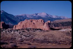
- Description:
- 25 f 11
- Subject:
- Cliffs, Trees, Buttes, Mountains, Shrubs, Pikes Peak (Colo.), Hills, Garden of the Gods (Colorado Springs, Colo.), and Rock formations
- Series:
- 23-52
- Creator:
- Cushman, Charles W., 1896-1972
- Date Created:
- 1952-10-29
- Genre:
- Landscape photographs
- Frame Number:
- 32
- County:
- El Paso
- Abstract:
- Farewell to Pike's Peak
- Call Number:
- P06324
- City:
- Colorado Springs
- Country:
- United States
- State/Province:
- Colorado
- Alternate Identifier:
- 2352.32
- Persistent URL:
- http://purl.dlib.indiana.edu/iudl/archives/cushman/P06324
- Holding Location:
- Bloomington - University Archives
Wells Library E460
1320 E 10th St.
Bloomington, IN 47405
Contact at archives@indiana.edu, 812-855-1127
-
- Description:
- 25 f 11
- Subject:
- Cliffs, Trees, Shrubs, Hills, Garden of the Gods (Colorado Springs, Colo.), and Rock formations
- Series:
- 23-52
- Creator:
- Cushman, Charles W., 1896-1972
- Date Created:
- 1952-10-29
- Genre:
- Identification photographs
- Frame Number:
- 31
- County:
- El Paso
- Abstract:
- Face of same slab
- Call Number:
- P06323
- City:
- Colorado Springs
- Country:
- United States
- State/Province:
- Colorado
- Alternate Identifier:
- 2352.31
- Persistent URL:
- http://purl.dlib.indiana.edu/iudl/archives/cushman/P06323
- Holding Location:
- Bloomington - University Archives
Wells Library E460
1320 E 10th St.
Bloomington, IN 47405
Contact at archives@indiana.edu, 812-855-1127
-
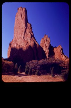
- Description:
- 25 f 11
- Subject:
- Grasses, Cliffs, Trees, Pines, Buttes, Rock formations, Hills, Garden of the Gods (Colorado Springs, Colo.), and Shrubs
- Series:
- 23-52
- Creator:
- Cushman, Charles W., 1896-1972
- Date Created:
- 1952-10-29
- Genre:
- Identification photographs
- Frame Number:
- 30
- County:
- El Paso
- Abstract:
- Pine & Chip
- Call Number:
- P06322
- City:
- Colorado Springs
- Country:
- United States
- State/Province:
- Colorado
- Alternate Identifier:
- 2352.30
- Persistent URL:
- http://purl.dlib.indiana.edu/iudl/archives/cushman/P06322
- Holding Location:
- Bloomington - University Archives
Wells Library E460
1320 E 10th St.
Bloomington, IN 47405
Contact at archives@indiana.edu, 812-855-1127
-
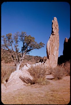
- Description:
- 25 f 6 Pola
- Subject:
- Cliffs, Garden of the Gods (Colorado Springs, Colo.), Dirt roads, Shrubs, Tall splinters, Shadows, Buttes, Grasses, Trees, and Rock formations
- Series:
- 23-52
- Creator:
- Cushman, Charles W., 1896-1972
- Date Created:
- 1952-10-29
- Genre:
- Landscape photographs
- Frame Number:
- 29
- County:
- El Paso
- Persons Pictured:
- Cushman, Charles W. (Charles Weever), 1896-1972
- Abstract:
- Two tall splinters
- Call Number:
- P06321
- City:
- Colorado Springs
- Country:
- United States
- State/Province:
- Colorado
- Physical Description:
- masked.
- Alternate Identifier:
- 2352.29
- Persistent URL:
- http://purl.dlib.indiana.edu/iudl/archives/cushman/P06321
- Holding Location:
- Bloomington - University Archives
Wells Library E460
1320 E 10th St.
Bloomington, IN 47405
Contact at archives@indiana.edu, 812-855-1127
-
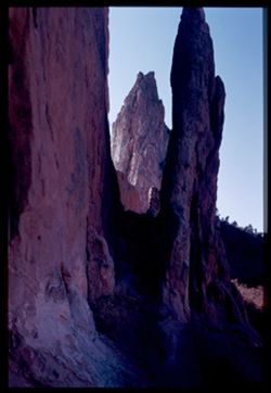
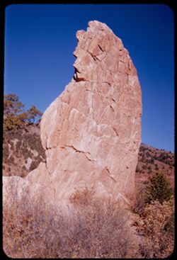
- Description:
- 25 f 5.6 Pola
- Subject:
- Cliffs, Garden of the Gods (Colorado Springs, Colo.), Shrubs, Shadows, Buttes, Rock formations, and Sentinel Rock (Colo.)
- Series:
- 23-52
- Creator:
- Cushman, Charles W., 1896-1972
- Date Created:
- 1952-10-29
- Genre:
- Snapshots
- Frame Number:
- 28
- County:
- El Paso
- Abstract:
- Open window
- Call Number:
- P06320
- City:
- Colorado Springs
- Country:
- United States
- State/Province:
- Colorado
- Physical Description:
- Image was originally mounted in a glass enclosure. Before digitization, the image was removed and placed in a Wess Plastic, Inc. brand, 2" x 2", pl...
- Alternate Identifier:
- 2352.28
- Persistent URL:
- http://purl.dlib.indiana.edu/iudl/archives/cushman/P06320
- Holding Location:
- Bloomington - University Archives
Wells Library E460
1320 E 10th St.
Bloomington, IN 47405
Contact at archives@indiana.edu, 812-855-1127
-
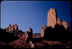
- Description:
- 25 f 6.3 Pola
- Subject:
- Cliffs, Trees, Shadows, Buttes, Shrubs, Garden of the Gods (Colorado Springs, Colo.), and Rock formations
- Series:
- 23-52
- Creator:
- Cushman, Charles W., 1896-1972
- Date Created:
- 1952-10-29
- Genre:
- Landscape photographs
- Frame Number:
- 27
- County:
- El Paso
- Abstract:
- In Garden of Gods
- Call Number:
- P06319
- City:
- Colorado Springs
- Country:
- United States
- State/Province:
- Colorado
- Alternate Identifier:
- 2352.27
- Persistent URL:
- http://purl.dlib.indiana.edu/iudl/archives/cushman/P06319
- Holding Location:
- Bloomington - University Archives
Wells Library E460
1320 E 10th St.
Bloomington, IN 47405
Contact at archives@indiana.edu, 812-855-1127
-
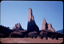
- Description:
- 25 f 9
- Subject:
- Crosses, Cliffs, Trees, Shadows, Buttes, Mountains, Rock formations, Hills, Garden of the Gods (Colorado Springs, Colo.), Meadows, and Shrubs
- Series:
- 23-52
- Creator:
- Cushman, Charles W., 1896-1972
- Date Created:
- 1952-10-29
- Genre:
- Landscape photographs
- Frame Number:
- 26
- County:
- El Paso
- Abstract:
- In Garden of Gods
- Call Number:
- P06318
- City:
- Colorado Springs
- Country:
- United States
- State/Province:
- Colorado
- Alternate Identifier:
- 2352.26
- Persistent URL:
- http://purl.dlib.indiana.edu/iudl/archives/cushman/P06318
- Holding Location:
- Bloomington - University Archives
Wells Library E460
1320 E 10th St.
Bloomington, IN 47405
Contact at archives@indiana.edu, 812-855-1127
-
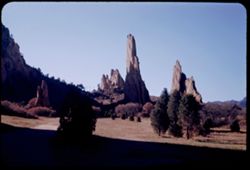
- Description:
- 25 f 9
- Subject:
- Meadows, Cliffs, Mountains, Shrubs, Trees, Buttes, Rock formations, and Garden of the Gods (Colorado Springs, Colo.)
- Series:
- 23-52
- Creator:
- Cushman, Charles W., 1896-1972
- Date Created:
- 1952-10-29
- Genre:
- Landscape photographs
- Frame Number:
- 25
- County:
- El Paso
- Abstract:
- In Garden of Gods
- Call Number:
- P06317
- City:
- Colorado Springs
- Country:
- United States
- State/Province:
- Colorado
- Alternate Identifier:
- 2352.25
- Persistent URL:
- http://purl.dlib.indiana.edu/iudl/archives/cushman/P06317
- Holding Location:
- Bloomington - University Archives
Wells Library E460
1320 E 10th St.
Bloomington, IN 47405
Contact at archives@indiana.edu, 812-855-1127
-
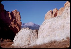
- Description:
- 25 f 11
- Subject:
- Cliffs, Shadows, Buttes, Mountains, Shrubs, Pikes Peak (Colo.), Garden of the Gods (Colorado Springs, Colo.), and Rock formations
- Series:
- 23-52
- Creator:
- Cushman, Charles W., 1896-1972
- Date Created:
- 1952-10-29
- Genre:
- Landscape photographs
- Frame Number:
- 24
- County:
- El Paso
- Abstract:
- Thru Gateway covered Pike's Peak
- Call Number:
- P06316
- City:
- Colorado Springs
- Country:
- United States
- State/Province:
- Colorado
- Alternate Identifier:
- 2352.24
- Persistent URL:
- http://purl.dlib.indiana.edu/iudl/archives/cushman/P06316
- Holding Location:
- Bloomington - University Archives
Wells Library E460
1320 E 10th St.
Bloomington, IN 47405
Contact at archives@indiana.edu, 812-855-1127
-
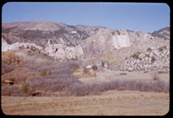
- Description:
- 25 f 11
- Subject:
- Grasses, Cliffs, Trees, Mountains, Buildings, Rock formations, Hills, Garden of the Gods (Colorado Springs, Colo.), Houses, and Shrubs
- Series:
- 23-52
- Creator:
- Cushman, Charles W., 1896-1972
- Date Created:
- 1952-10-29
- Genre:
- Landscape photographs
- Frame Number:
- 23
- County:
- El Paso
- Abstract:
- Rocks north of Garden of the Gods
- Call Number:
- P06315
- City:
- Colorado Springs
- Country:
- United States
- State/Province:
- Colorado
- Alternate Identifier:
- 2352.23
- Persistent URL:
- http://purl.dlib.indiana.edu/iudl/archives/cushman/P06315
- Holding Location:
- Bloomington - University Archives
Wells Library E460
1320 E 10th St.
Bloomington, IN 47405
Contact at archives@indiana.edu, 812-855-1127
-
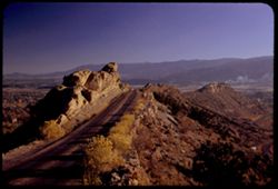
- Description:
- 25 f 6.3 Pola
- Subject:
- Roads, Mountains, Shrubs, Trees, Rocks, Rock formations, Boulders, and Buildings
- Series:
- 23-52
- Creator:
- Cushman, Charles W., 1896-1972
- Date Created:
- 1952-10-28
- Genre:
- Landscape photographs
- Frame Number:
- 22
- Street Address:
- Skyline Drive
- County:
- Fremont
- Abstract:
- Atop the comb of Skyline Dr.
- Call Number:
- P06314
- City:
- Canon City
- Country:
- United States
- State/Province:
- Colorado
- Alternate Identifier:
- 2352.22
- Persistent URL:
- http://purl.dlib.indiana.edu/iudl/archives/cushman/P06314
- Holding Location:
- Bloomington - University Archives
Wells Library E460
1320 E 10th St.
Bloomington, IN 47405
Contact at archives@indiana.edu, 812-855-1127
-
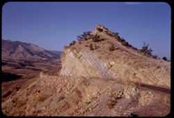
- Description:
- 25 f 11
- Subject:
- Rocks, Valleys, Roads, Trails & paths, Mountains, Shrubs, and Rock formations
- Series:
- 23-52
- Creator:
- Cushman, Charles W., 1896-1972
- Date Created:
- 1952-10-28
- Genre:
- Landscape photographs
- Frame Number:
- 19
- Street Address:
- Skyline Drive
- County:
- Fremont
- Abstract:
- Uptilted rock along skyline drive above Canon City
- Call Number:
- P06311
- City:
- Canon City
- Country:
- United States
- State/Province:
- Colorado
- Alternate Identifier:
- 2352.19
- Persistent URL:
- http://purl.dlib.indiana.edu/iudl/archives/cushman/P06311
- Holding Location:
- Bloomington - University Archives
Wells Library E460
1320 E 10th St.
Bloomington, IN 47405
Contact at archives@indiana.edu, 812-855-1127
-
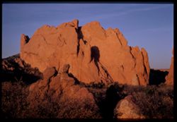
- Description:
- 25 f 11
- Subject:
- Red slab, Cliffs, Garden of the Gods (Colorado Springs, Colo.), Shrubs, Boulders, Shadows, Buttes, and Rock formations
- Series:
- 22-52
- Creator:
- Cushman, Charles W., 1896-1972
- Date Created:
- 1952-10-27
- Genre:
- Landscape photographs
- Frame Number:
- 30
- County:
- El Paso
- Persons Pictured:
- Cushman, Charles W. (Charles Weever), 1896-1972
- Abstract:
- & to the left
- Call Number:
- P06284
- City:
- Colorado Springs
- Country:
- United States
- State/Province:
- Colorado
- Physical Description:
- Image was originally mounted in a glass enclosure. Before digitization, the image was removed and placed in a Wess Plastic, Inc. brand, 2" x 2", pl...
- Alternate Identifier:
- 2252.30
- Persistent URL:
- http://purl.dlib.indiana.edu/iudl/archives/cushman/P06284
- Holding Location:
- Bloomington - University Archives
Wells Library E460
1320 E 10th St.
Bloomington, IN 47405
Contact at archives@indiana.edu, 812-855-1127
-
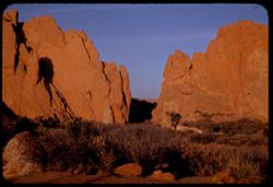
- Description:
- 25 f 11
- Subject:
- Rocks, Cliffs, Boulders, Shadows, Buttes, Shrubs, Garden of the Gods (Colorado Springs, Colo.), and Rock formations
- Series:
- 22-52
- Creator:
- Cushman, Charles W., 1896-1972
- Date Created:
- 1952-10-27
- Genre:
- Landscape photographs
- Frame Number:
- 29
- County:
- El Paso
- Abstract:
- Gateway from the West
- Call Number:
- P06283
- City:
- Colorado Springs
- Country:
- United States
- State/Province:
- Colorado
- Alternate Identifier:
- 2252.29
- Persistent URL:
- http://purl.dlib.indiana.edu/iudl/archives/cushman/P06283
- Holding Location:
- Bloomington - University Archives
Wells Library E460
1320 E 10th St.
Bloomington, IN 47405
Contact at archives@indiana.edu, 812-855-1127
-
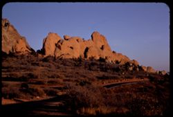
- Description:
- 25 f 9
- Subject:
- Roads, Cliffs, Garden of the Gods (Colorado Springs, Colo.), Shrubs, Boulders, Rocks, Buttes, and Rock formations
- Series:
- 22-52
- Creator:
- Cushman, Charles W., 1896-1972
- Date Created:
- 1952-10-27
- Genre:
- Landscape photographs
- Frame Number:
- 28
- County:
- El Paso
- Call Number:
- P06282
- City:
- Colorado Springs
- Country:
- United States
- State/Province:
- Colorado
- Alternate Identifier:
- 2252.28
- Persistent URL:
- http://purl.dlib.indiana.edu/iudl/archives/cushman/P06282
- Holding Location:
- Bloomington - University Archives
Wells Library E460
1320 E 10th St.
Bloomington, IN 47405
Contact at archives@indiana.edu, 812-855-1127
-
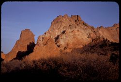
- Description:
- 25 f 9
- Subject:
- Cliffs, Buttes, Rock formations, Garden of the Gods (Colorado Springs, Colo.), and Shrubs
- Series:
- 22-52
- Creator:
- Cushman, Charles W., 1896-1972
- Date Created:
- 1952-10-27
- Genre:
- Landscape photographs
- Frame Number:
- 27
- County:
- El Paso
- Persons Pictured:
- Cushman, Charles W. (Charles Weever), 1896-1972
- Call Number:
- P06281
- City:
- Colorado Springs
- Country:
- United States
- State/Province:
- Colorado
- Alternate Identifier:
- 2252.27
- Persistent URL:
- http://purl.dlib.indiana.edu/iudl/archives/cushman/P06281
- Holding Location:
- Bloomington - University Archives
Wells Library E460
1320 E 10th St.
Bloomington, IN 47405
Contact at archives@indiana.edu, 812-855-1127
-
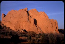
- Description:
- 25 f 11
- Subject:
- Cliffs, Trees, Buttes, Rock formations, and Garden of the Gods (Colorado Springs, Colo.)
- Series:
- 22-52
- Creator:
- Cushman, Charles W., 1896-1972
- Date Created:
- 1952-10-27
- Genre:
- Landscape photographs
- Frame Number:
- 26
- County:
- El Paso
- Abstract:
- Great rose slab
- Call Number:
- P06280
- Country:
- United States
- State/Province:
- Colorado
- Alternate Identifier:
- 2252.26
- Persistent URL:
- http://purl.dlib.indiana.edu/iudl/archives/cushman/P06280
- Holding Location:
- Bloomington - University Archives
Wells Library E460
1320 E 10th St.
Bloomington, IN 47405
Contact at archives@indiana.edu, 812-855-1127
-
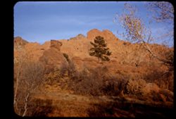
- Description:
- 25 f 8
- Subject:
- Cliffs, Trees, Shadows, Buttes, Tree limbs, Rock formations, Garden of the Gods (Colorado Springs, Colo.), and Shrubs
- Series:
- 22-52
- Creator:
- Cushman, Charles W., 1896-1972
- Date Created:
- 1952-10-27
- Genre:
- Landscape photographs
- Frame Number:
- 25
- County:
- El Paso
- Abstract:
- * Back to the Gods Garden
- Call Number:
- P06279
- City:
- Colorado Springs
- Country:
- United States
- State/Province:
- Colorado
- Physical Description:
- masked.
- Alternate Identifier:
- 2252.25
- Persistent URL:
- http://purl.dlib.indiana.edu/iudl/archives/cushman/P06279
- Holding Location:
- Bloomington - University Archives
Wells Library E460
1320 E 10th St.
Bloomington, IN 47405
Contact at archives@indiana.edu, 812-855-1127
-
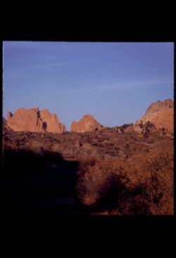
- Description:
- 25 f 9
- Subject:
- Trees, Shadows, Buttes, Rock formations, and Garden of the Gods (Colorado Springs, Colo.)
- Series:
- 22-52
- Creator:
- Cushman, Charles W., 1896-1972
- Date Created:
- 1952-10-27
- Genre:
- Landscape photographs
- Frame Number:
- 24
- County:
- El Paso
- Abstract:
- * Back to the Gods Garden
- Call Number:
- P06278
- City:
- Colorado Springs
- Country:
- United States
- State/Province:
- Colorado
- Physical Description:
- masked.
- Alternate Identifier:
- 2252.24
- Persistent URL:
- http://purl.dlib.indiana.edu/iudl/archives/cushman/P06278
- Holding Location:
- Bloomington - University Archives
Wells Library E460
1320 E 10th St.
Bloomington, IN 47405
Contact at archives@indiana.edu, 812-855-1127
-
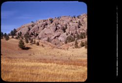
- Description:
- 25 f 11
- Subject:
- Rocky Mountains, Hills, Barbed wire, Mountains, Boulders, Rock formations, Fences, Trees, and Grasses
- Series:
- 22-52
- Creator:
- Cushman, Charles W., 1896-1972
- Date Created:
- 1952-10-27
- Genre:
- Landscape photographs
- Frame Number:
- 23
- Street Address:
- Colorado State Highway 143
- County:
- Teller
- Abstract:
- And to the left, this scene-the Rock is truly overlapped
- Call Number:
- P06277
- City:
- Cripple Creek and Florissant
- Country:
- United States
- State/Province:
- Colorado
- Physical Description:
- masked.
- Alternate Identifier:
- 2252.23
- Persistent URL:
- http://purl.dlib.indiana.edu/iudl/archives/cushman/P06277
- Holding Location:
- Bloomington - University Archives
Wells Library E460
1320 E 10th St.
Bloomington, IN 47405
Contact at archives@indiana.edu, 812-855-1127
-
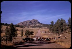
- Description:
- 25 f 11
- Subject:
- Grasses, Roads, Cowboys, Trees, Signs (Notices), Mountains, Rock formations, Cows, and Hills
- Series:
- 22-52
- Creator:
- Cushman, Charles W., 1896-1972
- Date Created:
- 1952-10-27
- Genre:
- Landscape photographs
- Frame Number:
- 21
- Street Address:
- Colorado State Highway 143
- County:
- Teller
- Abstract:
- Cows-lots of them-on Colo. 143
- Call Number:
- P06275
- City:
- Florissant and Cripple Creek
- Country:
- United States
- State/Province:
- Colorado
- Alternate Identifier:
- 2252.21
- Persistent URL:
- http://purl.dlib.indiana.edu/iudl/archives/cushman/P06275
- Holding Location:
- Bloomington - University Archives
Wells Library E460
1320 E 10th St.
Bloomington, IN 47405
Contact at archives@indiana.edu, 812-855-1127
-
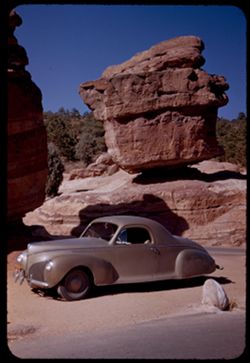
- Description:
- 25 f 9
- Subject:
- Rocks, Cliffs, Balanced Rock (Colo.), Automobiles, Trees, Boulders, Shadows, Rock formations, Hills, and Garden of the Gods (Colorado Springs, Colo.)
- Series:
- 22-52
- Creator:
- Cushman, Charles W., 1896-1972
- Date Created:
- 1952-10-27
- Genre:
- Identification photographs
- Frame Number:
- 5
- County:
- El Paso
- Abstract:
- Balanced Rock
- Call Number:
- P06259
- City:
- Colorado Springs
- Country:
- United States
- State/Province:
- Colorado
- Alternate Identifier:
- 2252.5
- Persistent URL:
- http://purl.dlib.indiana.edu/iudl/archives/cushman/P06259
- Holding Location:
- Bloomington - University Archives
Wells Library E460
1320 E 10th St.
Bloomington, IN 47405
Contact at archives@indiana.edu, 812-855-1127
-
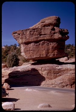
- Description:
- 25 f 9
- Subject:
- Rocks, Cliffs, Balanced Rock (Colo.), Trees, Boulders, Shadows, Rock formations, Hills, Garden of the Gods (Colorado Springs, Colo.), and Roads
- Series:
- 22-52
- Creator:
- Cushman, Charles W., 1896-1972
- Date Created:
- 1952-10-27
- Genre:
- Identification photographs
- Frame Number:
- 4
- County:
- El Paso
- Abstract:
- Balanced Rock
- Call Number:
- P06258
- City:
- Colorado Springs
- Country:
- United States
- State/Province:
- Colorado
- Alternate Identifier:
- 2252.4
- Persistent URL:
- http://purl.dlib.indiana.edu/iudl/archives/cushman/P06258
- Holding Location:
- Bloomington - University Archives
Wells Library E460
1320 E 10th St.
Bloomington, IN 47405
Contact at archives@indiana.edu, 812-855-1127
-

- Description:
- 25 f 6.3 Pola
- Subject:
- Rocks, Roads, Boulders, Buttes, Mountains, Rock formations, Pikes Peak (Colo.), Hills, Garden of the Gods (Colorado Springs, Colo.), Cliffs, and Shrubs
- Series:
- 22-52
- Creator:
- Cushman, Charles W., 1896-1972
- Date Created:
- 1952-10-27
- Genre:
- Landscape photographs
- Frame Number:
- 2
- County:
- El Paso
- Abstract:
- Pike's Peak through gateway of Garden of Gods
- Call Number:
- P06256
- City:
- Colorado Springs
- Country:
- United States
- State/Province:
- Colorado
- Alternate Identifier:
- 2252.2
- Persistent URL:
- http://purl.dlib.indiana.edu/iudl/archives/cushman/P06256
- Holding Location:
- Bloomington - University Archives
Wells Library E460
1320 E 10th St.
Bloomington, IN 47405
Contact at archives@indiana.edu, 812-855-1127
-
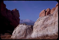
- Description:
- 25 f 11
- Subject:
- Pikes Peak (Colo.), Cliffs, Mountains, Shrubs, Buttes, Rock formations, and Garden of the Gods (Colorado Springs, Colo.)
- Series:
- 22-52
- Creator:
- Cushman, Charles W., 1896-1972
- Date Created:
- 1952-10-27
- Genre:
- Landscape photographs
- Frame Number:
- 1
- County:
- El Paso
- Abstract:
- Pike's Peak through gateway of Garden of Gods
- Call Number:
- P06255
- City:
- Colorado Springs
- Country:
- United States
- State/Province:
- Colorado
- Alternate Identifier:
- 2252.1
- Persistent URL:
- http://purl.dlib.indiana.edu/iudl/archives/cushman/P06255
- Holding Location:
- Bloomington - University Archives
Wells Library E460
1320 E 10th St.
Bloomington, IN 47405
Contact at archives@indiana.edu, 812-855-1127