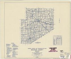
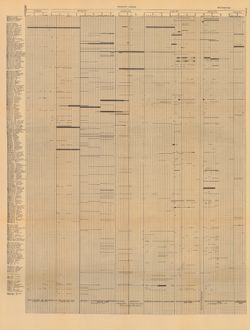
Geographic Subject: Decatur County (Ind.) and Topical Subject: Roads
Creator:
Indiana. State Highway Commission (1919-1953)
Publisher:
State Highway Commission of Indiana
Date Created:
1949
Identifier:
VAC3073-M-00697
Genre:
Road maps
Geographic Location:
Coordinates: W0854100 W0851800 N0392700 N0390800
Related URL:
Catalog URL: https://iucat.iu.edu/catalog/5704035
Abstract:
Blueline. "State roads revised to January 1, 1949." "Data obtained from Statewide Highway Planning Survey." Includes chart "Culture ...
Call Number:
G4093.D4P2 1949 .I53
Caption:
Imprint: [Indianapolis?] : State Highway Commission of Indiana. 1949.
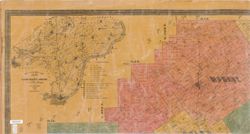
Topical Subject: Real property, Topical Subject: Landowners, and Geographic Subject: Clark County (Ind.)
Creator:
Davis, George W. (Civil Engineer)
Publisher:
Chas. A. McCann & David S. Koons
Date Created:
1875
Identifier:
VAC3073-M-00695
Genre:
Cadastral maps
Geographic Location:
Coordinates: W0860000 W0852500 N0383600 N0381600
Related URL:
Catalog URL: https://iucat.iu.edu/catalog/4685772
Abstract:
Cadastral map showing landowners. Originally printed in 3 sheets. Insets: Geological map of Clark County, Indiana -- Map of Indiana. Includes statistical tab...
Call Number:
G4093 .C4G46 1875 .D38
Caption:
Imprint: [Indianapolis] : Chas. A. McCann & David S. Koons, 1875
Physical Description:
Dimensions: 133 x 170 cm, pieces 48 x 89 cm and Scale: 1:31,680
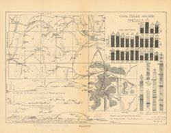
Relief shown by profile. Includes index map showing locations of coal fields in southern Martin County, 29 stratigraphic columns, correlation lines, and 4 ge...
Call Number:
G4093.M5H9 1898 .C63
Caption:
Imprint: [Indianapolis] : [Indiana Department of Geology and Natural Resources], [1899]
Physical Description:
Scale: Approximately 1:63,360 and Dimensions: 21 x 27 cm
Alternate Identifier:
Alternate ID: 390726IP and Title Control Number: a18214656
Title derived from captions. Chart showing stratigraphic measurements for paleontology samples collected around Tanner's Creek in Dearborn County and Ric...
Call Number:
G4091.C57 1908 .C86
Caption:
Imprint: [Indianapolis] : [Indiana Dept. of Geology and Natural Resources], [1908]
Physical Description:
Dimensions: 63 x 48 cm
Alternate Identifier:
Title Control Number: a18298805 and Alternate ID: 390726IP
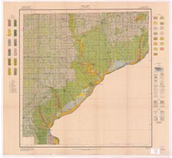
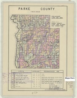
Geographic Subject: Parke County (Ind.) and Topical Subject: Land use
Creator:
Parke County (Ind.). Land Use Planning Committee
Publisher:
United States. Bureau of Agricultural Economics
Date Created:
1939
Identifier:
VAC3073-M-00689
Genre:
Thematic maps
Geographic Location:
Coordinates: W0872602 W0870034 N0395712 N0393617
Related URL:
Catalog URL: https://iucat.iu.edu/catalog/5126505
Abstract:
"Color reproduction by Bureau of Agricultural Economics, U.S.D.A." "3-30-39." Includes chart showing type of land use, acreage, and recom...
Call Number:
G4093.P2G4 1939 .P37
Caption:
Imprint: [Washington, D.C.?] : U.S. Bureau of Agricultural Economics, [1939]
Physical Description:
Dimensions: 17 x 16 cm, on sheet 28 x 22 cm and Scale: Scale not given.
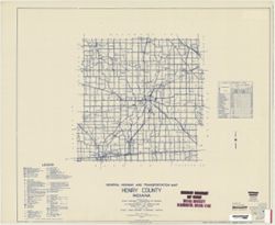
Topical Subject: Roads and Geographic Subject: Henry County (Ind.)
Creator:
Indiana. State Highway Commission (1919-1953)
Publisher:
State Highway Commission of Indiana
Date Created:
1949
Identifier:
VAC3073-M-00688
Genre:
Road maps
Geographic Location:
Coordinates: W0853600 W0852500 N0400500 N0394700
Related URL:
Catalog URL: https://iucat.iu.edu/catalog/5706069
Abstract:
Blueline. "State roads revised to January 1, 1949." "Data obtained from Statewide Highway Planning Survey." Includes chart "Culture ...
Call Number:
G4093.H6P2 1949 .I53
Caption:
Imprint: [Indianapolis?] : State Highway Commission of Indiana, 1949.

![Pike County [Indiana] land use map : preliminary](https://iiif.uits.iu.edu/iiif/2/rx914s61v%2Ffiles%2Fceecabf2-e7fb-4138-930c-04b192729886/full/250,/0/default.jpg)
