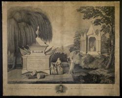
After a drawing by E.C. Brenton, Location Code: m2, "Engraved by W.H. Bassett", Caption: In memory of Commodore Oliver H. Perry, who captured the British Squ...
Indians of North America, United States--Maps, and American Indians
Series:
GLOVE - Local and Regional Maps
Creator:
Schoolcraft, Henry Rowe
Date Created:
1820
Identifier:
VAD5944-000030
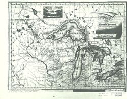
Abstract:
From: Henry R. Schoolcraft. Narrative journal of travels from Detroit northwest through the great chain of American lakes to the sources of the Mississippi ...
Call Number:
GLV146
Copyright Holder:
Public Domain
Country:
United States
Physical Description:
Scale of Miles 60 to an inch.
Holding Location:
Bloomington - Indiana University Museum of Archaeology and Anthropology 416 North Indiana Avenue Bloomington, IN 47408 Contact at iumaa@iu.edu, 812-855-6873
United States--Maps, Indians of North America, and American Indians
Series:
GLOVE - Local and Regional Maps
Creator:
Melish, John
Date Created:
1820
Identifier:
VAD5944-000029
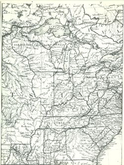
Abstract:
Map of the United States with the contiguous British & Spanish possessions complied from the last authorities by John Melish. Entered according to Act o...
Call Number:
GLV145
Copyright Holder:
Public Domain
Country:
United States
Physical Description:
Scale of Miles 60 to an inch.
Holding Location:
Bloomington - Indiana University Museum of Archaeology and Anthropology 416 North Indiana Avenue Bloomington, IN 47408 Contact at iumaa@iu.edu, 812-855-6873
American Indians, Indians of North America, United States--Maps, and Canada
Series:
GLOVE - Local and Regional Maps
Date Created:
1820
Identifier:
VAD5944-000025
Abstract:
Library of Congress U.S. 1820 Poirson Lowry Collection No. 750.
Call Number:
GLV141
Copyright Holder:
Public Domain
Country:
United States
Holding Location:
Bloomington - Indiana University Museum of Archaeology and Anthropology 416 North Indiana Avenue Bloomington, IN 47408 Contact at iumaa@iu.edu, 812-855-6873