Indiana University
Indiana University
IU
Skip to Content
Digital Collections
Toggle navigation
Digital
Collections
Login
Home
About
Contact
Search Digital Collections
Go
×
Search Constraints
Start Over
You searched for:
Date Created
1942
Remove constraint Date Created: 1942
Language
Russian
Remove constraint Language: Russian
« Previous |
1
-
10
of
129
|
Next »
Sort by relevance ▼
relevance ▼
recently updated
title ▲
title ▼
date created ▲
date created ▼
pages ▲
pages ▼
collection size ▲
collection size ▼
Number of results to display per page
10 per page
10
per page
20
per page
50
per page
100
per page
View results as:
List
Gallery
Masonry
Search Results
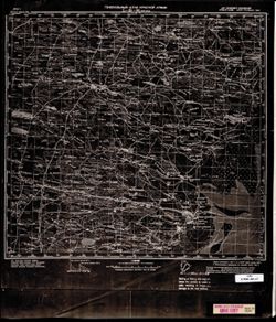
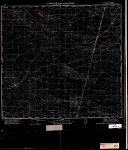
M-38-127 Солодники
M-38-117 Житкур
M-38-74 Зимняцкий
L-38-95 Лагань
L-38-94 Нарын-Худук
L-38-36 Вольное
L-38-22 Сасыколи
L-38-21 Онон-Боро
L-38-20 Баруны
L-38-17 Обильное
« Previous
Next »
1
2
3
4
5
…
12
13
Toggle facets
Limit your search
Type
Image
129
Subject
Topical Subject: Maps
129
Topical Subject: Soviet Union
129
Geographic Subject: Stavropol' Krai
8
Geographic Subject: Dagestan
3
Geographic Subject: Kalmykiya Republic
3
Geographic Subject: Chubutla
2
Geographic Subject: Dnipro
2
Geographic Subject: Vorovskolesskaya
2
Geographic Subject: Achikulak
1
Geographic Subject: Adyk
1
more
Subjects
»
Language
Russian
[remove]
129
Publisher
Генеральный штаб Красной Армии
125
Date Created
1942
[remove]
129
Pages
0-99 pages
129
Collections
Russian Military Topographic Map Collection
129
State
deposited
129
Campus
IU Bloomington
129
City
Аул-Чубутла (Aul-Chubutla)
2
Воровсколесская (Vorovskolesskaya)
2
Адык (Adyk)
1
Алагир (Alagir)
1
Александровское (Aleksandrovskoye)
1
Андра-Ата (Andra-Ata)
1
Апанасенковское (Apanasenkovskoye)
1
Архангельская (Arkhangel'skaya)
1
Архангельское (Arkhangelskoye)
1
Ачикулак (Achikulak)
1
more
Cities
»
Country
СССР (USSR)
127
Provenance
CIA Map Library
27
DMA Topographic Center, Army Map Service Library, OMAHA, Library of Congress Geography & Map Division
27
DMA Topographic Center, Army Map Service Library, Library of Congress Geography & Map Division
18
DMA Topographic Center, Army Map Service Library
10
DMA Topographic Center, Library of Congress G & M Division, OMAHA, Army Map Service Library
8
Army Map Service Library, Geographic Names Branch, Library of Congress G & M Division
4
CIA Map Library, Library of Congress G & M Division
4
CIA Map Library, Library of Congress Geography & Map Division
4
CIA Map Library, Atlasblatt
3
Library of Congress Geography & Map Division
3
more
Provenances
»
Holding Location
B-WELLS
129
State/Province
РСФСР (RSFSR)
82
Украинская ССР (Ukrainian Soviet Socialist Republic)
45
Калмыцкая АССР (Kalmyk Autonomous Soviet Socialist Republic)
39
Орджоникидзевский край (Ordzhonikidze kray)
35
Днепропетровская область (Dnipropetrovsk oblast)
32
Полтавская область (Poltava oblast)
15
Кизлярский округ (Kizlyar district)
13
Сталинградская область (Stalingrad oblast)
11
Харьковская область (Kharkiv oblast)
10
Кабардино-Балкарская АССР (Kabardino-Balkar Autonomous Soviet Socialist Republic)
6
more
State/Provinces
»