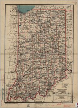
Prime meridians: Greenwich, Washington. At head of title: Department of the Interior, General Land Office, Wm. A.J. Sparks, Commissioner. Related name...
Call Number:
G4090 1886 .H4
Caption:
Imprint: [Washington, D.C.] : General Land Office, 1886
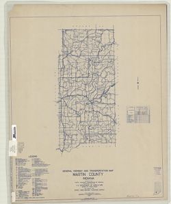
Geographic Subject: Martin County (Ind.) and Topical Subject: Roads
Creator:
Indiana. State Highway Commission (1919-1939)
Publisher:
State Highway Commission of Indiana
Date Created:
1949
Identifier:
VAC3073-M-00077
Genre:
Road maps
Geographic Location:
Coordinates: W0865500 W0864100 N0385400 N0383000
Related URL:
Catalog URL: https://iucat.iu.edu/catalog/5706861
Abstract:
Blueline. "State roads revised to January 1, 1949." "1937." "Data obtained from State-wide Highway Planning Survey." Includes ...
Call Number:
G4093.M5 P2 1949 .I53
Caption:
Imprint: [Indianapolis?] : State Highway Commission of Indiana, 1949.
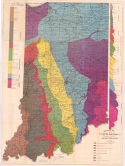
"Compiled from official records of the General Land Office, U. S. Geological Survey and other sources under the direction of I.P. Berthrong." Prime...
Call Number:
G4090 1916 .D5
Caption:
Imprint: [Washington, D.C.] : General Land Office, 1916.
Variant title: Geological map of Indiana, revised and corrected. 1 map and 2 sections on 1 sheet. Shows county seats, townships, towns & post offices, ra...
Call Number:
QE109 .A2 1884
Caption:
Imprint: Indianapolis : [Indiana Department of Geology and Natural History], [1885] and Imprint: Indianapolis : Wm. B. Burford, [1885]
Physical Description:
Dimensions: 85 x 63 cm and Scale: Approximately 1:570,240. 9 miles to the inch
Alternate Identifier:
Alternate ID: 390725IP and Title Control Number: a18437099
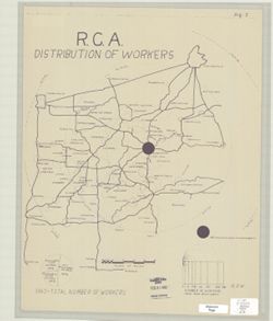
Topical Subject: Labor supply, Geographic Subject: Bloomington Region (Ind.), and Geographic Subject: Indiana
Publisher:
[publisher not identified]
Date Created:
1950
Identifier:
VAC3073-M-00074
Genre:
Thematic maps
Geographic Location:
Coordinates: W0872600 W0855400 N0394700 N0381800
Related URL:
Catalog URL: https://iucat.iu.edu/catalog/5296429
Abstract:
Blue line print. Shows numbers of R.C.A. Bloomington employees by home cities and towns with graduated circles. Includes graphs. Shows numbers of R.C.A. B...
Call Number:
G4094 .B5G8 1950 .R3
Caption:
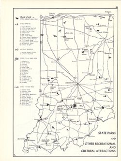
Imprint: [place of publication not identified] : [publisher not identified], [between 1950 and 1969?]
Physical Description:
Scale: Approximately 1:500,000 and Dimensions: 46 x 36 cm
Shows state parks and state recreational areas, national and state memorials, state fish & game areas, and state fishing areas. Includes index. Detach...
Call Number:
G4091.G52 1969 .K56
Caption:
Imprint: Bloomington, Indiana : Department of Geography, Indiana University, [1970]
Physical Description:
Dimensions: 26 x 18 cm, on sheet 28 x 21 cm and Scale: Approximately 1:1,850,000
Alternate Identifier:
Alternate ID: 317383IP and Title Control Number: a15938145
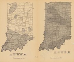
2 maps on one sheet. Shows rainfall over the state of Indiana in inches. "Fig. 2." Detached from: Water power of Indiana / W.M. Tucker. In India...
Call Number:
G4091.C88 1909 .T6
Caption:
Imprint: [Indianapolis] : [Indiana Department of Geology and Natural Resources], [1911]
Physical Description:
Scale: Scale not given. and Dimensions: on sheet 23 x 27 cm
Alternate Identifier:
Alternate ID: 390726IP and Title Control Number: a18307828
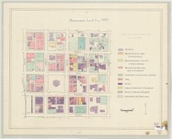
Geographic Subject: Bloomington (Ind.) and Topical Subject: Land use
Publisher:
[publisher not identified}
Date Created:
1978
Identifier:
VAC3073-M-00067
Genre:
Maps
Geographic Location:
Coordinates: W0863214 W0863151 N0391011 N0390955
Related URL:
Catalog URL: https://iucat.iu.edu/catalog/5300360
Abstract:
Shows the area from Morton Street on the west to Lincoln Street on the east, and Eighth Street on the north and Fourth Street on the South. Pen-and-ink ...
Call Number:
G4094.B5 G4 1978 .B5
Caption:
Imprint: [place of publication not identified] : [publisher not identified], [1978?]
Physical Description:
Dimensions: 52 x 68 cm and Scale: Approximately 1:1,200