
Search Constraints
You searched for:
Subject
Geographic Subject: Grant County (Ind.)
Remove constraint Subject: Geographic Subject: Grant County (Ind.)
1 - 6 of 6
Search Results
-
- Subject:
- Topical Subject: Soils and Geographic Subject: Grant County (Ind.)
- Creator:
- Hertenstein, Earl, Hurst, Lewis A. (Lewis Alexander), 1874-, Middleton, Philip (Soil surveyor), Watkins, W. I. (William Isaac), 1888-1973, Tharp, W. E. (Will...
- Publisher:
- Indiana. Department of Geology and Natural Resources
- Date Created:
- 1916
- Identifier:
- VAC3073-M-01510
- Genre:
- Thematic maps
- Geographic Location:
- Coordinates: W0855153 W0852639 N0403913 N0402242
- Related URL:
- Catalog URL: https://iucat.iu.edu/catalog/16142796
- Abstract:
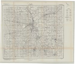
- "Field Operations Bureau of Soils, 1915"--Lower margin. Detached from: Soil survey of Grant County, Indiana / L.A. Hurst [and others]. In 40th A...
- Call Number:
- G4093.G6J3 1915 .H88
- Caption:
- Imprint: [Indianapolis] : Indiana Department of Geology, [1916] and Imprint: [Fort Wayne] : [Fort Wayne Printing Company], [1916]
- Physical Description:
- Scale: Approximately 1:63,360. 1 in. = 1 mile and Dimensions: 46 x 53 cm
- Alternate Identifier:
- Title Control Number: a16142796 and Alternate ID: 390726IP
- Persistent URL:
- https://purl.dlib.indiana.edu/iudl/images/VAC3073/VAC3073-M-01510
- Provenance:
- 40th Annual Report (1915) / Indiana. Department of Geology and Natural Resources.
-
- Subject:
- Geographic Subject: Grant County (Ind.) and Topical Subject: Soils
- Creator:
- Hurst, Lewis A. (Lewis Alexander), 1874-, Middleton, Philip (Soil surveyor), Hertenstein, Earl, Indiana. Department of Geology and Natural Resources, Tharp, ...
- Publisher:
- United States. Bureau of Soils
- Date Created:
- 1915
- Identifier:
- VAC3073-M-00933
- Genre:
- Thematic maps
- Geographic Location:
- Coordinates: W0855200 W0852700 N0403900 N0402300
- Related URL:
- Catalog URL: https://iucat.iu.edu/catalog/16142796
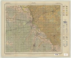
- Abstract:
- U.S. Dept. of Agriculture, Bureau of Soils [and] State of Indiana, Department of Geology , soils surveyed by Lewis A. Hurst, W.I. Watkins, and W.E. Tharp, of...
- Call Number:
- G4093 .G6J3 1915 .H87
- Caption:
- Imprint: [Washington, D.C.?] : Bureau of Soils, [1915]
- Physical Description:
- Scale: 1:63,360. 1 inch = 1 mile and Dimensions: 48 x 57 cm
- Alternate Identifier:
- Title Control Number: a16142796 and Alternate ID: CAY2874BB
- Persistent URL:
- https://purl.dlib.indiana.edu/iudl/images/VAC3073/VAC3073-M-00933
-
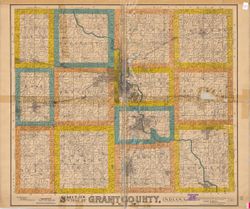
- Subject:
- Geographic Subject: Grant County (Ind.), Topical Subject: Real property, and Topical Subject: Landowners
- Creator:
- Smith, Ansel R.
- Publisher:
- Smith, Ansel R.
- Date Created:
- 1906
- Identifier:
- VAC3073-M-00872
- Genre:
- Cadastral maps
- Geographic Location:
- Coordinates: W0855153 W0852639 N0403913 N0402242
- Related URL:
- Catalog URL: https://iucat.iu.edu/catalog/7065595
- Abstract:
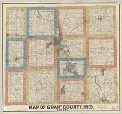
- Cadastral map showing landowners. "F.W. White, draftsman."
- Call Number:
- G4093.G6G46 1906 .S65
- Caption:
- Imprint: Marion, Ind. : Ansel R. Smith, 1906.
- Physical Description:
- Dimensions: 105 x 115 cm and Scale: 1:31,680
- Alternate Identifier:
- Title Control Number: a7065595
- Persistent URL:
- https://purl.dlib.indiana.edu/iudl/images/VAC3073/VAC3073-M-00872
-
- Subject:
- Geographic Subject: Grant County (Ind.) and Topical Subject: Roads
- Creator:
- Indiana. State Highway Commission (1919-1953)
- Publisher:
- State Highway Commission of Indiana
- Date Created:
- 1949
- Identifier:
- VAC3073-M-00309
- Genre:
- Road maps
- Geographic Location:
- Coordinates: W0855200 W0852700 N0403900 N0402300
- Related URL:
- Catalog URL: https://iucat.iu.edu/catalog/5706036
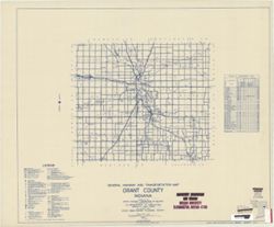
- Abstract:
- Blueline. "State roads revised to January 1, 1949." "1937." "Data obtained from Statewide Highway Planning Survey." Includes lo...
- Call Number:
- G4093.G6P2 1949 .I53
- Caption:
- Imprint: [Indianapolis?] : State Highway Commission of Indiana, 1949.
- Physical Description:
- Scale: 1:130,000 and Dimensions: 44 x 52 cm
- Alternate Identifier:
- Title Control Number: a5706036
- Persistent URL:
- https://purl.dlib.indiana.edu/iudl/images/VAC3073/VAC3073-M-00309
-
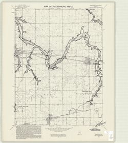
- Subject:
- Topical Subject: Floods, Geographic Subject: Miami County (Ind.), Geographic Subject: Grant County (Ind.), Topical Subject: Floodplains, Geographic Subject: ...
- Creator:
- Geological Survey (U.S.) and United States. Federal Insurance Administration
- Publisher:
- Geological Survey (U.S.)
- Date Created:
- 1974
- Identifier:
- VAC3073-M-00290
- Genre:
- Quadrangle maps, 7.5 minute topographic maps, and Topographic maps
- Geographic Location:
- Coordinates: W0855230 W0854500 N0403730 N0403000
- Related URL:
- Catalog URL: https://iucat.iu.edu/catalog/18416334
- Abstract:
- Filing title: Sweetser, Ind. Relief shown by contours and spot heights. Contour interval 10 feet. Includes quadrangle location map. Shows portion of Grant, M...
- Call Number:
- G4091.C32 s24 .G4 Sweetser, Ind. 1974
- Caption:
- Imprint: Washington, D.C. : Interior--Geological Survey, [1974]
- Physical Description:
- Dimensions: 59 x 45 or smaller and Scale: 1:24,000
- Alternate Identifier:
- Alternate ID: CAW5372BB and Title Control Number: a18416334
- Persistent URL:
- https://purl.dlib.indiana.edu/iudl/images/VAC3073/VAC3073-M-00290
- Provenance:
- United States Department of the Interior, Geological Survey. Map of flood-prone areas : [Indiana]. Washington, D.C. : The Survey, 1969-.
-
- Subject:
- Geographic Subject: Grant County (Ind.) and Topical Subject: Landowners
- Creator:
- White, Frank W., C.E.
- Publisher:
- Smith, Ansel R.
- Date Created:
- 1920
- Identifier:
- VAC3073-M-00190
- Genre:
- Cadastral maps
- Geographic Location:
- Coordinates: W0855200 W0852700 N0403900 N0402300
- Related URL:
- Catalog URL: https://iucat.iu.edu/catalog/4662018
- Abstract:
- Cadastral map showing landowners. "Compiled and made from county records and surveys."
- Call Number:
- G4093 .G6G46 1920 .W485
- Caption:
- Imprint: Marion, Ind.: Ansel R. Smith, 1920.
- Physical Description:
- Scale: 1:31,680 and Dimensions: 105 x 116 cm
- Alternate Identifier:
- Title Control Number: CAG9321BB
- Persistent URL:
- https://purl.dlib.indiana.edu/iudl/images/VAC3073/VAC3073-M-00190
