
Search Constraints
You searched for:
Subject
Plants
Remove constraint Subject: Plants
State/Province
Oregon
Remove constraint State/Province: Oregon
« Previous |
1 - 10 of 18
|
Next »
Search Results
-
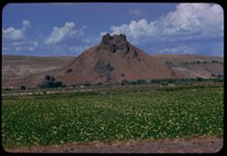
- Description:
- 100 f 8 TL
- Subject:
- Agriculture, Mountains, Trees, Plants, Rock formations, Hills, and Clouds
- Series:
- 11-58
- Creator:
- Cushman, Charles W., 1896-1972
- Date Created:
- 1958-06-14
- Genre:
- Landscape photographs
- Frame Number:
- 18
- Street Address:
- United States Highway 20
- County:
- Malheur
- Abstract:
- Rock like a pussy cat - east of Vale
- Call Number:
- P09993
- City:
- Vale
- Country:
- United States
- Alternate Identifier:
- 1158.18
- Holding Location:
- Bloomington - University Archives
Wells Library E460
1320 E 10th St.
Bloomington, IN 47405
Contact at archives@iu.edu, 812-855-1127 - State/Province:
- Oregon
- Persistent URL:
- http://purl.dlib.indiana.edu/iudl/archives/cushman/P09993
-
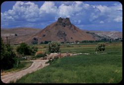
- Description:
- 100 f 7 TL
- Subject:
- Mountains, Dirt roads, Trees, Plants, Rock formations, and Clouds
- Series:
- 11-58
- Creator:
- Cushman, Charles W., 1896-1972
- Date Created:
- 1958-06-14
- Genre:
- Landscape photographs
- Frame Number:
- 17
- Street Address:
- United States Highway 20
- County:
- Malheur
- Abstract:
- Rock like a pussy cat - east of Vale
- Call Number:
- P09992
- City:
- Vale
- Country:
- United States
- Alternate Identifier:
- 1158.17
- Holding Location:
- Bloomington - University Archives
Wells Library E460
1320 E 10th St.
Bloomington, IN 47405
Contact at archives@iu.edu, 812-855-1127 - State/Province:
- Oregon
- Persistent URL:
- http://purl.dlib.indiana.edu/iudl/archives/cushman/P09992
-
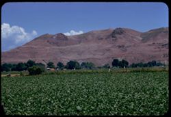
- Description:
- 100 f 8 TL
- Subject:
- Hills, Trees, Plants, Farms, and Clouds
- Series:
- 11-58
- Creator:
- Cushman, Charles W., 1896-1972
- Date Created:
- 1958-06-14
- Genre:
- Landscape photographs
- Frame Number:
- 16
- County:
- Malheur
- Abstract:
- Ridge above Vale
- Call Number:
- P09991
- City:
- Vale
- Country:
- United States
- Alternate Identifier:
- 1158.16
- Holding Location:
- Bloomington - University Archives
Wells Library E460
1320 E 10th St.
Bloomington, IN 47405
Contact at archives@iu.edu, 812-855-1127 - State/Province:
- Oregon
- Persistent URL:
- http://purl.dlib.indiana.edu/iudl/archives/cushman/P09991
-
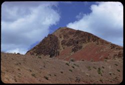
- Description:
- 100 f 6.3 TL
- Subject:
- Rock formations, Mountains, Plants, Malheur River (Or.), Volcanic rock, and Clouds
- Series:
- 11-58
- Creator:
- Cushman, Charles W., 1896-1972
- Date Created:
- 1958-06-14
- Genre:
- Landscape photographs
- Frame Number:
- 13
- County:
- Malheur
- Abstract:
- Tip of nearby
- Call Number:
- P09988
- Country:
- United States
- Alternate Identifier:
- 1158.13
- Holding Location:
- Bloomington - University Archives
Wells Library E460
1320 E 10th St.
Bloomington, IN 47405
Contact at archives@iu.edu, 812-855-1127 - State/Province:
- Oregon
- Persistent URL:
- http://purl.dlib.indiana.edu/iudl/archives/cushman/P09988
-
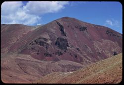
- Description:
- 100 f 6.3 TL
- Subject:
- Canyons, Mountains, Clouds, Malheur River (Or.), and Plants
- Series:
- 11-58
- Creator:
- Cushman, Charles W., 1896-1972
- Date Created:
- 1958-06-14
- Genre:
- Landscape photographs
- Frame Number:
- 12
- County:
- Malheur and Harney
- Abstract:
- Great red hunk
- Call Number:
- P09987
- City:
- Burns
- Country:
- United States
- Alternate Identifier:
- 1158.12
- Holding Location:
- Bloomington - University Archives
Wells Library E460
1320 E 10th St.
Bloomington, IN 47405
Contact at archives@iu.edu, 812-855-1127 - State/Province:
- Oregon
- Persistent URL:
- http://purl.dlib.indiana.edu/iudl/archives/cushman/P09987
-
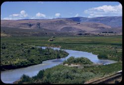
- Description:
- 100 f 6.3 TL
- Subject:
- Shrubs, Hills, Malheur River (Or.), Rivers, and Plants
- Series:
- 10-58
- Creator:
- Cushman, Charles W., 1896-1972
- Date Created:
- 1958-06-14
- Genre:
- Landscape photographs
- Frame Number:
- 34
- County:
- Malheur
- Abstract:
- N. FK. Malheur, nr Juntura
- Call Number:
- P09972
- City:
- Juntura
- Country:
- United States
- Alternate Identifier:
- 1058.34
- Holding Location:
- Bloomington - University Archives
Wells Library E460
1320 E 10th St.
Bloomington, IN 47405
Contact at archives@iu.edu, 812-855-1127 - State/Province:
- Oregon
- Persistent URL:
- http://purl.dlib.indiana.edu/iudl/archives/cushman/P09972
-
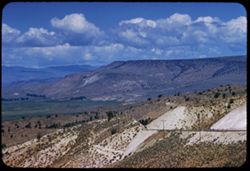
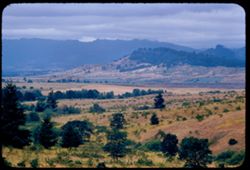
- Description:
- 100 f 8 TL
- Subject:
- Malheur River Valley (Or.), Valleys, Mountains, Clouds, Hills, and Plants
- Series:
- 10-58
- Creator:
- Cushman, Charles W., 1896-1972
- Date Created:
- 1958-06-14
- Genre:
- Landscape photographs
- Frame Number:
- 31
- Street Address:
- United States Highway 20
- County:
- Harney
- Abstract:
- West down US 20 across Malheur river
- Call Number:
- P09970
- City:
- Burns
- Country:
- United States
- Alternate Identifier:
- 1058.31
- Holding Location:
- Bloomington - University Archives
Wells Library E460
1320 E 10th St.
Bloomington, IN 47405
Contact at archives@iu.edu, 812-855-1127 - State/Province:
- Oregon
- Persistent URL:
- http://purl.dlib.indiana.edu/iudl/archives/cushman/P09970
-
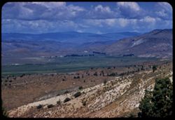
- Description:
- 100 f 8 TL
- Subject:
- Malheur River Valley (Or.), Valleys, Mountains, Clouds, Hills, and Plants
- Series:
- 10-58
- Creator:
- Cushman, Charles W., 1896-1972
- Date Created:
- 1958-06-14
- Genre:
- Landscape photographs
- Frame Number:
- 30
- County:
- Harney
- Abstract:
- Ranches in Malheur river valley seen from east height
- Call Number:
- P09969
- City:
- Burns
- Country:
- United States
- Alternate Identifier:
- 1058.30
- Holding Location:
- Bloomington - University Archives
Wells Library E460
1320 E 10th St.
Bloomington, IN 47405
Contact at archives@iu.edu, 812-855-1127 - State/Province:
- Oregon
- Persistent URL:
- http://purl.dlib.indiana.edu/iudl/archives/cushman/P09969
-
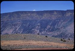
- Description:
- 100 f 6 TL
- Subject:
- Volcanic rock, Mountains, and Plants
- Series:
- 10-58
- Creator:
- Cushman, Charles W., 1896-1972
- Date Created:
- 1958-06-13
- Genre:
- Landscape photographs
- Frame Number:
- 28
- County:
- Lake
- Abstract:
- Yellow on a dark lava ridge
- Call Number:
- P09967
- Country:
- United States
- Alternate Identifier:
- 1058.28
- Holding Location:
- Bloomington - University Archives
Wells Library E460
1320 E 10th St.
Bloomington, IN 47405
Contact at archives@iu.edu, 812-855-1127 - State/Province:
- Oregon
- Persistent URL:
- http://purl.dlib.indiana.edu/iudl/archives/cushman/P09967
-
- Description:
- 100 f 5.6 tl
- Subject:
- Trees, Plains, Mountains, Shrubs, Clouds, Hills, and Plants
- Series:
- 10-56
- Creator:
- Cushman, Charles W., 1896-1972
- Date Created:
- 1956-07-13
- Genre:
- Landscape photographs
- Frame Number:
- 14
- County:
- Douglas
- Abstract:
- Country W. of Oakland
- Call Number:
- P08874
- City:
- Oakland
- Country:
- United States
- Alternate Identifier:
- 1056.14
- Holding Location:
- Bloomington - University Archives
Wells Library E460
1320 E 10th St.
Bloomington, IN 47405
Contact at archives@iu.edu, 812-855-1127 - State/Province:
- Oregon
- Persistent URL:
- http://purl.dlib.indiana.edu/iudl/archives/cushman/P08874