Indiana University
Indiana University
IU
Skip to Content
Digital Collections
Toggle navigation
Digital
Collections
Login
Home
About
Contact
Search Digital Collections
Go
×
Search Constraints
Start Over
You searched for:
Subject
Topical Subject: Maps
Remove constraint Subject: Topical Subject: Maps
« Previous |
1
-
10
of
4,137
|
Next »
Sort by relevance ▼
relevance ▼
recently updated
title ▲
title ▼
date created ▲
date created ▼
pages ▲
pages ▼
collection size ▲
collection size ▼
Number of results to display per page
10 per page
10
per page
20
per page
50
per page
100
per page
View results as:
List
Gallery
Masonry
Search Results
1.
Campus Development
2.
Campus Development Plan
3.
President Tubman observing a model with other dignitaries
4.
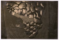
Man explains a model of ruins to President Tubman and other dignitaries
5.
President Tubman an a group of dignitaries look a documents in a glass case
6.
Map of Africa showing Liberia and Tanzania holding hands
7.
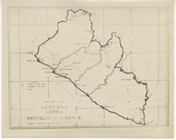
Map of Republic of Liberia
8.
Geographical map of Liberia
9.
N-37-52-Г Горшково
10.
N-37-52-В/Г Ст. Лаптево
« Previous
Next »
1
2
3
4
5
…
413
414
Toggle facets
Limit your search
Type
Image
4,137
Creator
Agency: Orphan Work
3
Agency: Foto Blanco
1
Agency: Lumos Film Reparto Fotografico
1
Agency: Palladium-Item
1
Agency: U.S.A Operations Mission
1
Geological Survey (U.S.)
1
Photographer: Davis, Griff
1
Subject
Topical Subject: Maps
[remove]
4,137
Topical Subject: Soviet Union
4,128
Geographic Subject: Republic of Crimea
24
Geographic Subject: Estonia
10
Geographic Subject: Stavropol' Krai
9
Geographic Subject: Kalmykiya Republic
6
Geographic Subject: Shet district
6
Geographic Subject: Vysokoye
6
Geographic Subject: Haradok
5
Geographic Subject: Lyuban
5
more
Subjects
»
Language
Russian
4,128
Publisher
Генеральный штаб Красной Армии
1,420
Генеральный штаб РККА
1,000
Управление военных топографов
465
Управление военных топографов РККА
462
Главное управление геодезии и картографии при СНК СССР
187
Военно-топографическое управление
186
Главное Управление Геодезии и Картографии при СНК СССР
127
Главное управление государственной съемки и картографии НКВД СССР
74
Itä-Karjalan kartasto
55
Главное геодезическое управление
19
more
Publishers
»
Date Created
1941
1,070
1940
424
1942
129
1939
73
1932
53
1930
51
1938
51
1936
49
1931
46
1943
39
more
Date Createds
»
Pages
0-99 pages
4,137
Collections
Russian Military Topographic Map Collection
4,128
William V. S. Tubman Photograph Collection
6
IU East Campus Archives Image Collection
2
Indiana Historic Maps
1
State
deposited
4,120
Campus
IU Bloomington
4,135
IU East
2
City
Слобода (Sloboda)
6
Любань (Lyuban)
5
Рудня (Rudnya)
5
Дубровка (Dubrovka)
4
Ельня (Yelnya)
4
Каменка (Kamenka)
4
Ломазы (Łomazy)
4
Остров (Ostrov)
4
Островно (Ostrovno)
4
Погост (Pogost)
4
more
Cities
»
Country
СССР (USSR)
2,757
Польша (Poland)
242
Германия (Восточная Пруссия) (Germany (East Prussia))
239
Германия (Germany)
219
Эстония (Estonia)
211
Финляндия (Finland)
121
Литва (Lithuania)
115
Латвия (Latvia)
108
Область государственных интересов Германии (Region of German state interest)
92
Восточная Пруссия (East Prussia)
73
more
Countries
»
Provenance
DMA Topographic Center, Army Map Service Library, OMAHA, Library of Congress Geography & Map Division
904
DMA Topographic Center, Army Map Service Library, OMAHA
416
Army Map Service Library, OMAHA, Library of Congress Geography & Map Division
349
DMA Topographic Center, Army Map Service Library, Library of Congress Geography & Map Division
272
DMA Topographic Center, Army Map Service Library
221
M. I. Map Library
179
CIA Map Library
172
CIA Map Branch -- Received
148
M. I. Map Library, G000-30, GS, RA
115
Army Map Service Library, Library of Congress Geography & Map Division, OMAHA
107
more
Provenances
»
Holding Location
B-WELLS
4,129
EAST
2
State/Province
РСФСР (RSFSR)
1,382
Белорусская ССР (Byelorussian Soviet Socialist Republic)
596
Украинская ССР (Ukrainian Soviet Socialist Republic)
566
Ленинградская область (Leningrad oblast)
349
Западная область (Western oblast)
195
Калининская область (Kalinin oblast)
165
Смоленская область (Smolensk oblast)
145
Область государственных интересов Германии (Region of German state interests)
112
Карельская АССР (Karelian Autonomous Soviet Socialist Republic)
107
Орловская область (Oryol oblast)
98
more
State/Provinces
»