
Image
Map of the City of Gary and vicinity, Lake County Indiana Public Deposited
- Genre
- Thematic maps
- Location
- Coordinates: W0872601 W0871319 N0413919 N0413118
- Related URL
- Abstract
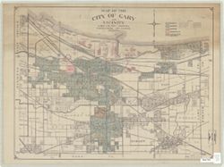
- Title supplied by cataloger. Produced as a class project in the Indiana University, Geography Department. Land use hand colored in colored pencil. Base map: Gary (Ind.). Dept. of City Engineer. Map of the City of Gary and vicinity. [1950].
- Call Number
- G4094.G2G4 1950 .G85
- Caption
- Imprint: [Place of publication not identified]: [publisher not identified], [195-?]
- Filename
- VAC3073-M-00712
- Subject
- Geographic Subject: Lake County (Ind.)
- Topical Subject: Land use
- Geographic Subject: Gary (Ind.)
- Geographic Subject: Gary Region (Ind.)
- Title
- Map of the City of Gary and vicinity, Lake County Indiana
- Producer
- Guiney, Donald
- Physical Description
- Dimensions: 53 x 70 cm
- Scale: 1:29,000
- Persistent Identifier
- Campus
- IU Bloomington
- Date Created
- 1950
- Publisher
- [publisher not identified]
Relationships
Relationships
- In Collection:
Items
Show Item Images
| Thumbnail | Title | Date Uploaded | Visibility | Actions |
|---|---|---|---|---|
|
VAC3073-M-00712.jp2 | 2023-09-25 | Public |
|