
Image
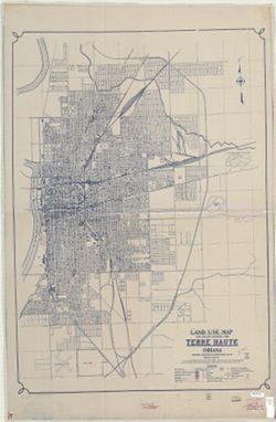
Land use map real property inventory, 1935 Terre Haute, Indiana Public Deposited
- Genre
- Thematic maps
- Location
- Coordinates: W0872810 W0871636 N0393142 N0392405
- Related URL
- Abstract
- Blueline. "Project 84-F2-79.""This map shows the type of use of all land frontage. The Depth of Structures was disregarded. No attempt was made to distinguish single structures in a series of the same type."
- Call Number
- G4094.T4G4 1935 .I53
- Caption
- Imprint: [Indianapolis?] : Governor's Commission on Unemployment Relief, [1935?]
- Filename
- VAC3073-M-00366
- Subject
- Topical Subject: Land use
- Geographic Subject: Terre Haute (Ind.)
- Title
- Land use map real property inventory, 1935 Terre Haute, Indiana
- Producer
- Indiana. Governor's Commission on Unemployment Relief
- Physical Description
- Dimensions: 121 x 86 cm
- Scale: Approximately 1:18,200
- Item Identifiers
- Title Control Number: a7511454
- Persistent Identifier
- Campus
- IU Bloomington
- Date Created
- 1935
- Publisher
- Indiana. Governor's Commission on Unemployment Relief
Relationships
Relationships
- In Collection:
Items
Show Item Images
| Thumbnail | Title | Date Uploaded | Visibility | Actions |
|---|---|---|---|---|
|
VAC3073-M-00366.jp2 | 2023-10-18 | Public |
|