
Image
Kentucky-Indiana Uniontown quadrangle [1917 printing with vegetation] Public Deposited
- Genre
- Quadrangle maps
- Topographic maps
- 15 minute topographic maps
- Location
- Coordinates: W0880000 W0874500 N0380000 N0374500
- Related URL
- Abstract
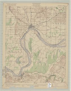
- R.B. Marshall, chief geographer , W.H. Herron, geographer in charge , topography by C.W. Goodlove, R.M. Herrington and W.S. Gehres , control by U.S. Coast and Geodetic Survey Corps of Engineers U.S. Army, Geo. T. Hawkins, J.R. Ellis, S.R. Archer, E.C. Bibbee and Marvin Lee. Filing title: Uniontown, Ky.-Ind. Edition of 1917. Polyconic projection. Relief shown by contours and spot heights. Includes map of areas surveyed by Goodlove, Herrington, and Gehres. Shows portions of Posey County, Indiana, and Henderson and Union counties in Ohio. Surveyed in 1914. Reprinted 1929, 1941. At head of map: "Topography, State of Kentucky, Geological Survey, J. B. Hoeing, State Geologist". Surveyed in cooperation with the state of Kentucky.
- Call Number
- G4090 s62 .G4 Uniontown 1917
- Caption
- Imprint: [Washington, D.C.] : U.S. Geological Survey, [1917]
- Filename
- VAC3073-M-01334
- Subject
- Topical Subject: Vegetation mapping
- Geographic Subject: Henderson County (Ky.)
- Geographic Subject: Posey County (Ind.)
- Geographic Subject: Union County (Ky.)
- Title
- Kentucky-Indiana Uniontown quadrangle [1917 printing with vegetation]
- Producer
- Kentucky Geological Survey
- U.S. Coast and Geodetic Survey
- Herron, W. H. (William Harrison), 1865-
- United States. Army. Corps of Engineers
- Hawkins, Geo. T. (George T.)
- Gehres, W. S. (Wilmer Sherman), 1887-1963
- Ellis, J. R. (Topographer)
- Geological Survey (U.S.)
- Marshall, R. B. (Robert Bradford), 1867-1949
- Goodlove, C. W.
- Herrington, R. M. (Russell McKee), 1890-1977
- Physical Description
- Scale: 1:62,500
- Dimensions: 45 x 42 cm or smaller
- Item Identifiers
- Title Control Number: a18415442
- Persistent Identifier
- Campus
- IU Bloomington
- Date Created
- 1917
- Provenance
- Part of Geological Survey (U.S.). Indiana 1:62,500.
- Publisher
- Geological Survey (U.S.)
Relationships
Relationships
- In Collection:
Items
Show Item Images
| Thumbnail | Title | Date Uploaded | Visibility | Actions |
|---|---|---|---|---|
|
VAC3073-M-01334.jp2 | 2023-09-28 | Public |
|