
Image
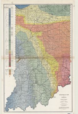
Geological map of Indiana Public Deposited
- Genre
- Geological maps
- Location
- Coordinates: W0870000 W0850000 N0410000 N0380000
- Related URL
- Abstract
- "Conservation Commission, Stanley Coulter, Chairman." "The based used...is the Ryse map, which has been modified." Includes geologic cross sections.
- Call Number
- G4091.C5 1932 .I53
- Caption
- Imprint: [Indianapolis] : Dept. of Conservation, State of Indiana, 1932.
- Filename
- VAC3073-M-00989
- Subject
- Geographic Subject: Indiana
- Topical Subject: Geology
- Title
- Geological map of Indiana
- Producer
- Indiana. Division of Geology
- Physical Description
- Dimensions: 177 x 112 cm
- Scale: 1:253,440
- Item Identifiers
- Title Control Number: CAT7760BB
- Persistent Identifier
- Campus
- IU Bloomington
- Date Created
- 1932
- Publisher
- Indiana. Department of Conservation
Relationships
Relationships
- In Collection:
Items
Show Item Images
| Thumbnail | Title | Date Uploaded | Visibility | Actions |
|---|---|---|---|---|
|
VAC3073-M-00989.jp2 | 2023-10-17 | Public |
|