
Image
Coal map : Hoosierville T 12 N. R.6 W. Asherville Public Deposited
- Genre
- Geological cross-sections
- Index maps
- Geological maps
- Location
- Coordinates: W0870823 W0870225 N0393036 N0392623
- Related URL
- Abstract
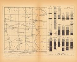
- Caption title: East-west section through Hoosierville and Asherville. Relief shown by profile. Index map showing locations of coal fields around Hoosierville and Asherville located in Clay County, Indiana, 1 geological cross-section through the two cities, 18 stratigraphic columns with correlation lines. Plate XXXI. Detached from: The coal deposits of Indiana / George Hall Ashley. In Indiana Department of Geology and Natural Resources twenty-third annual report, 1898. Indianapolis : Wm. B. Burford, 1899. Page 592.
- Call Number
- G4093.C5H9 1898 .C63
- Caption
- Imprint: [Indianapolis] : [Indiana Department of Geology and Natural Resources], [1899]
- Filename
- VAC3073-M-00248
- Subject
- Topical Subject: Geology, Stratigraphic
- Topical Subject: Coalfields
- Topical Subject: IGS Annual Reports
- Geographic Subject: Clay County (Ind.)
- Topical Subject: Stratigraphic correlation
- Topical Subject: Coal reserves
- Title
- Coal map : Hoosierville T 12 N. R.6 W. Asherville
- Physical Description
- Dimensions: 23 x 28 cm
- Scale: Approximately 1:63,360
- Item Identifiers
- Alternate ID: 390726IP
- Title Control Number: a18214672
- Persistent Identifier
- Campus
- IU Bloomington
- Date Created
- 1899
- Provenance
- 23rd Annual Report (1898) / Indiana. Department of Geology and Natural Resources.
- Publisher
- Indiana. Department of Geology and Natural Resources
Relationships
Relationships
- In Collection:
Items
Show Item Images
| Thumbnail | Title | Date Uploaded | Visibility | Actions |
|---|---|---|---|---|
|
VAC3073-00090.jp2 | 2023-09-22 | Public |
|