
Image
Indiana, Ditney quadrangle [1902 printing] Public Deposited
- Genre
- Quadrangle maps
- 30 minute topographic maps
- Topographic maps
- Location
- Coordinates: W0873000 W0870000 N0383000 N0380000
- Related URL
- Abstract
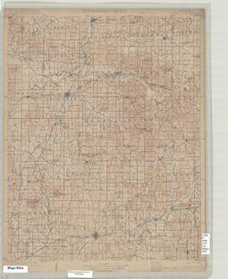
- Indiana, 30 minute series (topographic). Filing title: Ditney, Ind. Jno. H. Renshawe, geographer in charge , topography by H.B. Blair, R.C. McKinney, and Chas W. Goodlove , engraved Aug. 1902 by U.S.G.S. Edition of Nov. 1902. Polyconic projection. Relief shown by contour lines and spot heights. Contour interval 20 feet. Surveyed in 1899-1900 and 1902. Shows portions of Warrick and Pike counties, as well as small portions of Gibson, Vanderburgh, Spencer, and Dubois counties in Indiana. Includes diagram of township. Reprinted 1936. On 1936 reprint: "Engraved Aug. 1902 by U.S.G.S." and "Polyconic projection." On 1936 reprint: "Maps of Velpen, Petersburg, Boonville, and Degonia Springs quadrangles, scale 1:62,500, contour interval 5 feet, from later and more detailed surveys of this area are available."
- Call Number
- G4090 s125 .G4 Ditney 1902
- Caption
- Imprint: [United States] : Geological Survey, [1902]
- Filename
- VAC3073-M-01416
- Subject
- Geographic Subject: Dubois County (Ind.)
- Geographic Subject: Warrick County (Ind.)
- Geographic Subject: Vanderburgh County (Ind.)
- Geographic Subject: Gibson County (Ind.)
- Geographic Subject: Spencer County (Ind.)
- Geographic Subject: Pike County (Ind.)
- Title
- Indiana, Ditney quadrangle [1902 printing]
- Producer
- McKinney, R. C. (Robert C.)
- Geological Survey (U.S.)
- Blair, H. B. (Herbert Buxton), 1860-1905
- Renshawe, John H.
- Goodlove, C. W.
- Physical Description
- Dimensions: 45 x 36 cm
- Scale: 1:125,000
- Item Identifiers
- Title Control Number: a18416043
- Persistent Identifier
- Campus
- IU Bloomington
- Date Created
- 1902
- Provenance
- Part of Geological Survey (U.S.). Indiana 1:125,000.
- Publisher
- Geological Survey (U.S.)
Relationships
Relationships
- In Collection:
Items
Show Item Images
| Thumbnail | Title | Date Uploaded | Visibility | Actions |
|---|---|---|---|---|
|
VAC3073-M-01416.jp2 | 2023-09-28 | Public |
|