
Image
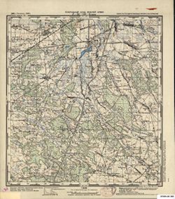
N-34-128-В Ядув Public Deposited
- Genre
- Topographic Maps
- Military Maps
- Location
- Coordinates: 52.333, 21.5, 52.5, 21.75
- Related URL
- Abstract
- Modern area represented: Jadów, Poland
- Call Number
- G7000 s50 .S68 sheet N-34-128-C
- Caption
- Captured map
- City
- Ядув (Jadów)
- Copyright Owner
- No Copyright - United States
- Country
- Область государственных интересов Германии (Region of German state interest)
- Filename
- VAC9619-000293
- Subject
- Geographic Subject: Jadów
- Topical Subject: Maps
- Topical Subject: Soviet Union
- Title
- N-34-128-В Ядув
- Physical Description
- Scale: 1:50,000
- Language
- Russian
- Persistent Identifier
- Campus
- IU Bloomington
- Date Created
- 1941
- Provenance
- Army Map Service Library, OMAHA, Library of Congress Geography & Map Division
- Publisher
- Генеральный штаб Красной Армии
Relationships
Relationships
- In Collection:
Items
Show Item Images
| Thumbnail | Title | Date Uploaded | Visibility | Actions |
|---|---|---|---|---|
|
VAC9619-000293.jp2 | 2023-11-28 | Public |
|
|
VAC9619-U-002450.jp2 | 2023-11-28 | Public |
|