
Image
Hutsonville quadrangle, Illinois-Indiana : 15 minute series (topographic) [1957 printing with vegetation] Public Deposited
- Genre
- 15 minute topographic maps
- Topographic maps
- Quadrangle maps
- Location
- Coordinates: W0874500 W0873000 N0391500 N0390000
- Related URL
- Abstract
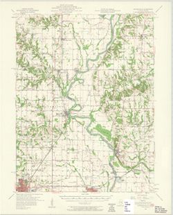
- Mapped, edited, and published by the Geological Survey , control by USGS, USC & GS, and USCE. Filing title: Hutsonville, Ill.-Ind. Standard map series designation: AMS (Series) V763 3462 II. [Edition of] 1957. Polyconic projection. Relief shown by contours and spot heights. Contour interval 10 feet. Includes quadrangle location map. Reprinted with AMS series information in 1969. Some copies have forest areas colored green. "Topography in Illinois from aerial photographs by Kelsh plotter, Aerial photographs taken 1956. Field check 1957, Topography in Indiana by planetable surveys 1940-1941, Culture revised from aerial photographs taken 1956. Field check 1957." "The east half of this area also covered by 1:24,000 scale maps of Fairbanks and Merom 7.5 minute quadrangles, surveyed 1940-1941. Culture revised 1957." "N3900--W8730/15."
- Call Number
- G4090 s62 .G4 Hutsonville 1957
- Caption
- Imprint: Indianapolis, Ind. : Indiana Department of Conservation, [1958]
- Imprint: Washington, D.C. : for sale by U.S. Geological Survey
- Imprint: Urbana, Illinois : State Geological Survey
- Imprint: Washington, D.C. : Interior-Geological Survey, 1957
- Filename
- VAC3073-M-01346
- Subject
- Geographic Subject: Crawford County (Ill.)
- Geographic Subject: Sullivan County (Ind.)
- Topical Subject: Vegetation mapping
- Geographic Subject: Clark County (Ill.)
- Title
- Hutsonville quadrangle, Illinois-Indiana : 15 minute series (topographic) [1957 printing with vegetation]
- Producer
- Geological Survey (U.S.)
- Indiana. Department of Conservation
- Illinois State Geological Survey
- Physical Description
- Dimensions: 45 x 42 cm or smaller
- Scale: 1:62,500
- Item Identifiers
- Title Control Number: a18408296
- Persistent Identifier
- Campus
- IU Bloomington
- Date Created
- 1957
- Provenance
- Part of Geological Survey (U.S.). Indiana 1:62,500.
- Publisher
- Geological Survey (U.S.)
Relationships
Relationships
- In Collection:
Items
Show Item Images
| Thumbnail | Title | Date Uploaded | Visibility | Actions |
|---|---|---|---|---|
|
VAC3073-M-01346.jp2 | 2023-09-28 | Public |
|