
Image
Indiana Bloomington quadrangle [1946 reprint] Public Deposited
- Genre
- 15 minute topographic maps
- Topographic maps
- Quadrangle maps
- Location
- Coordinates: W0864500 W0863000 N0391500 N0390000
- Related URL
- Abstract
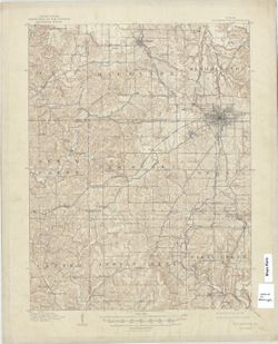
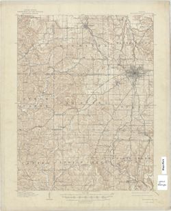
- R. B. Marshall, chief geographer , W. H. Herron, Geographer in charge , topography by W. H. Griffin and C. L. Sandler , Control by J. R. Ellis and C. H. Semper. Variant title: Bloomington quadrangle. Filing title: Bloomington, Ind. Edition of Feb. 1910. Polyconic projection. Relief shown by contours and spot heights. Contour interval 20 feet. Surveyed in 1907-1908. Reprinted in 1931, 1946, 1948, and 1958. Edition and reprint statement dropped from 1958 reprint. Other 1946 reprint includes handwritten index of caves. "N3900-W8630/15."
- Call Number
- G4090 s62 .G4 Bloomington 1910 R1946
- Caption
- Imprint: [Washington, D.C.] : United States, Department of the Interior, Geological Survey, [1946]
- Filename
- VAC3073-M-01295
- Subject
- Geographic Subject: Monroe County (Ind.)
- Geographic Subject: Owen County (Ind.)
- Geographic Subject: Greene County (Ind.)
- Title
- Indiana Bloomington quadrangle [1946 reprint]
- Producer
- Griffin, W. H. (William H.)
- Marshall, R. B. (Robert Bradford), 1867-1949
- Herron, W. H. (William Harrison), 1865-
- Sadler, C. L.
- Physical Description
- Scale: 1:62,500
- Dimensions: 45 x 42 cm or smaller
- Item Identifiers
- Title Control Number: a18406221
- Persistent Identifier
- Campus
- IU Bloomington
- Date Created
- 1946
- Provenance
- Part of Geological Survey (U.S.). Indiana 1:62,500.
- Publisher
- Geological Survey (U.S.)
Relationships
Relationships
- In Collection:
Items
Show Item Images
| Thumbnail | Title | Date Uploaded | Visibility | Actions |
|---|---|---|---|---|
|
VAC3073-M-01295.jp2 | 2023-09-28 | Public |
|
|
VAC3073-00665.jp2 | 2023-09-28 | Public |
|