
Image
Map of Illinois Public Deposited
- Series
- GLOVE - Local and Regional Maps
- Abstract
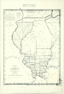
- The lands surveyed for the military contains about 5,576,780 acres. Out of which have been selected for the British Lands, 3,500,000 acres. Remaining for sale by the U.S., 2,075,680. Each square of the surveys is denominated as a Township, and contains 6 miles square, square being 36 square miles, or 23,040 acres of land. The Townships are subdivided into sections of a mile square, or 640 acres, and are numbered as in the following specimen. No. 16 is uniformly appropriated for the use of a school in the Township, and number 15, 21 & 22 are reserves in the hands of the U.S. to be disposed of by order of Congress.
- Call Number
- GLV132
- Copyright Holder
- Public Domain
- Country
- United States
- Persistent URL
- Source Identifier
- VAD5944-000015
- Subject
- American Indians
- Illinois
- United States--Maps
- Indians of North America
- Holding Location
- Bloomington - Indiana University Museum of Archaeology and Anthropology
416 North Indiana Avenue
Bloomington, IN 47408
Contact at iumaa@iu.edu, 812-855-6873
- Bloomington - Indiana University Museum of Archaeology and Anthropology
- Campus
- IU Bloomington
- Source Metadata Identifier
- Title
- Map of Illinois
- Creator
- Melish, John
- Date Created
- 1818
Relationships
Relationships
Items
Show Item Images
| Thumbnail | Title | Date Uploaded | Visibility | Actions |
|---|---|---|---|---|
|
VAD5944-000015.tif | 2023-04-12 | Public |
|